Download Agreement, Release, and Acknowledgement of Risk:
You (the person requesting this file download) fully understand mountain climbing ("Activity") involves risks and dangers of serious bodily injury, including permanent disability, paralysis, and death ("Risks") and you fully accept and assume all such risks and all responsibility for losses, costs, and damages you incur as a result of your participation in this Activity.
You acknowledge that information in the file you have chosen to download may not be accurate and may contain errors. You agree to assume all risks when using this information and agree to release and discharge 14ers.com, 14ers Inc. and the author(s) of such information (collectively, the "Released Parties").
You hereby discharge the Released Parties from all damages, actions, claims and liabilities of any nature, specifically including, but not limited to, damages, actions, claims and liabilities arising from or related to the negligence of the Released Parties. You further agree to indemnify, hold harmless and defend 14ers.com, 14ers Inc. and each of the other Released Parties from and against any loss, damage, liability and expense, including costs and attorney fees, incurred by 14ers.com, 14ers Inc. or any of the other Released Parties as a result of you using information provided on the 14ers.com or 14ers Inc. websites.
You have read this agreement, fully understand its terms and intend it to be a complete and unconditional release of all liability to the greatest extent allowed by law and agree that if any portion of this agreement is held to be invalid the balance, notwithstanding, shall continue in full force and effect.
By clicking "OK" you agree to these terms. If you DO NOT agree, click "Cancel"...
Climbing Snowmass Mountain was harder than I expected. More on that later.
I was unable to get any of my climbing partners from Pueblo or Colorado Springs to join me but was able to meet up with a friend, Grace, for the approach and then later, at Snowmass Lake, new friends Louis and Gabe for the climb.
I departed Pueblo after work on Thursday and made the 4.5 hour drive to near the Maroon-Snowmass trailhead getting in about10:45 pm. I say near because I had trouble finding the actual trail head in the dark and ended up sleeping at the Park and Ride lot off HWY 82. Hmmm... there seems to be some errors in Roach's directions to the trailhead (23T). I'd recommend double checking the directions with other sources. After a night in the Subaru, I was able to make the short drive, with Grace following, to the trailhead. The trailhead is much easier to find in the daylight. There were plenty of cars in the lot already. If the lot is full, there are places to park along the road coming in.
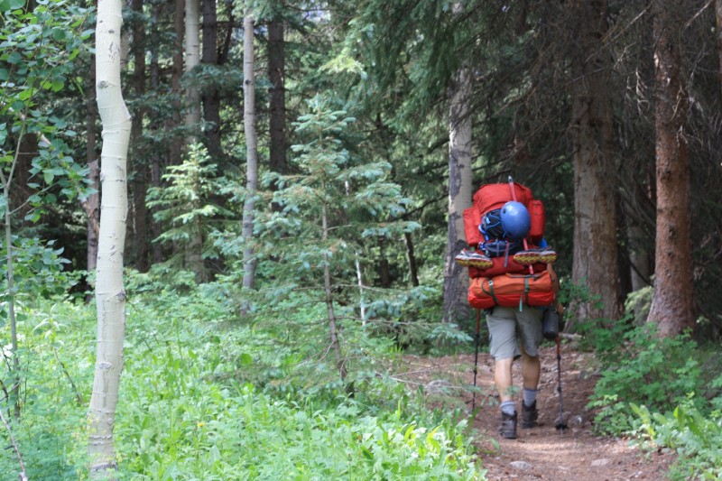
We were on the trail by 8:30 for the leisurely 8.5 mile hike to Snowmass Lake. Photo by Grace.
The trail follows Snowmass Creek with the first half weaving through aspen trees before opening up into some spectacular views.
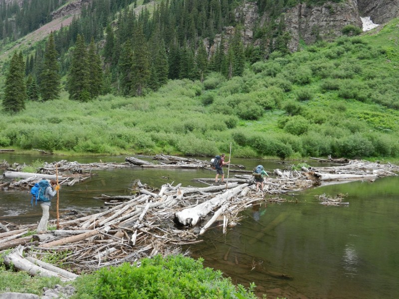
The famous "logjam" crossing is a little over 6 miles in. It's a balancing act made a lot easier with trekking poles. You can also wade across the creek below the log jam. It was about thigh deep and very cold.
After the logjam crossing, the trail gains some significant elevation until you arrive at Snowmass Lake. There are good camping spots about a half mile before the lake and then closer to the lake. The mosquitoes were pretty bad. Selecting a tent site in the open (as opposed to in the trees) will allow more of a breeze to help keep the tiny little bloodsuckers away. Here we met Gabe and Louis who pitched their tents with us. Hmmm.... It looks like I didn't get the "tent memo". My red tent seems out of place. Photo by Grace.
Gabe, Louis, and I got up around 2:30 and began hiking for the summit before 3:30. We could see headlamps ahead of us.
The standard route up Snowmass Mountain from Snowmass Lake contains four unique segments, each with their own challenges.
First, you have to pass through the willows on the south side of the lake.
Yes, there is a trail, but it is extremely hard to follow in the dark, by headlamp since the willow branches do a great job covering up the path. The willows were covered with dew. Rain pants and gaiters will help keep you dry. I got lost a couple times and had to fumble around, fighting the willows, wasting time and energy while trying to find the trail again. Almost every other climber I spoke with later said they had lost the trail in the willows too. On the way back to base camp, in the daylight, I was able to follow the path. The gpx track below is actually from the summit back to base camp (reversed) and accurately reflects the path through the willows. I hope it helps you out. I got separated from Gabe and Louis in the willows but caught up with them in the basin.
Second, you will have to climb (and descend on return) the steep scree slope at the west end of the lake. This slope is steep enough to pose rock-fall hazard to any climbers below. A helmet is definitely a good idea. At about 11,900', near the top of the slope, it is easier climbing if you cross over the drainage towards climber's right and finish ascending into the basin. I found descending the scree slope very unpleasant. Here's a photo of the scree slope, and me showing my appreciation for the scree slope.
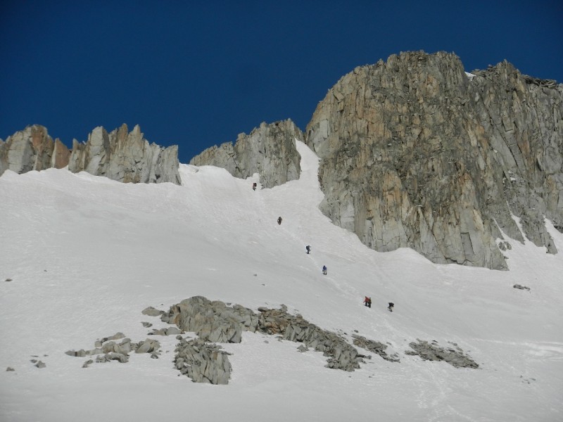
Third, you must ascend the snow mass to gain the ridge. This was my favorite part of the climb. I was on the snow by 7:30. Once the sun starts warming the snow, it becomes really easy to posthole and more dangerous to climb on the steeper segments. The first half of the snow is very low angle and can be walked in hiking boots or runners. As you climb out of the basin, the slope steepens significantly with the steepest section right before gaining the ridge. Here crampons and an ice axe are a very good idea. Myself, and all the other climbers I saw elected to gain the ridge close to the summit as described in Roach's book as variation 23R1 V -Max Snowmass. The photos shows a line of climbers heading for the exit point onto the ridge.
The move off the snow onto the ridge had to be made carefully with corniced snow immediately to the left and a large drop immediately to the right caused by the snow melting back from the rock wall. This option to gain the ridge is probably disappearing quickly as the snow melts.
The fourth (and final) segment involves scrambling less than a quarter mile along the rocky ridge to the summit. As with all mountains in the Elks, the rock is sketchy. In fact, a climber ahead of me had his right arm broken when a boulder the size of a small car shifted, nearly crushing him. Several, wonderful climbers helped him get off the summit and Colorado SAR and a military Blackhawk helicopter had him in route to a hospital within three hours of the distress call. That was fast! Nice work to all. Be extra careful with every hand hold and foot hold. I found the most stable route to be directly on the top of the ridge. In the photo, you can barely see the group of hikers who are helping the injured hiker (in blue) descend.
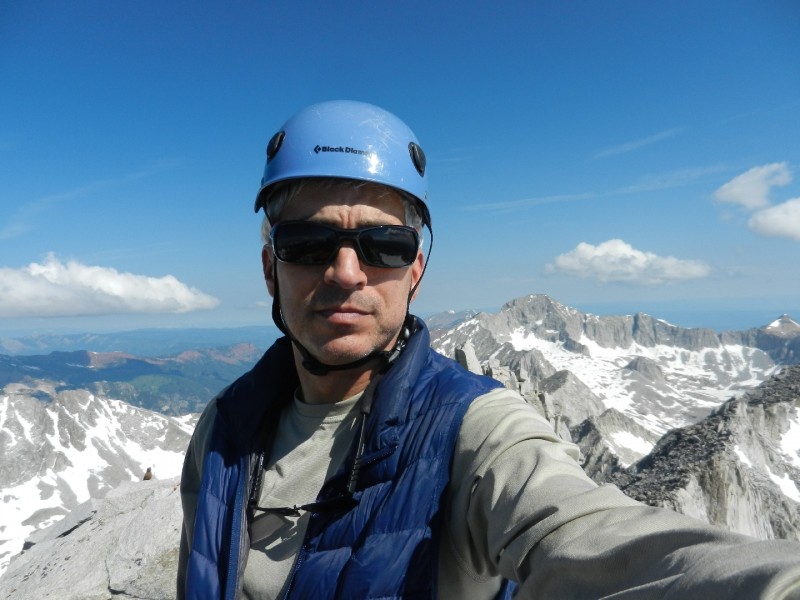
When you are within about 40 or 50 yards of the summit, you'll run into a tall block of rock with a thin flake of rock angling out above. At first glance, this may seem like a tough obstacle blocking your path to the summit. It's actually not to bad. Look carefully around climbers right on the block and you'll see a series of excellent foot holds allowing you to scale this obstruction while the angled flake provides a solid hand hold. After you clear this last block, the summit is easily reached where you'll have great views in all directions including a nice look at Capitol Peak.
As I was getting ready to move from the ridge back onto the snow, I caught a photo of Chris getting ready to drop off for some turns. I hope you had a good run.
I retraced my route (minus the wandering in the willows) back to base camp. It was great meeting up with old friends and making new ones. My struggles in the willows and on the scree slope made this climb harder than expected. Still, the climb was a great experience and the approach along Snowmass Creek absolutely beautiful. Just be prepared to work for this one!
My GPS Tracks on Google Maps (made from a .GPX file upload):
You said you left camp around 3:30am and didn’t start climbing on the snow until 7:30am? Is that right? 4 hours from the lake, through the willows and to the top of the scree field?
PaliKona, the times are not exact but yes, with getting lost in the willows and not being the fastest hiker, it took me about 4 hours before I was on solid snow. The scree field takes some time.
I concur.... the willows blow. Everyone that I talked to that day got lost and soaked in the willows. The trail is more obvious on the way down and in the daylight.
I took a little different route and didn’t go up the scree. I crossed and went up the grass/dirt route. I think it was much nicer.
I believe we passed you just about at the top of the snow field. So far this was the nicest day of the last week. Glad you guys made it. I/we were coming down and you were headed up. You’re welcome for the kicked in route :D .
Damn shame about the "rescue" that really wasn’t a rescue. Costly and dangerous to everyone.
the 2 individuals that got "rescued" were not in any danger, hurt or lost. Myself and another group passed the 2 kids on our descent. Neither yelled for help or looked hurt or wanted anything. One made the comment/questions about whether there was any snow to the summit as he was sitting only 150 yards from it and 1000’s of feet of it. My guess is he had a little too much extra goodies in his breakfast.
Both were dressed in t–shirts, shorts and tennis shoes and didn’t have any gear. A woman at the lake made the comment about them being only 3 hours late to come down at 10am. I put 2 and 2 together and low and behold they got escorted off the mtn by what I believe was 2 SAR people. Who did not look happy. They walked, under their own power all the way to the TH.
I would also add that they were never really more than 100–200 yards from people the whole morning. Or at least the route. There were tons of people on that mtn that day.
It’s great they weren’t hurt and didn’t need medical attention but at the same time this rescue could have been avoided. Unless I’m totally way off base here and someone else who was there that day has more/better info. I believe this is what happened.
The willows will be wet from run–off and are just a pain. I was on snow in about 1 hour and 45 mins from the lake.
Herdbull, I had not heard of the two hikers escorted off the mountain by SAR. I was only aware of the guy who broke his arm on the 4th of July.
Caution: The information contained in this report may not be accurate and should not be the only resource used in preparation for your climb. Failure to have the necessary experience, physical conditioning, supplies or equipment can result in injury or death. 14ers.com and the author(s) of this report provide no warranties, either express or implied, that the information provided is accurate or reliable. By using the information provided, you agree to indemnify and hold harmless 14ers.com and the report author(s) with respect to any claims and demands against them, including any attorney fees and expenses. Please read the 14ers.com Safety and Disclaimer pages for more information.
Please respect private property: 14ers.com supports the rights of private landowners to determine how and by whom their land will be used. In Colorado, it is your responsibility to determine if land is private and to obtain the appropriate permission before entering the property.


")
")
")
")
")
")
")
")
")
")


