Download Agreement, Release, and Acknowledgement of Risk:
You (the person requesting this file download) fully understand mountain climbing ("Activity") involves risks and dangers of serious bodily injury, including permanent disability, paralysis, and death ("Risks") and you fully accept and assume all such risks and all responsibility for losses, costs, and damages you incur as a result of your participation in this Activity.
You acknowledge that information in the file you have chosen to download may not be accurate and may contain errors. You agree to assume all risks when using this information and agree to release and discharge 14ers.com, 14ers Inc. and the author(s) of such information (collectively, the "Released Parties").
You hereby discharge the Released Parties from all damages, actions, claims and liabilities of any nature, specifically including, but not limited to, damages, actions, claims and liabilities arising from or related to the negligence of the Released Parties. You further agree to indemnify, hold harmless and defend 14ers.com, 14ers Inc. and each of the other Released Parties from and against any loss, damage, liability and expense, including costs and attorney fees, incurred by 14ers.com, 14ers Inc. or any of the other Released Parties as a result of you using information provided on the 14ers.com or 14ers Inc. websites.
You have read this agreement, fully understand its terms and intend it to be a complete and unconditional release of all liability to the greatest extent allowed by law and agree that if any portion of this agreement is held to be invalid the balance, notwithstanding, shall continue in full force and effect.
By clicking "OK" you agree to these terms. If you DO NOT agree, click "Cancel"...
"How long will it take me to climb and ski Snowmass from Marble" I wondered to myself, as I planned my next adventure.
According to his guide book, Lou Dawson doesn't consider this trip to be doable in one day from winter closure. Davenport and his partner took 13 hours from the Lead King basin, half the distance I intended to travel. I'm not quite at their fitness level, and I don't have trail breaking partners, however, they did report terrible climbing conditions. And I know, from experience how bad cramponing conditions can more than double your regular time.
There are a lot of variables to consider in order to estimate the time a tour will take. I like to consider recent trips. Last year I climbed and skied 7,500 vertical feet and 22 miles up and down Pikes Peak. That trip took me fifteen hours. Let's consider the variables. I had to break trail through fresh powder solo...that slowed me down. I was able to skin to the summit...that sped me up, compared to cramponing. A lot of the climb was at low elevation...that is faster than high altitude climbing. And the snow was continuous from the summit to the base...that makes for a quick decent.
Next I considered my Harvard ski of this year. I climbed and skied about 19 miles and gained 5,500 vertical feet. It only took me 9 hours. However, I didn't have any considerable trail breaking, no cramponing was involved, and I had a quick, continuous ski on the way out.
Lastly, I will consider my recent Mt. Wilson/South Wilson trip. This trip had roughly 7,000 vertical feet gain, and was about 14 miles round trip. Most of the hiking was at high altitude (6,000' gain above 11,000' elevation) and it did involve cramponing and booting up snow. On the other hand, there was no real trail breaking (other than the booter), and there was continuous snow to ski out on (except for 2 mi, round trip, of flat to moderate elevation gain bushwhacking). This trip took me about 14 hours.
What variables do I expect for Snowmass? Well, on the one hand, the elevation starts low (like Pikes Peak and Harvard). On the other hand, I expect a large distance (as much as 22 mi) from winter closure (much like Pikes Peak). However, on the circus-side-show-freak's third hand, I expect a supportable spring snow pack which will reduce any trail breaking hindrances (unlike Pikes and more like Wilson and Harvard). And then on the disgusting freak's fourth hand, I will have to do a whole lot of cramponing up the face, which will increase the estimated time (it probably won't be as bad as Davenport's trip, and probably be more like my Wilson trip). Finally, on the abomination of nature's fifth hand, I hope to have a well packed snowy trail to quickly descend out on.
A lot of variables to consider. I think I'll avoid too much thinking and just go with the estimation I always use on moderate to long hikes...twelve hours. So if I start hiking by 4 a.m., I should be back at the car by 4 p.m. Very reasonable!
Sunday, April 5th, I drove down to the town of Marble and headed up FR 314. I was able to drive just past the junction of FR 314 (road to Crystal) and FR 315 ("high road") before coming to snow. I car camped here at Lost Trail Creek. A sign said four miles to Crystal, so from my Dawson's guide book, I assume this takes off 3 mi round trip from the 22 mi winter route. Thus, I was looking at a 19 mi round trip day and starting around 8,700' elevation. Nevertheless, I still assumed it would be a twelve hour day (I think it would take something very major to make me budge my estimate from that golden number).
The next day, I hit the trail at ten to five. There have been a few times in the past where I've started hiking as soon as I come to deep snow, even when tire tracks indicate I could drive further, just to discover that the snow ends and that I could have knocked several miles off my trip by driving further. Today was to be one of those days.
I quickly discovered that if I had brought my tire chains, I could have busted through the snow, as a previous driver had been smart enough to do, and knock off about 1.5 to 2 miles on the approach (or 3 to 4 miles round trip).
In hindsight, I should have considered my winter Mt. Lindsey tour (http://www.14ers.com/php14ers/tripreport.php?trip=15826&parmpeak=Mt.+Lindsey&cpgm=tripmain&ski=Include) in my pre analysis. South facing roads tend to melt out. Lesson (finally) learned.
The longer I walked on a bone dry road, the angrier I became. I hoped there would be a large impassible snow drift or avy debris that would have justified not driving. None came. In order to revive my spirits, I came up with a new rule for skiing Snowmass...it doesn't count unless you get at least the elevation gain and mileage that I was about to do.
I am hereby proposing this new rule to the 14er community. If you agree with this rule, please vote yes by giving the trip report a "thumbs up." If you disagree, give it a thumbs down. I'm confident everyone will see things my way.
Confident that everyone would see things my way, I pressed on with revived spirits. I arrived at Crystal in 1.5 hours. For the past two miles, numerous signs warned me of private property and to stay on the road. Also, the single word "posted" was posted on several roadside boulders. I found this to be very redundant. It's like a sign that says "this is a sign" No trespassing signs and warnings that the private property was under video surveillance, made it very clear I shouldn't stray from the road. I've even heard tales of an amorous guard yeti that has been known to confuse humans with his own species and violate the violators. I did not want to test this theory and kept on the road.
At the top of the switchbacks above Crystal, I finally came to continuous snow.
Avy debris, broken tree limbs, and trees without upslope branches indicated that these slopes slide frequently during the winter.
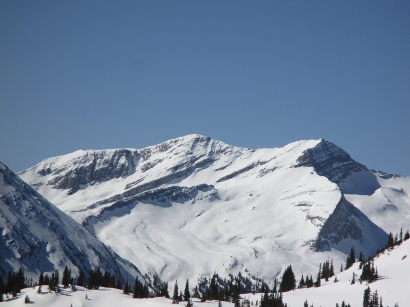
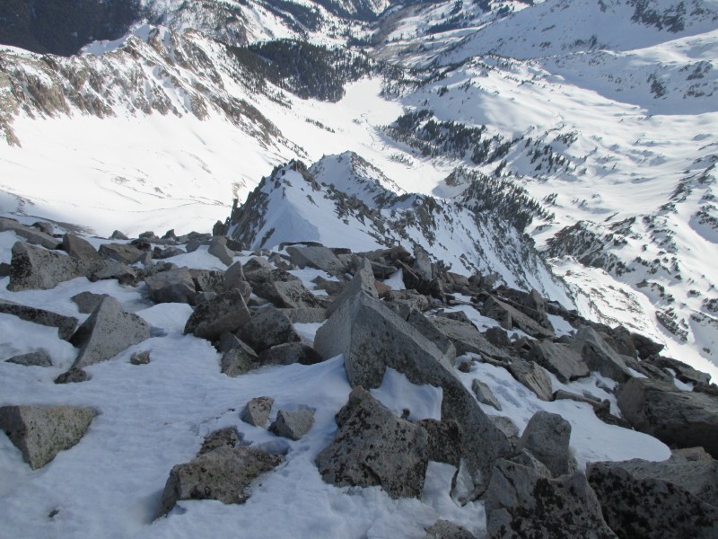
First view of Snowmass
Above the Lead King trail head, I lost sight of human tracks and lost the trail. I had to gain and loose a little bit of elevation to find convenient paths across side streams. But the scenery was nice.
A couple hundred feet below Geneva Lake, a little Shy Guy from Super Mario Bros 2 told me to head climbers left through the easy, treeless terrain.
Shy Guy
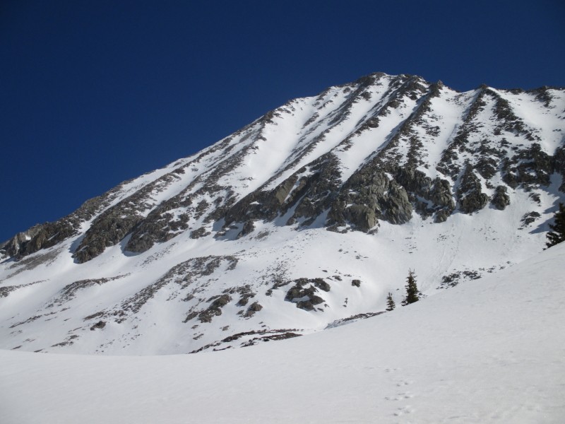
I thought that I would be able to cut right for an easy path to Geneva Lake, but the more I climbed, the more I realized I was veering too far to the left. I didn't want to loose elevation and continued on my path to a ridge where I could finally view the basin I should have been in. I had to lose a couple hundred feet of elevation to ski towards the base of Snowmass' west face, but this path allowed me to get this nice shot.
I couldn't see what the terrain was like alongside the creek near the base of Snowmass, and decided to follow open terrain to climbers' left of the creek. This caused me to gain and then lose a bit more elevation, but nothing to cry about.
At the base of Snowmass' left face, I began the booter up. First without crampons, and then with them on.
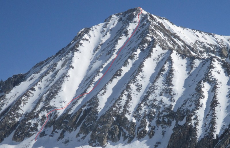
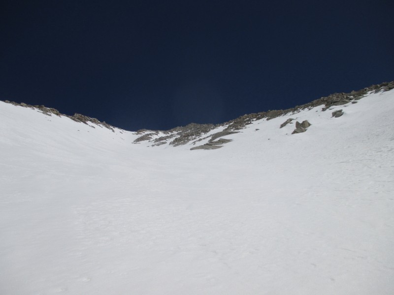
The crux of the climb and ski was making my way through the cliff bands at the base of the face. The snow was steep (estimated 50 degrees), icy, and had one narrow section through rocks. Here's the climb and ski route:
Once above this "entrance" section, the gullies are wide open and of lower angle (high thirties I would estimate). Above the lower rock bands, my route which is more or less the standard route puts you in a gully that does not ascend to the summit. I had to cross a rocky rib to climbers' right to get to the gully that ascends to the south of the summit. Crossing the rock rib can easily be done at nearly any point, however I chose a section that had continuous snow so that I could follow my tracks on the descent for a continuous snow route.
Climbing the face took a very very long time! I started the booter around 11:30 a.m. and didn't make the summit until 4:30 p.m. Damn!
Most of the main gully was estimated to be around 40 degrees or lower. The top section steepened to mid to upper forties (estimated). The gully ends at the south ridge, which had a nice cornice which gave me a snow route to the summit.
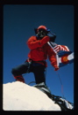
Summiting so late, I decided not to spend much time up there. Here's me
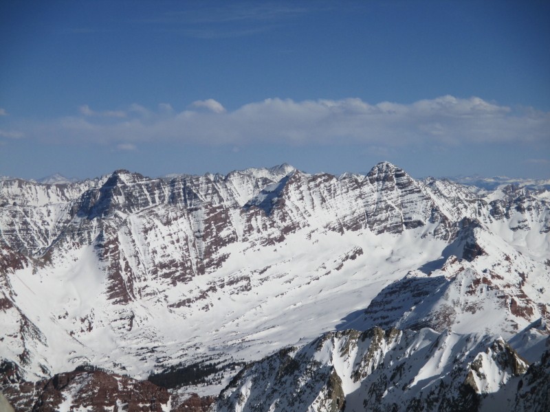
Here are the bells and Pyramid
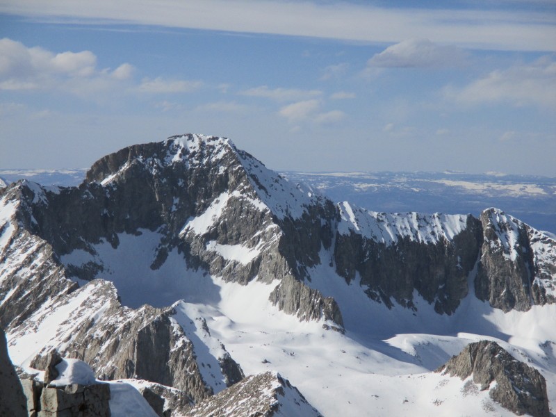
There's also one other nearby fourteener to the North. I don't like to speak of this mountain. Every time I look at this mountain, I get the creeps and have to go off to my happy place like the gingerbread man in Shrek.
It's the gooood ship, lollipop
After taking the minimum amount of summit pics, I geared up and started the descent.
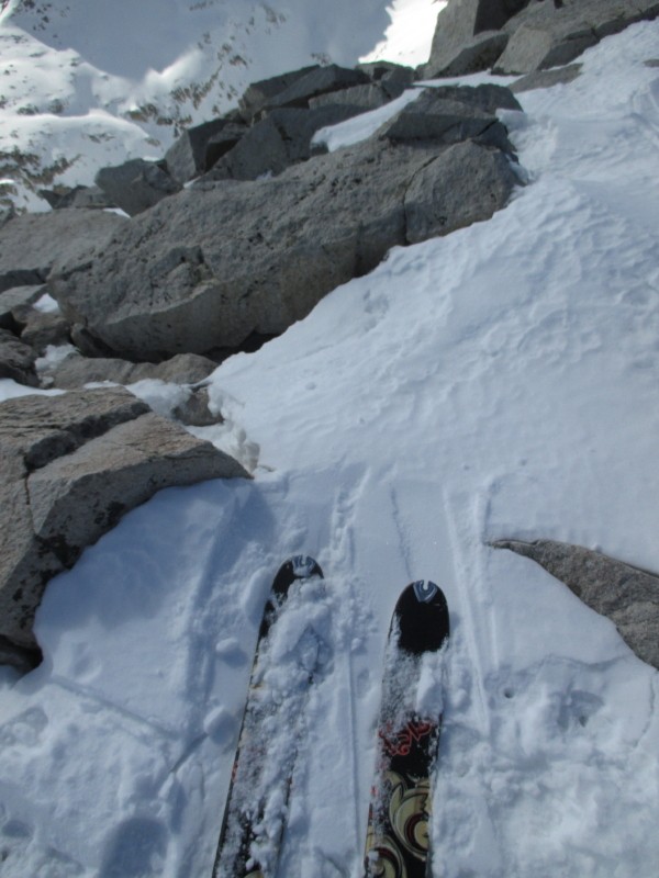
The rocky upper section. Skiable snow is out of view on left
The upper most portion was rocky and required side stepping, but I was able to keep my skis on snow. Descending to skiers left, I got out of the rocks and took the south face cornice to the top of the gully.
One last rocky section before I can open it up
Time to open it up
Time to rest
The descent was icy, but my fatties were still able to hold a decent edge.
By the time I got off the face, I was feeling pretty worn out. The egress took a bit longer than expected, powered by tired legs. I made it back to the car at 9:30 p.m. for a round trip time of about 16 hours and 40 minutes. Exactly as I had predicted!
I headed home, but only made it to the Minturn park and ride off of I-70 before calling it a night. The next morning I completed the trip home, with one quick stop in Woodland Park...
Thumbnails for uploaded photos (click to open slideshow):
Solely reflects how I feel about your report... way to kill it Mike!
I don’t know why, but yesterday as I was hauling ski and climbing gear from 8,600 on Como road for Little Bear I kept thinking of your solo ski and was thinking I would call you madmike bc that road blows and doing it solo would make me go mad. We ultimately bailed before the hourglass due to depleted energy from hiking since 10pm the night prior.
Thanks for the comments, everyone! 4/14/2015 2:53pm
And thanks to all of you who voted in my favor :D
jmc5040 and blazintoes: I think madmike is already taken, and I hope Magic Mike never catches on :wink:. I think I’ll stick with Money Mike for now...even though that name is becoming increasingly ironic the more I devote myself to backcountry skiing.
Caution: The information contained in this report may not be accurate and should not be the only resource used in preparation for your climb. Failure to have the necessary experience, physical conditioning, supplies or equipment can result in injury or death. 14ers.com and the author(s) of this report provide no warranties, either express or implied, that the information provided is accurate or reliable. By using the information provided, you agree to indemnify and hold harmless 14ers.com and the report author(s) with respect to any claims and demands against them, including any attorney fees and expenses. Please read the 14ers.com Safety and Disclaimer pages for more information.
Please respect private property: 14ers.com supports the rights of private landowners to determine how and by whom their land will be used. In Colorado, it is your responsibility to determine if land is private and to obtain the appropriate permission before entering the property.


")
 First view of Snowmass")
")
 Shy Guy")
")
")
")
")
")
")
")
")
 It's the gooood ship, lollipop")
")
 The rocky upper section. Skiable snow is out of view on left")
")
 One last rocky section before I can open it up")
 Time to open it up")
 Time to rest")
")
")
")
")