Download Agreement, Release, and Acknowledgement of Risk:
You (the person requesting this file download) fully understand mountain climbing ("Activity") involves risks and dangers of serious bodily injury, including permanent disability, paralysis, and death ("Risks") and you fully accept and assume all such risks and all responsibility for losses, costs, and damages you incur as a result of your participation in this Activity.
You acknowledge that information in the file you have chosen to download may not be accurate and may contain errors. You agree to assume all risks when using this information and agree to release and discharge 14ers.com, 14ers Inc. and the author(s) of such information (collectively, the "Released Parties").
You hereby discharge the Released Parties from all damages, actions, claims and liabilities of any nature, specifically including, but not limited to, damages, actions, claims and liabilities arising from or related to the negligence of the Released Parties. You further agree to indemnify, hold harmless and defend 14ers.com, 14ers Inc. and each of the other Released Parties from and against any loss, damage, liability and expense, including costs and attorney fees, incurred by 14ers.com, 14ers Inc. or any of the other Released Parties as a result of you using information provided on the 14ers.com or 14ers Inc. websites.
You have read this agreement, fully understand its terms and intend it to be a complete and unconditional release of all liability to the greatest extent allowed by law and agree that if any portion of this agreement is held to be invalid the balance, notwithstanding, shall continue in full force and effect.
By clicking "OK" you agree to these terms. If you DO NOT agree, click "Cancel"...
High their, my name is Vomit. Well, I see there's other recent reports on the Bells, so mine probably won't be much different, other than adding Pyramid to the fun. This past weekend my buddy Tyler & I decided to venture to the rotten red rocks near Aspen to take on the three 14ers from the Maroon Lake trail head. We were thinking either tackling this or do Capitol w/ a traverse to Daly. We settled on the Bells just because they seemed more hazardous to climb if we waited any longer in the waning season. I was wanting to try out the Bells Traverse to get some panoramas & to say that I've finally done it. I've climbed both Maroon peaks separately in the past, but never connected them due to weather obstacles & bad planning. This weekend sure seemed to be the perfect moment to be up there. Plan was Pyramid on 9/8/12 & the Bells on 9/9/12.
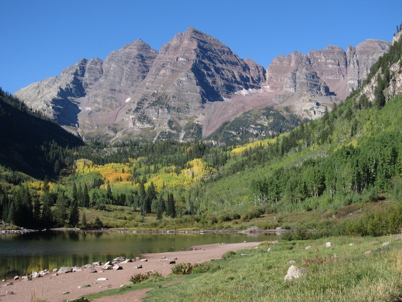
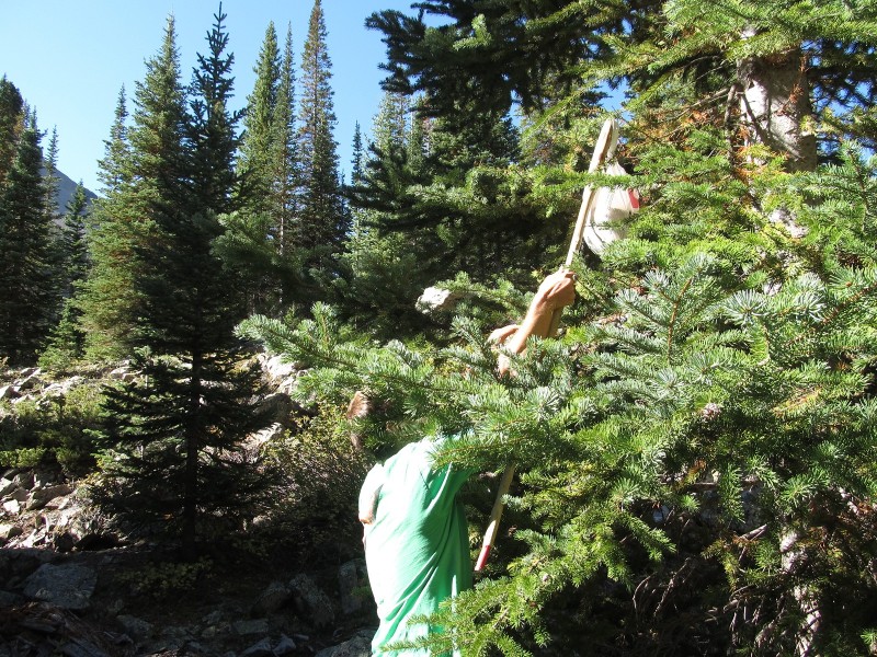
We agreed to meet at a truck stop along I-25 as we were coming from the north at about 4AM on 9/8/12. We actually overshot our destination & met at a parking lot at the north end of Thornton before taking Tyler's truck on the drive westwards on I-70 towards Glenwood Springs. It was about 9AM when we arrived on Maroon Creek Road, paying the $10 entrance fee & being escorted to the parking lot for Maroon Lake. The overnight lot was full so we ended up parking further down at the West Maroon Portal lot & took the 1/2 mile hike up the road to the lakeshore. Classic Maroon Bells from the lake shotFrom the lake & the picturesque view of the Bells, we came to the obvious cairn marking the worn-torn Pyramid Peak trail about 1.3 miles in & we parked our camping supplies in the trees & hid the food from critters before making the climb upwards. Hiding the food up in a tree, which was an absolute fail when it came crashing down moments later. We later covered it w/ roMuch of the climb was straightforward until the amphitheatre where it was rock hopping & inspecting the rocks for small black magnetite crystals. Most of the snow was gone except for the icy rock-stained slopes at the base of Pyramid's dramatic cliff face. We encountered one guy who said there was about 20 people up there, but it was certain we'd have the summit to ourselves once we got up there. It turned out that once we to passed the schlog up to the saddle & began the fun scrambling up, we met a group from the CMC in Golden who were celebrating the 100 year anniversary of their organization. A small group was out summiting each 14er & we met nine of the members on Pyramid.
Past the CMC group, decent warm weather & lack of wind enabled us to plocket (yes, I made that word up) our way to the summit of the 14,018 foot massif. It was a relatively easy & straightforward climb, one that really gave me a re-taste of the Elks since it had been nearly two years since I was last in the area. Pyramid has always been one of my favorite 14ers, primarily because of the views. Nothing signifies Colorado better in my opinion than a direct view across the way of the Maroon Bells, the white fortresses of Snowmass & Capitol, veined mountainsides of golden aspens, & the impressive geomorphology carved by Pleistocene glaciers. The mountains here in particular are always changing, the constant thundering & clanging of rocks that fall down the cliffs as the peak slowly degrades.
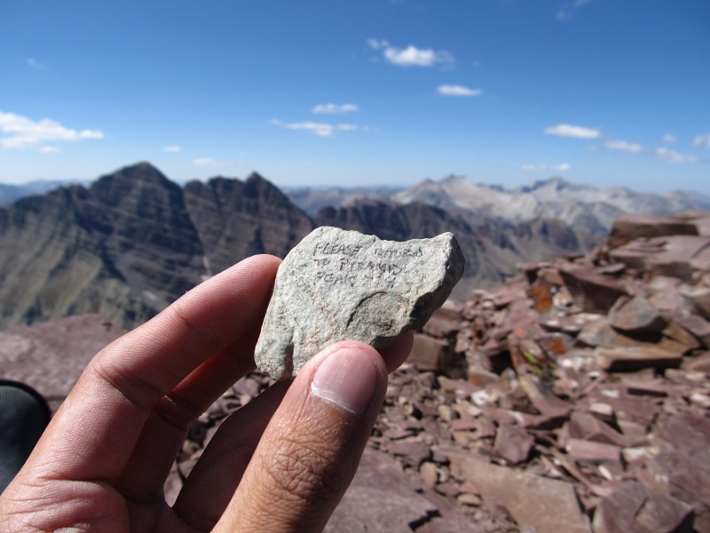
Thunder Pyramid really had our attention, but we knew that it was later in the day & we really had to get ready for Sunday's climb of the Bells Traverse. It looked close & far at the same time, & knowing the rock quality, it would probably take longer than we hoped for. Plus, after we did Thunder Pyramid, our eye would then turn to climbing Lightning Pyramid & then the next peak after that & the next peak that before long, we'd be clear down to the San Juans. Well, not really of course, but it is nice staying on a ridge & taking on a chain of mountains. At the summit of Pyramid, we did meet two fellow hikers from Bosnia that we talked for a bit before I asked them for a photo. The two hikers from Bosnia we met atop Pyramid Found this rock at the summit. Says "Please return to Pyramid Peak TH". So instead I decided to take it to the to Peering down the rock glacier in the amphitheatre & incredible backdrop.
Well, descent came after having the top to ourselves & we made it to the saddle quicker than expected. There's a long flat ridge of rotten looking gendarmes that you typically see on the standard route, & it was tempting to walk out to the furthest one to get a different perspective of the area. They were quite a distance actually & we only made it to the first one where we could see a better view of Pyramid's north face. Several mountain goats were nearby, walking on the down sloping red mudstone w/ ease & licking the rocks for salt. Descending Pyramid
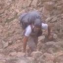
The climb down was straightforward, & I felt myself slip nearly five times down on the gravelly eroded trail, though I never actually fell. It was a decent hike out of the amphitheatre & to the calm evening sky that lit up the lines of vibrant aspen groves against the sun-hit red rock. We came to where we dismounted our camping gear & still found our food & gear intact. Being close to the nearly drained Crater Lake, we began the search for an empty space in one of the 11 campsites that were spread near & past the lake. It was a frantic search, since daylight was ending & the temperature was dropping fast, & of course the closest sites to the trail junctions were taken first. We ourselves wanted something close to where we could easily do the loop of the Bells w/o having to camp too far in one direction.
It was a little frustrating, since we were told that the campsites were hardly ever completely filled. Tyler would walk to a campsite sign & walk up the trail to see if it was vacant, then come back & telling me to move on since it was occupied. Passing Site 9, we were getting far from Crater Lake that we decided to head back, potentially all the way to the truck where we would have an extra long day tomorrow adding four extra miles. I didn't want to do that since that would expend all my energy. We didn't fully check Sites 7-8, which were paired together, so I went & investigated it as our last glimmer of hope. A short trail up a small bluff, I found Site 8 taken, then saw Site 7 nearby vacant & I excitedly ran back to let my buddy know, in the process slipping over a tree branch & eating shit on the way down. That was the only time I really did fall on this trip, pathetically.
Site 7 was a rather pretty site, & one had a good view of N. Maroon's glistened glow rising prominently above us in the background of mixed aspen & conifer. We had both our tents set up & w/o a watch or alarm telling us what time to wake up, we figured that whoever got up in the middle of the night, we'd take a picture of something random just to replay the image on our camera to see what time the photo was taken. Clever, yet kind of silly at the same time, since I did have a lot of photos during the night that were nothing but blackness.
Well, hungry & thirsty, we pulled out our amenities. It was ham sandwiches, tuna, peanut butter, & nuts, followed by an hour of bad gas & farts (much apologies to the campers that had to suffer at Site 8 ). Ahem... Anyway, I did wake up a few times during the night to take a photo. The moon was only a 1/4 full in the early morning, but it was quite bright showing the outline of Pyramid distinctly. I woke up right around 3:35AM taking a photo, then dozed off w/ a weird dream that I can't remember before hearing Tyler stir around 5AM, signaling time to hit the trail. (No, I didn't want to go, I was comfy in my sleeping bag!) We quickly got ready in the cold & started our hike using flashlights, stopping briefly at the turnoff for Campsite 9 to get a 15 second exposure of the open prairie & mountains veiled by the moonlight, planet, & stars, their brightness giving off an outlined world of black and white textures on the landscape. 15 second exposure near Campsite 9 reveals the outline of Pyramid, the moon, Jupiter, & Orion.
We saw flashlights of other climbers far ahead, many of whom we paired up w/ since they too were doing the traverse. Finding that famous bent tree, we came to the turnoff for S. Maroon about 200 feet yonder, which immediately went up the rocky & grassy hillside. Having done this peak before, I knew I was going to hate this section, a long uneventful climb up & up & up. Morning rise over the West Elks Landscape contrasts. Elk 14ers in foreground, followed by Elk 13ers, followed by Sawatch 13ers, followed by Sawatch 14ers.
Tyler was far ahead of me as I was exhausted & out of breath. I did pass some of the climbers & eventually made it to the saddle as morning light was hitting the top. A good view of Maroon Peak & the layered strata awaited me, as well as a grandiose view of Snowmass & Capitol above Fravert Basin. At the saddle, I met a solo climber named Heather who had started at the Maroon Lake trail head & was planning to do only S. Maroon, however she tagged along w/ us in doing the traverse & conquering N. Maroon as well.
Typical as the images on the 14ers website go, we went up the gully & around the ledges. It was a slow climb compared to how I remembered it the first time around, & I never saw Tyler's neon green shirt except a few times as he was high & far above me. It was ten steps for me, followed by a break. But eventually, I reached the summit & claimed victory on something I originally never planned on climbing again. I guess two years since my last climb up S. Maroon, I really couldn't keep that promise true.
Still a rewarding view, the traverse looked wicked. No cloud to be concerned w/, we waited until we knew when some of the other hikers were about to start the trek to N. Maroon. To me, this was exciting, & questionable at the same time, but from what it sounded by the other climbers, there wasn't much to be concerned about. If you can climb, you can certainly traverse. Summit of Maroon inspecting our traverse. The start of insanity.
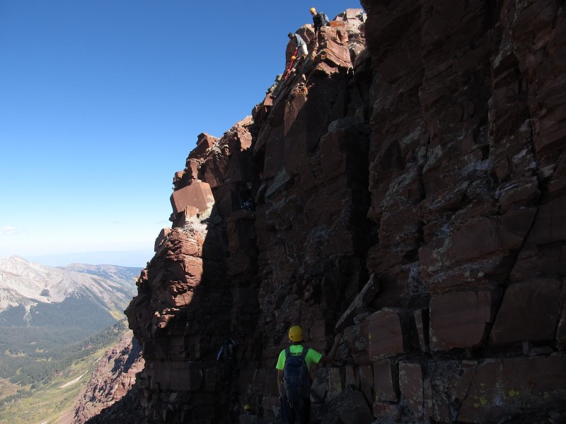
It was me, Tyler, & Heather as a trio following three guys, a father & two younger boys who were more equipped w/ this terrain than we were. We followed them on the down climb to the top of the Bell Cord, which involved interesting maneuvers on Class 4 terrain. Much of the hard sections were about midway through, where it was a lot of climbing up, which of course was our plan since we didn't want to leave the top of the ridge. We even saw a plane that was making hard turns around the peaks, showing off a few times before heading back eastwards. I'd definitely be vomiting if I was riding w/ that pilot. Tyler descending to the top of the Bell Cord, followed by Heather.
This was more fun than terrifying for me. Ain't no turning back w/ each step forward. The hardest part was a section w/ two narrow chimneys, where there were a few holds where one awkwardly hoisted themselves up over a small protruding choke stone. Hardest section of the traverse, two vertical narrow chimneys.
The highest point along the traverse was close to N. Maroon than S. Maroon, where I took a panorama while the other climbers were one the last section where one had to jump over a dip. I took my turn & then followed the group as we slowly were the last ones to reach the ridge & gentle terrain to the narrow summit of N. Maroon. Wide angle shot from the highest point on the traverse. Summit party on N. Maroon. I think nearly all of us completed the traverse.
It sure felt good to do the traverse. I was hesitant about climbing it since the last time I was up S. Maroon on 8/11/10 was just a few days before there was a death near the Bell Cord as a father watched his 20 year old son fall 600 feet to his death due to falling rock from above. Kind of made me feel iffy about the whole thing, since my descent from S. Maroon on 8/11 was met w/ an unexpected thunderstorm which turned into a snowstorm. I had to huddle under a cleft at 13,500 feet elevation near the top of the two gullies for over an hour on the standard route as the weather turned dark, windy, & foggy. Made it down just find during a rainy clearing , though I slipped twice & bruised the palm of my right hand. I guess that's why the standard trek up S. Maroon didn't feel so long the first time, because I was distracted.
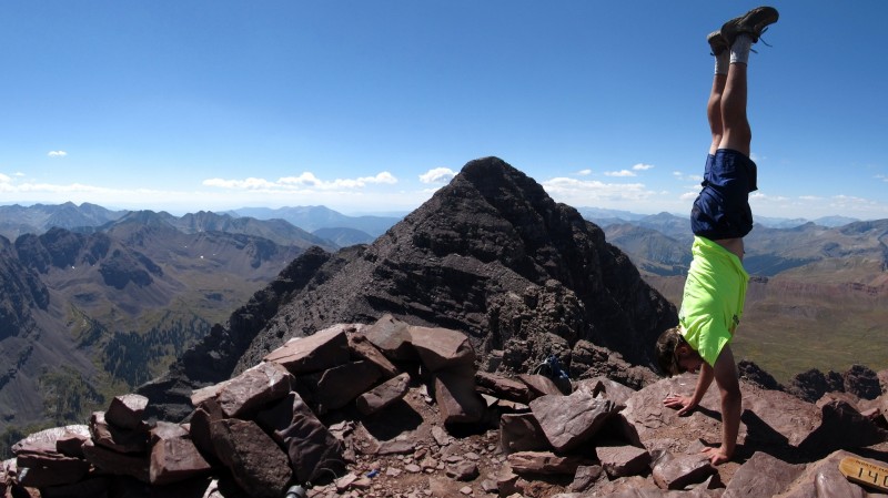
We waited till it was Tyler, Heather, & I at the summit before we got some quick photos. Then we took a relaxing descent down the standard way, stopping for photos of the dramatic steepness & beauty of the area. Maroon Lake had vibrant yellow colors below & Crater Lake was just a small muddy pond, if it was even classified as that. The water level was so low due to the dry winter season, though soon it would be a different story again. Our trio pose w/ S. Maroon in background. Tyler's summit handstand. The rock I found atop Pyramid's summit makes its new resting stop atop N. Maroon. Descending the gullies down N. Maroon. Colorful view down the Maroon Creek valley
Before long, we were at the trail junction at Crater Lake, where we parted from Heather & made it back to Site 7. We packed our supplies & ventured back to Maroon Lake where Tyler cooled off briefly in the lake, scaring off the photographers & old-timers. It was still quiet along the lakeshore, but in two weeks, it was gonna be packed w/ cameras & tripods. That was a primary reason in getting these peaks done w/ now rather than wait, since parking was going to be impossible. Back at camp. Admire Tyler's clean superb orange tent versus my blue homeless shelter hodgepodge. Aspen foliage near Sievers Mountain
When we got to the truck, we headed back to Glenwood Springs & east to Denver. It was a tiring drive, & we stopped at Qdoba in Dillon since Tyler left his watch there after a previous trip in the Mosquitos. I felt myself a little headachy from the concentration that I started dozing off. I didn't even realize I dozed off practically the whole way until we got back to where we met at Thornton. But from there, we headed off anticipating a future weekend of meeting up again in another part of the Centennial State.
Well, after a weekend full of hiking & not falling off the red rotten rock, I'm not feeling so great, so please excuse me while I head to the restroom to go vomit. Adios for now, until my next report!
Thumbnails for uploaded photos (click to open slideshow):
Your username made me look at this report! Great job, and a very refreshing perspective with cool photos of this trio. Keep them coming!
I dig the sphericals!
I'll admit the user name drew me in as well. I thought, ”Who in the world would have a username of VOMIT. ALL CAPS. I mean, really. Where is that vomit war emoticon? Really nice pics and very cool sphericals. I just skimmed the report but I'll be back when I have more time. Agree with the other posts. I'd like to see more reports.
Those are really cool. I noticed myself and my 2 partners in some of your photos as well! I believe I talked to you breifly on the summit of N Maroon and you guys must have gone down about 15 minutes after we did.
Hr011242, no problem at all that was such a fun day! Maybe we can do another 14er climb/traverse sometime.
Djkest, I remember you guys as well, particularly taking the pic of you three atop N. Maroon. Great report of the Bells on your blog, fantastic photos - excellent shot of that crazy airplane!
Caution: The information contained in this report may not be accurate and should not be the only resource used in preparation for your climb. Failure to have the necessary experience, physical conditioning, supplies or equipment can result in injury or death. 14ers.com and the author(s) of this report provide no warranties, either express or implied, that the information provided is accurate or reliable. By using the information provided, you agree to indemnify and hold harmless 14ers.com and the report author(s) with respect to any claims and demands against them, including any attorney fees and expenses. Please read the 14ers.com Safety and Disclaimer pages for more information.
Please respect private property: 14ers.com supports the rights of private landowners to determine how and by whom their land will be used. In Colorado, it is your responsibility to determine if land is private and to obtain the appropriate permission before entering the property.


 Classic Maroon Bells from the lake shot")
 Hiding the food up in a tree, which was an absolute fail when it came crashing down moments later. We later covered it w/ ro")
 The two hikers from Bosnia we met atop Pyramid")
 Found this rock at the summit. Says")
 Peering down the rock glacier in the amphitheatre & incredible backdrop.")
 Descending Pyramid")
")
 15 second exposure near Campsite 9 reveals the outline of Pyramid, the moon, Jupiter, & Orion.")
 Morning rise over the West Elks")
 Landscape contrasts. Elk 14ers in foreground, followed by Elk 13ers, followed by Sawatch 13ers, followed by Sawatch 14ers.")
 Summit of Maroon inspecting our traverse.")
 The start of insanity.")
 Tyler descending to the top of the Bell Cord, followed by Heather.")
 Hardest section of the traverse, two vertical narrow chimneys.")
 Wide angle shot from the highest point on the traverse.")
 Summit party on N. Maroon. I think nearly all of us completed the traverse.")
 Our trio pose w/ S. Maroon in background.")
 Tyler's summit handstand.")
 The rock I found atop Pyramid's summit makes its new resting stop atop N. Maroon.")
 Descending the gullies down N. Maroon.")
 Pyramid's backdrop. Can you spot Tyler?")
 Colorful view down the Maroon Creek valley")
 Back at camp. Admire Tyler's clean superb orange tent versus my blue homeless shelter hodgepodge.")
 Aspen foliage near Sievers Mountain")