Click here for the blogspot version of this trip report.

Maroon Bells on the hike in. Possibly the most photographed mountains in Colorado, why not one more?
Summary
Maroon bells climb ascent via the Bell Cord Couloir, Maroon Peak, traverse across the Maroon Bells ridge to North Maroon Peak, descent via Northeast Ridge.
Route

Our track is in dark red, as you can see we got off route on the descent. From the first photo you can see we had quite a bit more snow than shown in Google Earth, totally obliterating the trail. On the date of our climb, snow pack in the area was above 250%
Climbers
John

JMB
Maroon Ridge with Maroon Peak in the background. John has almost completed the 54 Colorado 14ers, half of the US State high points including Ranier and is on his way to completing all the Boulder County high points.
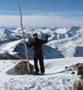
Rick

Me, On top of Maroon peak feeling not so great at over 14K feet after hard rock scrambling in crampons to gain the summit. Now 40, I don't get out much these days due to having small children and I was probably not in the best shape for this climb.
Stats
2.1 mi., 685' eg. hike to camp
8.8 mi., 5058' eg. summit day
8:10p - 9:10p ascent to camp
Temperature at start 37F/3C
2:55a - 8:15a Bell Cord couloir climb
Temperature at couloir exit 39F/4C
9:30a Maroon Pk summit 14,156 Feet/4315 Meters 24th highest peak in Colorado
11:15a Bell Cord saddle
3:30p NM summit 14,014Feet/4271 Meters, not officially considered a separate peak
Temperature ~53F/12C
9:30p camp
10:45p TH
1 hr approach to camp
5.25 hrs Bell Cord couloir climb
3 hrs Maroon Pk climb (up & back)
4.25 hrs Bell Cord saddle to NM traverse
6 hrs Total S->N Bells Traverse
6 hrs descent from NM to camp
1.25 hrs hike out
The Hike In

Packing up our gear in the parking lot.

John snaps some photos on the way in while locals and tourists alike enjoy the evening by Maroon Lake

John hiking through the forest
Bivy
We arrived the night before after driving 3.5 hours from Denver to the trailhead. We stopped at a subway in Leadville and bought sandwiches to eat at the trailhead. We were then going to use the long day immediately after the Summer Solstice to hike to Crater Lake and bivouac for a 2am alpine start, the moon was set to rise at 1:55am, about a 1/3 moon.

John Found a perfect level grassy spot for our bivy, I slept like a baby in my bivy sack.
Climb
As John kept reminding me, the climb we were doing was a combination of several routes and had 4 distinct phases each with their own charachter.
This climb was characterized by straight ahead snow climbing for 3,600 feet/1100 Meters. We both brought 2 ice axes and were glad to have them. For so much time in the snow we were able to vary our technique on the steeper terrain and avoid fatigue on isolated muscle groups. We did some traversing on lower angle snow down low then brought out our second tool and used them dagger style and then alternated between that technique and plunging shafts.

John working his way up in the dark, as soon as we hit the snow we were able to turn off the headlamps and use the moon to light our way. We stopped in a flat spot with willows to put on our crampons.

There is nothing like the rush of sunrise in an alpine setting pure energy, all smiles.

John lining up with the Bell Cord. Alpenglow hitting the peaks. Most of the way up we had perfect cramponing snow which softened as the sun came up. We were able to kick steps when we exited the couloir.

Me measuring the slope by placing the slope card on the shaft of my mountaineering axe. The lower angles I measured were around 35 degrees the highest was 43. Generally the slope seemed to be at around 39 degrees in these conditions. I am full of energy and excitement as the sun is coming up, that expression on my face will soon change as I gain higher elevation.

The runnels looking up the couloir formed by falling rock and ice. You can see rocks lying in the snow. Soon after this photo we got to the left side of the large runnel which was about 5 - 6 feet deep. Rocks and ice chunks began to come off the wall on the North side, they would bounce down towards us and the runnel would capture them. Both of us were climbing a little slower as we always had to keep an eye on the crumbling mountains above.

John has a natural talent for photography. The photos in this blog are a mix, most of the good ones are his.

John exiting the couloir.

My weak attempt at staging a dramatic couloir exit photo swinging my ice axes. Pyramid Peak, another 14er, is behind me.

Exhausted after the long snow climb I took break in the saddle on top of the couloir and tried to cool off. The smile from the earlier photos is gone.

Looking from the saddle facing west, phase 1 is complete, over that side is where our route goes next.

This phase of the climb involved relentless scrambling and steep hiking over loose scree while wearing crampons and carrying ice tools due to the conditions. I even found myself doing some 4th class dry tooling simply because I had the tool in my hand. After the Bell Cord Couloir I was pretty tired, gaining this summit made me almost want to call it a day.

Loose Scree on the west side of the Bell Cord Couloir saddle.

We had to traverse this steep snow field from the saddle to start our ascent of Maroon Peak. The snow was very firm since it is out of the morning sun.

The beginning of the ascent involved very loose scree and hard snow.

The route up Maroon Peak

Me scrambling.

John getting to work, rock scrambling in crampons is a lot of work.

Me exhausted, stumbling to the top of Maroon peak. Maroon Ridge and North Maroon Peak, Phase3, sits in the background. I wasn't sure at this point I would have enough energy left over.

John on the Maroon Peak summit with Snowmass Mountain 14,092 Ft/4295 Meters in the Background.

Looking towards Crested Butte. Hometown shot for my mom.

Mt Crested Butte ski area.

John descending Maroon Peak.

On the way down I knocked this boulder loose. I yelled "rock! rock! rock!", this thing really picked up speed, John tried to jump over it, it skipped off a rock, went airborne and hit him in the knee while he jumped. In hindsight we were a little tired and simply were not taking the rock fall hazard seriously enough. You can bet that changed.

It took John a while to recover from the impact, we were not sure at this point whether he would continue but eventually shook it off. It did slow him down and I am sure caused a lot of discomfort.

Climbing back to the Bell Cord saddle.
It was a big relief to remove our crampons and look forward to the scramble on mostly dry rock. There were a few 5th class sections so we brought along a 30 Meter / 100 foot light rope ( 8 millimeters ) and a small rack of protection.

Looking up 4th class exit of the saddle.

Me climbing out of the saddle.
The climbing was great, the rock was very solid where it needed to be.

Here is another Gendarme or tower. It looks improbable at 4th class but you can see the right leaning ramp that goes to the top. The climbing here always looks harder from a distance, it makes dramatic photos.

Here you can see one of the Gendarme bypasses on the left. I have no doubt that most if not all of the 5th class climbing could be avoided by leaving the ridge at times. It would take good route finding and a less aesthetic line. Snow on the sides of the ridge made it an unattractive option for us. The first very short 5th class was lead by John free solo with a spot for me, pretty ballsy. He then lowered a toprope which I gladly accepted.

This was our second 5th class pitch which I lead, it went at 5.3.

That was our longest roped pitch. Looking down... excellent exposure!

This was the hardest pitch at 5.7 taking the ridge on directly and pulling around a small roof. We chose this short pitch over a much easier but longer route to the west. The 5th class pitches protected well. Tricams from brown to orange seemed to go in solid everywhere but I wish I had my 0 and 00 Metolius cams that day. Most cracks in the mud/silt/sand stone were too even and smooth for nuts and the knifeblade pitons should have stayed home.

The prow in the background sits above a gap in the ridge that John wanted to jump into. The normal way around had snow leading to 2000 foot drop. I did not like the idea of jumping so suggested some belayed snow travel.

This was the alternative to jumping, we ran the rope between some boulders for friction and a toprope orientation. Natural protection, worked great.

My belay of the gap, I had an excellent groove to brace both heels and good rope drag. Nice shot of N. Maroon in the background, our destination.

John wanted me to lead that tower. "In hiking boots? Are you crazy?". I set up a solid belay anchor for traversing the snow on the right side.

It turned out this section of snow was short when we turned the corner. I was able to climb over a snow bank and into a dry notch area where the snow curves downward in the middle of the photo. A short scramble regained the ridge proper.

Exiting the ridge to the talus on the left, it was nice to have a longer stretch of walking terrain.

Headed up N. Maroon.

From a distance it looks a lot harder, once you see it up close you realize it is relatively easy scrambling.

John on North Maroon summit with Maroon in the background and the ridge below. On to the final phase, our descent.
The Northeast Ridge is one of the harder standard routes to gain a 14er summit in Colorado. The name is a little misleading because it only follows the ridge at the top, then descends a gulley/face to the south of the ridge and then exits crossing where the ridge fans out into 3 or 4 smaller ridges. In this exceptional late season snow year, starting out we were post holing up to our thighs. With the trail mostly covered in snow, route finding became an issue. We used every tool in our arsenal, maps, beta printouts, gps way points and compass bearings. We managed to stay on route most of the descent only getting off route by choice which ended up costing us extra time.

The top of the ridge rolls over in such a way you cannot see the ridge line below, with some trepidation we set off.

Once we got going things didn't look so bad and it felt like we were moving at a good pace.

There were a couple of interesting sections of the ridge.

It eased up again until cliffing out at the rock formation below, that is where you leave the ridge to the east face/gulley.

After scrambling down a ledgy cliff, we encountered more snow. John chose to turn around and kick steps, I preferred to faced out and plunge my feet. Notice the ice under the snow at the bottom of the photo.

The rock scrambling on this trip was relentless, we have been at this for about 13 hours at this point. John's was experiencing some swelling in his knee but he worked through the discomfort in excellent style.

John looking back taking a photo of the lower part of the gulley/east face.

Down low on the gulley/east face we were picking up faint signs of the trail. The exit onto the ridge "fan" is the rocky ridge to the left. The trail is on the lower edge of that snow field, mostly covered.

Here I am picking a path below the snow covered trail above. Again it looks difficult but it went really well.

Route crossing the ridge "fan".

Looking down from the traverse at some steep snow fields

Although tired, I was actually feeling pretty good, we were moving fairly fast to this point, descending and gaining richer air, plus it was beautiful and I could see the end in site. Maroon lake down valley is where the car is parked.

If you look in our gps track in the Google Earth image, this is where our dark red track gets off course from the red track where we supposed to be, we knew the way out was a traverse but there was an enormous snow field to cross, we thought we could find a dryer alternative.

At the bottom of the snow field we did some glissading to save walking. This is the stair step pattern in our gps track which committed us to a more difficult end to our day.

This was our last picture of consequence, we were not in the picture taking mood at this point. We were cliffed out, we had to escape below this waterfall. We spent several more hours skirting a cliff band you can see in our gps track. We were bush wacking through willows and dense pines as dark was starting to arrive. I became very impatient at this point. When we arrived at the car, we had long since run out of water, we had dry and sore throats, dry cracked lips, my boot gaiters had fallen around my ankles and my clothes were covered with pine tar. Regrettably we didn't take any photos, we just wanted out of there.
|