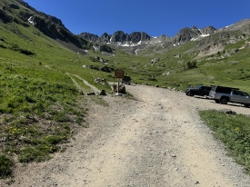
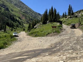
6/19/2020 Posted On: 6/19/2020 By: CougarOwl+53 Info: Just a question about road size in the final stretch to American Basin. Is that road wide enough for a full sized pickup, or would I be better off bringing my family up in a smaller, more maneuverable Ford Explorer? I would prefer the full sized as I would be bringing my daughters and the extra room would be useful. Thanks. New to this site. It is amazing and is answering most of my questions. | 1 |
|||
6/14/2020 Posted On: 6/15/2020 By: Rcole Info: The upper parking lot in American Basin is clear and open. The route from Ouray (Corkscrew, California Pass, Animas Forks, Cinnamon Pass) is clear and in good shape. | ||||
6/1/2020 Posted On: 6/2/2020 By: mtnmaneric Info: The road to Cinnamon Pass is open, including the turnoff to American Basin, however there are a number of large snowbanks covering the road up to the upper TH. | ||||
5/21/2020 Posted On: 5/21/2020 By: Squirrellysquirrel Info: A rogue individual cut the bolt to the American Basin TH earlier last week allowing a moderate amount of traffic into the area. Hayduke does indeed live in the hearts of others, you could say. I've been informed that opening this area is an orchestrated event with the S San Juans to ensure that all roads are contiguous from one side to the other so that if someone is in an OHV, they won't get stuck without gas or encounter a post-winter, gnarly road experience. American Basin closure has since been rebolted and will be closed until probably June 1 (it's usu opening date). Double check status today: it's indeed closed and the campgrounds that surround are packed to the gills. | 4 |
|||
5/20/2020 Posted On: 5/20/2020 By: Tim A Info: Gate just above Grizzly Gulch still locked for snow clearing. Walked the road to the American Basin/Cinammon split and its 100% free of snow so the county may open it any day. Creek crossing manageable on foot. This does add 4 miles each way and about 1000 of extra gain to any climbs of Handies or American peak. Did not go further into American basin than the 2wd th where continuous snow starts. The north face couloirs on American are in. Did not climb today so cant comment on snow quality. | 1 |
|||
10/12/2019 Posted On: 10/13/2019 By: sunny1 Info: Dry. No show or ice to contend with on the roads or on Handies & 13,795. 4WD & clearance are necessary to get to the upper TH. There is parking 0.2 mi below, saw a Subaru and a few trucks parked there. | ||||
9/26/2019 Posted On: 9/26/2019 By: wolfgangstiller Info: Cinnamon Pass Road is clear from Lake City to American Basin TH. Parts require high clearance. Last .9 mile to TH is 4WD but a high clearance 2wd could make it to the turn off. | ||||
8/28/2019 Posted On: 8/28/2019 By: Dayute Info: Made it to TH in stock 4wd Tacoma. Big shelf near top of the hill looks like a low-clearance killer. I'd park at the creek crossing if you don't have the clearance. Attaching a pic. | 4 |
|||
8/7/2019 Posted On: 8/7/2019 By: DixieFlyer Info: Per Hinsdale County Office of Emergency Mgt: CINNAMON PASS/CR 20 UPDATE Road closures have been moved from the summit of Cinnamon Pass to below American Basin. American Basin is accessible by driving over Engineer Pass (CR 20 from Lake City). | ||||
8/4/2019 Posted On: 8/4/2019 By: kevidently Info: This info affects multiple peaks/trailheads, so sorry if you see this posted multiple times, just wanted to share some info about County Road 30. We hiked Redcloud & Sunshine on Sat 8/3. Some rain had started just before we got back to the car around 130p. As we drove down CR 30 the weather got worse. Nothing like being on a narrow exposed mountain road that is covered in running water, with lightning and hail all around, and baseball sized rocks rolling onto the road. We got through it but just barely, apparently about 15 minutes after we got through several rockslides came down and people were trapped between the slides and also trapped up above closer to Silver Creek TH. I know they sent up excavation crews and were able to clear out some of the road, and some people were able to get down the road that night, but I still don't know what happened to the people further up (anyone have info?). Anyways, as of Sat afternoon there were emergency crew and sheriff blocking traffic from going up CR 30, but not sure about current conditions. You may want to call ahead before you head out that way to make sure trailhead access is OK. | 1 |
|||
7/22/2019 Posted On: 7/25/2019 By: davidboron Info: Be prepared to tromp thru some slushy snow fields. Some areas are hard packed and you can walk atop the snow, most are slushy. Clamp-ons not necessary unless you're more comfortable with the sure footedness. Route clear above 13000. | 3 |
|||
7/18/2019 Posted On: 8/27/2019 By: HikerGuy Info: Hiked American, Jones and Niagara from 2wd TH. Drove road with Hyundai Santa Fe. The worst part of drive in is the pot-holed pavement section around Lake San Cristobal. The shelf road portion of the road is in great shape, in fact the road is good shape all the way to the 2wd trailhead which is just past the Cinnamon Pass turnoff. Road is clear and dry with evidence of avalanches everywhere. It looks like every slope slide this past spring, just amazing. Two large slides have covered the road to the 4wd TH. You can cross the creek and park (I did not), but can't go much further than that. Snow bridge was still in place below the creek crossing. If that one melts out, you can hike up further to another snow bridge in order to avoid wading the creek. Photo 1 - View from creek crossing, space for parking on other side, road blocked couple of hundred yards beyond. Photo 2 - Snow bridge between 2wd parking and creek crossing. Still solid. Another bridge is further up. Photo 3 - First snow slide remnant covering 4wd road. Photo 4 - Second snow slide remnant covering 4wd road. Photo 5 - View of American Basin from atop American Peak. | 1 |
|||
7/10/2019 Posted On: 7/11/2019 By: Boomer68 Info: Did Handies via Grizzly Gulch yesterday. Afterwards drove up to American Basin. Made it about 50 feet past first creek crossing and hit a large snow field. Not possible to go any farther. Note, it looks there is still way to much snow to do this route without spikes/snow shoes. | 3 |
|||
7/7/2019 Posted On: 7/7/2019 By: angry Info: Small stream crossing around 10,800, looks deeper in the dark than it actually is but is easily passable. Made it to bottom of American Basin road at 11,300 in a Honda HRV. | ||||
6/24/2019 Posted On: 7/2/2019 By: hikebikeboardrocks Info: This was closed as of 6/24/19. I saw CFI and other crews at the Silver Creek / Grizzly Gulch trailhead and they didn't seem like they had any plans at all for opening the trailhead. It's covered in avalanche debris. | 1 |


