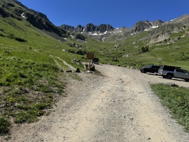
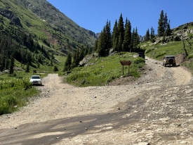
6/7/2025 Posted On: 6/7/2025 By: MountainBuhn Info: Huge snow slab right after creek. Going to need a week or two to melt this down. | 2 |
|||
6/4/2025 Posted On: 6/6/2025 By: yardman Info: The road to the actual trailhead remains pretty choked with snow. A few cars can park in the small pullout immediately past the creek crossing. | ||||
5/30/2025 Posted On: 5/30/2025 By: Youngan Info: American Basin road open off of cinnamon pass until 50ft past the stream crossing where snow is covering the rest of the road in American Basin. Made it up to the stream crossing in a RAV4. | 2 |
|||
5/21/2025 Posted On: 5/21/2025 By: BillMiddlebrook Info: The Cinnamon Pass road is open to Cinnamon Pass but the spur road into American Basin is not yet open. This means you can now get within a mile of the trailhead. | 4 |
|||
7/27/2024 Posted On: 7/29/2024 By: E_A_Marcus_949 Info: After Grizzly Gulch/Silver Creek it gets rougher. Any vehicle with some clearance can make it to the second creek crossing. There is plenty of parking there. I took my stock 2018 Subaru Forester up to the upper American Basin TH. I think a 3/6 rating is accurate, and you should have some offroad skills to drive past that second creek crossing. There are some sharp rocks and some spots that require careful maneuvering. I saw an Outback at the TH + the usual 4Runners, trucks, jeeps. It took about 40min from Grizzly Gulch to reach AB TH and about 90min back to Lake City. | ||||
7/22/2024 Posted On: 7/23/2024 By: Khieras Info: From Lake City to the start of the shelf road is smooth, easy, high-speed dirt. The shelf road through the Grizzly Gulch/Silver Creek trailhead is rough 2WD, but almost any car should make it without difficulty and without any real skill needed. From the Grizzly Gulch trailhead to the creek crossing just beyond the Cinnamon Pass turnoff my stock Forester made it, though slowly, with the only real challenge being a drop in the road about 1/2 mile in. Any 4WD/AWD should make it with a basic skill level. Didn't drive to the upper trailhead but it did not seem too bad, though you definitely need more skill or great clearance. | 1 |
|||
7/12/2024 Posted On: 7/13/2024 By: overthe59hill Info: I drove our Nissan Frontier pickup the day before our hike up Handies Peak to get a preview of the road. I got to the top trailhead with 4-low, but didn't like one short, rocky stretch. We encountered another truck coming up on our way down. I did not get to take the line I preferred and went a little to the right to make room, and heard our truck hit a rock. It's okay, no damage done (we don't have a skid plate). The muffler and everything else is okay, but I didn't want that to happen again, and I decided to park at the lower trailhead the next morning. A regular 4WD can get to the lower trailhead. | ||||
7/7/2024 Posted On: 2/12/2025 By: BillMiddlebrook Info: Road is dry and in summer conditions. The upper stream crossing (~0.7 below trailhead) is manageable for most AWD/4WD vehicles and there's parking just after it, before the road gets much worse. | 1 |
2 |
||
6/7/2024 Posted On: 6/7/2024 By: MountainBuhn Info: Two significant snowfields that make it so you have to park .5 from main TH. Photo shows someone tried to get up main road (fine), then tried to drive onto tundra to get around (dont do this). Will be good to go in 2 weeks or less. | 1 |
1 |
1 |
|
5/30/2024 Posted On: 5/30/2024 By: COnaive Info: We drove over Cinnamon pass this past weekend, the road from Lake City to American Basin turnoff was basically in summer conditions, we even saw a newer Malibu most of the way to the turnoff. For the pass itself, there were 3 foot drifts from Saturday night on the upper west side of the pass in places, which made the return trip on Monday interesting and required some shoveling. I'm guessing these drifts are pretty well gone at this point though. We also had to saw through a couple logs above the turnoff on the way back. In short, if just going to the turnoff, expect normal conditions, if going over Cinnamon pass, it would be a good idea to bring a shovel and even a saw. | 2 |
|||
5/22/2024 Posted On: 5/22/2024 By: ReginaThomas Info: Cinnamon pass is open from Lake City to Silverton so you should be able to get within 0.9 mile of the TH. Kiefer and I are headed up for American Peak tomorrow so will post conditions then and another update. | 5 |
|||
9/12/2023 Posted On: 9/14/2023 By: cpdas Info: Made it all the way to the upper trailhead in a stock Mazda CX-9 with no issues, a few rough spots along the way to grizzly gulch, then not so bad to the turn off for American basin but the toughest section forsure was in that last 0.75 miles to the upper trailhead. If you don't have high clearance I'd recommend parking right near the creek crossing and hiking that last 0.75-0.5 of a mile. | ||||
8/19/2023 Posted On: 8/20/2023 By: shwilsh Info: Road to Grizzly Gulch is much rougher than the stated 2WD starting around mile marker 10 - you need a stock 4WD. This continues to be the case all the way until the first stream crossing past the junction for Cinnamon Pass, at which point you will definitely need a high clearance 4WD to make it the remaining ~0.75 to the American Basin TH. We camped out just below the stream crossing and hiked in from there and on the way to the TH saw a larger SUV model of Subaru who had popped a flat on a large exposed rock halfway bw the stream and the TH. Didn't see the stated pull-offs just below the junction for Cinnamon Pass when we drove in in the dark but there is room for a half-dozen cars or so between the junction and where the road gets nasty. | ||||
7/26/2023 Posted On: 7/28/2023 By: kritifer15 Info: Made it to the upper trailhead in a GMC Yukon (Somehow). Turned on 4WD 14 mi. down CR 30. The only bad spot for us was .1 mi. before the upper trailhead. We had to get out and spot my dad to help him avoid hitting the oil pan. Excellent summer conditions at the trailhead with wildflowers blooming. | 1 |
|||
7/6/2023 Posted On: 7/7/2023 By: zmokrycki Info: I saw the other post about taking a stock outback up here, so I felt the courage to brave it in my slightly above stock crosstrek- Falken wild peaks and skid plates. Didn't have any issues getting up there. I did jump out of the car to scope the line before sending it. It should be noted there are TWO creek crossings to get to the TH, but neither one was an issue. I made it up the American basin creek and then found a campsite 3 or 4 spots in, though I probably could have made it to the top- I figured I'd pushed my luck enough. |


