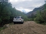
8/17/2014 Posted On: 8/20/2014 By: BillMiddlebrook Info: The Jennings Creek "trailhead" is still unmarked but it provides access to Tabeguache's West Ridge route which is NOT the route that was closed back in 2003. Just after the Angel of Shavano campground, there's a sign which states that Jennings Creek access to Tabeguache is CLOSED but this refers to the old route which went up the southwest ridge, not the west ridge. | ||||
5/10/2013 Posted On: 5/13/2013 By: GregMiller Info: Snow and mud turned around a subaru outback about 2 miles from the TH. If you have more ground clearance and/or knobbier tires, you‘d probably be fine. If you don‘t have more ground clearance, keep an eye out for some flat, light colored rocks in the middle of the road about 1.5 miles up from the Angel of Shavano trailhead - I knocked a hole in my exhaust on the way down, so you might want to roll them out of the way. | ||||
11/27/2012 Posted On: 11/27/2012 By: flintster Info: I just called the Salida Ranger district and the road is open again - and the speculation was that it was very dry. Will stay open all winter for cross-country skiing and snowmobiling they stated. | ||||
8/13/2012 Posted On: 8/13/2012 By: Vinegaroon Info: 240 is closed from just West of Angel of Shavano Campground/Trailhead to it‘s terminus at Billings Lake (past North Fork Reservoir/Campground) until October 1, 2012 or until FS Order 12-14 is rescinded. Until that time the Jennings Creek Trailhead is inaccessible... Too bad, as I was planning a hike up Jennings Creek to the West Ridge (between Carbonate Mountain and Tabeguache) in an effort to knock out Tabeguache Peak in early September... Guess that hike will have to wait. http://www.fs.usda.gov/Internet/FSE_DOCUMENTS/stelprdb5380091.pdf | ||||
8/5/2012 Posted On: 8/5/2012 By: mtnkub Info: The road is CLOSED as of 07/29/2012; anticipated reopening was not posted. Closure starts just past the Angel of Shavano campground (i.e. ~3.8 mi from trailhead) and includes foot traffic. The closure is apparently for logging operations in the area. | ||||
6/10/2012 Posted On: 6/10/2012 By: Cruiser Info: The dirt section of the road past the Shavano campground is in good condition. It‘s rocky and bumpy but I wouldn‘t be surprised if a (very carefully driven) Subaru could make it to the old trailhead. There‘s a little water running down the road in places but it‘s nothing to worry about. There are a few very nice camping spots below the trailhead too. One of which is only about 3/10 of a mile away from it. Bill‘s GPS coordinates were right on for me as well. | ||||
5/28/2012 Posted On: 5/29/2012 By: djkest Info: Lots of downed trees have been cut, road is completely dry. You might have some fun dodging fallen rocks and some cut trees but otherwise should have no problems getting to the trailhead. Bill‘s GPS coordinates were spot-on and I recommend putting these coordinates in your GPS to find the trailhead. The road gets wider on both sides for about 30‘ right at the trailhead, and there are a bunch of very small tree stumps at the beginning. | ||||
4/21/2012 Posted On: 4/24/2012 By: Boggy B Info: The downed trees have been cut and the road is easily drivable to snowline a little over 10600‘, about 1/3 mi past Jennings Creek. Looks like it was quite an effort, and the drive through the carnage is pretty unique. Stock FJ Cruiser and Tacoma had no problems. Snow above 10600‘ was super deep (3‘+) but melting fast so who knows... | ||||
11/26/2011 Posted On: 11/28/2011 By: wbarnett Info: A huge windstorm two weeks ago left dozens of downed trees on CR 240. We couldn‘t drive more than 0.6 miles past the Angel of Shavano campground, which is at least 6 miles from Billings Lake. Snowpack wasn‘t bad though. Up to 6 inches in some spots on the road. I hiked up to the North Fork Reservoir and then turned around. | ||||
11/11/2011 Posted On: 11/13/2011 By: SnowAlien Info: A lot of fresh new snow starting 0.4-0.5 miles after Angel of Shavano campground, making the road impassable unless in a serious 4WD (saw one Toyota Tacoma beyond that point). Had to park my Forrester and hoof up 3+ miles to the Jennings creek TH. | ||||
9/25/2011 Posted On: 9/25/2011 By: Neil Info: Dry and in good shape to the Jennings Creek TH for Tab. 4WD not required. Saw one Outback and what looked like an old-school Lincoln or Caddy...nice! Two cars can park at the TH, with additional parking less than 100 yards up and down the road. A number of great camping spots beyond Angel of Shavano TH closer to the Jennings Creek TH. ANGEL OF SHAVANO CAMPGROUND CLOSED FOR SEASON. | ||||
11/20/2010 Posted On: 11/21/2010 By: ColoradoSherpa Info: The road has some ice and about 3 to 4 inches of snow, but has packed tracks that make driving it easier. I was able to arrive at the Jennings Creek trail head without any problems in a stock 4wd. | ||||
11/7/2010 Posted On: 11/8/2010 By: mattpayne11 Info: Snowy and icy up higher, but still pretty accessible to 4WD vehicles. | ||||
10/30/2010 Posted On: 10/31/2010 By: tmathews Info: Made it to the TH in 4WD. The road is icy and snowpacked in spots, but totally clear in others. Used the TH to go up the west ridge of Tab, NOT the closed route. | ||||
9/18/2010 Posted On: 9/19/2010 By: 14erkid Info: Road has mud and water in a few spots. The road is fine though. I saw a VW eurovan make it just fine to the TH. |


