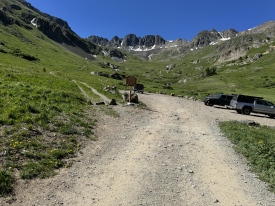
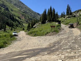
3/2/2021 Posted On: 3/3/2021 By: RWSchaffer Info: The road to the trailhead is closed at a winter closure gate about nine miles below the trailhead (picture 1). The first half mile beyond the gate is plowed and dry to allow workers access to a road drainage construction project. The next mile or so alternates dry patches with shallow, supportive, crusted snow. Farther along the road, snow becomes deeper, more continuous and less supportive. At the Silver Creek / Grizzly Gulch trailhead, snow is a good foot deep and mostly not supportive, consisting of a few inches of fresh snow atop a base that collapses almost all the way to the ground when stepped on in snowshoes. Farther along the road, snow continues to increase in depth, but also becomes more supportive again. By timberline, snowshoes no longer posthole. Still, marginal supportiveness makes travel slow and arduous for the first two miles beyond the Silver Creek / Grizzly Gulch trailhead. Also above the Silver Creek / Grizzly Gulch trailhead, the road is frequently marked by tall sticks wired to T-posts (pictures 2 and 3). This was really useful for following the road, especially in areas that had been obliterated by the avalanches of '19. | 3 |
|||
11/26/2020 Posted On: 11/26/2020 By: Squirrellysquirrel Info: Cinnamon pass is closed for the season. | ||||
11/17/2020 Posted On: 11/17/2020 By: Squirrellysquirrel Info: Heard from some hunters that American Basin is accessible. Roads proved too muddy with snow melt and with rock slides, did not attempt in a Subie Crosstrek. 4WD recommended assuming its accessible. | ||||
9/30/2020 Posted On: 10/3/2020 By: HikesInGeologicTime Info: Summer conditions. Made it to the American Basin turnoff in a 2015 Subaru Outback with M/S tires that are 57,000 miles into their estimated 60,000-mile lifespan, then proceeded up and over Cinnamon Pass. Having a spotter was very helpful for the last half mile to Animas Forks, if anyone wants to take a shortcut to or from 550. | ||||
9/8/2020 Posted On: 9/17/2020 By: Jnaffy Info: Easy road. Only one spot that takes any knowledge of lines. Never needed 4wd. Stock wrangler | 1 |
|||
8/22/2020 Posted On: 8/25/2020 By: kspitzer1987 Info: Took a stock F-150 with crew cab and long bed up this with no issues. As long as you have a decent idea what you're doing off road, you'll have no issues in something with good ground clearance. Shorter wheelbase will be of benefit on this trail, but even with my long wheelbase, I didn't scrape, though I did have to carefully choose my line a few times. Stream crossing is very minor and any vehicle can make it across. Fun drive up from Lake City, but definitely DON'T try this road in a car. Unless you're coming from west of Handies, ignore google maps if it tries to take you any way other than the directions on 14ers.com from Lake City. Follow the 14ers.com directions and you'll be golden. | 1 |
|||
8/16/2020 Posted On: 8/16/2020 By: barryfagin Info: The instructions to the trailhead are exactly right, trust them and you'll be fine. Ignore Google Maps if it tells you something different. Pavement ends on County Road 30 after five miles or so, turns to gravel, then pretty dramatically turns to 4WD as you pass through some sort of abandoned quarry or construction site. The last seven miles are pretty rough. Took me about an hour and a half from Lake City. I made it to the trailhead in my 4WD Subaru Impreza, but I wish I hadn't attempted it as I bottomed out a few times, desipte being as slow and careful over the tricky spots as I could. I saw cars parked at the American Basin turnoff that were even less suited to the road than mine, but I still regret the decision. Maybe I'm just more hung up about the condition of my car than they were. Remember that 4WD for a trailhead designation also implies the need for high clearance. Another inch or two on my car and I would have felt a lot better. Next time I'll rent a jeep in town or something more off-roadish from a rental car agency. Conditions at the trailhead were excellent, given the concerns above about getting there. I arrived at 0730 to find plenty of parking, dry conditions. | 1 |
|||
8/4/2020 Posted On: 8/9/2020 By: jordanthebuff Info: Definitely need highish 4WD, but this road is no worse than other 4WD roads to 14er trailheads. Its about 4 miles from the Grizzly Gulch/Silver Creek trailhead to American Basin and the cutoff is very obvious. We ended up parking just after turning onto the American Basin road. We could have driven all the way up, but we were looping the Handies southwest slopes and the east slopes, so we'd need to get back to the car eventually anyways. If your car can make it up to the American Basin road, you can make it too the trailhead. Neither creek crossing (first on the CR30 and second on the American Basin road) was deep and could be passed in any vehicle at this point in the summer. I though the toughest sections of road were about 1/2 - 3/4 mile past Grizzly gulch and then again about 1/2 mile before the American basin road. I was driving a stock 2016 Nissan Rogue and I would say any Subaru or crossover/mini SUV could make it to the trailhead. I would say this road is comparable to the Mt Huron road above Winfield. There is some great camping in and around the Grizzly Gulch TH. We found a spot 0.4 miles past there. If you are only doing Handies, then you could camp closer to the American Basin TH as there were plenty of spots the entire length between Grizzly Gulch and American Basin THs. | ||||
8/1/2020 Posted On: 8/1/2020 By: Schuck Info: Question - can I make the drive on CO 30 from Lake San Cristobal to the lower trailhead in a Honda Odyssey? Don't have our Suburban on this trip and not sure how far I could get in the van. Plan to drive to the lower trailhead and hike the extra ~1 mile to the upper trailhead, if possible. | ||||
7/30/2020 Posted On: 7/30/2020 By: mwhat Info: Directions on the trailhead page are from Lake City. Are Google Maps directions accurate, if coming from Silverton? | 3 |
|||
7/27/2020 Posted On: 7/27/2020 By: Tim Fab Info: Does anyone know what to expect from the road condition this Tuesday afternoon 7/28? Given all the rain and the flash flood warning issued for Monday I am wondering if the road is at risk of wash-outs or if the creek crossing will be too high for a Subaru. | ||||
7/13/2020 Posted On: 7/13/2020 By: aseamans Info: Just a question: how does the route look going up 30 from Lake City to the TH? Is the creek at Cleveland Gulch pretty nasty or doable? We have a stock 2011 Jeep Grand Cherokee and are looking to drive up there to do Handies. Any info or advice would be much appreciated. | 2 |
|||
7/11/2020 Posted On: 7/12/2020 By: E_A_Marcus_949 Info: I didn't drive this but walked it back from Handies TH to Grizzly Gulch. There are a few tough spots but saw one Subaru Crosstrek that made it to about 11,400'; the rest of the cars at the upper trailhead were trucks, 4runners, ATVs, razers, lifted SUVs, etc. Too many vehicles were parked on the tundra, grass, and flowers. Honestly most of the road was well maintained - if you know how to pick your lines you'd be able to make it somewhat far. The roughest part seemed to be near the upper trailhead. Attached are photos of the two creek crossing (horizontal is first; vertical is second, closest to upper TH - Subaru I mentioned before made it right past this second creek crossing). | 1 |
|||
6/26/2020 Posted On: 6/26/2020 By: Ugaboo4 Info: The trailhead is only 20 miles south of lake city but takes about 1.5 hours to get to the trailhead. Highly recommend 4 wheel drive. The first 10 miles are not bad but the last 10 are definitely off-road conditions. Once you take a left to approach the American Basin TH, there are plenty of spots to pull off and park. We had no problem crossing the stream yesterday. We have a Jeep Rubicon and has no problem getting to the end of the trailhead. Beautiful spot to camp. The views are breathtaking! Summer conditions! | ||||
6/20/2020 Posted On: 6/23/2020 By: hogantheepic Info: Drove up this road after dark on the 19th, couldn't tell where the actual trailhead was. Camped out, and in the morning, ended up hiking about a half mile to the trailhead. Everyone else besides 2 cars ended up parking where we were parked and hiked the extra half mile to the trailhead as well. Oops! Road should probably have 4WD only (they always say 4WD recommended for some reason) because there are some spots where you might have trouble otherwise. Also, high clearance would make it a lot safer for your car. |


