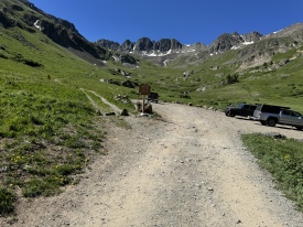
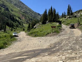
5/15/2022 Posted On: 5/15/2022 By: nsaladin Info: Road is clear of snow all the way to American Basin. Cinnamon pass has been plowed up to the summit and down to Animas Forks. Engineer is still not open from lake city side but should be soon. Cinnamon Pass from Lake City to Silverton is open. Shot towards Sneffels Range as #3 and some heavy machinery that was sunk 5 feet deep in mud as #2 | 3 |
1 |
||
5/14/2022 Posted On: 5/15/2022 By: bergsteigen Info: Was able to drive to the lower 4WD just over the stream crossing. Snow begins right afterwards. | ||||
5/14/2022 Posted On: 5/16/2022 By: CheapCigarMan Info: Two stream crossings. The second just below the 4WD TH is widest and deepest. Road is plowed and clear all the way to just past the second stream crossing. You are able to drive beyond the second stream but will soon encounter snow drifts. This puts you at about a half a mile below the end of the road, the 4WD TH. | ||||
10/19/2021 Posted On: 10/20/2021 By: john curtis Info: Several patches of snow (not deep) up to the Cinnamon Pass/American Basin split. American Basin is only passable to the 3rd pull-off. I parked my Jeep Wrangler at the second pull-off at 11,352 ft. Deep show drifts cover the road the majority of the way to the trailhead for Handies Peak. | 1 |
|||
9/22/2021 Posted On: 9/22/2021 By: -wren- Info: With careful line choice, I was able to make it up and down to the upper trailhead without scraping in a 2003 Outback (7.9 inch clearance, AWD). On the way back I had to get out and look more closely at a couple of the nastier spots that are more blind on the descent. Low gear was helpful on the descent to creep over the sharper stuff with extra caution. Backing up for another vehicle would be a huge pain in the ass in a similar vehicle and would definitely call for a spotter. Any car with 7+ inches of clearance should be able to get just past the creek crossing fine with 2WD. | ||||
8/20/2021 Posted On: 8/21/2021 By: Pedro F Info: FROM SILVERTON -- Google maps is accurate, at least from a routing perspective (2 to Animas Forks, 5 to Cinnamon Pass, 30 from Cinnamon Pass). Road is not too bad through Eureka; don't be fooled though, it gets a good amount worse after Eureka, becoming more like a 4 rating, IMO...certainly worse than coming the opposite way from Lake City. I was squarely in 10mph (sometimes less) territory basically the whole way from Eureka, so Google maps claim of 45 min Eureka-TH is optimistic. Regardless, it gets tedious dealing with that for some 9 miles straight. Downdrive from Cinnamon Pass to the TH was relatively easy. | 3 |
|||
8/14/2021 Posted On: 8/16/2021 By: wanderingsteve Info: I made it to the upper 4WD trailhead in a Subaru Outback without any issues. It did require a bit of careful driving beyond the lower trailhead and I would not recommend attempting with any less clearance. The toughest section is a mound maybe 0.25 miles from the upper trailhead (I went to the right). The creek crossing is easy in any vehicle right now. I think the 2WD road below Silver Creek/Grizzly Gulch is a fair bit rougher than last year. We got a VW Jetta up there last year without much trouble, but I would not attempt to drive that section with such little clearance right now. | 1 |
|||
7/22/2021 Posted On: 7/22/2021 By: Squirrellysquirrel Info: Hey everyone, quick update: the San Jauns are not in a happy place right now**, monsoons are upon us. Significant rock/mudslides in the American Basin area tonight. Hinsdale County EMS and SAR are on scene to recover 20+ persons. More rain conditions expected throughout the week, consider trails/roads suspect for travel in and out for most of the San Juan areas. I also encountered a mudslide north of Powderhorn with some noticeable force (driving a heavy duty ford 250), and then again south of town after the bridge: there was over-road flooding, definitely made you slow down. Recommend exercising caution, off-roads are sticky and can shift easily. **edit: or maybe the mountains are rejoicing? | 1 |
|||
7/20/2021 Posted On: 7/20/2021 By: tdurty Info: Made it to the very upper TH in a stock Subaru Crosstrek with AT tires. Only one spot that required a spotter and careful line choice. | 1 |
2 |
||
7/4/2021 Posted On: 7/4/2021 By: kimbuk2 Info: Driving 2016 Land Cruiser, no lift, 9.1~ of clearance with KO2 tires. Drove in from Silverton over Cinnamon Pass. No issues or clearance concerns. Some tight switchbacks but easily doable (with no reversing) with the right line choice. At American Basin proper, could drive up to 11,600 TH no problem, but any less clearance or lack of 4WD, Id recommend parking at the lot near 11,300 (only .5 miles away on the road). Water crossing was Subaru-able, no issues, low. | ||||
7/4/2021 Posted On: 7/7/2021 By: tstorm5 Info: INFO: 2017 Stock 4WD Tacoma with long bed (I sleep in it) 8 inches of clearance and K02's The road up to Silver Creek/Grizzly Gulch Trailhead is accessible by almost any vehicle if you follow the easy to see lines. Lots of potholes to dodge and a handful of larger rocks. Past that and on to the 11,300 Trailhead you will cross 3 creeks, the largest creek crossing is the last one and there is one large rock there that could ruin your trip. I stopped at 11,300 trailhead and walked up to 11,600 to see what was there. Glad I did. I love my truck to much to drive it up there. It could have easily made it but it gets pretty rough (large rocks) up on the last .5 mile of road. Everyone should see American Basin at least once in their life. Toughest obstacle may be dodging all the Razor traffic. | ||||
6/30/2021 Posted On: 7/1/2021 By: coffbrauhaus Info: Road is heavily potholed and has a lot of interesting obstacles if you don't have a 4WD vehicle. We made it to about a mile below the actual trailhead and shortly before the turnoff for American Basin in a sedan with 6.3 inches of clearance on 6/30, but I can't in good conscience recommend doing that unless you have an experienced off road driver with patience and a good eye for a line behind the wheel. Take the uphill line at the stream below American Basin, there's a pretty deep spot when you first cross it. | 1 |
|||
6/5/2021 Posted On: 6/7/2021 By: Kiefer Info: Cinnamon Pass is open both ways. Road is open to the lower parking area for American Basin. The stream crossing is roaring but a Subaru can still make it across. In another week, the upper 4x4 trailhead will be accessible. | ||||
5/23/2021 Posted On: 5/23/2021 By: tfrye Info: Conditions at the American Basin trailhead last weekend. | 1 |
|||
5/1/2021 Posted On: 5/4/2021 By: AlexeyD Info: Road is clear and drivable to the Cinnamon Pass junction. A bit of clearance and AWD/4x4 recommended as the road gets a little rough, especially in the last few miles. |


