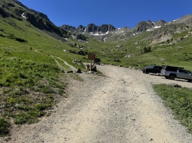
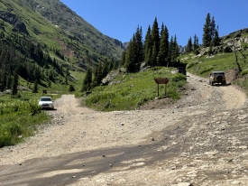
4/26/2012 Posted On: 4/27/2012 By: San Juan Ron Info: Clear all the way to the Lake Fork which is in American Basin and around 1/3 mile from the Cinnamon Pass Road. Only muddy and a bit of snow once you hit the trees which are roughly 1 mile from the American Basin turnoff. | 1 |
|||
9/25/2011 Posted On: 9/25/2011 By: coloradomojo Info: Drove up from Lake City 9/24. No snow or ice yet. Stream crossing ~3-4 inches. Above the stream its 4WD for sure. Below the stream I had my stock 4Runner in 4WD the last 1/2 -1 mile. Agree with other posts that suggest its atleast high clearance 2WD below the stream, but that being said, driving out today there was a Saturn wagon that had made it to the stream... | ||||
9/6/2011 Posted On: 9/9/2011 By: Bullwinkle Info: Attempted American Basin from Ouray, via US 550 (Million Dollar Road) to Silverton, then Rt 2 to Cinnamon Pass. Total transit to final west side ascent of Cinnamon Pass was 36 miles/75 minutes. Pass though the center of Silverton to the end of town, then branch right on Rt 2. The first 2 miles are paved, then 6 miles of excellent graded road, then 3.4 miles of rough 4WD road (11.4 miles total from Silverton) to the Cinnamon Pass marked turn-off. This where it gets interesting. Complete a short ascent to the level rest area. After this, the road is narrow, single track with a nasty, deeply rutted area about 100 yards above the level area below. Given the rental GMC Canyon 4WD (Chevy Colorado) I was driving, an all-day rain event, and the consequences of failure, I elected to retreat and try again another day from Lake City. The running ground clearance, approach, departure, and break-over angles; and the wide turning radius of this type of vehicle are not adequate for this route. Safe passage will require a true off-road, high ground clearance vehicle. BTW, off-road Jeeps are readily available in Ouray for $150, plus tax and gas. | ||||
7/2/2011 Posted On: 7/4/2011 By: Irish14er Info: Road open all the way to the TH (Summer). Need 4WD. Stream cross OK. When leaving the stream cross exit on the left side is a little more challenging - steeper due to a large rock hidden under water. | ||||
6/26/2011 Posted On: 6/27/2011 By: ColoradoSherpa Info: The road to American Basin is open and in good shape all the way to the stream crossing 0.2 miles after the American Basin/Cinnamon Pass fork. Beyond the stream snow banks block the road to the 4WD trail head, but shouldn‘t be long before it‘s accessible. | ||||
6/10/2011 Posted On: 6/10/2011 By: San Juan Ron Info: The road to the AB TH is plowed just past the creek (Lake Fork) in the basin. It's very muddy and there is still a lot of snow. The roads from Lake City and Silverton (Cinn. Pass) to the AB TH are both open. It's beautiful -- but muddy. | ||||
5/26/2011 Posted On: 5/26/2011 By: Rcizzle Info: The road to the Lower AB TH is now plowed. Looks like Hinsdale is getting pretty close to Cinnamon Pass. The upper AB TH is still buried under 2-3 ft. of snow so it may be a month or two before anyone can park there. The LFGR is also crossable right now as it is still buried under snow. The road is very muddy right now leading to the AB. | ||||
5/21/2011 Posted On: 5/22/2011 By: jmoney Info: While the road to AB was mostly clear of snow, the county has a bulldozer blocking vehicle access about a mile before the AB turnoff. Just speculating, but I would assume they‘ll move it sometime soon now that the recent snows have melted. | ||||
5/10/2011 Posted On: 5/13/2011 By: San Juan Ron Info: The CR 30 gate was unlocked on May 5th and the road is plowed to the AB turnoff. As of May 10th, the last 1/4 mile to the turnoff had slushy snow and was passable but slick. The spur to the AB TH was NOT plowed and had deep snow (6‘). The road from the AB TH to the top of Cinnamon Pass was just beginning to be plowed. SJ Ron | ||||
7/27/2010 Posted On: 7/27/2010 By: JB99 Info: I‘m not sure if the road has changed since the last update but I drove a Subaru Outback to the "4wd" trailhead without any problems. This was my mom‘s car too so I wasn‘t risking anything. If you drove to the 2wd pulloff then getting to the actual trailhead isn‘t much worse than what you‘ve already passed. Of course if the stream crossing is high then it could be a different story. | ||||
6/20/2010 Posted On: 6/20/2010 By: WSC_Geologist12 Info: The trailhead is good! There are two stream crossings that are about 5" or so deep. A couple of difficult vehicle moves if you have low clearance. Parts of the road are washed out near the Cinnamon Pass turnoff. I had no trouble getting to the trailhead in my GMC Jimmy, and it is relatively low. Just go slow. Also a nice side note: Hinsdale county is applying Magnesium Chloride to the road from where it is dirt until 1 mile towards the Grizzly Gulch Trailhead after you turn off. | ||||
5/31/2010 Posted On: 6/1/2010 By: Nathan Hale Info: Road is open to about the same point as the last update. The bulldozer is gone, so you can get a bit further, but the slide is still blocking things. At this point a bit of the slide has been plowed, but on the far side of the creek crossing there is still a major blockage. Unclear if they‘re going to plow it or let it melt out (there was no equipment anywhere nearby), but it will be a while before it melts out. Beyond the creek crossing there were only a few drifts before the upper trailhead and they‘ll likely melt out well before the slide debris over the creek crossing does. | ||||
5/23/2010 Posted On: 5/24/2010 By: highplaces Info: Able to drive down .1 miles past the turnoff to American Basin, there is a large parking area there. There was a bulldozer in the road blocking any attempts to go further. The photo is walking out towards the car at the end of the day. Beyond the bulldozer, there are remains of a recent slide in the road. | ||||
5/16/2010 Posted On: 5/17/2010 By: stevevets689 Info: Still about the same, road is open to roughly 100 yards from the American Basin turnoff to a turnaround. There were some big puddles and running water in places and the road is pretty rough, easily handled by my Jeep though I‘m not sure how lower clearance vehicles would do. | ||||
5/11/2010 Posted On: 5/11/2010 By: E-dorvs Info: Was there on 5/8. San Juan Ron update is correct. Wanted to add just a reference for others wondering about this trailhead. Got a Subaru Outback Sport (not a full Outback but the Impreza frame - 6.1" of clearance) to the turn off for American Basin without much problems at all. A few sections required careful placement but otherwise no major problems. |


