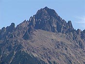
| Location ................................................... | In the Uncompahgre National Forest, 7 miles west of the town of Ouray, 4.5 miles north of Telluride and 14 miles northeast of Wilson Peak. |
| Nearby Towns ................................................... | Ridgway, Ouray, Telluride |
| Maps ................................................... | USGS Quads: Mt. Sneffels, Telluride
Trails Illustrated: #141 |
| Standard Route ................................................... |
| South Slopes | | Difficulty: | Easy Class 3 | | Trailhead: | Yankee Boy Basin | | Trailhead Elev.: | 11,350 feet | | Elevation Gain: | 2,900 feet | | Trip Length: | 6 miles | | Exposure: | Considerable |
|
|
