http://kwgn.com/2015/09/28/andrew-hamil ... supported/" onclick="window.open(this.href);return false;
Live interview this morning!
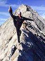
Andrew Hamilton - Nolans Unsupported 2015 attempt
Forum rules
- This is a mountaineering forum, so please keep your posts on-topic. Posts do not all have to be related to the 14ers but should at least be mountaineering-related.
- Personal attacks and confrontational behavior will result in removal from the forum at the discretion of the administrators.
- Do not use this forum to advertise, sell photos or other products or promote a commercial website.
- Posts will be removed at the discretion of the site administrator or moderator(s), including: Troll posts, posts pushing political views or religious beliefs, and posts with the purpose of instigating conflict within the forum.
For more details, please see the Terms of Use you agreed to when joining the forum.
-
andreasansone
- Posts: 351
- Joined: 4/21/2014
- 14ers: 58 1 5
- 13ers: 76
- Trip Reports (1)
Re: Andrew Hamilton - Nolans Unsupported 2015 attempt
“Be not afraid of going slowly, be afraid only of standing still.”
-
Tornadoman

- Posts: 1457
- Joined: 7/30/2007
- 14ers: 58 8
- 13ers: 280 37
- Trip Reports (0)
Re: Andrew Hamilton - Nolans Unsupported 2015 attempt
Thanks for sharing! He cracked me up when he said he kept going so he would get a break from watching the kids.
Climb the mountain so you can see the world, not so the world can see you.
-
Sean Nunn
- Posts: 857
- Joined: 7/29/2013
- 14ers: 35
- 13ers: 2
- Trip Reports (0)
Re: Andrew Hamilton - Nolans Unsupported 2015 attempt
If Andrew says it can be done in a day and a half, then he obviously knows a lot more about it than I do. Anton is obviously a beast. My only comment would be that half of the course, in daylight, might not necessarily translate to 26 hours, but then again the extra 10 hours might be enough to compensate.andrewhamilton wrote:I thought about trying it supported this year, but my wife pointed out that for me support would probably just slow me down. I thought about it and figured she was probably right. The problem is that support might just be too darn comfortable...It would be tempting to sit down and eat something warm and wrap up in a blanket. For me if I stopped for an hour it would be pretty hard to make that up by hiking faster after a break.
On the other hand my back was killing me because of the extra weight so it sure would have been nice to be able to use the support to lighten the pack weight!
I think that it all just depends on the athlete and their strengths and weaknesses.
Anyway after seeing Anton basically finish half the course in 13 hours I am convinced that this record has a lot of room to fall. I still think it is funny that he called that a "bad" day. I would love to have some bad days like that! I would think a day and a half (36 hours) would certainly be doable for someone who can do half the course in 13 hours, especially if they know the course well.
"Thy righteousness is like the great mountains."
Psalm 36:6
Psalm 36:6
-
andrewhamilton
- Posts: 538
- Joined: 9/19/2011
- 14ers: 58 2 58
- 13ers: 97
- Trip Reports (3)
- Contact:
Re: Andrew Hamilton - Nolans Unsupported 2015 attempt
Well its all just speculation until somebody comes along and just does it. It certainly seems possible to me logically especially if Anton (by the way does he go by Tony? It seems like people that know him refer to him as Tony) can get to Elkhead Pass in 10 hours...but then again just because I can run a quarter of a mile in a minute (Um this is just an example I can't do that  ) doesn't mean I can run a mile in 4 minutes.
Anyway Nolan's really seems to be getting more popular I bet we will see some people going for broke on in it in the next year or two...
Anyway Nolan's really seems to be getting more popular I bet we will see some people going for broke on in it in the next year or two...
-
illusion7il

- Posts: 262
- Joined: 7/18/2012
- 14ers: 58 2 57
- 13ers: 264 1 1
- Trip Reports (4)
Re: Andrew Hamilton - Nolans Unsupported 2015 attempt
Andrew,andrewhamilton wrote:I thought about trying it supported this year, but my wife pointed out that for me support would probably just slow me down. I thought about it and figured she was probably right. The problem is that support might just be too darn comfortable...It would be tempting to sit down and eat something warm and wrap up in a blanket. For me if I stopped for an hour it would be pretty hard to make that up by hiking faster after a break.
On the other hand my back was killing me because of the extra weight so it sure would have been nice to be able to use the support to lighten the pack weight!
I hope I'm not out of line asking this question, but would you mind posting your gear list, shoes, pack etc.. and nutrition you consumed for this event? I understand that everyone's body works different and what works for one person will not work for another. I'm just curious as to what worked for you? I completely understand if you do not wish to reveal this information.
Congrats again on your amazing accomplishments this year.
Preston
-
andrewhamilton
- Posts: 538
- Joined: 9/19/2011
- 14ers: 58 2 58
- 13ers: 97
- Trip Reports (3)
- Contact:
Re: Andrew Hamilton - Nolans Unsupported 2015 attempt
Sure! Here goes...This maybe be way more information than you wanted...
Gear
1. Pack: Ultimate Direction Fastpack 20. I really loved this pack. I like to keep my water bottles up front on my chest and the size was about right. However I was loaded down enough that I still really wanted some sort of waist strap to help shift the weight around when my back was hurting. I had to do a lot of walking with my poles locked horizontally across the small of my back and under my elbows in order to take away my back pain.
2. Shoes: Hoka Stinson Trail. Hokas are great for on trail traveling...I mean without them my knees would suffer terribly. However off trail I tend to roll my ankle a lot with them and by the end I had blisters all over the place. And on anything remotely technical they can be a little slippery. Also the tread starts peeling off after awhile and I had to use medical tape on my shoes as well as my feet...
3. Poles: Leki Wanderlust. I just started using a new pole technique for descending (thanks to Pat Manson) and it is amazing...I've really learned how to shift my weight onto my poles and off my feet and knees. The poles had an L shaped handle which was great for descending.
4. Light gloves, light down jacket, Goretex shell, balaclava, Camelback UV light water purifier (screws into lid on waterbottle). Also one headlamp plus one handheld backup light.
5. Delorme Explorer satellite tracker, iphone, one battery pack with cords for tracker and iphone.
5. Small bister kit, sportslick, aquaphor, sunscreen, lip balm, sunglasses, Sahara Hat (referred to as Dork hat by a friend, this may be true but I love to be protected from the sun!), Inhaler, and Flonase.
6. Finally I always wear long sleeves both shirt and pants...this helps with sun protection, keeps me warm in the night, and is great for bushwhacking. Only downside is that it can get a little hot especially during the afternoon.
Nutrition
1. One granola bar
2. Subway sandwich and bag of chips.
3. One bottle of Gatorade.
4. Two protein shakes drunk right before start.
5. 4 large bags of Sustained Energy powder, plus one bag of "tasty powder" (Beach Body results and recovery drink).
6. I exclusively use water bottles (no camelback) in order to both save weight on water and make it easier to refill at streams along the way. Because I don't carry as much water I make sure to drink lots of water whenever I am at a water source, even if I am not very thirsty. Especially when I may not have a water source for awhile I make sure to drink enough that my belly is a little uncomfortable...
The vast majority of my nutrition came from the sustained energy. In an ideal world I would consume about 250 calories per hour, and the idea is to mix the powder with water everytime you have an opportunity to pick up more water. However I just don't stop enough to use all my powder and probably ended up only using about 150 per hour. Fortunately I always have a nice supply of belly fat to keep me going
I was counting on good weather so did not have a lot of warm stuff if it turned cold, and I wasn't planning on sleeping so I brought no sleeping gear. Pack weight was a little over 7 pounds with no food or water, around 15 pounds with the food, and just under 20 with full water bottles.
There you go, now you know all my secrets...
-
illusion7il
- Posts: 262
- Joined: 7/18/2012
- 14ers: 58 2 57
- 13ers: 264 1 1
- Trip Reports (4)
Re: Andrew Hamilton - Nolans Unsupported 2015 attempt
Thanks Andrew, That's very interesting information.
I appreciate you taking the time to answer.
I appreciate you taking the time to answer.
-
Dean82
- Posts: 68
- Joined: 10/11/2011
- 14ers: 58 2
- 13ers: 32
- Trip Reports (0)
Re: Andrew Hamilton - Nolans Unsupported 2015 attempt
What was your total mileage Andrew? I saw someone say you may have been down to 70 miles. Is that really true?andrewhamilton wrote:Sure! Here goes...This maybe be way more information than you wanted...
There you go, now you know all my secrets...
-
JulianSmith

- Posts: 68
- Joined: 11/19/2014
- 14ers: 57 41 13
- 13ers: 52 8 2
- Trip Reports (0)
Re: Andrew Hamilton - Nolans Unsupported 2015 attempt
Hey Andrew,
Magnificent and very inspiring job on crushing the course. Since you are being patient and kind enough to answer some questions, could I add a couple of more please? I was tracking your progress with great interest, and noticed that you took some very interesting lines, which I have not tried before. Since it was a 30 minute track, I hope I am not miss-interpreting anything. What I am most interested is how you descended Yale to N. Cottonwood Creek, climbed Missouri from ElkHead Pass, and descended Missouri to Clohesy Lake. Also, the line you took down from Elbert to the jeep road looked pretty efficient too.
For example, I really appreciate the time you took to describe in detail how you connect Tabeguache and Antero in a previous post, a route we affectionately now call the Hamilton Traverse.
In return I would be happy to share any information you might wish about other routes we have been trying to tweak; for example the line we have been experimenting with on Princeton, trying to find a better way down to N. Cottonwood Lake and avoid all of the CT on the front side of Princeton.
Cheers
Julian Smith
-
andrewhamilton
- Posts: 538
- Joined: 9/19/2011
- 14ers: 58 2 58
- 13ers: 97
- Trip Reports (3)
- Contact:
Re: Andrew Hamilton - Nolans Unsupported 2015 attempt
Sorry I don't actually know the total mileage. I don't really trust what you get off the tracker either...I just usually go with what other people have calculated and say it was about 100 miles. But for me it is not about mileage it is about the next peak. At this point I have pretty good time estimates so I am just thinking something like "3 hours to the next trailhead, then two hours up", etc., and I just try to beat those estimated times. I never really think in terms of mileage. Usually my speed is dictated by the elevation anyway, so for example if I know there are 4000 feet to climb then I know it should take about 2-2.5 hours. If I thought there were 10 miles then I wouldn't have any idea how long it would take...just the way my brain works I guess.Dean82 wrote:What was your total mileage Andrew? I saw someone say you may have been down to 70 miles. Is that really true?andrewhamilton wrote:Sure! Here goes...This maybe be way more information than you wanted...
There you go, now you know all my secrets...
Incidentally my route was definitely not the shortest. For example the Tab->antero line is definitely more roundabout. Then from Princeton to Yale I decided to go with the longer walk up the road and the standard route up Yale instead of the east ridge. My Yale to Columbia route could be longer too. Sometimes I would choose a slightly longer route if it saves my knees or allows me to be on easier terrain in the dark.
Finally, one of the satisfying things (shoot I may have mentioned this already) about Nolan's is the drive after you have finished to get back to the beginning. Since the range is so linear you drive along the range and get to see how far you went and reflect on the journey. Its funny I would never dream of walking from Poncha Springs to Leadville, that just seems too far, but when I just think of the nolans route in terms of the next mountain then it seems possible.
-
andrewhamilton
- Posts: 538
- Joined: 9/19/2011
- 14ers: 58 2 58
- 13ers: 97
- Trip Reports (3)
- Contact:
Re: Andrew Hamilton - Nolans Unsupported 2015 attempt
Ok so here you go:JulianSmith wrote:What I am most interested is how you descended Yale to N. Cottonwood Creek, climbed Missouri from ElkHead Pass, and descended Missouri to Clohesy Lake. Also, the line you took down from Elbert to the jeep road looked pretty efficient too.
Yale to N. Cottonwood Creek
So I had done the airplane crash gully in the past and I gave it a go during Nolan's last year. I ended up on the west side of the drainage and it was so steep with so many logs I was crawling under and hopping over and squeezing through I just didn't like it. (now I have noticed Ben Clark stayed more on the east side of the drainage maybe that is the trick. The nice thing about the route is that it lines you up for a direct line up Columbia. Last year it took me almost 2:30 to descend from Yale to the bottom in the dark.
Anyway, I looked at my old Yale to Columbia time from 2003 and somehow I made it from Yale to Columbia in 3 hours. I didn't remember the exact line but it was approximately where I was trying to go during Nolan's this year. I remember in 2003 it seemed much more wide open with less downed trees, but this year in Nolans it was dark and so I am sure I did not find the best route. It still took about 2 hours to descend. At least all the bushwhacking is not on such a steep slope. Then you can take short cut to get on the standard Columbia route (and avoid dropping down all the way to the fork -where right goes to Horn fork basin and left goes to Kroenke Lake) which unlike most people I don't mind too much. So anyway that route works for me. Based on my memory from 2003 there is a nice wide open way down to the trail that does not have a lot of downed trees in the way...definitely worth some scouting, maybe there was a bad winter that downed a bunch of trees since 2003, I am not sure. In the end I am not sure how much time this saved me, but the bushwhacking was easier than the airplane crash gully.
Missouri from ElkHead Pass
Ok this is an interesting route. We all know the horrible reputation of the East Ridge of Missouri. So I have never actually stayed on the actual ridge. But the prospect of dropping several hundred feet to go around horrifies me...so what I do is just follow the class 2 ridge from Elkhead pass (and at some point you spend a little time on the south side of the ridge) until you reach the saddle where the obvious headwall/class 4 looms above you on the ridge. At this point you just contour south (and the terrain sucks...it is steep and loose) around the base of the cliffs. Now at this point I swear I have never chosen the same path up...you basically contour around looking for a good route up. If I head up too early it feels a lot like pyramid, loose ledges and gullies that you navigate until you reach the ridge. Lately I try to be patient and head up when I am closer to being under Missouri's summit, then it is just one really steep pretty loose gully climb. It is loose and it sucks but I think it is rare that the difficulty exceeds class 3 if you pick a good line. If you search this forum for Missouri East Ridge Monster5 had a good post about the best route a few years ago. Anyway one of my goals when I plan Nolan's is to make sure I do this section in the light, and not during the night.
descended Missouri to Clohesy Lake
I think I copied this route from David Ruttum last year or maybe someone else? Anyway it is just a little shorter than going down the ridge and if you are lucky you can find some nice patches of scree off the Iowa Missouri saddle. Then it is a long jog out in grassy fields. I would only choose this route for a South to North run, too steep and loose for the other direction.
Elbert to the jeep road
So I just stayed on the little rib that leads west directly off of Elbert's summit. I think that is the route most people use but maybe with the 30 minute interval it was not obvious. Earlier season I would definitely choose the gully just to the south of the rib in order to get a nice glissade. Last year during my failed record attempt it was almost a 3000 foot glissade down to the road...
Anyways yes I am very interested in both the ascent and descent routes you chose off Princeton. I was looking at the descent route when I was coming down Princeton but I had no desire to do that extra little climb to get up and over the ridge out of Maxwell gulch.
There, now you really know all my secrets!
Last edited by andrewhamilton on Thu Oct 01, 2015 12:07 pm, edited 1 time in total.
-
yedi
- Posts: 123
- Joined: 8/15/2011
- Trip Reports (0)
Re: Andrew Hamilton - Nolans Unsupported 2015 attempt
My knees are really curious about this technique. Is there anywhere online that demonstrates it?andrewhamilton wrote: I just started using a new pole technique for descending (thanks to Pat Manson) and it is amazing...I've really learned how to shift my weight onto my poles and off my feet and knees. The poles had an L shaped handle which was great for descending.
ETA: Also, thanks for the incredibly thorough answers and congrats on the unbelievable summer.

