Hey all,
Did anyone get up Mt. Adams in the last few days? Looking to give it a go this weekend and tack on 2 out of 3 of the surrounding 13ers (likely UN13,543 and UN13,159). Copernicus Browser provided some good insight into snow coverage, but would greatly appreciate any first hand pics / insight.
Also for those who have done some link ups with Adams and the surrounding 13ers, would love to hear your "optimized loop". Want to make a loop with Willow Lake Trail and South Crestone Lake Trail (fine with CW or CCW), hitting 2 of the UNs and Adams. If you found a preferred direction for the various ridges off of Adams, would love to hear it. Currently thinking ascend to Willow Lake, up to UN13,543, up Adams South ridge, down Adams NW ridge to UN13,159, and then back to the car via South Crestone Lake. Curious any insight into which direction the loop is best done, or if folks would recommend doing UN13,552 and Adams West ridge instead of one of the other two UNs. Thanks!
Mt. Adams conditions? Loop optimization?
Forum rules
- This is a mountaineering forum, so please keep your posts on-topic. Posts do not all have to be related to the 14ers but should at least be mountaineering-related.
- Personal attacks and confrontational behavior will result in removal from the forum at the discretion of the administrators.
- Do not use this forum to advertise, sell photos or other products or promote a commercial website.
- Posts will be removed at the discretion of the site administrator or moderator(s), including: Troll posts, posts pushing political views or religious beliefs, and posts with the purpose of instigating conflict within the forum.
For more details, please see the Terms of Use you agreed to when joining the forum.
-
coopergould
- Posts: 16
- Joined: 8/16/2021
- 14ers: 58 5
- 13ers: 107 3
- Trip Reports (0)
-
justiner

- Posts: 4663
- Joined: 8/28/2010
- 14ers: 3 1
- Trip Reports (37)
- Contact:
Re: Mt. Adams conditions? Loop optimization?
The SE ridgeline off of Adams is so much fun. I think it perhaps goes more naturally south to north, but it's so complicated that's open to interpretation. Regardless, the most natural entry/exit point is mostly likely north of Obstruction, then just taking the Adams' sw ridge down. That would have you start/finish at Willow Lake, rather than jumping across drainages, simplifying the trip. As a day hike, this is already a big day.
If you want to bop between drainages, I'd still stick with doing Adams via the SW ridge from Willow, then traverse to Fluted, continue west a bit and go down the slope at the col at 38.03172, -105.60653. Again, big day.
If you want to bop between drainages, I'd still stick with doing Adams via the SW ridge from Willow, then traverse to Fluted, continue west a bit and go down the slope at the col at 38.03172, -105.60653. Again, big day.
Long May You Range! Purveyors of fine bespoke adventures

Re: Mt. Adams conditions? Loop optimization?
One of my favorite single days was hitting unnamed 13, 159, then Adams and then the two unnamed 13,543 points south of it. I'm sure the elevations were listed differently back then and I have TR - Adams and ridge to nowhere. That ridge running south from Adams was just a blast. I went up S Crestone lake basin and descended Willow, but the route could be done just as easily in the opposite direction and I think one benefit to that would be easier route-finding to reach the summit of Adams from that side. When I did it, that was a time-suck for me, trying to find a viable way down and over to that ridge.
It is a big day.
I only did Unnamed 13552 in the last 2 years and that is a cool peak. The mists on that day added to the "mystique," but the tiny valley that opens from the northeast of the summit was filled with interesting rock formations. Also, my eye was drawn eastward from the summit, to the connecting ridge with Adams.
If your fitness allows for such a day (no slight intended), then a giant and rewarding day would be to take the Adams South Ridge route, then descend its W ridge (you might not be able to stay proper the whole time-that's where I ran afoul of some complex terrain for a bit - but if so drop north), keep trekking west to ascend 13552, then drop SE into the hanging valley and down to Willow Lake. So you would enter and exit from Willow Lake.
I'm sure you'll end up loving whatever itinerary you come up with.
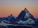
Pic of Adams W ridge from summit of UN 13552.
It is a big day.
I only did Unnamed 13552 in the last 2 years and that is a cool peak. The mists on that day added to the "mystique," but the tiny valley that opens from the northeast of the summit was filled with interesting rock formations. Also, my eye was drawn eastward from the summit, to the connecting ridge with Adams.
If your fitness allows for such a day (no slight intended), then a giant and rewarding day would be to take the Adams South Ridge route, then descend its W ridge (you might not be able to stay proper the whole time-that's where I ran afoul of some complex terrain for a bit - but if so drop north), keep trekking west to ascend 13552, then drop SE into the hanging valley and down to Willow Lake. So you would enter and exit from Willow Lake.
I'm sure you'll end up loving whatever itinerary you come up with.
Pic of Adams W ridge from summit of UN 13552.
- Adams fr UN 546.jpeg (196.92 KiB) Viewed 319 times
I have phenomenal route-finding abilities. Specifically, I have an uncanny knack for selecting the path of most resistance.
-
Chicago Transplant

- Posts: 4066
- Joined: 9/7/2004
- 14ers: 58 12 24
- 13ers: 699 46 35
- Trip Reports (66)
Re: Mt. Adams conditions? Loop optimization?
I did that same loop about 10 years ago, that was a great route! The south ridge of Adams was fun, a little bit of class 3 but if memory serves pretty easy to navigate.coopergould wrote: ↑Thu Jun 12, 2025 11:32 am Currently thinking ascend to Willow Lake, up to UN13,543, up Adams South ridge, down Adams NW ridge to UN13,159, and then back to the car via South Crestone Lake.
6/20/15, so very similar time of year, and we did get a lot of mosquitoes below treeline. There was as creek crossing coming out of South Crestone we took shoes off for and I had about 8 bites per foot just from the creek crossing.
Alternate would be to do 13543/Adams/13552 loop from Willow. I have also done Adams and 13552 together as just the pair from Willow and those ridges were fun too, but if you want to get in two basins, the first option is a good way to go!
"We want the unpopular challenge. We want to test our intellect!" - Snapcase
"You are not what you own" - Fugazi
"Life's a mountain not a beach" - Fortune Cookie I got at lunch the other day
"You are not what you own" - Fugazi
"Life's a mountain not a beach" - Fortune Cookie I got at lunch the other day
-
yaktoleft13

- Posts: 475
- Joined: 4/17/2017
- 14ers: 58 15
- 13ers: 375 33
- Trip Reports (27)
Re: Mt. Adams conditions? Loop optimization?
I did the 552 -> Adams -> 159 loop up willow creek and down S crestone this winter. I've got a trip report up on them if you look and should have some good beta. I think that'd be a great loop and the best way of doing them. You'll be able to shave off a bit of distance with a more direct descent route off 159, and if you go that direction you get to ascend the very well-defined willow creek trail in the dark, which makes the night miles easy. Also, a direct ridge descent down Adams toward 159 will make life easier.
It's an aesthetic loop for sure, both in route and in views!
It's an aesthetic loop for sure, both in route and in views!
-
supranihilest

- Posts: 850
- Joined: 6/29/2015
- 14ers: 58 42
- 13ers: 744 2 8
- Trip Reports (121)
- Contact:
Re: Mt. Adams conditions? Loop optimization?
You can do the three unnamed 13ers plus Adams basically like I did, just from the west instead of the east. Going up South Crestone, hitting Adams' northwest, west, and south ridges, then going down Willow would make a nice tour.
https://www.14ers.com/php14ers/triprepo ... trip=20241
https://www.14ers.com/php14ers/triprepo ... trip=20241

Re: Mt. Adams conditions? Loop optimization?
I hiked 13,159 yesterday from S Colony lake and took photos, which shows snow amounts. I can’t upload photos now with my phone (image too large) but I messaged my number if you want me to text them. I’ll try uploading photos with a conditions report later tonight after I get home.

