Log In 
Difficulty
 Class 2 

 Intermediate or Novice, D3 / R2 / II
Risk Factors
ExposureLow
RockfallLow
Route-FindingLow
CommitmentLow
Trailhead
Summit
13,207 feet
Elevation Gain
1,800 ft
Length Round-TripRT
5 mi
Peak Conditions
Downloads
Photo
Show More
Route Last Updated: Dec 2025

Trailhead

Drive to S. Park Ave. on the south end of Breckenridge. Turn west and drive 0.2 miles and turn left on Village Road. Drive 0.2 miles on Village and turn left into a large parking lot near the Beaver Run complex. A chairlift goes by the lot. Turn left, cross the lot and turn right onto County Road (CR) 751 (dirt). This road leads to the top of the Peak 9 section of the ski area. After 0.5 miles keep left. There is a gated road on the right. Pass a lift and drive around to another intersection near 0.8 miles. Stay right on the main road and begin the climb into the ski area. Near 1.5 miles, stay right. Near 3.0 miles, go under a lift. Stay on the main road and pass the Overlook Restaurant. Continue up to the highest lifts near 3.6 miles. This is the trailhead. The road is rough from here and 4WD is required. If you drive another 1/2 mile, there is a small pull-off on the right.


If the ski area is open, you can take the Mercury Super Chair to the start of this route. Above the lift, locate the road that provides backcountry access. Daily access is determined by the ski area, so call the ski patrol in advance.

Route Description

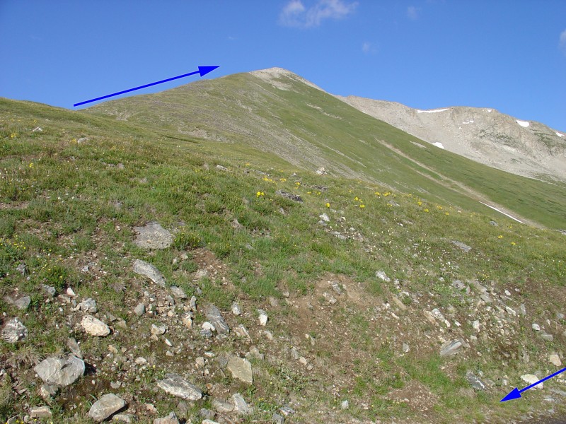
 1 shows the route from the top of the Breckenridge ski area. Leave the ski area and hike up the road. The road goes all the way to 13,400' on Peak 10! This route uses the route to 12,400' and then climbs the east ridge on Peak 9. Leave the forest near 11,800' and continue on the road as it switchbacks up a shoulder to 12,100'. The road then heads west along the north side of the shoulder ( 2) before turning left where it intersects the Wheeler trail.  3 looks up at Peak 9 from near the Wheeler trail junction.

After passing the Wheeler trail, hike up onto the start of the East Ridge. Leave the road and hike west across easy terrain -  4. There's no defined trail on the ridge. Near 12,500', the ridge gets a little steeper but it's still easy hiking.  5 shows the remaining hike from a different angle.  6 was taken more than 1/2 way up the ridge. Keep hiking on grass and rocks (or snow) to reach a rounded false summit near 13,150'. Cross a small saddle and climb up onto the real summit.  7 looks down on the false summit.  8 looks north from the top.

Skiing?

If you plan to ski or board Peak 9, there are a few good options:

1) Intermediate+: Drop east off the true summit ( 9) and immediately turn left. Descend about 400ft of Intermediate+ terrain and turn right to descend into the ski area.  10 shows some of the descent. Out of the three ski routes described here, this one is usually the most prone to avalanche.

2) Intermediate: Go back to the false summit and ski the long intermediate slope that runs parallel to the east ridge.  10 shows the descent.

3) Novice: Drop southeast off the summit and ski Peak 9's Southeast Slope. This slope is seen in  5. It's the easiest descent off of Peak 9. When you reach the basin between Peak 9 and Peak 10, turn left and ski over the lower East Ridge to reach the ski area.

Note: These routes lead into black diamond ski trails in the ski area. If you ski the easier, Southeast Slope, it's possible to ski your ascent route back down the lower East Ridge and back to the top of the Mercury Super Chair. The topo map also shows the ski routes.

Notes

County Road 751 is closed in winter and early spring. It is usually opened in late June or early July. In winter, if you lose the road above tree line, hike up onto the east ridge and follow it all the way up to the summit.

Maps

JPG Image
Static Map JPG
Interactive Map & 3D Flythrough
Human Verification Required

Photos

#1#2#3#4#5#6#7#8#9#10

Weather

Caution: The information contained in this route may not be accurate and should not be the only resource used in preparation for your climb. Failure to have the necessary experience, physical conditioning, supplies or equipment can result in injury or death. 14ers.com and the author(s) of this route provide no warranties, either express or implied, that the information provided is accurate or reliable. By using the information provided, you agree to indemnify and hold harmless 14ers.com and the route author(s) with respect to any claims and demands against them, including any attorney fees and expenses. Please read the 14ers.com Safety and Disclaimer pages for more information.

Copyright: Route information, text, risk factors, maps, GPX files, charts, photos, 14ers.com-created map imagery, flythroughs, and other content provided in this route description are copyrighted by 14ers.com and may not be copied, reproduced, republished, distributed, modified, or used to create derivative works without prior written permission.

Please respect private property: 14ers.com supports the rights of private landowners to determine how and by whom their land will be used. In Colorado, it is your responsibility to determine if land is private and to obtain the appropriate permission before entering the property.

Heading to a 14er soon? Don't forget the 14ers.com mobile app.
Google Play     Apple App Store