Log In 
Photo

Combination Route

 Castle and Conundrum
Difficulty Difficult Class 2 
Risk FactorsExposure: Considerable
Rockfall Potential: Considerable  
Route-Finding: Considerable  
Commitment: Considerable  
 
TrailheadCastle Creek
Start9,800 feet
Summit14,274 feet
Total Gain4,850 feet if you start at the main trailhead
3,350 feet if you start at 11,200'
RT Length14.5 miles if you start at the main trailhead
8 miles if you start at 11,200'
Last UpdatedApr 2025
Show More
Photo

Trailhead

Take Castle Creek from the roundabout just west of the center of Aspen. Drive 12.5 miles (paved) to the Castle Creek trailhead. To the right, Forest Road (FR) 102 continues all all the way to 12,800'. Good-clearance passenger cars can drive about 1 mile up this road to reach the dispersed camp sites along the road. If you want to shorten your hike by parking higher, you must have a 4WD vehicle with good clearance. From the lower trailhead parking area, proceed to a river crossing, at 1.3 miles. In spring and early summer, this crossing is a challenge for some 4WD vehicles. At 3 miles, reach the Pearl Pass junction and stay right on the Castle Creek 102 road. If you drove up this far, there are a few parking spots near the junction. The road gets worse as it ascends into Montezuma Basin all the way to 12,800'.

Route Description

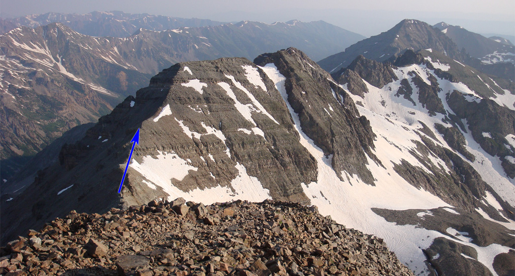
First, follow the Castle Peak Northeast Ridge Route to summit Castle Peak. From the summit, Conundrum Peak is in view to the northwest -  1. Begin the traverse by descending northwest along Castle's northwest ridge -  2 and  3. As you descend, you'll encounter loose rock, so proceed carefully. Continue down as you pass several rock outcroppings along the way -  4. Approximately halfway down, the pitch eases a bit ( 5) as you make your way toward the Castle-Conundrum saddle. Stay on the ridge crest, occasionally shifting to the left side ( 6), until you reach the saddle at 13,790' -  7 and  8.

From the saddle , the route up Conundrum's south ridge is fairly straightforward. Follow trail segments that weave through loose rock and small ledges as you climb toward the summit ridge -  9. After climbing a short distance, pass by a rock outcropping ( 10) to arrive at a flat area -  11. Beyond this point, the terrain steepens slightly, though it remains within "Difficult Class 2" difficulty. Use trail sections and gaps in the rock for easier progress -  12. Continue climbing to reach the southern end of Conundrum's summit ridge -  13 and  14. Conundrum has two "summits," with the true summit located to the north. Walk along the ridge to a notch between the two summits -  15. Descend briefly and cross a flat section before ascending the final pitch ( 16) to reach Conundrum's summit -  17 and  18.

For the descent, return to the Conundrum-Castle saddle -  19. Next, you'll decide how to descend into the upper basin. If the slope between the saddle and the small lake is snow-free, do NOT take this shortcut. Without snow, it becomes a dangerous, unstable descent. The safer option is to reclimb Castle Peak and descend via its standard Northeast Ridge Route. However, if the pitch is snow-covered and you choose to take this direct descent, use your ice axe and navigate carefully down the snowy slope -  20 and  21. Before reaching the small lake, stay left and traverse along the side of the basin to avoid approaching the lake too closely -  22 and  23. Continue heading northeast, exiting the upper basin -  24.
Notes

IMPORTANT: This route enters the Maroon Bells - Snowmass Wilderness area. Designated wilderness areas have special regulations and restrictions for party size, dispersed camping, campfires, etc. Also, dog owners should read the wilderness information carefully because some wilderness areas prohibit dogs to be off-leash and/or limit how close dogs can be to lakes and streams. If you have questions about the wilderness area, please contact a U.S. Forest Service office for the National Forest(s) listed above.
#1

Caution: The information contained in this route may not be accurate and should not be the only resource used in preparation for your climb. Failure to have the necessary experience, physical conditioning, supplies or equipment can result in injury or death. 14ers.com and the author(s) of this route provide no warranties, either express or implied, that the information provided is accurate or reliable. By using the information provided, you agree to indemnify and hold harmless 14ers.com and the route author(s) with respect to any claims and demands against them, including any attorney fees and expenses. Please read the 14ers.com Safety and Disclaimer pages for more information.

Please respect private property: 14ers.com supports the rights of private landowners to determine how and by whom their land will be used. In Colorado, it is your responsibility to determine if land is private and to obtain the appropriate permission before entering the property.
Heading to a 14er soon? Don't forget the 14ers.com mobile app.
Google Play     Apple App Store