Log In 
Photo

Mount Aetna

Grand Couloir
Difficulty Difficult Class 2 
Snow Steepness: Moderate 
TrailheadBoss Lake
Start9,700 feet
Summit13,747 feet
Total Gain4,100 feet
RT Length7.5 miles
AuthorBillMiddlebrook
Last UpdatedMay 2023
DownloadsgpxGPX File
Show More
Photo
?WARNING!
This route should only be climbed with consolidated, stable snow, usually in spring or early summer. In mid-winter, many snow routes have frequent risk of avalanche.

Trailhead

From the intersection of U.S. 285 and U.S.50, just north of Poncha Springs, take U.S. 50 west for approx. 12 miles. Just after the Monarch Lodge, turn right into the parking area for Monarch Snowmobile Tours. Pass their building to find the start of Forest Service Road 230 and a small parking area just beyond the start of 230.

Route Description

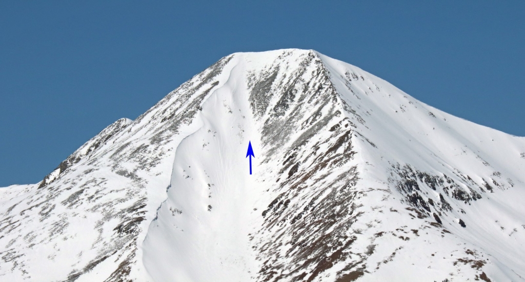
You may have seen it - here's a view of Aetna's Grand Couloir, from Monarch Pass -  1. This classic line should only be done as a snow climb and is skied by many people each Spring. Park in the small, Boss Lake trailhead parking area or across the highway at Monarch lodge and start your day by walking up Forest Service (FS) road 230 -  2 and  3. Pass the turn-off for Boss Lake after 1.5 miles ( 4) and continue another mile to reach a corner, where the view opens up to the southwest -  5. Walk around the corner and turn right to enter the large run-out below the Grand Couloir -  6. If you've previously only viewed the Grand Couloir from Monarch Pass, you might be surprised by how low-angle it looks from this vantage but don't be fooled, this foreshortened view cannot hide the fact that there's 2,900' of gain between you and the summit.

Continue northeast across the openness of the run-out and begin your ascent of the Grand -  7 and  8. Pass through a narrow-ish section between 11,600' and 11,800' to reach easier ground, near a slight turn in the couloir -  9. Once above 12,000', the remaining 1,800' to the summit becomes obvious -  10. Continue climbing north -  11,  12,  13,  14 and  15. Between 13,100' and 13,400', the couloir steepens to approx. 38 degrees and is the crux of the route. Above 13,500', angle northeast ( 16 and  17) to gain the summit ridge and the top of Mt. Aetna -  18 and  19.
Notes

None
#1 #2 #3 #4 #5 #6 #7 #8 #9 #10 #11 #12 #13 #14 #15 #16 #17 #18 #19

This page is only available to registered 14ers.com users. If you don't have an account, you can register in the forum.

Log In_

Caution: The information contained in this route may not be accurate and should not be the only resource used in preparation for your climb. Failure to have the necessary experience, physical conditioning, supplies or equipment can result in injury or death. 14ers.com and the author(s) of this route provide no warranties, either express or implied, that the information provided is accurate or reliable. By using the information provided, you agree to indemnify and hold harmless 14ers.com and the route author(s) with respect to any claims and demands against them, including any attorney fees and expenses. Please read the 14ers.com Safety and Disclaimer pages for more information.

Please respect private property: 14ers.com supports the rights of private landowners to determine how and by whom their land will be used. In Colorado, it is your responsibility to determine if land is private and to obtain the appropriate permission before entering the property.
Heading to a 14er soon? Don't forget the 14ers.com mobile app.
Google Play     Apple App Store