Sayres Benchmark

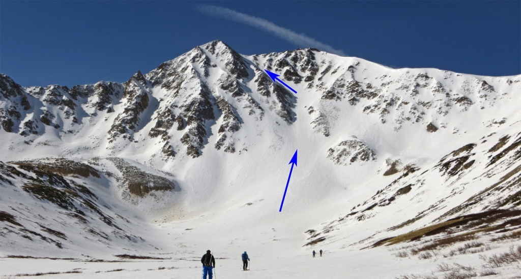
Grand Central Couloir
print
Difficulty Difficult Class 2 
Snow Steepness: Moderate 
TrailheadLa Plata Peak
Start10,000 feet
Summit13,738 feet
Total Gain3,850 feet
RT Length10.50 miles
AuthorBillMiddlebrook
Last Updated11/2017
Show More
Photo
?WARNING!
This route should only be climbed with consolidated snow, in SPRING or early summer. Climbing this route in mid-winter could put you in DEADLY avalanche conditions.

Trailhead

From U.S. 24 south of Leadville, take Colorado 82 west towards Twin Lakes. Drive 14.5 miles on Colorado 82 until you see the marked trailhead and parking area on the left.

Route

From the parking area, walk down South Fork Lake Creek road 100 yards, cross a vehicle bridge ( 1) and continue on the road for 1/4 mile to find a trail sign on the left - 2. Walk east into the woods and continue on the trail for 14er La Plata Peak. Hike through the forest and cross South Fork Lake Creek on a metal+wood bridge - 3. Turn sharply right up from the bridge, walk another 1/3 mile and cross La Plata Gulch on a small log bridge. Turn right and continue south along La Plata Gulch. Between 10,400' and 10,700', the trail has log and stone steps ( 4) that make the steep climb through the forest a bit easier.

Above 11,000', the pitch eases and you'll see clearings in La Plata Gulch off to your right. Leave the La Plata Peak trail, angle right over to the clearings and hike along La Plata Gulch - 5. Staying near the creek, continue south up the Gulch, through a short section of trees and then another mile to reach a flat spot that provides an excellent view of Sayres' north face - 6 and 7. The north face holds two, excellent snow lines: X-Rated Couloir and Grand Central Couloir - 8. X-Rated is a bit complex and more difficult and Grand Central is easy to follow and not as steep. Descend slightly, cross some flats and continue to the base of the north face - 9.

Once above 12,000', angle into the wide run-out at the base of Grand Central - 10 and 11. Begin climbing the steepening terrain and enter the defined couloir, near 12,600' - 12. There are a few sections of the couloir where the steepness approaches 40 degrees. Near 13,000', turn left at a bend where you'll see the upper couloir - 13. Continue climbing 600' to reach the top of the couloir - 14, 15 and 16. Turn left and hike 100' to reach the summit - 17 and 18.

Skiing?

Ski Difficulty Ratings: Advanced, D8 / R3 / II
Top of the couloir: 19 and 20
Near the bend: 21 and 22
Lower half: 23, 24 and 25
Re-entering the trees, near 11,000': 26

Notes

None
#1 #2 #3 #4 #5 #6 #7 #8 #9 #10 #11 #12 #13 #14 #15 #16 #17 #18 #19 #20 #21 #22 #23 #24 #25 #26

The route Google Map can only be accessed by registered 14ers.com users. If you don't have an account, you can register in the forum.

Log In_

Caution: The information contained in this route description may not be accurate and should not be the only resource used in preparation for your climb. Failure to have the necessary experience, physical conditioning, supplies or equipment can result in injury or death. 14ers.com and the author(s) of this route description provide no warranties, either express or implied, that the information provided is accurate or reliable. By using the information provided, you agree to indemnify and hold harmless 14ers.com and the route description author(s) with respect to any claims and demands against them, including any attorney fees and expenses. Please read the 14ers.com Safety and Disclaimer pages for more information.

Please respect private property: 14ers.com supports the rights of private landowners to determine how and by whom their land will be used. In Colorado, it is your responsibility to determine if land is private and to obtain the appropriate permission before entering the property.
Heading to a 14er soon? Don't forget the 14ers.com mobile app.
Google Play   Apple App Store
© 2023 14ers.com®, 14ers Inc.