From the parking area, take the main trail east and then north for 0.2 mile. Before the old road/trail passes between a couple of large boulders, turn right and look for a faint trail which leads down toward the creek -
1. Walk down to a rock-filled trench/old road and follow it northeast for 0.1 mile to reach the main stream -
2. Cross the stream and continue right on an old road which heads east into the trees. Staying on the road, switchback 0.7 mile to 11,400' and locate a trail on the left side of the road -
3. Finding this trail is turn-off is important. Follow the trail for over 0.1 mile to reach the ruins of an old cabin and then another one just to the east -
4. At the second cabin, turn hard-right and locate the trail as it continues southwest up into the forest -
5. Carefully follow the trail (
6) east as it becomes less-defined and overgrown before reaching a distinct gully -
7. Do not cross the gully - turn right and continue west up the trail. Near 11,900', the trail becomes vague (
8) as you pass under some steep ledges in the forest -
9. There's no need to climb up through the ledges so try to stay on-trail and continue southwest beneath the ledges. The trail exits the trees through a gap near 12,000' -
10, which is indicated on topo map #2 as "Tree Line."
Continue south out of the trees and you'll find yourself at the base of a steep, talus slope (
11) below the ridge which must be gained to summit Lackawanna. The slope is loose and a bit dangerous but you can mitigate this by hiking a bit farther south to bypass some of the ledges and talus difficulties before turning left to begin your ascent -
12. Taken from Highway 82,
13 provides a different look where you can see why it's easier to head south for a bit before climbing the slope. Once you pick your line, climb approx. 1,000' (
14 and
15) to reach the ridge crest between 12,900' and 13,000' -
16. Hike south along the ridge, work your way around some rocky sections (
17) and reach the top of Unnamed 13,660' (
18) where you can see the summit of Lackawanna, just over 1 mile away -
19.
Drop southeast from Unnamed 13,660' (
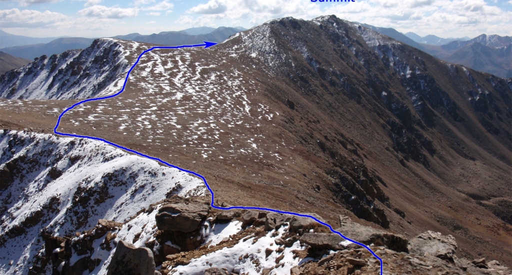
20) and walk along the ridge to reach a large, flat area -
21. Continue south, bypassing the top of Point 13,590', and ascend a false summit (
22 and
23) where you can finally see the true summit, 0.25 mile to the south -
24. Ascend the hump shown in
24 and take a few more steps to gain the summit block -
25.
26 looks back to the northwest.
