Download Agreement, Release, and Acknowledgement of Risk:
You (the person requesting this file download) fully understand mountain climbing ("Activity") involves risks and dangers of serious bodily injury, including permanent disability, paralysis, and death ("Risks") and you fully accept and assume all such risks and all responsibility for losses, costs, and damages you incur as a result of your participation in this Activity.
You acknowledge that information in the file you have chosen to download may not be accurate and may contain errors. You agree to assume all risks when using this information and agree to release and discharge 14ers.com, 14ers Inc. and the author(s) of such information (collectively, the "Released Parties").
You hereby discharge the Released Parties from all damages, actions, claims and liabilities of any nature, specifically including, but not limited to, damages, actions, claims and liabilities arising from or related to the negligence of the Released Parties. You further agree to indemnify, hold harmless and defend 14ers.com, 14ers Inc. and each of the other Released Parties from and against any loss, damage, liability and expense, including costs and attorney fees, incurred by 14ers.com, 14ers Inc. or any of the other Released Parties as a result of you using information provided on the 14ers.com or 14ers Inc. websites.
You have read this agreement, fully understand its terms and intend it to be a complete and unconditional release of all liability to the greatest extent allowed by law and agree that if any portion of this agreement is held to be invalid the balance, notwithstanding, shall continue in full force and effect.
By clicking "OK" you agree to these terms. If you DO NOT agree, click "Cancel"...
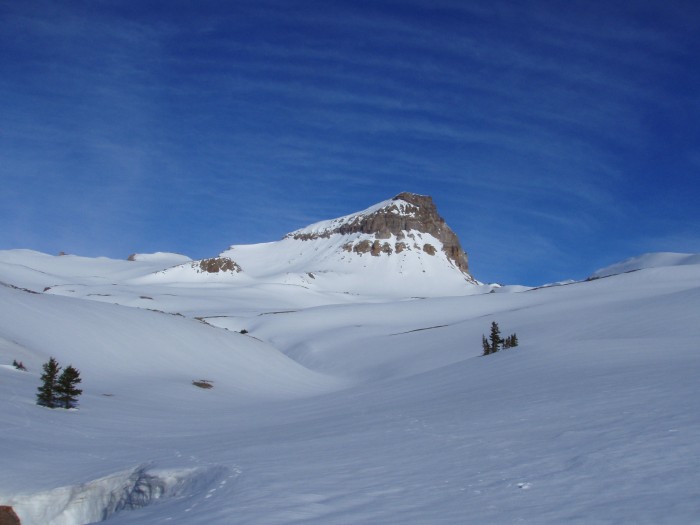
"Unca-pah-gre": Such an ugly name is unfitting for this beautiful place.
I had Uncompahgre in mind during a trip that me and a friend made a week ago to Lake City. Unfortunately, after climbing Redcloud and Sunshine a storm rolled through for the next couple of days and ruined our ambitious plans. The real problem is that the name uncompahgre has been stuck in my head since, and I find it very unpleasant the way it rolls off the tongue. By far the worst 14er name in my opinion. Anyway, I was hoping that by completing the climb it wouldn't be stuck in my head anymore. Not sure if it worked yet.
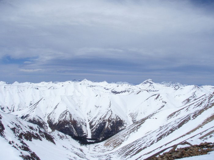
Uncompahgre from Redcloud summit the prior week
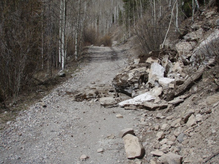
Nellie Creek Road: Rock slides, Streams, and Snow Drifts
Although my vehicle is only 2wd, I have pretty good clearance so I decided to continue on Nellie Creek road to see how far I could get up it. From the turn-off all the way to the first creek there is no snow to worry about but there are a number of rock slides that left good sized boulders on the road. My guess is that no ones been up that road for a while because I had to get out about eight times to move rocks off the road.
Rock slides on Nellie Creek Road
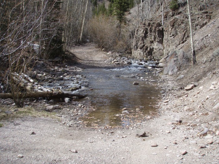
When I finally got to the first stream I found a nice nook to pullover in just before the stream. My vehicle wouldn't have made it, maybe a bigger 4wd would, but it would be unnecessary to cross right now because the road is blocked just a short while after the first stream.
First Creek Crossing/Vehicle Pullover Site
About 100' feet up from the stream you'll see your first couple snow drifts that are passable without snowshoes. An additional 300' up and the road becomes impassable by vehicle because of large snowdrifts. This is where I chose to use snowshoes, and they stayed on for the rest of the trip to the summit.
Road Snowpack begins (10,700')
Camping vs. Single-day trip
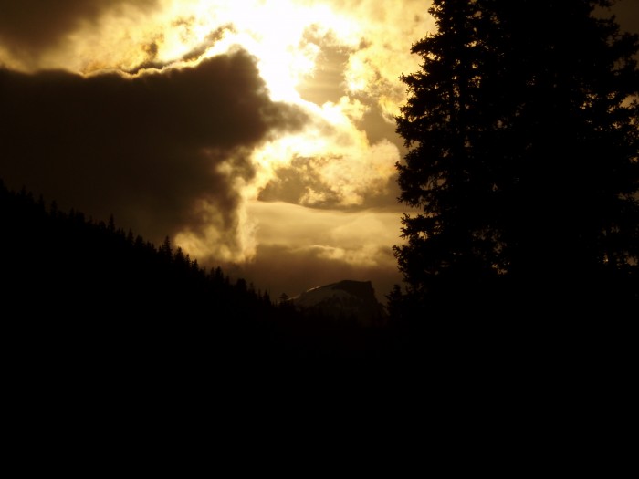
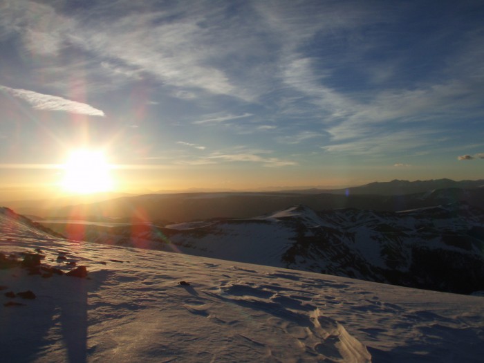
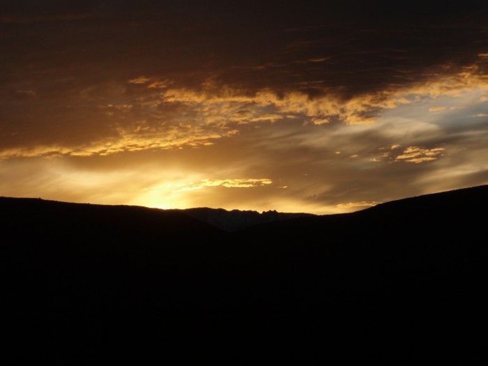
I chose to camp out at tree-line so that I'd have firm snow to travel on the approach in the morning. Travel was pretty quick and camping was definitely unnecessary but it did enable me to see a beautiful sunset and sunrise that I otherwise wouldn't have been able to see.
Sunset on Uncompahgre
As the sun went down I had a tough time finding a dry spot to set up my bivy, but with the help of my trusty head torch I found this nice area hidden from the wind at 11,720'
Dry Patch Bivy-site
You can sleep when you die!
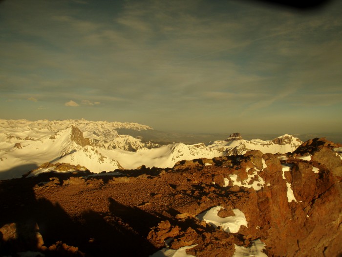
I never sleep very well before a climb because of the excitement and anticipation, so when I checked my watch at 3:15am I decided I'd get up, make breakfast, and get a super early start. I was on the trail by 3:45 and everything about the climb just felt great! It started getting light during the last push before the summit ridge. I always love that first look around when it gets just light enough to see what the scenery is around you. It's kind of eerie at first. Then its just beautiful.
Summit Ridge at Sunrise
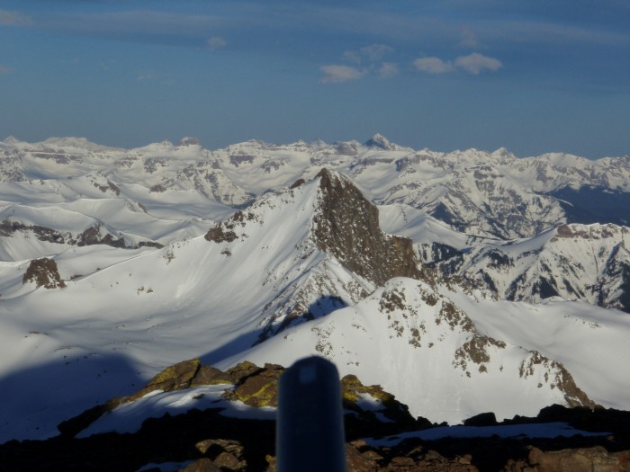
The trail was very straight forward and I had no trouble finding my way to the summit. This summit definitely takes the cake on being most scenic.
Summit Ridge at Sunrise
Summit View
Summit View
Summit View
Wetterhorn
Redcloud and Sunshine
Glissader's Paradise
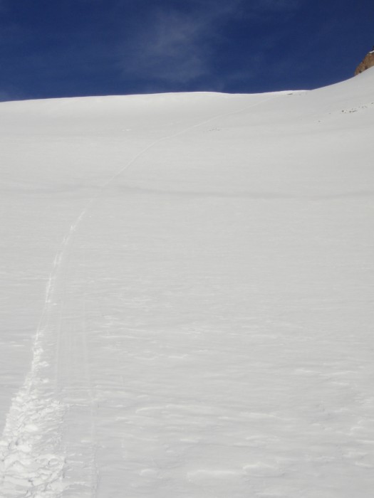
I've glissaded on a number of peaks this winter, but I always seem to hit the peaks too late to get a great glissade out of it. That wasn't the case here. As I descended from the summit I checked my watch and saw that it was still only 6:45. With ice axe in hand I began my glissade from the summit ridge. Awesome! Not only was the snow the perfect firmness to get a good slide on, and not only were there a number of great glissade lines all the way back down to tree-line, but I found that every slide had a safe run-off that ended in a bowl. My first slide dropped me about 650' vertical in seconds. My GPS tracked my speed at a steady 15-17 mph. Fast enough that my ass was burning by the time I got to the bottom.
My initial glissade line
I haven't heard too much talk on the forums about the glissade opportunities on Uncompahgre, but I found it to be perfect, especially if you can hit it super early in the morning like I did. This picture doesn't do it justice.
Looking back on the approach to Uncompahgre and the awesome glissade oppurtunities
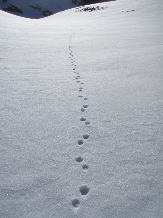
On the way back down to camp I also found some coyote tracks traveling directly towards by bivy site. Luckily, no coyotes got into my food or other stuff.
Coyote tracks
What makes a favorite peak?
I'd have to say this peak is my new favorite so far. Before this one, no climb really stood out as being more enjoyable than the rest. I actually questioned whether I'd have a favorite peak before leaving Colorado in June. It got me thinking about what it actually takes to become a favorite. For me, I have to feel like I had a very controlled ascent and descent of the mountain. I don't get a large thrill when it comes to taking chances with safety. I love pushing my body to the limits, but I can't continue to do that if I'm dead! For this reason I've stayed away from more technical stuff while I've been in Colorado and stuck with the stuff that challenges my cardio. I found Uncompahgre to be a nice balance. The approach was rather quick, but I still was able to push hard on the ascent and have fun on the descent. It also has an amazing view from the summit.
My favorite summit to date? I think so!
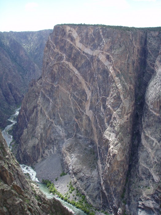
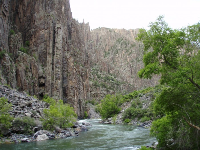
I got back into Lake City, still very early in the day, and decided to head to the Black Canyons near Montrose to hike down into the inner canyon and camp out. Although it might not be kosher of me to include that trip into this TR, I'm going to include some photos anyway. If you haven't checked out the Black Canyons yet, it's worth the trip just for the overlooks. If you have some extra time, hike down to the inner canyon from the south rim. It's a good 1800' below the rim, but a whole different experience at the bottom. Camping out down there was quite the contrast with my previous nights camp at 11,700'.
Black Canyons
Painted Wall of the Black Canyons, Colorado's tallest cliff
Inner canyon exploration
My inner canyon Bivy-site
Sunrise during my ascent back to the canyon rim
Sunrise during my ascent back to the canyon rim
Hope you enjoyed the report. Have fun and be safe!
My GPS Tracks on Google Maps (made from a .GPX file upload):
I keep driving by the Black Canyon and saying I need to visit it sometime. After reading your report, I'm going to make it sooner than later. Looks like a great trip !
great report. i am a flatlander now and this is the next one i want to do when i get back out there.
Caution: The information contained in this report may not be accurate and should not be the only resource used in preparation for your climb. Failure to have the necessary experience, physical conditioning, supplies or equipment can result in injury or death. 14ers.com and the author(s) of this report provide no warranties, either express or implied, that the information provided is accurate or reliable. By using the information provided, you agree to indemnify and hold harmless 14ers.com and the report author(s) with respect to any claims and demands against them, including any attorney fees and expenses. Please read the 14ers.com Safety and Disclaimer pages for more information.
Please respect private property: 14ers.com supports the rights of private landowners to determine how and by whom their land will be used. In Colorado, it is your responsibility to determine if land is private and to obtain the appropriate permission before entering the property.