Download Agreement, Release, and Acknowledgement of Risk:
You (the person requesting this file download) fully understand mountain climbing ("Activity") involves risks and dangers of serious bodily injury, including permanent disability, paralysis, and death ("Risks") and you fully accept and assume all such risks and all responsibility for losses, costs, and damages you incur as a result of your participation in this Activity.
You acknowledge that information in the file you have chosen to download may not be accurate and may contain errors. You agree to assume all risks when using this information and agree to release and discharge 14ers.com, 14ers Inc. and the author(s) of such information (collectively, the "Released Parties").
You hereby discharge the Released Parties from all damages, actions, claims and liabilities of any nature, specifically including, but not limited to, damages, actions, claims and liabilities arising from or related to the negligence of the Released Parties. You further agree to indemnify, hold harmless and defend 14ers.com, 14ers Inc. and each of the other Released Parties from and against any loss, damage, liability and expense, including costs and attorney fees, incurred by 14ers.com, 14ers Inc. or any of the other Released Parties as a result of you using information provided on the 14ers.com or 14ers Inc. websites.
You have read this agreement, fully understand its terms and intend it to be a complete and unconditional release of all liability to the greatest extent allowed by law and agree that if any portion of this agreement is held to be invalid the balance, notwithstanding, shall continue in full force and effect.
By clicking "OK" you agree to these terms. If you DO NOT agree, click "Cancel"...
It took me all of two weeks preceding cinco de mayo to finally decide how I wanted to spend my 2 consecutive days off of work, since they haven't come around very often lately. After many flip-flops on 14ers, I finally decided that Blanca looked to be about the perfect place for those two days. The weather turned out to be just as great as the forecast suggested, and the early morning snow was perfect for the climb I was looking for. Let just say I wasn't disappointed in the least bit.
I left Colorado Springs around 8am on Wednesday morning on a beautiful day in Colorado. The Spanish Peaks caught my attention as I headed south and I got even more excited for my first trip to the Sangre de Cristo range. Spanish Peaks
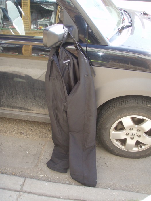
South of Pueblo my heart sank when I realized that I forgot to pack my snow pants, or any kind of hiking pants for that matter, so I opted to stop in Walsenburg and pick up a pair instead of driving all the way back to the Springs. As I drove through town I quickly realized there was little hope in finding any snow pants. The only store that looked slightly promising was April's Attic on mainstreet, and even that looked like an antique store when I walked in. The owner, April, was a nice young woman that assured me that her store was the only store in town that carried any men's clothing. The only thing that even resembled what I was looking for was a pair Women's Size 16 Sportina(?) snowpants. April said "they are $9", I said "sold". Turns out, you get what you pay for! More on that later. Anyway, they fit me fine, just a little wide in the hips. Womens Size 16, made for birthing hips!
Once I got to the little town of Blanca, I stopped at a store called Hit-R-Mis run by a Native American man named Bill. Hit-R-Mis
When he found out my plans to climb Blanca, we both stood outside of his store looking up at the majestic peaks in awe. He told me a story about how Mt. Blanca became one of the four sacred peaks to the Navajo Indians. After hearing this about Mt. Blanca, I felt like my trip became much more important. I asked Bill if the Natives take any disrespect from climbers summitting Blanca peak and he assured me that they don't. This made me feel much more at ease during me ascent.
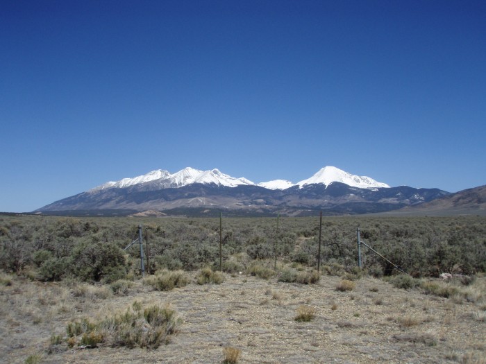
Since this was my first trip to the area, I had to stop at the Great Sand Dunes and summit High Dune and Star Dune. I got a great view of the Crestones and Blanca Massif from Star Dune. Crestones
Blanca Massif
On my way back to Como Lake Road I even got to see some wildlife. This was turning out to be quite a good trip. Mule Deer
When I got to the TH, I actually met a guy coming down that had just summitted Blanca. He ensured me that snowshoes would be a good option, as he had none, and that there were large cornices on the Blanca ridge. This worried me, especially because he told me that Class 3-4 moves were required to get around them. I'll just have to find out when I get up there.
I've heard negative things about this TH, and after experiencing it I can only confirm how crappy it is. Maybe I'm a little bit too nervous when it comes to driving my vehicle over large rocks, but holy shit! I decided to park short of 8,000' in fear that I wasn't going to make it out with my Element unscathed. This made for a long hike up to Lake Como (5.4 miles), half of which I spent hiking in the dark. Next time I'm at this TH, I'll bring a mtn bike. Near the turnoff. It can't be that bad, right?
There's a positive and negative involved with hiking into camp at dark in an area that you're not familiar with.
Negative: If shelters aren't near the trail, you end up setting up camp (a bivy sack in my case) and having a very cold night. You may even find out, like I did, that you set up your bivy about 50 meters away from a shelter. That was stupid! Marmot Alpinist Bivy aka da shit
Positive: Since you can't see where you're setting up, the next morning you get to be surprised with the beauty that surrounds you. Camp
Having never done Little Bear, and therefore never spent any time researching the route, I'm not really sure if this is the correct gully that puts you on the south side of the mtn near the hourglass or not. Anyway, if that's the correct gully, this is what it looked like 5/5. Little Bear Gully leading to the Ridge?
And a look back near Crater Lake. The view of Alamosa at night was pretty cool
Actually, it's more of a look forward since I chose to take all my pictures after I summitted, but I'm presenting it as if they were taken before.
I left camp a little after 4:30 and started making my way up. As you can see from my topo, some of my ascent wasn't very practical because it was still dark until Crater Lake. I was glad that I brought snowshoes for this portion of the trip. Snow wasn't too deep, but it looked like the guy that went up before me w/o them post-holed from 4-6'', and in some spots a foot. When I talked to him the previous day near the TH, he warned me that his route wasn't very good either, so I ended up creating my own route almost exclusively after 12,000'. Btw, I'd hold out on switching to crampons until the lip around 13,200'.
And then those $9 snow pants came back to haunt me! I was practicing my french technique when my upper foot slipped on some loose snow. The foot came down and grazed the opposite pant leg, and that's all it took. When that spike caught the fabric of my $9 snow pants, it was all over but the crying. Before
Fortunately, I always duct-tape. As good as new! After
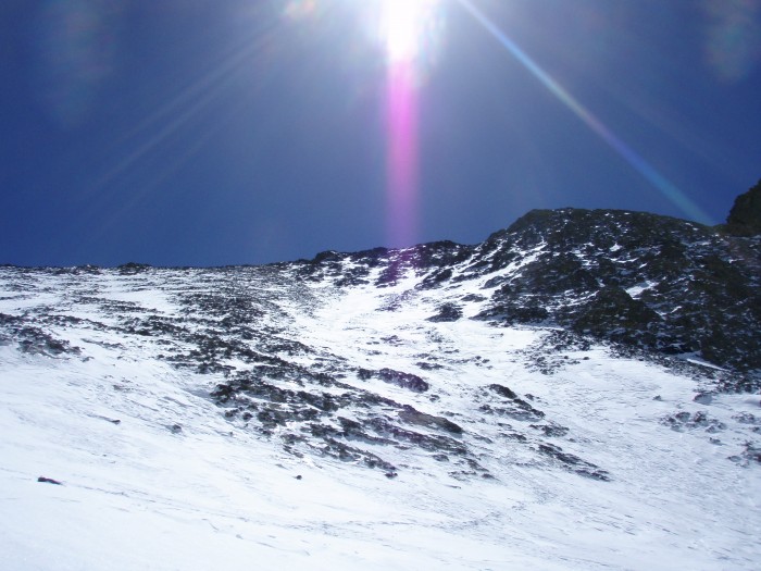
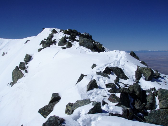
As I worked my way up, I also shot for more of a direct line to ridge north of Blanca. Since the hiker, the day before, warned me of cornices on the ridge about 300' from the summit, my plan was to bypass that section by approaching the ridge about 150' from the summit. I ended up hitting ridge about 200' short of summit but I wasn't in the clear yet. Still plenty of cornices to bypass. If one of those bad boys let loose, it'd be certain death on the east side of the ridge. Watch out!
Bypassing wasn't as bad as the previous days' hiker had me believing it would be. It definitely wasn't any class 4 moves, but there were some sketch spots that had me worried. At one point, I was forced to cross right of a portion of ridge with a cornice. My solution was to keep one ass cheek on the ridge and the opposite foot on the windward, safe-side.
The ridge actually turned out to be a lot of fun! I would have liked a longer stretch of ridge just like that, but the summit came up too fast.
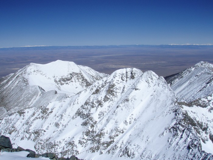
Little Bear
Ellingwood
The way down was pretty uneventful besides how wet and slippery the top layer of snow was getting. It was so warm that I thought I'd be seeing some wet slides, but none. When I got back to Crater Lake around 11:00, some guys were headed up to hit Ellingwood and Blanca. I warned them of the warm snow pack and wished them safe travels. They also had Little Bear in mind for the next morning. I'm curious to hear how that turned out for them.
My GPS Tracks on Google Maps (made from a .GPX file upload):
Sounds like a great adventure, and your write-up was a pleasure to read. You really did a number on those $9 snow pants! But a hell of a repair job, too.
Thanks for posting, and congrats on what must have been a tough solo climb!
Beautiful photos! I was thinking about going to this group in June and do the LB-Blanca traverse but looks like a lot of snow still. I may have to wait until later in the season.
I imagine riding up that road on a mtn bike wouldn't be any more difficult than riding up the beginning switchbacks in route to Pikes Peak. It's going to be less grade than Barr Trail but more obstacles with those large boulders. So I think it could be done from the turn-off all the way to Como Lake; although, it would be quite the work-out.
It dropped about 5 degrees below freezing at night (elev. 11,800). With the sleeping bag and the bivy, I only woke up about once an hour in a violent shiver. That shelter really wouldn't have helped that much because there wasn't very much wind.
I appreciate the kind words! It's an amazing spot on earth.
Good job, duct tape and all. Looks like you picked a perfect day.
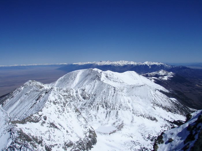
I'm seeing a lot of snow in some of your pictures, like at the summit. Would you say there is continuous snow from the summit down to the basin (i.e., is it skiable)?
I did not see a continuous line from summit down to the basin, and I was looking for one too. Even if you got extra creative, you'd have to take off skis or snowboard for at least 25% of the descent. My photos actually make it look like there was more snow than there actually was.
they were only 9 bucks! It's possible you could have had to do some duct tape repair on $200 pants!
Sweet bivy and great report. Congratulations on this one!
Caution: The information contained in this report may not be accurate and should not be the only resource used in preparation for your climb. Failure to have the necessary experience, physical conditioning, supplies or equipment can result in injury or death. 14ers.com and the author(s) of this report provide no warranties, either express or implied, that the information provided is accurate or reliable. By using the information provided, you agree to indemnify and hold harmless 14ers.com and the report author(s) with respect to any claims and demands against them, including any attorney fees and expenses. Please read the 14ers.com Safety and Disclaimer pages for more information.
Please respect private property: 14ers.com supports the rights of private landowners to determine how and by whom their land will be used. In Colorado, it is your responsibility to determine if land is private and to obtain the appropriate permission before entering the property.


 Spanish Peaks")
 Womens Size 16, made for birthing hips!")
 Hit-R-Mis")
")
 Crestones")
 Blanca Massif")
 Mule Deer")
 Near the turnoff. It can't be that bad, right?")
 Marmot Alpinist Bivy aka da shit")
 Camp")
 Little Bear Gully leading to the Ridge?")
 The view of Alamosa at night was pretty cool")
")
 Before")
 After")
 Watch out!")
")
")
 Little Bear")
 Ellingwood")
")
")