Download Agreement, Release, and Acknowledgement of Risk:
You (the person requesting this file download) fully understand mountain climbing ("Activity") involves risks and dangers of serious bodily injury, including permanent disability, paralysis, and death ("Risks") and you fully accept and assume all such risks and all responsibility for losses, costs, and damages you incur as a result of your participation in this Activity.
You acknowledge that information in the file you have chosen to download may not be accurate and may contain errors. You agree to assume all risks when using this information and agree to release and discharge 14ers.com, 14ers Inc. and the author(s) of such information (collectively, the "Released Parties").
You hereby discharge the Released Parties from all damages, actions, claims and liabilities of any nature, specifically including, but not limited to, damages, actions, claims and liabilities arising from or related to the negligence of the Released Parties. You further agree to indemnify, hold harmless and defend 14ers.com, 14ers Inc. and each of the other Released Parties from and against any loss, damage, liability and expense, including costs and attorney fees, incurred by 14ers.com, 14ers Inc. or any of the other Released Parties as a result of you using information provided on the 14ers.com or 14ers Inc. websites.
You have read this agreement, fully understand its terms and intend it to be a complete and unconditional release of all liability to the greatest extent allowed by law and agree that if any portion of this agreement is held to be invalid the balance, notwithstanding, shall continue in full force and effect.
By clicking "OK" you agree to these terms. If you DO NOT agree, click "Cancel"...
North face Couloir route on "Crestolita." Photo by Jason Halladay.
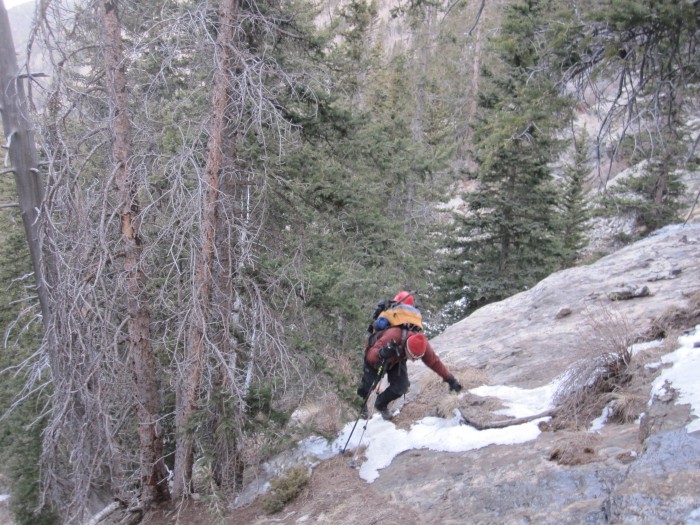
Since it was clear the forest rangers were not patrolling the North Crestone campground, due to the early season, we stayed another night. We woke up 3:30 AM, packed up camp and made the short 15 minute drive to Cottonwood Creek trailhead. I was missing my cup of coffee as we started hiking up at 4:30 AM. The trail travel was a non-event as we made our way up the trail. Around ~10,100, deeper snow appeared and fortunately, the snow was consolidated and frozen making travel fairly easy. Since we didn't use snowshoes at all on 13,054, we figured we didn't need them for this hike and left them at the car.
The trail was hard to follow with the snow and we lost it several times. Eventually, we made our way up past the "boiler" slabs and into the basin just south of the Crestones where the view with the morning sun was quite sobering. We climbed up to the south bench looking over the still frozen Cottonwood Lake. Passage directly in the North Couloir on "Crestolita" from this bench was questionable with grassy snow covered class 4 ledges. We headed back down into the basin where we got a direct view of the north couloir. It was impressive.
Al climbing up the "boiler" slabs.
Sunrise.
Climbing towards Cottonwood Lake. Photo by Al.
First view of the Crestone Needle.
Working our way up towards Cottonwood Lake. Photo by Al.
Crestone Needle.
Al working his way up to the bench south of Cottonwood Lake.
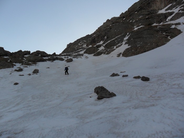
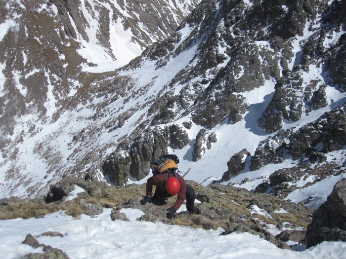
Al wasn't completely sold on the idea of climbing the north couloir on "Crestolita" so we climbed directly up the snow covered west slopes of Broken Hand first to get a better view of things. The snow up Broken Hand was very packed and frozen and crampons were mandatory. We climbed up the snow slopes until ~13,100 were we were able to ditch our crampons and make the class 2 hike to the summit where we arrived at 11:15 AM. The views of the Crestones were very impressive. Having climbed the Needle several times, I had never made it over to Broken Hand and the views were quite rewarding.
Hiking towards Broken Hand. Photo by Al.
Looking up the snow route on Broken Hand.
Climbing up Broken Hand. Photo by Al.
Crestone Needle on the ascent from Broken Hand.
"Crestolita" from the climb up Broken Hand.
Al climbing up Broken Hand.
Al climbing up Broken Hand.
Al climbing up Broken Hand.
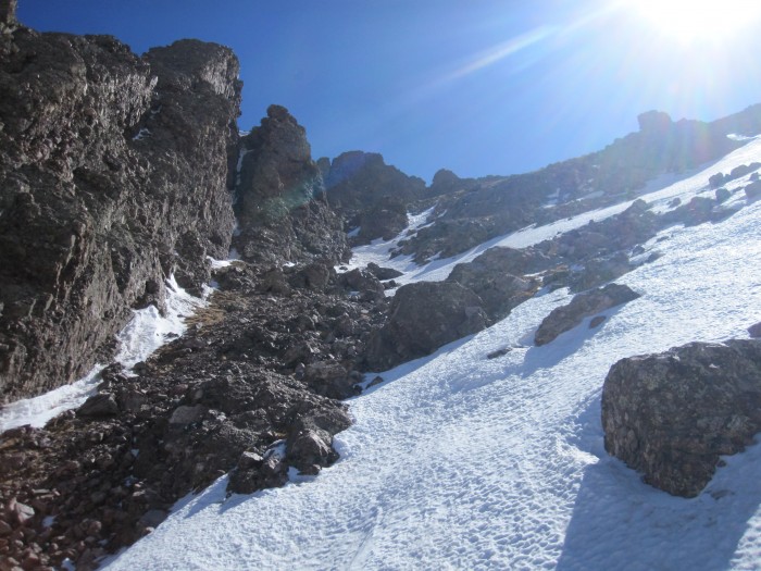
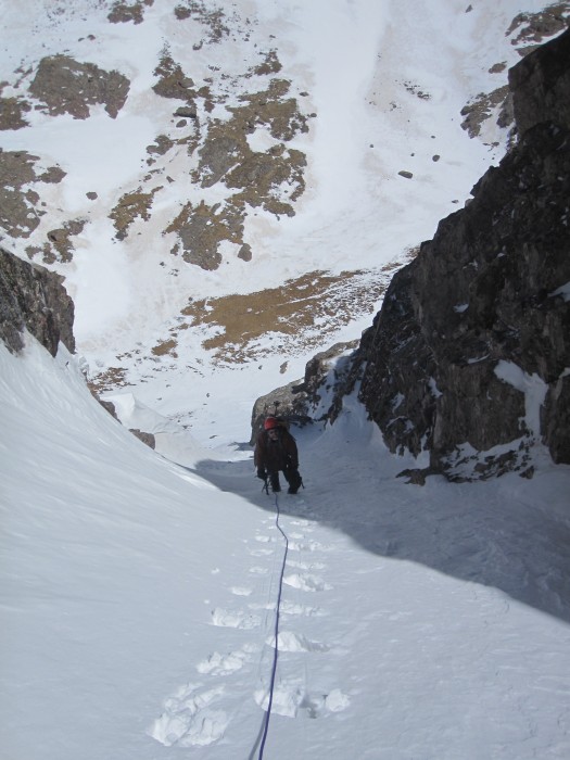
From the summit of Broken Hand, we could see that climbing the standard route up "Crestolita" was out of the question due to an enormous snow cornice looming over the route. That only left the north couloir! We quickly descended Broken Hand back into the basin and at ~12,400 we went ahead and roped up since we both had no idea what the couloir was going to offer. A direct snow climbing line to the summit couldn't be observed.
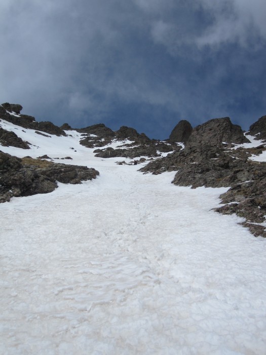
The north couloir on "Crestolita." Photo by Al.
Onward and upward. At first, the snow we packed but not frozen and within 100 feet of starting up the couloir was a short 5 foot steep section that was ~60-70 degrees. Al was glad we roped up since his snow climbing experience has been somewhat limited. The angle eased and most of the couloir varied between 45-55 degrees. About 1/3 of the way up the couloir was a short rocky section which required some creative maneuvering to bypass. The Crestone Needle watched our progress as we ascended upwards.
Al finishing the very steep 5 foot step.
Looking up the couloir. The rocky section can be seen.
Al working his way up the couloir.
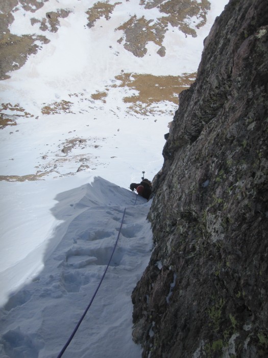
As we climbed higher, we could see that the couloir wasn't going to top the ridge directly. There was a 30-40 foot chimney with a massive boulder blocking further progress. Fortunately, there were a few forks in the couloir and we took the higher left fork which angled across the north face. Our snow climbing ended ~200 feet below the summit. From the top of the snow couloir, we climbed up a short snow covered class 3 section angling east and up to the top of a small buttress which overlooked another very steep couloir.
Al near the top of the couloir.
Snowy class 3 ledges above the couloir. Photo by Al.
We traversed east-southeast across the top of the steep couloir on some extremely exposed snow covered class 3 terrain. Once past this class 3 traverse we were now only 100 feet below the summit and things were looking promising.
Al making the exposed traverse.
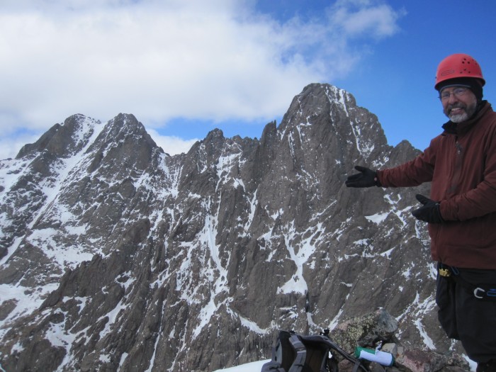
After the traverse, we looked for an easy route directly to the summit. In the summer it would be a non-trivial dry class 4 scramble but the snow made things exciting. The route we found was mostly was class 3 with a few sections with some class 4 moves. We took our time up the slick snow covered rock where we arrived on the summit of "Crestolita" at 2:00 PM. Outstanding views of the Crestones and a great couloir climb. I haven't climbed one that good in a while.
Looking down on Al from the class 4 slabs.
Al working his way to the summit.
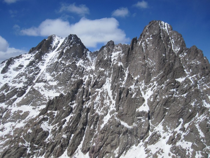
Crestone Peak and Needle from the summit.
Al making the final moves up "Crestolita" with Broken Hand in the background.
Presenting the Crestones.
Eating and resting were good on the summit. We continued almost directly off of the south face of "Crestolita" heading back towards Cottonwood Creek. Descending the south face went quickly and was enjoyable on the snow. About 2/3 of the way down there was a short rocky cliff that we had to bypass. I took the left side and Al took the right (both class 3). Around ~11,600, our post-holing bushwhacking adventure began.
South face descent.
South face descent.
The snow was still consolidated but about every 4th step was thigh deep or deeper. We stayed on the northern edge of the valley trying to stay in sun baked areas where there wasn't snow. Progress was slow and as we descended lower, the steps went from thigh deep to knee deep to shin deep. Finally, we reached the snow free trail and made better progress towards the car arriving at 6:20 PM. A long, outstanding, day.
Thumbnails for uploaded photos (click to open slideshow):
Cool report! Did you guys get a good look at the east and west gullies on the Needle (probably not with the west gully given your location)? Did the snow look pretty thin?
We didn't get a chance to see the snow on the eastern side of the Needle since we approached the peak(s) from the west. Picture 11 shows the main gully taken to the summit of the Needle. From our vantage point on Broken Hand, it appears that it would be a descent snow climb to the summit. I would definitely take crampons.
Al - Now we can do the Rabbit Hole Couloir on Alice??? You wouldn't have any problem at all. You did great!
Hey Guys, nice job on a trail less traveled. Not many climb Crestolita. What a great perspective from that summit of the Crestones. I don't think I've ever seen a picture from there like have in pic #25.
That is a very unique vantage point, very awesome!
Caution: The information contained in this report may not be accurate and should not be the only resource used in preparation for your climb. Failure to have the necessary experience, physical conditioning, supplies or equipment can result in injury or death. 14ers.com and the author(s) of this report provide no warranties, either express or implied, that the information provided is accurate or reliable. By using the information provided, you agree to indemnify and hold harmless 14ers.com and the report author(s) with respect to any claims and demands against them, including any attorney fees and expenses. Please read the 14ers.com Safety and Disclaimer pages for more information.
Please respect private property: 14ers.com supports the rights of private landowners to determine how and by whom their land will be used. In Colorado, it is your responsibility to determine if land is private and to obtain the appropriate permission before entering the property.


")
")
")
")
")
")
")
")
")
")
")
")
")
")
")
")
")
")
")
")
")
")
")
")
")
")
")
")
")
")


