Download Agreement, Release, and Acknowledgement of Risk:
You (the person requesting this file download) fully understand mountain climbing ("Activity") involves risks and dangers of serious bodily injury, including permanent disability, paralysis, and death ("Risks") and you fully accept and assume all such risks and all responsibility for losses, costs, and damages you incur as a result of your participation in this Activity.
You acknowledge that information in the file you have chosen to download may not be accurate and may contain errors. You agree to assume all risks when using this information and agree to release and discharge 14ers.com, 14ers Inc. and the author(s) of such information (collectively, the "Released Parties").
You hereby discharge the Released Parties from all damages, actions, claims and liabilities of any nature, specifically including, but not limited to, damages, actions, claims and liabilities arising from or related to the negligence of the Released Parties. You further agree to indemnify, hold harmless and defend 14ers.com, 14ers Inc. and each of the other Released Parties from and against any loss, damage, liability and expense, including costs and attorney fees, incurred by 14ers.com, 14ers Inc. or any of the other Released Parties as a result of you using information provided on the 14ers.com or 14ers Inc. websites.
You have read this agreement, fully understand its terms and intend it to be a complete and unconditional release of all liability to the greatest extent allowed by law and agree that if any portion of this agreement is held to be invalid the balance, notwithstanding, shall continue in full force and effect.
By clicking "OK" you agree to these terms. If you DO NOT agree, click "Cancel"...
Due to the really poor weather, I had bailed the previous week on a chance to hike Yale. Instead Monday and Tuesday were perfect days: above freezing even above 13k feet and quite clear. The only downside was the obligatory wind - which among other things crippled my photography. Fluted Peak made for a significantly longer day, but with basically no driving required it worked out well.
This turned out to be an extremely fun route. It was barely even class 2, but that was perfect for me at this time of year.
The majority of the background for this climb came from the top of Mount Adams, when I noticed a cool-looking approach from North Crestone Lake straight up into the plateau northwest of Fluted. Missing from the view was the portion right above the lake, and the route from the plateau up to the summit itself. A bit of internet research indicated these portions were climbable but said nothing about difficulty.
The plateau is in the middle - North Crestone Lk in the lower left and Fluted Pk in the upper right
The second thing to consider is distance. Fluted is at 13554', versus the trailhead at 8600' makes for a minimum of about 5000' gain; the trail is very rolling and I'd estimate 150-350 feet of reverse incline. It's also really long: 7-9 miles one way from trailhead to lake, depending on who you ask. As a December hike, it seemed likely that there would be a fair bit of snow below and around the lake but probably none above it.
I put this climb on the back burner, waiting for the perfect day.
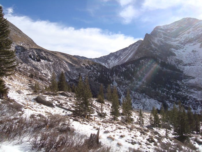
Hiking to the lake
The forecast for Monday was perfect - but I wasn't ready in time to get on the trail early enough. Tuesday forecast was almost as good - still above freezing at 13000 feet (!), with a few clouds but the wind was supposed to be less. Unfortunately I still didn't manage to get on the trail until 7:30. Up to the first creek crossing and "three forks", the trail was clear of snow, but after turning south snow gradually got deeper on the way up. Below the basin's "zig-zag" I don't think this basin gets a minute of sunshine this time of year, but still it wasn't until past the "zig-zag" that it turned into postholing. I made the mistake of following some footprints and accidentally followed them off the trail then lost them; I ended up cutting around above the snow but being off-trail it was extremely slow and cost me 30-60 minutes. I ended up arriving above the lake right at noon.
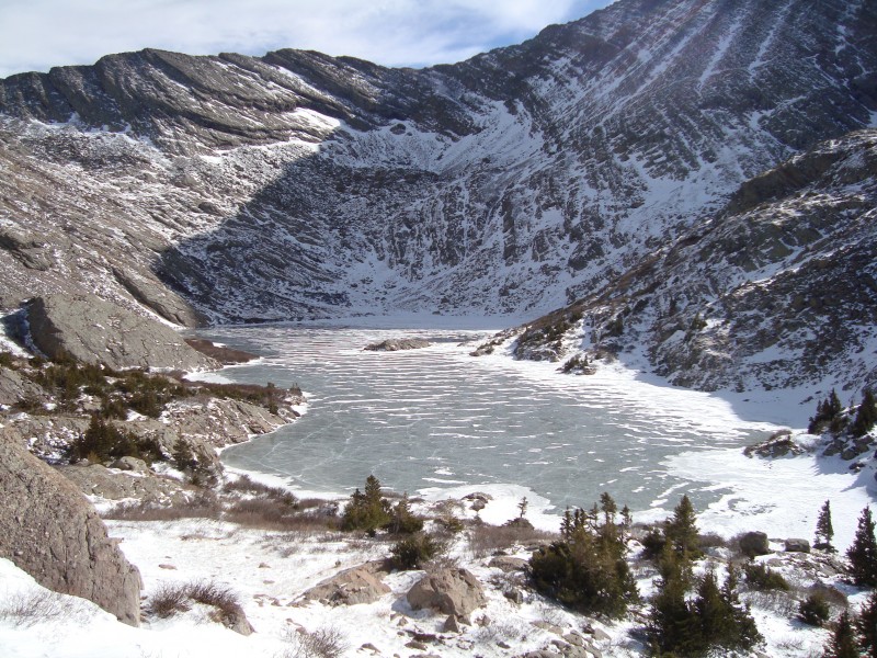
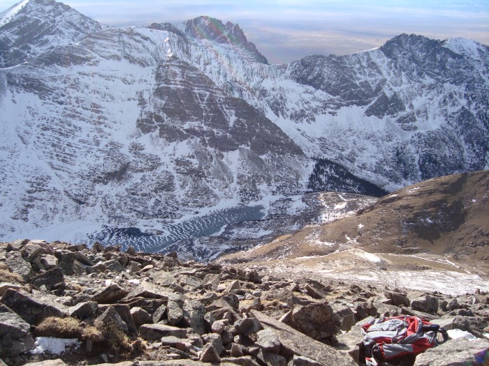
North Crestone Lake The very imposing headwall - Mount Adams NE ridge in the background North Crestone Lake with Mount Adams in the background; the true summit of Adams is barely visible on the right
Fluted Peak
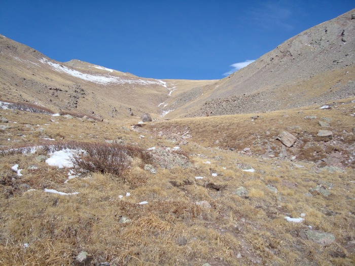
Traversing around the lake at 11900' to get to the gully (which appears to hold a seasonal creek, frozen solid at this time) that heads north around Fluted Peak took longer than it should have. At this point it was 12:15 and I knew if I continued up I'd most likely not get back to the TH until after dark. After a minute of consideration I decided that was ok. I'd say this was the hardest part of the hike; since I was approaching the gully from the west and not head-on there was no good opportunity for route-finding. I just climbed by the easiest-looking route, which was still an easy class 2 but was a bit tedious to avoid clumps of bushes and snow. Around 12300' I arrived in the upper basin, where things became easier and extremely pretty.
The "upper basin" below Fluted Peak (summit is off to the right) Looking back down on the lake
I didn't follow the gully all the way to the ridgeline, instead striking out east and up after getting around the rockiest-looking portions of Fluted's west slope. This turned out to be the perfect spot, and it brought me up to the ridge and the wind in short order. As the pictures show there was no issue with snow in the south-facing gully, and no issue with it along the ridge either. There was, however, an amazing amount of wind. Fortunately it was constant and not gusty. As I approached the summit block I realized first of all that any exposure at all would be too dangerous, and secondly that with my hands freezing and inside overly-stiff gloves, I wouldn't be able to safely climb any class 3 rocks. I almost stopped at the "false summit" to the north of the main peak, as it looked as though there would be scrambling involved, but when I actually made it to at the summit block the piles of rock were easy to walk over. At 2:00 I arrived at the summit and to spectacular views and spectacular wind. I couldn't find a summit register. I took a few photos, including a panorama - large version (54 megapixels) available here.
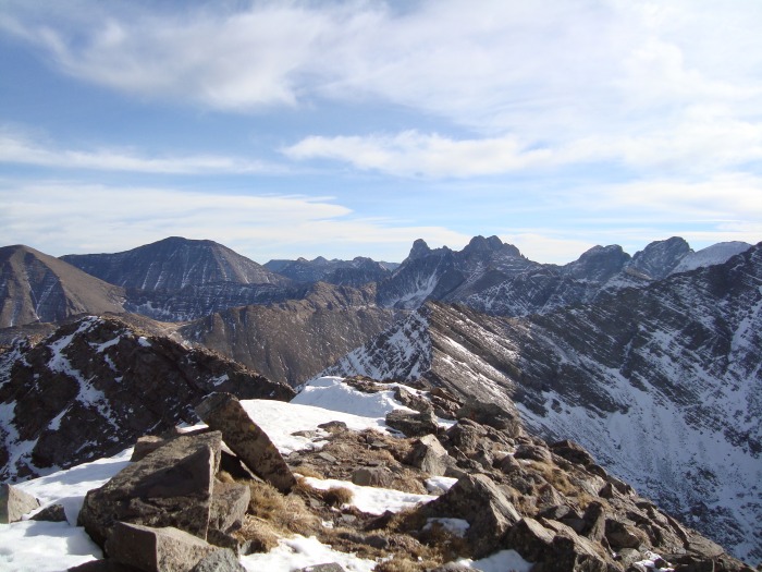
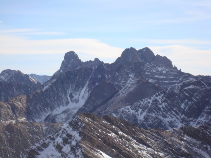
Left to right: Colony Baldy, Humboldt, Crestone Needle, Peak, Columbia, Kit Carson, Challenger, Adams NE ridge Close-up of Crestones Looking down on the lake Low-res panorama
Descent
As it was now 2:20, I knew I had to hurry to get as far as possible before sunset. Heading down the tundra was quite fast, and despite stopping to examine a complete skeleton (it looked like a sheep, but possibly a small elk) and to admire a bizarre uncontained ice flow (I didn't want to take the camera out again to snap photos of either - regrettable in hindsight) I was back above the lake before 3:00. Traversing above the lake was again tedious but I soon made it to the main trail and started flying down it. This time I didn't have any trouble following it, and the snow that was so tedious on the way up was mostly shallow enough that it didn't provide an impediment heading downhill. I did have to break out the headlamp for a few minutes in the dark but made it back to the trailhead and my car at 5:45.
I really enjoyed this route. Tundra hiking is fun to begin with and the tundra below Fluted is very self-contained...everywhere you look it's nothing but tundra and mountains. Most of the hike is completely surrounded by the Sangres with no outside views of any civilization, and the sense of isolation (though not really true) is amazing. Aside from footsteps, the only sign of humanity I saw all day was a small piece of broken glass at around 12400'. The distance wasn't that bad really, aside from having to bushwhack on the way up. Approximate topographic route
Thumbnails for uploaded photos (click to open slideshow):
And, wonderful to see a description from North Crestone Lake (and said trail) which very few people frequent. We, too, did Fluted from that trailhead many years ago ... the views from there are fantastic. Thanks for posting. Happy trails! :D
Did you realize that in your very first picture the shadow of the cloud looks like a finger pointing to one of the peaks. Just thought that was pretty cool
Looks like it was a great hike - definitely better than some of the ”usual” stuff one sees in December. Nice report and pics!
Caution: The information contained in this report may not be accurate and should not be the only resource used in preparation for your climb. Failure to have the necessary experience, physical conditioning, supplies or equipment can result in injury or death. 14ers.com and the author(s) of this report provide no warranties, either express or implied, that the information provided is accurate or reliable. By using the information provided, you agree to indemnify and hold harmless 14ers.com and the report author(s) with respect to any claims and demands against them, including any attorney fees and expenses. Please read the 14ers.com Safety and Disclaimer pages for more information.
Please respect private property: 14ers.com supports the rights of private landowners to determine how and by whom their land will be used. In Colorado, it is your responsibility to determine if land is private and to obtain the appropriate permission before entering the property.
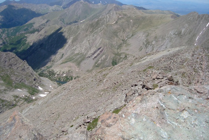


 The plateau is in the middle - North Crestone Lk in the lower left and Fluted Pk in the upper right")
 The very imposing headwall - Mount Adams NE ridge in the background")
 North Crestone Lake with Mount Adams in the background; the true summit of Adams is barely visible on the right")
 The")
 Looking back down on the lake")
 Left to right: Colony Baldy, Humboldt, Crestone Needle, Peak, Columbia, Kit Carson, Challenger, Adams NE ridge")
 Close-up of Crestones")
 Looking down on the lake")
 Low-res panorama")
 North Crestone Lake")
 Approximate topographic route")


