Date climbed: September 26, 2010
Climber: Craig
Base Camp: Amanda, Kia, and Kussum Kanguru
Total elevation gain: ~8,000 feet
Mileage: maybe 20 miles
Duration: A full weekend
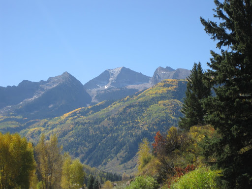
The classic view of Chair Mt from near Redstone.
If you have ever driven down 133 from Carbondale to Redstone or Marble and found yourself staring at Chair Mountain, then had to slam on your brakes because there are three deer standing in the middle of the road, this route might be for you. Chair Mt has access issues. Subdivisions, mines, ranches - lots of private property on the north and west sides. The drainages to the east contain cliff bands, waterfalls, and dense vegetation. This access and route have no such issues and wanders through public lands. But it is a bit long. I think it is about same effort as the standard route on Capitol Peak. Maybe a little more, I was a bit sore the day after.
Based on the sordid history of Chair Mountain and it's current status as a gem for poachers who like to trespass, I feel it is appropriate I name this route that requires no trespassing or permission.
We will name this route "Ceiliedh's High Chair Route" after our first child, a beautiful girl who died during or before birth after 5 months in the womb (21 weeks). She never got the chance to wander up a mountain or climb anything. But she has undoubtedly been reincarnated as a marmot and is, as you read, scaling vertical boulders just for fun. Ceiliedh is the Scottish and Irish word for "gathering". People get together, tell stories, sing songs, dance, and have a good time. We named our deceased daughter Ceiliedh because my parents through a ceilidh for us the day after our wedding in Seattle. Ceiliedh's ashes accompanied me to the summit.
Chair Mt from south of McClure Pass on 133. Chair Mt is in the center, ridge climbed is skyline right of summit.

The trailhead is the Ragged Mt Trail off of Kebler Pass Road (12). The trailhead is 2.3 miles from the Kebler Pass Road. Just west of Anthracite Creek take the Munsey Creek Road (FR759 on maps, marked as RF 795 off of 12). Drive for about 2.3 miles to the end of the road. Stay left at 1.8 miles and open and close a livestock gate at 2 miles. We made it in a Subaru Outback. The first section of the road is very narrow, if you encounter a vehicle coming down or up there will be an issue. This is a popular spot for hunters.
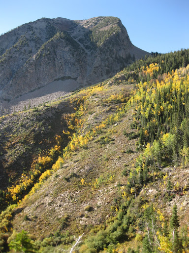
Looking up towards UN12480 from the Spud Pass Trail.
 >
>
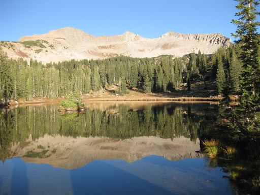
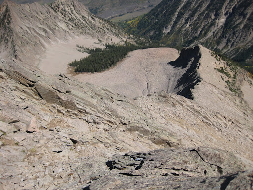
Deep Lakes
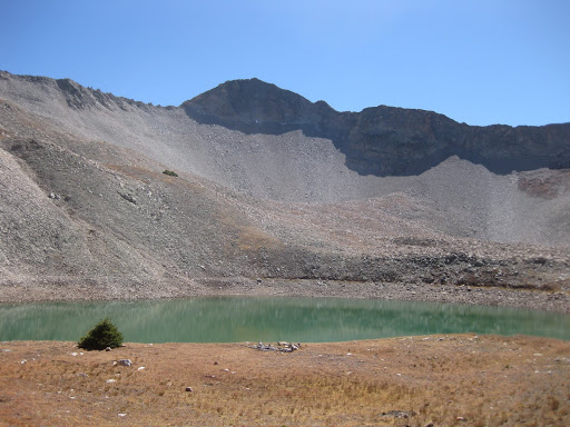
Follow the Ragged Mt Trail (#820, clearly marked) for about a mile. Turn northward at the sign for trail #824 (Spud Pass Trail). The sign claims Deep Lakes are 5 miles from this spot. The trail wanders through a picturesque Aspen forest, past stock ponds with cows happily grazing, meanders where down trees are not cleared, crosses to the west side of a creek, then goes steeply up hill. There are many switchbacks. The trail stays east to avoid ravines but loops west back toward Deep Lakes. The trailhead is at about elevation 7700. The lakes are at 11,000. We camped at a very nice spot at the smaller lake.
The smaller Deep Lake (which is very shallow) in the morning. We ascended the saddle just right of the peak in the center.
 >
>
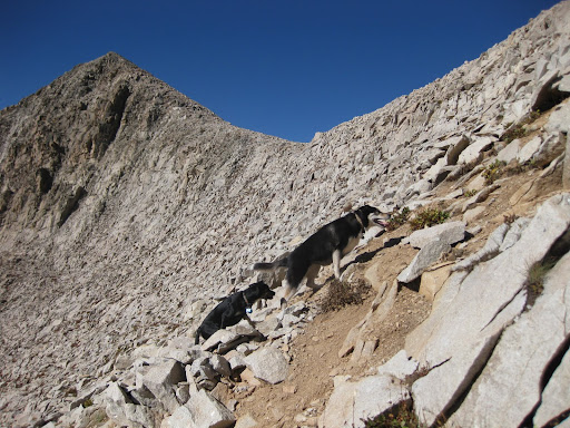
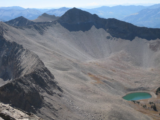
From the lakes, we wandered uphill to the pass just northeast of UN12480. We mosied across to the north face of UN12480. This is where Amanda and the dogs decided to turn back. We could see Chair Mt in the distance. I think she said something like "This is ridiculous. You are crazy." The climb to the saddle was class 2 and so was the easy scenic ridge over to the summit of Ragged Peak. From Ragged Peak to Chair Mt. is probably about 1.5 miles as the crow flies. Piece of cake.
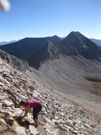
Climbing to the saddle.
From the saddle an easy ridge to Ragged Peak
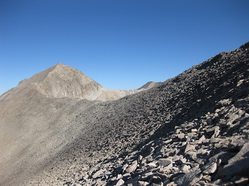
The descent off of Ragged Peak really felt like class 4. Cliffs are on both the north and east sides. The west side seemed to go nowhere. There is 200 or 300 vertical feet of class 3 or 4 stuff. From the base of the summit pyramid, options were to head down into Buck Creek Basin or meander along the ridge. I chose the ridge and made good time for about ¾ mile. Some class 3, but also plenty of nice class 2 jogging. Unfortunately, the easy stuff ended. The ridges are granite, but lots of loose granite. I tried to bail off the ridge but got scared by the looseness of the rock. I backtracked about a ¼ mile and descended a local ridge down into Buck Cr Basin.
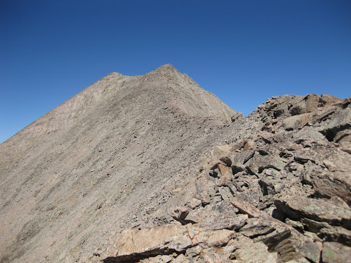
Ridge off of the summit of Ragged Peak
The class 4 ridge the summit pyramid of Ragged Peak

The ridge north of UN12,473. It turned me back.
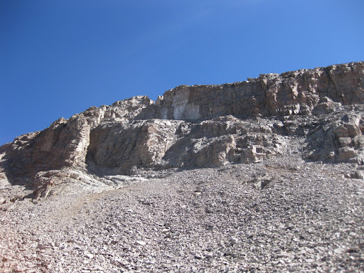
I traversed on the nice large talus over to the standard route used from Buck Creek and slogged up the incredibly loose approach to Chair's south ridge. If you end up there and try this, head for the obvious notch at the low point on the ridge. I went the way that looked easiest. At this point, I was almost glad to be the only person on the mountain. This is some loose stuff. Lots of rocks went tumbling. There is a brief class 3 section to attain the ridge.
From the saddle between UN12473 and Chair Mt. Easy going from here.
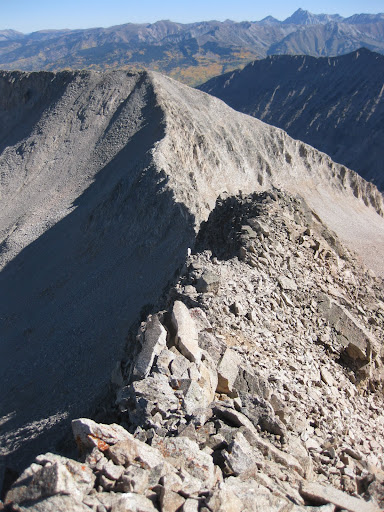
Once on the south ridge, it is class 2 ridge running at it's finest. Views of the Elks to the east are great. The ridge is nice and wide. An occasional boulder in the middle of the ridge could be tackled for a class 3 or 4 move. From the summit of Chair the world is a pretty place.
Ridge north of Chair to UN12374
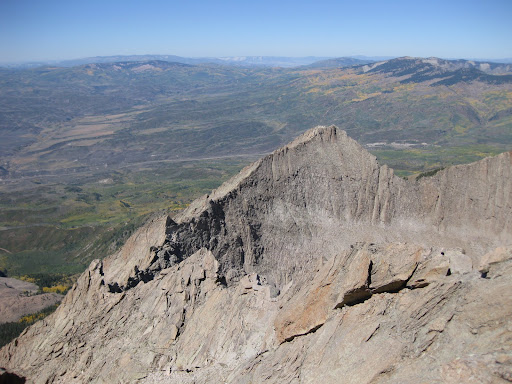

Capitol Peak from Chair Mt.
View from the top of the Northeast ridge on Chair, Class 4 route.
Now the only thing left to do is descend, then reclimb Ragged Peak, and get back to camp... Yeah, that's right. I could not find a way to get around the summit of Ragged Peak. Looks like the only reasonable route goes over the top. Maybe I could have traversed and not climbed the last 25 feet to the summit, but why?
View from Chair Mt to Ragged Peak.
My fate is to slog up the scree field, arrive left of the Ragged Peak summit pyramid, and reclimb Ragged Peak.
I descended to the lakes in Buck Creek to minimize my talus time, wandered through the meadows and past a lake, then slogged up the talus and scree slope to just below the Ragged Peak summit pyramid. I scrambled up the mostly class 3 pyramid. It seemed easier climbing than descending blind, but there was still a little class 4 the way I went.
Chair Mt from summit of Ragged Peak.

This entire route took me less than 8 hours round trip from our camp at the Deep Lakes.
I probably climbed something like 4,500 vertical feet from Deep Lakes and back.
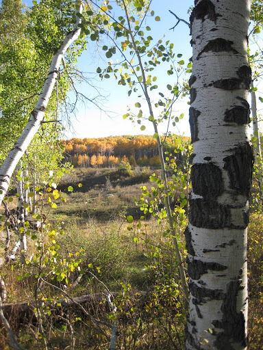
Some color on the hike out.
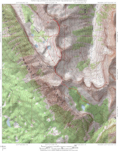
A map of my wanderings:
This route up Chair Mountain is rumored (rumors mostly spread by me, as far as I can tell) to have been climbed by coal miners from Somerset frequently until 1909. Those guys often wandered through the hills in search of mineral resources. Most of the guys who climbed from Somerset were just trying to find something to do except hang out in the one bar in town. There weren't many options for entertainment, so they often wandered far into the hills. My interpretation of the history of Colorado mountain climbing is based on random thoughts that come to me based on occasional conversations with people who might know. I haven't actually looked into any historical references or even tried to talk to people who would know about these things.
This route up Chair Mountain was probably the standard route to climb Chair Mountain up until the early 20th century. Then topographic maps became available, and people started climbing peaks based on elevation and not based on aesthetics. My uninformed guess is that this route has basically been thrown out and ignored since 1909. Usually, if a mountain isn't over 14,000 feet and it is a long drive it is ignored by the masses. Most of the hardcore peakbaggers ignore this mountain as well, because it is even lower than 13,000 feet.
In recent history, I've heard (or maybe just made up) that a really hard core team of extremely bad ass climbers ascended the North Face of Chair Mountain sometime between 1968 and 1970. The story is that they climbed in a leave no trace style, using only knotted cords for protection and they cleaned everything they placed. So there is no evidence of this climb. I don't know what they rated the climb. But I would guess they rated it 5.10. The team is rumored to have burnt their hemp climbing ropes on the summit as an offering to the earth goddess. Having no ropes, they could not descend their ascent route. They descended the route described in this writing. Oddly, since they climbed the north face, this face has transformed into a 70 degree choss pile, with millions of pizza box shaped rocks teetering on the face ready to go smash someone in the face.
Hearsay suggests that the first ascent of the North Face of Chair Mountain consisted of a team of Carl Blaurock, Layton Kor, Steve Burger, and Heinrich Majewski. Even though I know two of these individuals very well, details are sketchy at best and they deny any knowledge of the climb. They also probably weren't even in Colorado those years. Climbers have their secrets. What can you do? Maybe they discovered something on the top of Chair Mountain.
I went with a CMC group from a private cabin at the Ragged Mountain Reserve this summer to try to climb Chair Mt. This trip helped a lot with route information on what was feasible. We got great advice from our host but were too stubborn to follow it. Well, our only reasonable excuse is that the weather looked bad. Real bad. It rained very hard during the night before the climb. Both routes from the Ragged Mt. Reserve reportedly involve a lot of bushwhacking or talus hopping. We thought we'd try to stay dry and not break any ankles by ascending the NW ridge. We did manage to get to the summit of the right arm rest. We had incredible views of Chair, the subsummit west of Chair, and Elk Range. A really great hike but the ridge to the Chair subsummit and to Chair Mt from that approach is technical. A friend of mine says he heard somewhere that it goes about 5.7. But he can't remember where he heard that and isn't sure it's been climbed...
It should be possible to climb Chair Mountain from Anthracite Pass/Yule Creek trail. This route does not cross any private property. Our attempt was a total fiasco. Except we did get to the top of Ragged Mt, which is a neat place. I convinced two climbing partners of mine (Zach and Ben) that I knew what I was doing and that we could climb Chair Mt from Anthracite Pass. Zach and I ended up waiting at the Penny Hot Springs for a couple of beers until Ben showed up. We eventually got to the trailhead and even started hiking. We got to Anthracite Pass and successfully camped.
We even started up at a reasonable hour. It would have been a lot faster if we had known about the trail. Instead we took the ridge and lost 3 or 4 hours on difficult terrain. We were turned back by loose class 5 terrain. We ended up sidehilling and descending really nasty loose stuff. We found the trail and wandered into the Milton Creek drainage, just for fun. Great place. It took us almost 12 hrs to climb Ragged Mt from Anthracite Pass and get back to the car. If you didn't get lost and moved at my normal rate, you would probably get up and back to Ragged Mt. in 6 to 8 hours from Anthracite Pass.
I think that a very fast individual using a trained mountain goat as a guide could climb Chair Mt using this approach in a day, but they would need to cut through the Milton Creek and Rapid Creek drainages.
Follow the Yule Creek Trail for ¼ mile, then turn onto the Anthracite Trail. Follow this to Anthracite Pass. At the pass, go west on the trail up to the ridge. From the ridge, the trail connects to the Raspberry Creek Trail. Go south and then traverse west on the Raspberry Cr trail, if you can find it. If not, go the way we did on the ridge, which is slow and pretty tricky. Staying on the ridge seemed to be class 5, so we bailed off it. If you find the trail, it traverses the hillside to the pass east of Ragged Mt. From this pass, wander up the easy and scenic ridge to Ragged Mt if you have time. You would probably need to either go south around Ragged Mt into the Deep Creek drainage and meet up with the route described above or cut across Milton Creek and over to Rapid Creek drainage. It sort of looked to me like you could find a way across these drainages and over saddles. A lot of talus hopping would be called for. It would take some time. The ridges between these mountains are technical in multiple places.
|


