Download Agreement, Release, and Acknowledgement of Risk:
You (the person requesting this file download) fully understand mountain climbing ("Activity") involves risks and dangers of serious bodily injury, including permanent disability, paralysis, and death ("Risks") and you fully accept and assume all such risks and all responsibility for losses, costs, and damages you incur as a result of your participation in this Activity.
You acknowledge that information in the file you have chosen to download may not be accurate and may contain errors. You agree to assume all risks when using this information and agree to release and discharge 14ers.com, 14ers Inc. and the author(s) of such information (collectively, the "Released Parties").
You hereby discharge the Released Parties from all damages, actions, claims and liabilities of any nature, specifically including, but not limited to, damages, actions, claims and liabilities arising from or related to the negligence of the Released Parties. You further agree to indemnify, hold harmless and defend 14ers.com, 14ers Inc. and each of the other Released Parties from and against any loss, damage, liability and expense, including costs and attorney fees, incurred by 14ers.com, 14ers Inc. or any of the other Released Parties as a result of you using information provided on the 14ers.com or 14ers Inc. websites.
You have read this agreement, fully understand its terms and intend it to be a complete and unconditional release of all liability to the greatest extent allowed by law and agree that if any portion of this agreement is held to be invalid the balance, notwithstanding, shall continue in full force and effect.
By clicking "OK" you agree to these terms. If you DO NOT agree, click "Cancel"...
On Wednesday, September 1, 2010, I climbed Capitol alone in a relatively mad rush to finish the 14ers. Finishing the 14ers was a really fun and wonderful accomplishment, but there was a different, and personally more important goal also within close reach. Climbing Capitol put my peak count at 99 of 100 of the State's 100 highest peaks. Why the push to get Capitol? Simple. Erik Kling, one of my friends, was also at 99 of the 100 highest, and we had the same peak, Vestal, as the remaining unclimbed peak. Earlier in the summer, we hatched plans to finish the 100 highest together on Vestal Peak over Labor Day weekend.
Friday 9/3/10:
I awoke at 6:30 a.m., took a shower, and threw my pack in my truck. I headed out over Cinnamon Pass to meet Erik and Tom Courtright at the Molas Pass Trailhead south of Silverton. We met up at 9:15 a.m., and while in the parking lot, made the final adjustments to our gear, sorting out what gear would be shared during the pack in.
Tom and Erik packing up for Vestal Basin.
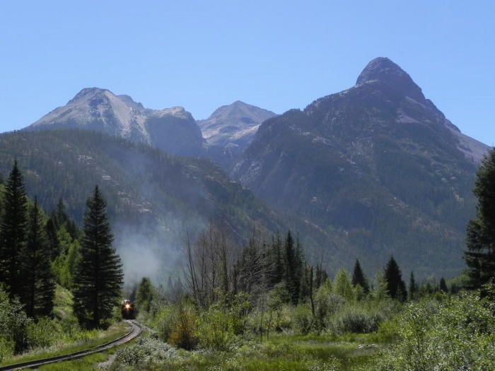
All extra space in our packs was filled with cans and bottles of tasty beverages. We started the hike into the Grenadier Range at 10:00 a.m. The hike in went smoothly and we were able to watch one of the trains puff by as we crossed the tracks to get onto the Elk Creek trail.
The train passing through on the way in.
The hike to our high camp beneath Vestal consisted of 8.2 miles and about 3,000 feet of elevation gain. We arrived at camp at 4:00 p.m., happy to be free of the pigs that most people call backpacks. We sipped some Gubna IPA and basked in the astounding view of Vestal as it loomed tall above our camp. While we taking in the view, a herd of mountain goats invaded our camp.
Goats and Gubna. Photo by Erik Kling.
They were so aggressive that we were afraid the goats might get tangled up in our tent cords. They were obviously salt hungry, and were looking for urine. That night we slept well.
Vestal and a urine-hungry mountain goat.
Saturday 9/4/10:
There were a few other parties in the basin that weekend with similar goals. We awoke at 6:00 a.m., had a short breakfast, and were hiking towards Vestal by 6:30. As we approached the base of the Wham Ridge, we were awestruck at how much the face looked like a huge curling wave of rock that was getting ready to break over us.
The curling quartzite wave of Wham Ridge.
We followed the immediate western edge of the face that Roach rates 5.3 in his 13ers book. This lower section was nowhere near that difficult, and made for a speedy approach to the grassy ledges higher up on the face. We unpacked and put our climbing gear on while at the famous grassy ledge, and then continued to solo up about 2-3 pitches until the rock started to get steeper.
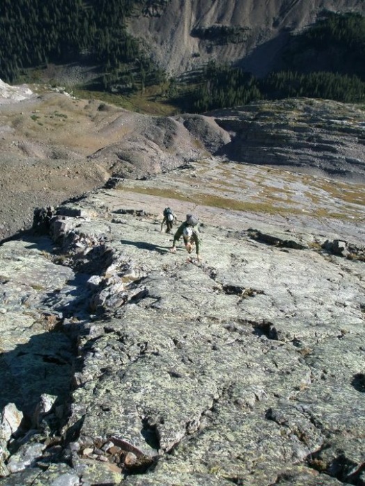
Soloing the first few pitches above the grassy ledge. Photo by Erik Kling.
Once there, I found a nice ledge and made an anchor, and we flaked the rope and tied in. Tom and Erik tied into the other end very close together, and I led about 9 pitches to the top of the major false summit of the peak with them following.
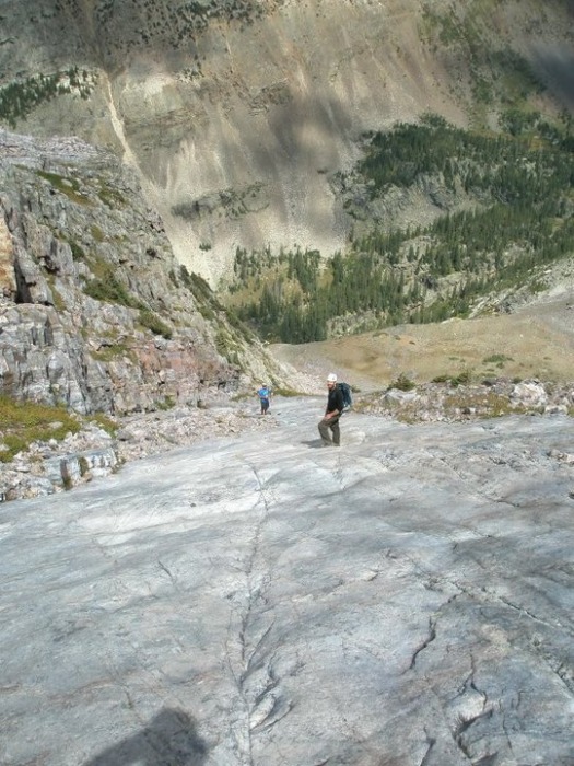
Patrick leading the Wham headwall. Photo by Tom Courtright.
From there we un-roped and traversed over to the true summit bypassing a sketchy looking chockstone. Upon closer inspection, the chockstone seemed to be pretty solid. We arrived on the summit a little after 10:00 a.m. For the climb I used a light rack of 6 stoppers and the smallest 6 Tricams. I rounded out our rack with 10 shoulder slings, four quickdraws, and 6 free oval carabiners. This rack proved to be completely adequate, and I would recommend it to future parties who wish to climb the Wham Ridge roped.
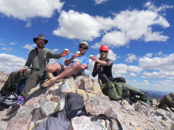
Once on the summit of Vestal Erik Kling surprised Tom and I with a cold bottle of Damnation Golden Ale and three plastic goblets. He doled out the beer, and we toasted to finishing the 100 highest peaks in Colorado (Tom is almost there at 91/100).
Tom, Patrick, and Erik toasting finishing the 100 highest.
After taking obligatory summit photos and having a snack, we packed away our climbing gear and proceeded to descend the easier southern route on the peak. Roach rates this descent at Class 2+, but it was clearly evident that it was solid third class, as we were using our hands quite a bit during the descent. We wrapped around the back of Vestal to the reportedly dreadful scree that fills the saddle between Vestal and Arrow Peaks. We arrived at the saddle and saw the scree. We ended up scree surfing down, glad that we did not ascend this way. We found ourselves at the base of the rock ramp of Arrow at about 12:30.
The ascent up Arrow went quickly as the rock ramp is clean and high friction.
Working our way up Arrow's ramp. Photo by Erik Kling.
We topped out at about 1:30 and took in the astounding views of Vestal. I can't think of a better perch to take in our earlier climb of Vestal.
Kicking back on Arrow.
We continued to have stellar weather, and relaxed for a while on the summit. We descended back to camp and arrived at 3:30. We celebrated with cold cans of Ten Fidy, Gubna, a bottle of Colorado Whiskey that I had brought in as a surprise, and a bottle of Full Sail Imperial Porter from Burbon Casks that Kling hadn't told us about. We ate and slept like kings.
9/5/10:
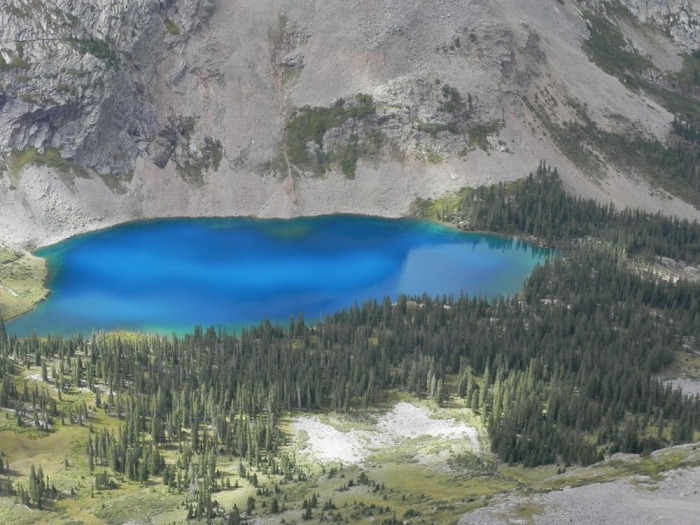
We slept in a bit this morning and started hiking towards the Trinities at about 8:30 a.m. The upper portions of the Vestal Basin are wonderful, as you gain new perspective on Arrow, Vestal, and the three Trinities. We reached the eastern saddle between Vestal and West Trinity and launched up West Trinity's southwest ridge until we topped out. Near the top, Balsam Lake, which is south of the Trinities came into view, and its beauty stunned us all. It is without question the most beautiful lake that I have come across in the highcountry.
The wildly iridescent Balsam Lake.
From the summit of West Trinity, the knife edge between it and Trinity Peak was obvious and somewhat intimidating.
The knife-edged ridge between West Trinity and Trinity Peaks.
Luckily, the route does not follow this knife edge, but skirts south of and below it. Once past the obvious edge, we started to scramble back up to the ridge between the two peaks and ascended an easy and obvious chimney to regain the ridge. We were on the summit of Trinity peak soon after. As I neared the summit of Trinity, I looked back at Tom and Erik as they were passing a point on the connecting ridge. Their position made for a great mountaineering photo.
Tom and Erik back on the Trinity Peak knife edge ridge.
The last part of the Trinity Traverse consists essentially of descending a rubble filled gully down the east side of Trinity peak to the saddle between Trinity and East Trinity Peak. The same gully continues up East Trinity, and the route finding in the gully is simple and straight forward.
The rubble-filled gully between Trinity and East Trinity Peaks. Photo by Erik Kling.
Once on the summit of East Trinity, the hard hiking is over, and we were able to relax. We descended the northeast ridge of East Trinity through the shale beds until we reached the East Trinity - Peak Three saddle. From there is was an easy jaunt back to camp, where we arrived at 1:30. The views on the way back were phenomenal.
View of the Trinities.
View of Vestal and Arrow on the way back to camp.
We again soothed our legs with tasty libations, napped, and ate copious amounts of food. The following day we packed up and made the relatively easy hike out to Molas Pass, where we packed up our cars and headed to Silverton for a big lunch at Handlebar's.
In all, I can't think of a better peak and route to finish the 100 highest on than Vestal's Wham Ridge. The climbing is truly easy, and if everyone in your party feels competent, soloing is not a ridiculous proposition by any means. If you have ever soloed the first or third flatiron and felt comfortable, then you will be fine cordless on the Wham Ridge.
Finally, I wanted to give special props to both Tom Courtright and Erik Kling. I have had countless incredibly fun days hiking, climbing, skiing, and partying with both of you, and I look forward to rounding out the 200 highest with you both. I am also looking forward to celebrating you both finishing riding the 14ers, which should occur in Spring of 2011. Thanks Homies.
Thumbnails for uploaded photos (click to open slideshow):
Wow - Amazing photos, a fine selection of ales, finishing the Centennials... this trip report has it all! Looks like you guys had a great time. Congratulations on a huge accomplishment.
is a fine wilderness setting and a damn cold lake to take a dip in, but revives the spirits after a tough pack in to that region. I think the most impressive part of this trip is the packing in of the beer to a basin so deep in the Weminuche.
Congrats Patrick. What a great route to complete the 100 list with! And great 2010 SJS shirt. Love that one.
I'm at 98/100 and hope to climb the last two, Hagerman and Cathedral, in the spring. I'm inspired by your summit beers--I'll have to do the same. Now to decide which canned beer to take? Fat Tire or Moose Drool?
My favorite range in the state (sigh). I concur that your group has great taste in beer (as they do in summits). Congrats on the centennials. Thanks for posting. Happy trails! :D
Caution: The information contained in this report may not be accurate and should not be the only resource used in preparation for your climb. Failure to have the necessary experience, physical conditioning, supplies or equipment can result in injury or death. 14ers.com and the author(s) of this report provide no warranties, either express or implied, that the information provided is accurate or reliable. By using the information provided, you agree to indemnify and hold harmless 14ers.com and the report author(s) with respect to any claims and demands against them, including any attorney fees and expenses. Please read the 14ers.com Safety and Disclaimer pages for more information.
Please respect private property: 14ers.com supports the rights of private landowners to determine how and by whom their land will be used. In Colorado, it is your responsibility to determine if land is private and to obtain the appropriate permission before entering the property.


 Tom and Erik packing up for Vestal Basin.")
 The train passing through on the way in.")
 Goats and Gubna. Photo by Erik Kling.")
 Vestal and a urine-hungry mountain goat.")
 The curling quartzite wave of Wham Ridge.")
 Soloing the first few pitches above the grassy ledge. Photo by Erik Kling.")
 Patrick leading the Wham headwall. Photo by Tom Courtright.")
 Tom, Patrick, and Erik toasting finishing the 100 highest.")
 Working our way up Arrow's ramp. Photo by Erik Kling.")
 Kicking back on Arrow.")
 The wildly iridescent Balsam Lake.")
 The knife-edged ridge between West Trinity and Trinity Peaks.")
 Tom and Erik back on the Trinity Peak knife edge ridge.")
 The rubble-filled gully between Trinity and East Trinity Peaks. Photo by Erik Kling.")
 View of the Trinities.")
 View of Vestal and Arrow on the way back to camp.")