Download Agreement, Release, and Acknowledgement of Risk:
You (the person requesting this file download) fully understand mountain climbing ("Activity") involves risks and dangers of serious bodily injury, including permanent disability, paralysis, and death ("Risks") and you fully accept and assume all such risks and all responsibility for losses, costs, and damages you incur as a result of your participation in this Activity.
You acknowledge that information in the file you have chosen to download may not be accurate and may contain errors. You agree to assume all risks when using this information and agree to release and discharge 14ers.com, 14ers Inc. and the author(s) of such information (collectively, the "Released Parties").
You hereby discharge the Released Parties from all damages, actions, claims and liabilities of any nature, specifically including, but not limited to, damages, actions, claims and liabilities arising from or related to the negligence of the Released Parties. You further agree to indemnify, hold harmless and defend 14ers.com, 14ers Inc. and each of the other Released Parties from and against any loss, damage, liability and expense, including costs and attorney fees, incurred by 14ers.com, 14ers Inc. or any of the other Released Parties as a result of you using information provided on the 14ers.com or 14ers Inc. websites.
You have read this agreement, fully understand its terms and intend it to be a complete and unconditional release of all liability to the greatest extent allowed by law and agree that if any portion of this agreement is held to be invalid the balance, notwithstanding, shall continue in full force and effect.
By clicking "OK" you agree to these terms. If you DO NOT agree, click "Cancel"...
Quick Note: Be sure to check out Youtube videos attached at the end of this report!
A friend of mine and I returned to the Coast Guard Academy mid-August to start our senior year. We had both spent some time in Colorado this summer (home for me, family for him) and spent most of our time backpacking/climbing. After only a couple weeks of school we both decided we had to get back to that Rocky Mountain High. A friend of mine had Wilson Peak as one of a handful remaining on his list. Seeing that we had a long weekend because of Labor Day, we decided to make the journey from New London, CT to Telluride, CO to make the climb with him and one of his friends. Now, onto the meat of the climb....
Nate and I arrived at DIA at 11pm on 03SEPT2010. My family was out of town so we picked up a rental car and made the quick trek to Monument for a quick night's rest. Woke up at 0700 on Saturday to rendevous with Phil and Greg and left for Telluride around 0800. After a quick stop in Salida and Ridgeway, we arrived at the Bilk Basin trailhead (labeled Lizard Head TH) at about 1600 Bilk Basin (Lizard Head) Trailhead. See this link for info on getting to the TH: Getting to Bilk TH
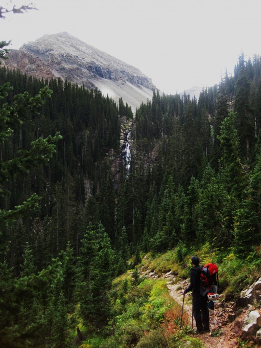
Once you arrive at the trailhead start following the easy trail (flat for about 1.5 miles). The trail eventually seems to come to an end before it crosses bilk creek (some flat wood pieces are laid for the crossing and the trail reappears). The elevation begins to increase with switchbacks after the crossing. The scenerey here is amazing! After the crossing Bilk Creek and looking back.. Continue hiking up until you eventually reach timberline. After the crossing, you will see some old wreckage of a trailer and an option to turn right or left. Stay left and keep climbing up (this intersection is pretty obvious).
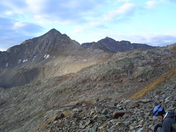
After gaining elevation to timberline, you will begin to see more trail high and to your right (North). You have the choice to take it easy on the switchbacks or cut over some loose rock to gain elevation quicker (be sure not to head to Lizard Head). Approaching timberline where it is a must to stay right to get to Bilk Basin. After about another 1 or 2 miles from this picture you will crest a ridge and be able to look down (about 100ft) at Bilk Basin. Here is a picture of the basin from further up on the trail. Looking back at Bilk Basin
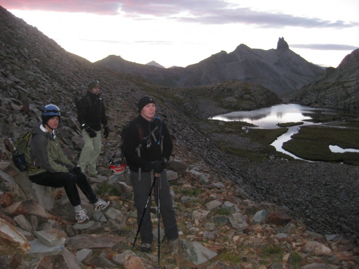
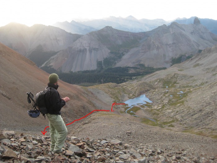
We set up camp just before sunset and we were able to use the lake and creek to refill our water supply. After getting all set up we decided that we would get up at 0530 (a bit later than the usual 0400 wake-ups) and head for the summit. The weather was most excellent and we were even able to start a small fire to examine next day's route exactly.
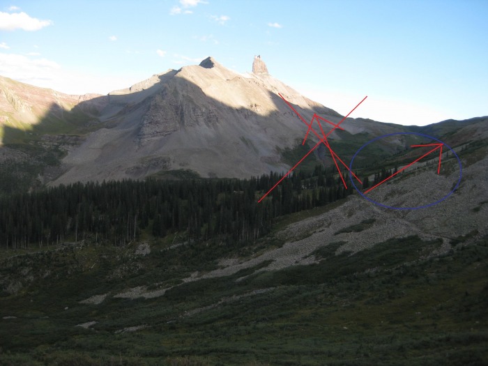
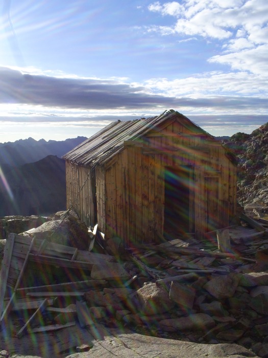
After a good night's rest, we woke up at 0530 and took our time getting ready and eating breakfast. It's amazing that after so much traveling to get to base camp, I now actually felt the least rushed out of the entire trip. We hit the trail at about 0630 (yes, we REALLY did take our time getting ready) and once again we were delighted with the perfect weather. Once on the trail again, head up towards the loose rock as pictured and eventually head south towards the ridge between Gladstone Peak and Wilson.Leaving Bilk Basin Heading towards the saddle. You will approach some miner wreckage where you start to go around the mountain on your final approach to the saddle. Some old miner wreckage. As you get within a couple hundred feet (elevation) of the saddle, you will be able to see an old miners house.Looking at the Miners Cabin before heading to the saddle. This makes for a great stop before the climb begins to enter Class 3 terrain. If you ever needed to hunker down here, this a great place to do so before getting stuck up high on the Class 3 portion of the mountain. Again, here is a quick look back at the route up from the basin. Another look at the route thus far.
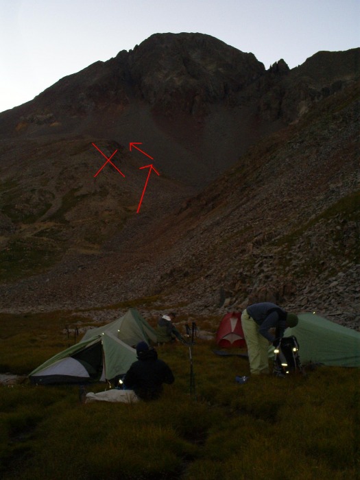
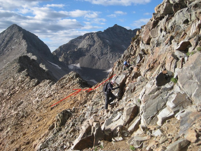
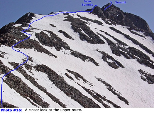
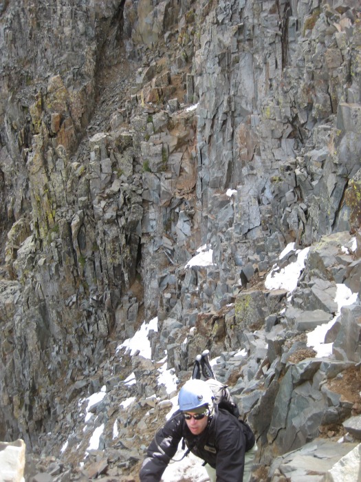
From the cabin, you can look up (West) towards the saddle between Gladstone and Wilson and you should be able to see a Cairn if you look closely. Head to that (it takes about 10 minutes from the cabin). From here, head up the ridge to Wilson (some class 3 moves required here depending on the route you take). Here you can see the top of the saddle (from the ridge leading to the Summit). From the saddle, things start to get a little tricky. Now, as pictured in the 14ers.com trip report, make this rout to the false summit, (the beginning of the crux). The remaining route (not my picture here).
From the false summit, you can see the remaining route to the summit. Just drop about 50ft to the coulier pictured. A look at the crux of the climb. After you follow this, you will have a quick scramble left. This is what it looks like climbing down from the false summit. Heading down the false summit enrout to the coulier. Here is some moves over to the coulier. Climbing over to the coulier. Here is a quick look up the coulier.Climbing down the coulier. By now your heart is racing from the exposure and the remaining scramble usually becomes a rock hop sprint.
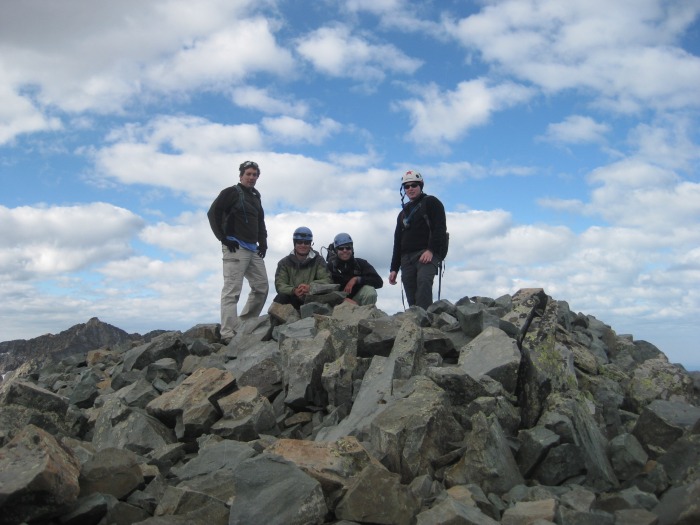
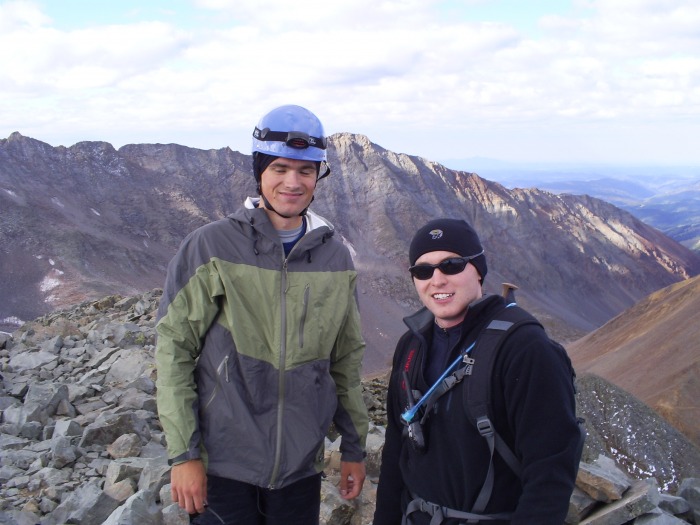
TOP OUT! Phil and I on the SummitGroup ShotNate and I
After climbing back down, it was off to the airport to catch our flight back to school. Won't be back until Christmas.
Thumbnails for uploaded photos (click to open slideshow):
My Dad and I tried to do the whole thing all the way from the trailhead. We made it just above the cabin by 11 or so but the weather wasn't cooperating so we turned back. The fog cleared later and we saw how much climbing we would have had....good choice camping at the lake! This is a looong hike from the trailhead
I wouldnt be able to do that technical of a hike....but it looks awesome! Thanks for posting! And for the photo too! :D . I added the credit!
Caution: The information contained in this report may not be accurate and should not be the only resource used in preparation for your climb. Failure to have the necessary experience, physical conditioning, supplies or equipment can result in injury or death. 14ers.com and the author(s) of this report provide no warranties, either express or implied, that the information provided is accurate or reliable. By using the information provided, you agree to indemnify and hold harmless 14ers.com and the report author(s) with respect to any claims and demands against them, including any attorney fees and expenses. Please read the 14ers.com Safety and Disclaimer pages for more information.
Please respect private property: 14ers.com supports the rights of private landowners to determine how and by whom their land will be used. In Colorado, it is your responsibility to determine if land is private and to obtain the appropriate permission before entering the property.