Download Agreement, Release, and Acknowledgement of Risk:
You (the person requesting this file download) fully understand mountain climbing ("Activity") involves risks and dangers of serious bodily injury, including permanent disability, paralysis, and death ("Risks") and you fully accept and assume all such risks and all responsibility for losses, costs, and damages you incur as a result of your participation in this Activity.
You acknowledge that information in the file you have chosen to download may not be accurate and may contain errors. You agree to assume all risks when using this information and agree to release and discharge 14ers.com, 14ers Inc. and the author(s) of such information (collectively, the "Released Parties").
You hereby discharge the Released Parties from all damages, actions, claims and liabilities of any nature, specifically including, but not limited to, damages, actions, claims and liabilities arising from or related to the negligence of the Released Parties. You further agree to indemnify, hold harmless and defend 14ers.com, 14ers Inc. and each of the other Released Parties from and against any loss, damage, liability and expense, including costs and attorney fees, incurred by 14ers.com, 14ers Inc. or any of the other Released Parties as a result of you using information provided on the 14ers.com or 14ers Inc. websites.
You have read this agreement, fully understand its terms and intend it to be a complete and unconditional release of all liability to the greatest extent allowed by law and agree that if any portion of this agreement is held to be invalid the balance, notwithstanding, shall continue in full force and effect.
By clicking "OK" you agree to these terms. If you DO NOT agree, click "Cancel"...
Flew in this time, so stayed at the Best Western in Alamosa. Suitable place on the main drag on the west side of town with pool and hot tub.
Getting there: The best rental vehicle I could get this time was a 4WD Ford Explorer--which is not a particularly suitable vehicle for Lake Como Road. The drive to the paved road turn-off took about 20 minutes via US 160, then 3 miles north on CO 150 to the turn off. This starts as an easy drive at 8,000', then becomes progressively rougher. 2WD passenger vehicles will likely need to park about 2 miles in. Standard street 4WD vehicles can go 3-4 miles. The Ford explorer could not take an obstacle at 9,500', so I had to back down to 9,400' (4 miles in). High ground clearance off-road vehicles, with some driver skill, can make it to somewhere between 10,200' and 10,500'. At 10,500' (Jaws 1) there is an effective rock blockade that will require a heavily modified vehicle, driver skill, and some significant risk to cross. There will be successive and significant road challenges ahead, so unless one simply wants to test a tricked-out vehicle and driver against the road, I would consider 10,500' the practicable limit for a stock off-road, high ground clearance, 4WD vehicle.
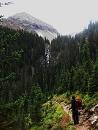
The hike in from 9,400' to Lake Como at 11,750' took about two hours in the predawn darkness and over the rough underfoot conditions. I arrived at the lake at first light. Strong, moist winds were blowing out of the San Luis Valley--obscuring and condensing on the peaks. As I learned later, this created 1/4" of ice and a few inches of snow above 13K. Above the lake lay two headwall structures. These look a bit intimidating at first, but they are easily navigable and are cairned. The Tuesday of my hike I expected it to be a light day. In fact, there were only two other parties on the mountain that day and the first party aborted their summit attempt due to icy conditions.
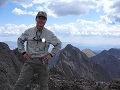
After Lake Como, you will easily transit Blue Lakes and, finally, Crater Lake at the base of the Blanca massif. Above Crater Lake you will be looking at a steep talus ascent. Again, it appears to be more intimidating than actual. On final approach to the summit you can either ride the ridge with exposure to the east, or stay below the ridge to the west. The ice and snow required careful route finding among the series of ledges near the summit and crampons would have been welcome--but my trekking pole served adequately. Ice and snow on this peak raise difficulty and risk significantly. Once on the cold, windy, and intermittently cloudy summit, Little Bear, Ellingwood, Lindsey, and the beautiful surroundings came into full view.
I expected the traverse to Ellingwood to take at least 90 minutes, but it only took about 45 minutes. Given the icy conditions on the NW face of Blanca I chose to descend directly down the top of the ridge, with some exposure to the east. Toward the saddle, the sun had melted the ice and things went much quicker. I traversed the west side of the ridge at roughly 13,600'. There are intermittent cairns, but you can just select your own route--crossing ribs, washes and ledges enroute. This is mostly a Class 2 traverse, with a bit of Class 3 scrambling from time-to-time. Nothing especially difficult. Likewise, on ascent of Ellingwood, the bark is worse than the bite. Pictures look a bit intimidating, but it is just a standard Class 2 ascent with a small amount of scrambling near the top. On descent from Ellingwood, you will need to carry back toward the saddle to avoid the difficulties of very steep loose material. You may choose the line of your own comfort.
This double is a long day if you don't have a vehicle that can get above 10K or don't overnight. It is not so much the elevation gain as it is total distance and poor underfoot conditions on much of the road. The western slopes really heat up on summer afternoons, so make sure you have adequate fluid for departure. I went through two liters of fluid for the day.
All-in-all, a beautiful day.
To display your photos (uploaded below) in the final trip report, type the image number (i.e., 1, 2, 3), highlight it with your cursor, and click on the Image button on the right. Example: View of approach from Lake Como area
Thumbnails for uploaded photos (click to open slideshow):
Flew in from Illinois (elevation ~700'). I have somehow been very fortunate over the years in not having a single turn-back in 35 attempts due to weather or health-related issues.
On this one, no crowds, no mosquitoes, and reasonable temps.
Caution: The information contained in this report may not be accurate and should not be the only resource used in preparation for your climb. Failure to have the necessary experience, physical conditioning, supplies or equipment can result in injury or death. 14ers.com and the author(s) of this report provide no warranties, either express or implied, that the information provided is accurate or reliable. By using the information provided, you agree to indemnify and hold harmless 14ers.com and the report author(s) with respect to any claims and demands against them, including any attorney fees and expenses. Please read the 14ers.com Safety and Disclaimer pages for more information.
Please respect private property: 14ers.com supports the rights of private landowners to determine how and by whom their land will be used. In Colorado, it is your responsibility to determine if land is private and to obtain the appropriate permission before entering the property.

 Talus ascent of Blanca")
 Ascent face of Blanca")
 Ellingwood from ridge")
 Blanca-Ellingwood traverse")
 Huerfano Valley from Blanca")
 Little Bear from Ellingwood")
 View down the Como valley from Blanca ridge")
 Upper lakes of Como valley")
 Jaws 1 (more difficult than it appears)")