Download Agreement, Release, and Acknowledgement of Risk:
You (the person requesting this file download) fully understand mountain climbing ("Activity") involves risks and dangers of serious bodily injury, including permanent disability, paralysis, and death ("Risks") and you fully accept and assume all such risks and all responsibility for losses, costs, and damages you incur as a result of your participation in this Activity.
You acknowledge that information in the file you have chosen to download may not be accurate and may contain errors. You agree to assume all risks when using this information and agree to release and discharge 14ers.com, 14ers Inc. and the author(s) of such information (collectively, the "Released Parties").
You hereby discharge the Released Parties from all damages, actions, claims and liabilities of any nature, specifically including, but not limited to, damages, actions, claims and liabilities arising from or related to the negligence of the Released Parties. You further agree to indemnify, hold harmless and defend 14ers.com, 14ers Inc. and each of the other Released Parties from and against any loss, damage, liability and expense, including costs and attorney fees, incurred by 14ers.com, 14ers Inc. or any of the other Released Parties as a result of you using information provided on the 14ers.com or 14ers Inc. websites.
You have read this agreement, fully understand its terms and intend it to be a complete and unconditional release of all liability to the greatest extent allowed by law and agree that if any portion of this agreement is held to be invalid the balance, notwithstanding, shall continue in full force and effect.
By clicking "OK" you agree to these terms. If you DO NOT agree, click "Cancel"...
Climbing Ellingwood Point via S. Zapata Lake Trail
After reading numerous accounts and hearing personal reports of just how lousy the Como Lake "road" is, my objective has been to climb all of the Blanca Massif by avoiding this so-called road and its attendant crowds. Over the years, we have managed to do just that, with a very long route up Blanca that is the start of the Gash route from the North, then descends to the Winchell Lakes and continues up an east ramp (a "variation" climb in Roach's book). No Como Lake road there! Then, our take on Little Bear also avoided the "road" as well as the dreaded hourglass: The SW ridge route, a long, hot, thorny passage complete with a short knife edge and questionable private property access. But no Como. And, we have avoided technical routes. Route from Zapata Falls follows a good trail to the lake
That left Ellingwood Point. After spotting a couple of reports (esp. "Mike Mc" in Summitpost.org "Caught in the Crossfire") on a potential new route, and studying topos of the area, it was decided to attempt the South Zapata Lake trail route, via a backpack to the lake for an early summit attempt the next day. Great Sand Dunes below
Of course, one must stop 0.5 mile in to peer at icy Zapata Falls, which requires getting a bit wet. Icy Zapata Falls
We passed some old cabin ruins, one of which was very intact. Honey, I'm Home!
Along the way, we spy our destination: Ellingwood We're climbing THAT?!
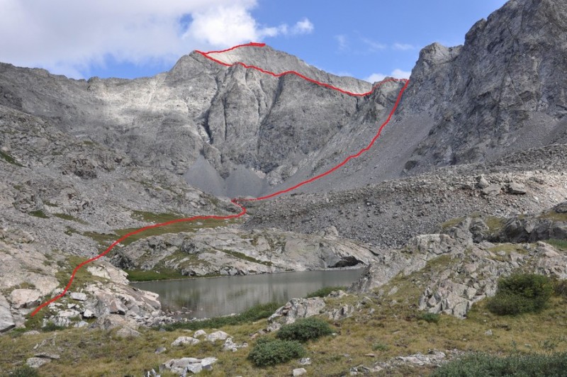
After a steady 4.6 mile hike (from the parking lot), with a couple of unfortunate downhill sections, we arrive at the lake. S. Zapata Lake with Route in Red No one around but marmots
It was very cold and windy, so after a quick meal and some filtering, we decided the sleeping bags sounded pretty good. And then we all fell asleep at a ridiculous 7:30pm. At first light and some yummy oatmeal, we headed off toward the scree slope mentioned in the noted article. They ascended the dark couloir (which they named "Crossfire Couloir") but after studying the slope, we decided to ascend the gully to the right (west) of their couloir, which was a mix of talus, boulders, scree and solid rock. Not much fun, but nothing insurmountable. I'd like to label it "C2" after my dear friend and climbing partner, Craig Clanton (now deceased), who would have been on this trip, but was undergoing chemo for leukemia. (He actually goes by the C2 symbol, plus, it does resemble the Crossfire Couloir double "C's"). His son, Cody was with me, however. The "C2 Couloir", adjacent to the "Crossfire Couloir" 2 steps up, one back...
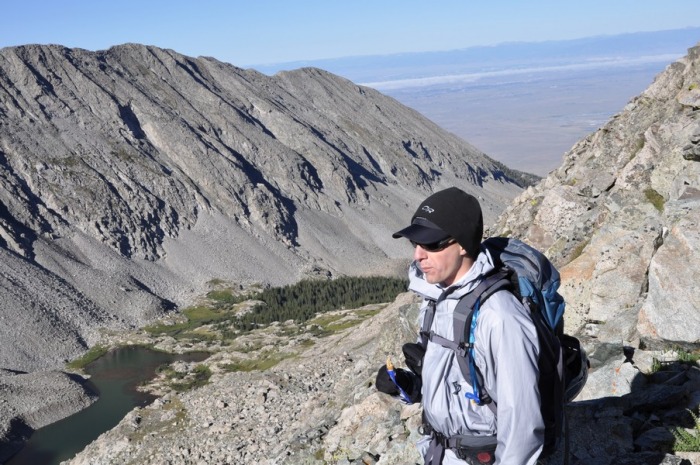
Finally, we make the ridge. To the west is Twin Peaks, to the east (left) the north ridge of Ellingwood. Below us is Pioneer Lake drainage. Cody peering down toward Pioneer Lake
Once on this ridge, progress is swift, until we reached the proper north ridge leading to the summit. It is here we encountered slower going due not so much to technical terrain, but rather all the rocks in shadow were coated in a layer of clear rime ICE. The easy part, until the ICE
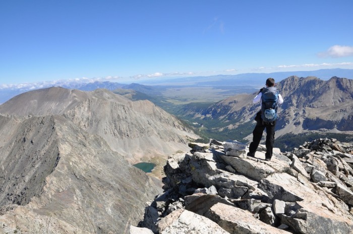
After descending slightly to our right (west) just before the summit, we gained what appeared to be the "regular" route from the, you know, ROAD. And then, the summit! (Mileage from lake to summit is approx. 1.4 miles.) Cody enjoying the sweet summit Yours truly with Blanca looming in back. I look like a conehead.
We still had to return to our tent, break camp, and backpack out the 4.6 miles. It took us 4 hours from tent to summit, 2 hours back (ice was better!) and 2 ½ hours to the car. Of course, we're flatlanders....
All in all a great alternative to the, ahem, road and the crowds. And we had the whole place to ourselves.
Thumbnails for uploaded photos (click to open slideshow):
I love those mountains, and I've looked at the Zapata trail on the map...thanks for the info. I'd also be interested to learn the details of the ”Como-free” Little Bear...
I had always understood that there was no route up Ellingwood from this side that didn't involve Class 5--but I see no mention of ropes in your report. This is way cool; I just wish I'd known it before we slogged up the standard route last year!
Marmot72: There's at least one report on SP. The route is, as noted, long and difficult, with serious route-finding issues.
cftbq, I believe the technical routes you are referring to is in the Huerfano drainage, which starts due north of Blanca and heads west up a difficult cliff section. Our route is NW of this in the Zapata drainage and is, as far as I know, not described in any route book. We didn't encounter anything more than Class 3 with some nice exposure in places. Except for the first slope, it's a lot of fun.
Thanks for a nice report, great pictures and a wonderful alternative to como.
Years ago, we went in to the basin just south of little bear. Had to get permission to cross private property.
We then ascended south little bear, traversed to little bear and returned the same way.
It was great, no como road, no crowds at all. Just our party of 4.
Thanks again.
Caution: The information contained in this report may not be accurate and should not be the only resource used in preparation for your climb. Failure to have the necessary experience, physical conditioning, supplies or equipment can result in injury or death. 14ers.com and the author(s) of this report provide no warranties, either express or implied, that the information provided is accurate or reliable. By using the information provided, you agree to indemnify and hold harmless 14ers.com and the report author(s) with respect to any claims and demands against them, including any attorney fees and expenses. Please read the 14ers.com Safety and Disclaimer pages for more information.
Please respect private property: 14ers.com supports the rights of private landowners to determine how and by whom their land will be used. In Colorado, it is your responsibility to determine if land is private and to obtain the appropriate permission before entering the property.


 Great Sand Dunes below")
 Icy Zapata Falls")
 Honey, I'm Home!")
 We're climbing THAT?!")
 No one around but marmots")
 2 steps up, one back...")
 Cody peering down toward Pioneer Lake")
 The easy part, until the ICE")
 Cody enjoying the sweet summit")
 Yours truly with Blanca looming in back. I look like a conehead.")
 S. Zapata Lake with Route in Red")
 The")
 Route from Zapata Falls follows a good trail to the lake")


