Download Agreement, Release, and Acknowledgement of Risk:
You (the person requesting this file download) fully understand mountain climbing ("Activity") involves risks and dangers of serious bodily injury, including permanent disability, paralysis, and death ("Risks") and you fully accept and assume all such risks and all responsibility for losses, costs, and damages you incur as a result of your participation in this Activity.
You acknowledge that information in the file you have chosen to download may not be accurate and may contain errors. You agree to assume all risks when using this information and agree to release and discharge 14ers.com, 14ers Inc. and the author(s) of such information (collectively, the "Released Parties").
You hereby discharge the Released Parties from all damages, actions, claims and liabilities of any nature, specifically including, but not limited to, damages, actions, claims and liabilities arising from or related to the negligence of the Released Parties. You further agree to indemnify, hold harmless and defend 14ers.com, 14ers Inc. and each of the other Released Parties from and against any loss, damage, liability and expense, including costs and attorney fees, incurred by 14ers.com, 14ers Inc. or any of the other Released Parties as a result of you using information provided on the 14ers.com or 14ers Inc. websites.
You have read this agreement, fully understand its terms and intend it to be a complete and unconditional release of all liability to the greatest extent allowed by law and agree that if any portion of this agreement is held to be invalid the balance, notwithstanding, shall continue in full force and effect.
By clicking "OK" you agree to these terms. If you DO NOT agree, click "Cancel"...
Our original plan had been to attempt the LB-Blanca traverse, but given the recent weather and iffy forecast, we opted instead for Ellingwood-Blanca on Friday and LB on Saturday. Neither of us were excited about the Hourglass, so we decided to ascend LB via the Northwest Face route. We took a rope and light rack in case, but didn't need the gear (it would be hard to find good gear placements on the Northwest Face).
It was raining when we drove to a nice parking spot near the bottom of the Lake Como Road (Never having been on the road, we were unsure as to what to expect, so we parked our Subaru near the highest car. When we hiked down on Sunday, vehicles were parked higher up the road). Luckily, the rain didn't last long, although it did cool things off for the pack in to Lake Como. We had gotten a pretty late start, so we found a campsite just before dark above Jaws 4 (which made for great viewing when the rock crawlers showed up on Saturday).
Early Friday morning we started up Ellingwood via the Southwest Ridge (it was not very hard for a route considered class 3--there were plenty of nice ledges). We wanted to case out the Northwest Face on Little Bear for the next day and also wanted to find out how wet the rock was. The ridge was straightforward and a fun scramble. Fog rolled in early on, and I was glad we hadn't started with LB. By the time we summitted, visibility was pretty limited.
Looking at the route up Ellingwood.
Hmmm...would the weather hold long enough to traverse to Blanca or not? We headed down the ridge towards Blanca, deciding to re-evaluate when we reached the intersection between Ellingwood's standard South Face route and Blanca's Northwest Face route.
Looking at Blanca from Ellingwood--can it really be 9 am?
Given the conditions, we don't have photos of the traverse. The weather gradually improved, and we summitted Blanca under a mostly blue sky.
Looking back at Ellingwood.
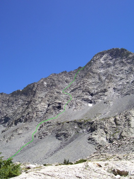
On Saturday, we got up bright and early and headed towards Little Bear. We hiked up the road to a cairn and made a right turn towards the talus slopes. As is described in the Colorado Scrambles book, we started by aiming to the right of the "black hand." At the bottom of the slope, the talus is fairly stable but it becomes progressively looser as you approach the "black hand." The larger talus was generally more stable.
Our route approximately followed the green line.
The initial climbing is class 4. We took care to stay on the more solid rock, although this meant we were pulling slightly harder, thinner moves. When our route got steeper, we headed left, carefully crossing over a talus slope. As can be seen in the photo, there are a few cairns, although they are not easy to find. We chose our own route, based on what looked to be the most solid and doable.
After the initial crux, traversing to the climber's left.
Higher up on the route, looking back down:
As can be seen in the above photos, there is alot of loose rock on the Northwest Face. Even though we were careful, we both dislodged some of it. We were surpised to find so much steep talus, as we had been expecting more of a scramble. We encountered another short class 4 section near the ridge (unfortunately I don't have a photo of the cool flowered lichen--it was pretty impressive). We had to tread carefully, as the rock was very loose but once we pulled a few harder moves, we attained a nice ramp that led to the ridgecrest.
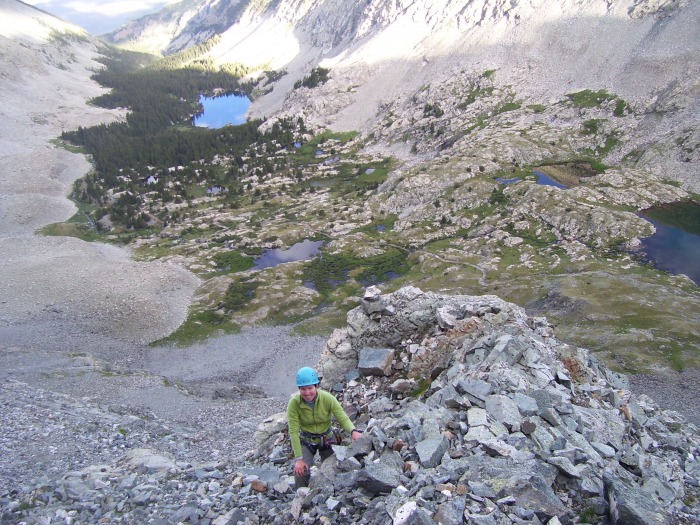
The lighting is not ideal in the first photo below, but it shows the uppermost part of our route (Ben is standing on the ridge looking down at me in the blue helmet).
I'm wearing the blue helmet. Ben is looking down on me from the ridge.
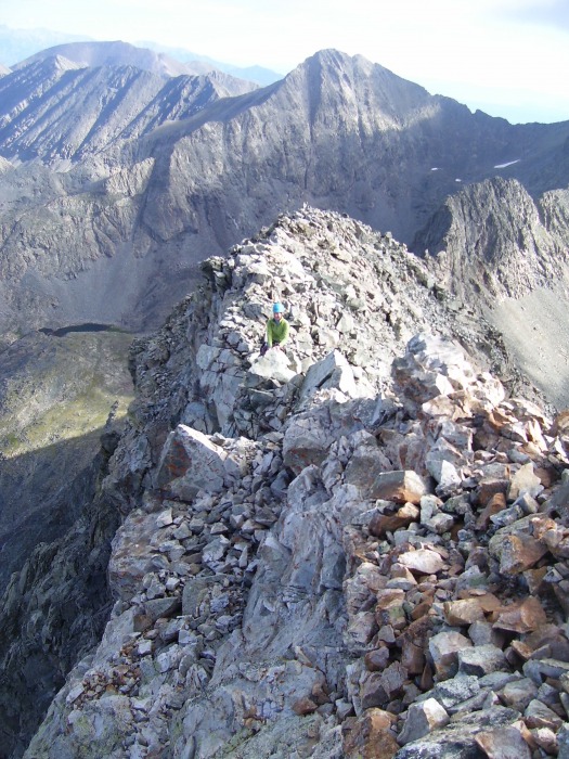
The traverse looks very impressive.
The ridge was looser than I anticipated (alot of blocks that were not attached), but the scrambling was fun to the summit.
We carried gear, although we didn't need it. Cams are great conversation starters.
I am always amazed by where you can find marmots.
We took the Hourglass down and found it to be very wet and slick (especially given that we hadn't seen rain since Thursday afternoon). The so-called "new" rope is a bit sketchy and looks like it was retired prior to being left in the Hourglass. Tread carefully.
We found a pile of the old ropes that had been cut down and left below the base of the Hourglass. It was too tangled to sort in a reasonable amount of time, so we cut the ropes into small, manageable pieces and butterflied them to make them easy to cart out. We took some out but there is still plenty of rope remaining--if each party took out a coil, it would soon be gone.
Thumbnails for uploaded photos (click to open slideshow):
The book was mildly useful - better than Roach's description - but there wasn't a lot of detail. Basically: start right of the black hand, move left into the gully when possible, head for the first notch north of LB. The book offers several GPS waypoints, but we didn't use them. I enjoyed the adventurous nature of the climb. Hope you have fun!
I would take the Northwest Face again, because I much preferred it to the Hourglass (while we were in the Hourglass, a large rock came careening down, narrowly missing us). Ben says he would take the Hourglass if it hadn't rained recently and wasn't on a weekend as it was a less committing route and much easier to follow than the NW Face.
Thanks for the report and response. We are planning to do Little Bear next week - midweek and have been considering the NW face route, but it sounds a little more loose than I imagined.
Nice idea. Everyone chip in and soon the rope will be gone!
Did you find the Colorado Scrambles book good info for the NW Face? I am interested in doing this route too in September.
Caution: The information contained in this report may not be accurate and should not be the only resource used in preparation for your climb. Failure to have the necessary experience, physical conditioning, supplies or equipment can result in injury or death. 14ers.com and the author(s) of this report provide no warranties, either express or implied, that the information provided is accurate or reliable. By using the information provided, you agree to indemnify and hold harmless 14ers.com and the report author(s) with respect to any claims and demands against them, including any attorney fees and expenses. Please read the 14ers.com Safety and Disclaimer pages for more information.
Please respect private property: 14ers.com supports the rights of private landowners to determine how and by whom their land will be used. In Colorado, it is your responsibility to determine if land is private and to obtain the appropriate permission before entering the property.


 Our route approximately followed the green line.")
 After the initial crux, traversing to the climber's left.")
")
 The traverse looks very impressive.")
")
 We carried gear, although we didn't need it. Cams are great conversation starters.")
 I'm wearing the blue helmet. Ben is looking down on me from the ridge.")
")
 Looking at the route up Ellingwood.")
")
 Looking at Blanca from Ellingwood--can it really be 9 am?")
 Looking back at Ellingwood.")


