Download Agreement, Release, and Acknowledgement of Risk:
You (the person requesting this file download) fully understand mountain climbing ("Activity") involves risks and dangers of serious bodily injury, including permanent disability, paralysis, and death ("Risks") and you fully accept and assume all such risks and all responsibility for losses, costs, and damages you incur as a result of your participation in this Activity.
You acknowledge that information in the file you have chosen to download may not be accurate and may contain errors. You agree to assume all risks when using this information and agree to release and discharge 14ers.com, 14ers Inc. and the author(s) of such information (collectively, the "Released Parties").
You hereby discharge the Released Parties from all damages, actions, claims and liabilities of any nature, specifically including, but not limited to, damages, actions, claims and liabilities arising from or related to the negligence of the Released Parties. You further agree to indemnify, hold harmless and defend 14ers.com, 14ers Inc. and each of the other Released Parties from and against any loss, damage, liability and expense, including costs and attorney fees, incurred by 14ers.com, 14ers Inc. or any of the other Released Parties as a result of you using information provided on the 14ers.com or 14ers Inc. websites.
You have read this agreement, fully understand its terms and intend it to be a complete and unconditional release of all liability to the greatest extent allowed by law and agree that if any portion of this agreement is held to be invalid the balance, notwithstanding, shall continue in full force and effect.
By clicking "OK" you agree to these terms. If you DO NOT agree, click "Cancel"...
My alarm went off at 12:45 a.m. I thought long and hard about just going back to sleep, but I eventually rolled out of bed, dressed, had a peach and a small glass of milk for my first breakfast of the day, and then loaded up my car and drove toward the mountains at 1:15 a.m. It was a pleasant drive, especially after I turned onto Highway 7 in Lyons. The nearly-full moon illuminated the mountain ridges in front of me, and the curvy road kept me awake and attentive. I parked at the trailhead (lot was filling up, but still plenty of spots available), put on my backpack and recently-purchased Black Diamond headlamp (bought specifically for my Longs Peak night-op!), and was signing the registry at exactly 3 a.m.
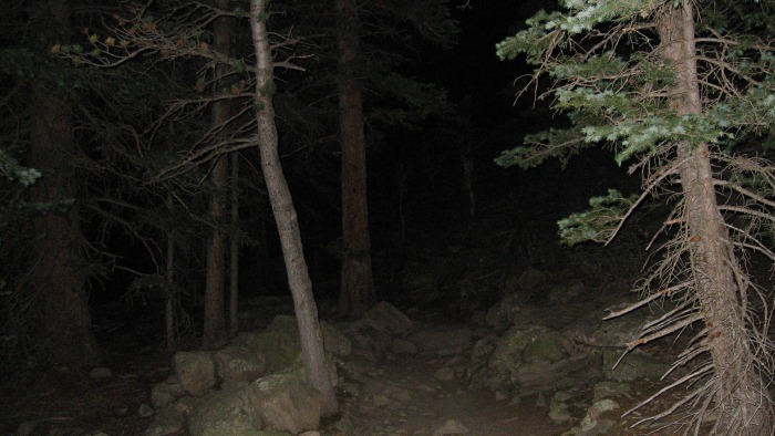
I stopped to take off the fleece that I was wearing after about 10 minutes of hiking. The temperature was only 57 degrees, but I was already starting to sweat a little. I passed a couple large groups of hikers at the Goblins' Forest campsite, but for most of the rest of the hike until the Keyhole I was almost completely alone. Walking through the firs and pines alone at night certainly did evoke a Goblins' Forest; I expected a band of orcs to ambush me at any minute--or at least a mountain lion.
Near the Goblins' Forest campsite"about 3:30 a.m.
When I crossed the primitive bridge spanning the cascades of Alpine Brook, the burbling of the water and the perfume of the pines made me realize that I no longer cared anymore if I made it to the summit of Longs Peak. I was perfectly content just to spend some time in the cathedral that is Rocky Mountain National Park. I slowed down a bit after that moment, trying to savor each step. By 4:00 a.m. I was above treeline, and to the southeast I could see the lights of Boulder and Denver glimmering. Despite the blight that the glare was on the natural darkness of night, I couldn't help but marvel at humanity's industriousness and innovation.
By 4:30 a.m. I made it to the "Y" where the Chasm Lake Trail splits off to the left from the East Longs Peak Trail, which continues to the right. Almost exactly at this point, I was confronted by a fierce, frigid west wind coming over the mountains, and I instantly became cold. I could also begin to clearly discern the shape of the two behemoths in front of me: Mt. Meeker and Longs Peak. I was already at an elevation of 11,500 ft., but they still towered above me. I put my fleece back on and continued on the East Longs Peak Trail. The first warm glow of the arriving sun could be seen to the east by 4:45 a.m., but it didn't do much to warm me up. By 5:00 a.m. I could take off my headlamp, which had worked like a charm throughout the morning. At 5:15 I was at an elevation of about 12,250 ft. The sun had not quite yet appeared over the horizon, but I was hungry and needed a break. I ate two hard-boiled eggs (my favorite 14er breakfast) and also had a couple of bites out of one of the two peanut butter and marmalade sandwiches I had brought. The temperature had dropped to 44 degrees, and my ears and hands were cold. I pulled out my winter hat and gloves before continuing onward.
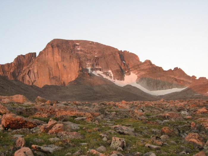
At 5:45 a.m. the first sliver of sun appeared on the horizon, and a few minutes later I had made it onto the Boulderfield. My trekking poles at that point became more of a nuisance and liability than anything else, as they started to become caught between the craggy rocks and boulders of the trail. I stowed my trekking poles in my pack and continued. Looking ahead, I caught my first view of the Keyhole to the southwest. This really got my heart pumping! I had read so much about the Keyhole that it had taken on a mythical significance to me. It was the portal to another world, another dimension even. It was the gate through which those who dared to conquer Longs Peak had to pass (well, at least those climbing the Keyhole route!). It was invigorating to finally see it with my own eyes.
Alpenglow on the north face of Longs Peak. The Keyhole is on the far right.
I went pretty quickly through the Boulderfield, stopping only for a brief pit-stop at the solar privy near the Boulderfield campsite. I was nearly to the beginning of the scramble up to the Keyhole by 6:30 a.m., so I stopped for a short break and to have a few more bites from my sandwich. At this point I started to meet several other people, some alone and some in large groups. As much as I enjoy the solitude of an empty trail, it is always a pleasure to chat with fellow climbers. I eventually scrambled up to the Keyhole, where even more people where congregating (most having a breakfast snack before crossing through). I was at the threshold to the Keyhole just before 7 a.m. The winds were fierce, and I considered turning back. A climber from Rhode Island had died the week before on Longs Peak, apparently due to high winds. But a veteran climber reassured me that the winds died down considerably past the "wind tunnel" of the Keyhole. I took a deep breath, got a solid handhold, and thrust myself through the Keyhole.
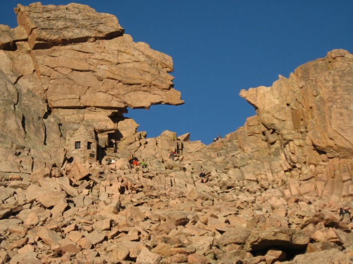
The Keyhole
The veteran climber had been right. After only about 25 yards, the wind died down. I had been concerned about the exposure on this west-ridge traverse on Longs, but I honestly didn't think it was bad at all--and I usually get frightened by even the slightest bit of exposure. I had climbed the Sawtooth route between Bierstadt and Evans a few weeks before this climb, and, compared to the Sawtooth, this was yawnable. By 7:30 a.m. I was at the base of the Trough, a wide gulley that naturally funnels climbers upward. I stopped for a few minutes to pull out my map and reflect upon the topography to the west; McHenrys Peak was especially stunning.
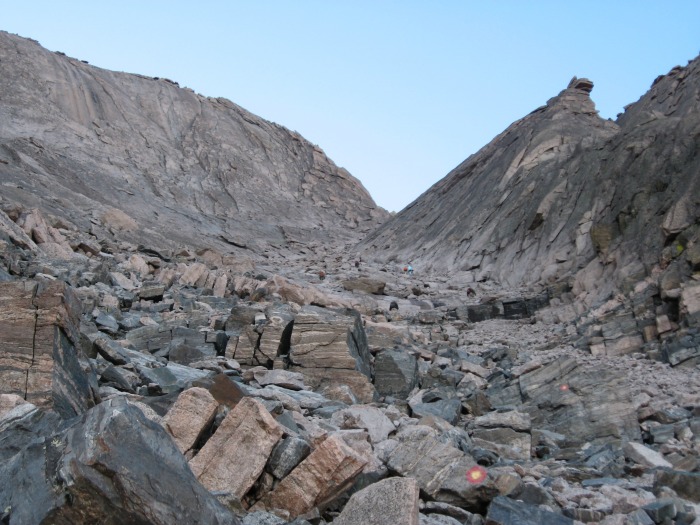
At the bottom of the Trough"still a long way to go!
McHenrys Peak from the east.
It only took me around 45 minutes to scramble to the top of the Trough, but it seemed like a lot longer than that. I felt like I was scrambling forever and never getting any closer to the top. I took a couple of short breaks on the way up to let faster climbers pass, but I still made fairly good time. By 8:15 a.m. I was at the Chockstone, an imposing boulder blocking an easy scramble to the top of the Trough. There were two climbers at the Chockstone helping a third climber with a broken arm down. They were pretty busy trying to determine their best strategy, so I never did find out how the third climber broke his arm. I did pause to consider what a nightmare it would be to try to descend the Trough with one less appendage.
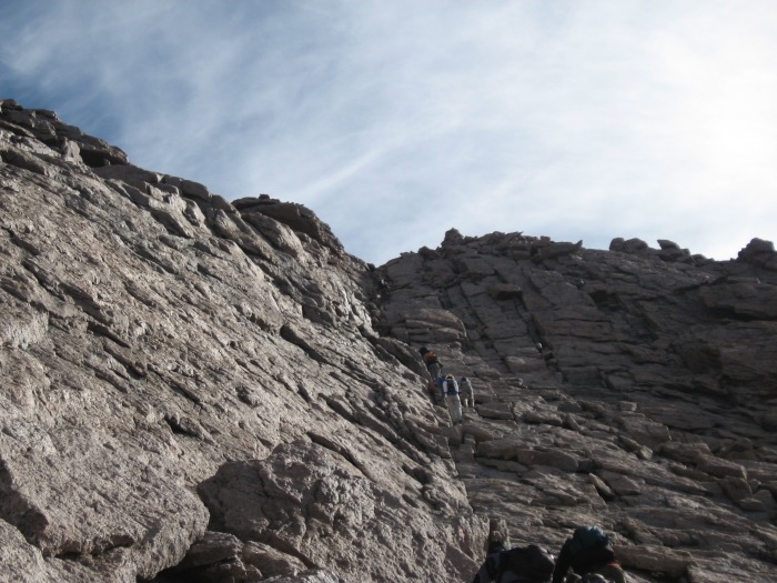
Apparently you can go around the Chockstone to either the left or the right. I examined both, and the right side looked much better to me. Up and over, and the wind was once again fierce. This was the start of the infamous Narrows, of whose expanses of exposure I had read so much about. I asked a descending climber if it was safe, and he said it was no problem: "just take your time and get good handholds." I was worried about the Narrows given my fear of exposure, but I forged ahead. I was pleasantly surprised to find that the reputation of the Narrows was vastly overrated. There were only a couple of spots where I thought to myself, "Yeah, this looks a tad frightening." Nothing like the Sawtooth, where there were at least half a dozen times that I thought, "Holy Jesus, I'm going to die up here!" The only real annoyances were a couple of tight spots that I had to squeeze through, backpack and head scraping across the rock. By 8:30 a.m. I was looking up at the Homestretch. As everyone says, it isn't nearly as steep as it looks in the photos. But it's still steep, probably approaching 45 degrees. It reminded me a lot of the Trough, only steeper and with fewer good handholds. Again, it seemed like I was climbing up the Homestretch forever without making much progress.
The Narrows. Exposure seemed fairly minimal, despite its reputation. Notice the "bulls-eye" near the top climber&
The Homestretch. Not as steep as it looks, but still steep!
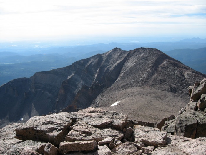
At 9:00 a.m. I climbed onto the summit. Woohoo! I walked completely around snapping photos and finding landmarks with the help of my topo map. The views of Mt. Meeker and Chasm Lake were especially beautiful, but I also enjoyed looking northward across the Boulderfield to Flattop Mountain, Bear Lake, and Tombstone Ridge. Even better, the weather was perfect with no threat of thunderstorms to the west, so no need to rush down on my descent. It was thrilling to be able to look down at all of the other hikes I had done and still want to do in Rocky Mountain National Park. No matter what elevation you're at within it, RMNP is one of the most beautiful places on Earth.
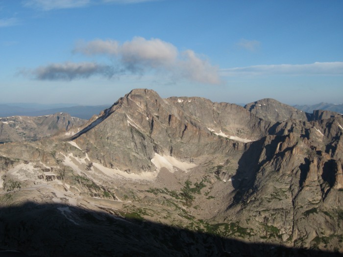
Mt. Meeker and the Loft
I spent only about a half-hour on top and started my descent at 9:30 a.m. I always hate going down--more dangerous, plus the adrenaline rush of getting to the summit is over. On the way down the Homestretch, I stopped to chat with two guys who had climbed up the Loft route. I'd really like to try that route in the future, so I was curious about their experience. They said it was pretty exhausting and had significant exposure, quite a bit more difficult than the Keyhole route. This had contradicted a few trail reports that I had read about the Loft route, so I pressed them a bit more and asked how difficult it was to find "Clark's Arrow," a painted sign which marks the easiest path up. "I think Clark's Arrow is a damned myth!", one of them said. "We looked forever for the blasted thing and never did find it!" I got a good chuckle out of this--it's probably what would happen to me if I tried the Loft route. This probably explains why they found the Loft route so difficult, but I imagine it would be easy enough to get off trail on this less-often used route up Longs Peak.
My descent was fairly uneventful, just seemed like it took forever to go down the Homestrech and the Trough. I took a few breaks here and there to eat some of my sandwich and look at my topo map. I am amazed at the varying speeds of climbers. At the bottom of the Trough I passed a couple still climbing up who had left the trailhead a full hour before me. But another climber who had left the trailhead two hours after I did passed me on his way down!
I was back through the Keyhole at 11:30 a.m. and stopped to put on some sunscreen. I could finally stow my winter hat and fleece and switch back to baseball cap and long-sleeved shirt. I chatted briefly there with a woman from Illinois who was patiently waiting for her husband. I hope she didn't have to wait much longer--she seemed to be getting frustrated.
I started to get tired crossing back across the Boulderfield. Not to sound like an old man, but I really started to feel the effects on my knees of hopping from boulder to boulder. I was awfully glad to be out of the Boulderfield at 12:30 p.m. I could finally get my trekking poles back out, although, to be honest, I don't think they helped much on this trek (more on this later). A while later I could feel some blisters forming on the bottom of my big toes. I stopped and put some duct tape around them--a tip I'd picked up at an REI workshop on hiking. It really worked like a charm, and I'm going to make sure I always have a roll of duct tape with me on long hikes from now on.
The aptly-named Boulderfield.
At 1:20 p.m. I was back at the "Y" with the Chasm Lake Trail. A couple of llamas or alpacas (I don't know how to tell the difference) were tied up at the hitching post. Cute little guys, anyway. I decided to add a few miles to my hike and see Chasm Lake. Looking back on it, this was probably a bad idea. I was already tired, and the trek up to Chasm Lake was harder than I expected and required some more scrambling. Columbine Falls were certainly worth it, however, and the view from Chasm Lake upward toward the east face of Longs Peak was splendid. It was also awfully refreshing to dip my head into the lake's frigid waters.
East face of Longs Peak from Chasm Lake.
Made it back to the "Y" at 3:00 p.m. It took me much longer than I thought to do the 1.5 mile detour to Chasm Lake. I was pretty exhausted by now, but thankfully it was all downhill from there. Back to treeline at 3:30 and was marking my return on the trailhead registry at 4:30 p.m.
This was a grand but physically-exhausting day. When I attempt Longs Peak again (and I certainly plan to do so!), I definitely think I'll camp at the Boulderfield campsite instead of doing the whole thing in one day. Hiking about 16 miles in one day (almost 18 if you include the Chasm Lake detour), a good portion of which is Class 3 scrambling, takes some of the fun out of this trek (especially on the descent). The physical effort involved is considerable, so the Keyhole route should definitely not be taken lightly. Indeed, I passed several poor hikers who, having only reached the Keyhole, were so exhausted already that they could not continue. In my opinion, camping at the Boulderfield would make the hike much more enjoyable.
I would also recommend that you leave the trekking poles at home. For Class 1 and Class 2 14ers, trekking poles are worth their weight in gold. But there was too much Class 2+ and Class 3 on the Keyhole route to make them worth carrying. They were also a nuisance on the Narrows, since, sticking out of my backpack, they hung me up a few times while going through some tight squeezes.
Climbers with fear of exposure should rest assured, however, that the exposure on this route is fairly minimal. As long as the route is dry and free of snow, I don't think you'll have any major pangs of fear, even in the Narrows. I HATE exposure, and there was never a single instant on this climb that I had an "Oh my God!" moment.
In conclusion, it's a long way to the top, and you'll be tired by the time you get back to the trailhead. But it's Longs-fricking-Peak! You gotta climb it at least once in your life!
Thumbnails for uploaded photos (click to open slideshow):
Your pic on the narrows is the best one I've seen that shows a good view of its width. I was concerned about that and the OMG moment. Longs is on my list for this year. Hopefully, it will happen. Also, I think staying at the Boulder Field is a good idea to help spread the exursion a little. Thanks for confirming that, as well. I use my poles alot. Not sure I can give them up! But, what you said makes alot of sense. Thanks for a very informative report and pics.
ChrisM
The details in your writeup are really interesting, thanks for sharing them. Longs was my first peak. I think it would stay my ”favorite” forever if not for that death march back. I have to disagree about the trekking poles, however. I would still be up there if I didn't have them on the way back. Well, I suppose someone would have hauled my body down. I'd say stash 'em at Boulder Field. We left our poles, some gear, water and food in marmot-proof containers there. We didn't know marmots like to eat the handles but we got lucky and our survived. Seems like you could pile some heavy rocks on them to protect them.
... and congratulations on summitting.
Many of your initial questions and concerns about your ability to succeed on this route are mine, as well. You did a great job of translating your experience and addressing those questions via text and photo. Thanks a bunch!
I have been searching for a picture of the narrows that portrays its width and scale with that of people on it. Your picture helps answer my questions about this portion of the hike. Thanks. Perhaps it really is doable.
Thanks for the trip report. I'm headed up Long's Peak on Thursday...my first attempt. Hopefully the weather will hold out. I'm assuming you did NOT wear a helmet. Is that right? Thanks for the advice on not taking the poles, too. I think they are often a hindrance so I won't be taking mine now, thanks to your report.
Thanks for the friendly comments, gang. DeTour, nice tip about stashing trekking poles at the Boulderfield--that would work nicely. MOTownFrau, I didn't wear a helmet and don't think it's absolutely necessary for the Keyhole Route if the weather is good. That being said, if it makes you feel safer, go ahead and wear it. You never know when someome is going to accidentally kick a boulder down onto your path. I usually reserve the helmet for Class 4 routes, but that would be a great 14ers.com forum subject. HAPPY CLIMBING!
Wow you really took me throught the journey! I'm planning my first attempt at Longs end of August it was great you put in those little details that we hiker/climbers look for! Thank you!!
Caution: The information contained in this report may not be accurate and should not be the only resource used in preparation for your climb. Failure to have the necessary experience, physical conditioning, supplies or equipment can result in injury or death. 14ers.com and the author(s) of this report provide no warranties, either express or implied, that the information provided is accurate or reliable. By using the information provided, you agree to indemnify and hold harmless 14ers.com and the report author(s) with respect to any claims and demands against them, including any attorney fees and expenses. Please read the 14ers.com Safety and Disclaimer pages for more information.
Please respect private property: 14ers.com supports the rights of private landowners to determine how and by whom their land will be used. In Colorado, it is your responsibility to determine if land is private and to obtain the appropriate permission before entering the property.


 Near the Goblins' Forest campsite")
 Alpenglow on the north face of Longs Peak. The Keyhole is on the far right.")
 The Keyhole")
 At the bottom of the Trough")
 McHenrys Peak from the east.")
 The Narrows. Exposure seemed fairly minimal, despite its reputation. Notice the")
 The Homestretch. Not as steep as it looks, but still steep!")
 Mt. Meeker and the Loft")
 The aptly-named Boulderfield.")
 East face of Longs Peak from Chasm Lake.")