Download Agreement, Release, and Acknowledgement of Risk:
You (the person requesting this file download) fully understand mountain climbing ("Activity") involves risks and dangers of serious bodily injury, including permanent disability, paralysis, and death ("Risks") and you fully accept and assume all such risks and all responsibility for losses, costs, and damages you incur as a result of your participation in this Activity.
You acknowledge that information in the file you have chosen to download may not be accurate and may contain errors. You agree to assume all risks when using this information and agree to release and discharge 14ers.com, 14ers Inc. and the author(s) of such information (collectively, the "Released Parties").
You hereby discharge the Released Parties from all damages, actions, claims and liabilities of any nature, specifically including, but not limited to, damages, actions, claims and liabilities arising from or related to the negligence of the Released Parties. You further agree to indemnify, hold harmless and defend 14ers.com, 14ers Inc. and each of the other Released Parties from and against any loss, damage, liability and expense, including costs and attorney fees, incurred by 14ers.com, 14ers Inc. or any of the other Released Parties as a result of you using information provided on the 14ers.com or 14ers Inc. websites.
You have read this agreement, fully understand its terms and intend it to be a complete and unconditional release of all liability to the greatest extent allowed by law and agree that if any portion of this agreement is held to be invalid the balance, notwithstanding, shall continue in full force and effect.
By clicking "OK" you agree to these terms. If you DO NOT agree, click "Cancel"...
Pacific Peak East Ridge
Friday July 16th 2010
7 Miles RT 3300 vert feet
Participants: Slopestyle, emiller
Residing in northern Illinois doesn't provide a lot of opportunities to get into the mountains. So I was very thankful the wife let me get away for the day to indulge. Thursday night the forcast for summit county showed a 0% chance of percipitation. I was really amped looking forward to the climb and good weather. The usual early morining alarm but with a twist, Slopestyle called to say he would be delayed about 45 min. Perfect for me as a flatlander i'm quite a bit slower.
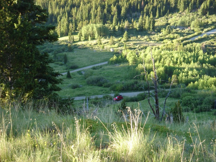
The road to the trailhead is in quite good shape and a 4wd probably isn't necessary to reach it. Boots hit the ground at about 6:30. There is no warm up for this route as you gain elevation quickly up a steep grassy slope right out of the car.Looking Back at the start When you reach the top of this slope the terrain opens into a slightly wooded alpine bowl with a ring of snow around the top. It appears as though there is some major willow bashing ahead. However i stayed to the left side(west) and was not held up to bad. First alpinebowl It only really required about 20 yards of real willow bashing to get through. beyond the willows I stayed on the shorter mellower east side of the headwall to gain the ridge proper.
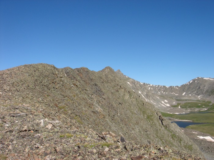
Just as i crested the ridge I looked back on where I had been and saw Slopestyle gaining ground quickly. A quick phone call down to him and he saw me as well. I continued my slow but steady pace up the ridgeline. When you first gain the ridge it is very mellow tundra hiking. I looked over to the north and saw a large bull elk and a couple of his lady freinds make a quick decent down towards mowhawk lake. after another quater mile or so the ridge changes from tundra to rock.start of the ridge, Pacific in distance I waited here for a few minutes and Slopestyle arrived.
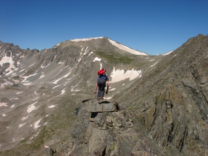
Initially the ridge is pretty gentle but you can see towers looming in the distance and Pacific beyond. The difficulty increases gradually, but just when you think its going to be a little dissapointing things really get going. To keep things as interesting as possible we stuck to the ridge at all times. It looked like you could traverse 50 or so feet below the ridge top at most times if things got to spicy for your liking. For the next mile or so the rock was very solid and the scrambling was a blast.Slopestyle leading the way The ridge top was very exposed at times to the north. Every couple hundred yards you had to decend of of a tower to a gulley that would rise up the north or south side of the ridge. small catwalk on ridge top The down climbing was solid and required focus but still class 3.
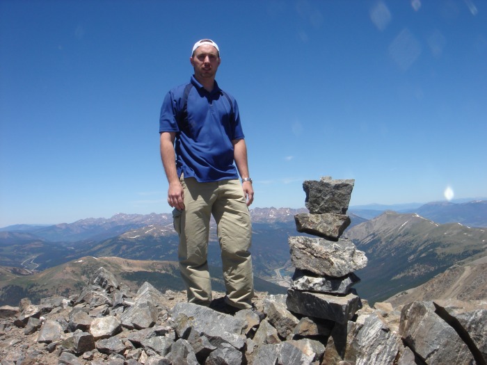
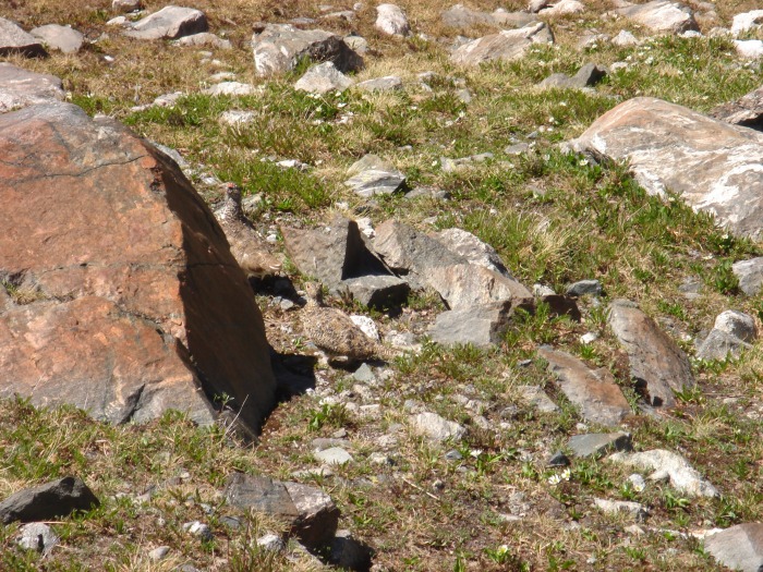
Just when you think you are at the plateau below the summit you realize you are on top of the last and steepest downclimb.decent to plateu beneath pacific This was the one time we had to leave the ridge crest and the rock becomes slightly rotten. The route changes to a talus slog across the plateau. Then you arrive at the base of pacific's summit pyramid. The alltitude was really getting to me at this point and my progress became really slow. Huffing and puffing I finally joined Slopestyle on the summit.Success! The view to the north off the north face of Pacific is impressive to say the least. Looking towards Atlantic you can see a faint climbers trail decending the connecting ridge. After resting for about 10 min we started the decent. The going was easy until we reached the Pacific and Atlantic sadle. In retrospect there is a faint trail here but I believe it was covered in snow and we missed it. It became a very tedious talus slog ptarmigan in upper McCullough gulch and decent until we finally found it again about 1.5 miles later. Stay to the right when coming off the saddle and you should find the trail. At this point in time 10 yards of willows seperated us from the trail. Upon regaining the trail we encounteredthe first peoplle we had seen all day except for the climbers skylined on Quandary's east ridge early in the morning. The trail left another 3 miles plus to the trucks. I had jammed my toe really good slipping on some talus during the decent and had 2 blisters. Consequently was moving really slow. Slopestyle had to get going and jetted on down the trail. eventually the trail became flatter and i was able to pick up the pace. The final three quater miles on the road seemed to go on forever. Then suddenly Slopestyle appeared in his truck and gave me a ride the rest of the way to my truck. 10hrs on the go and I was exhausted. I returned to Frisco to an angry wife who expected me 3 hrs earlier .
The following monday when back home in Illinois I went to visit the doctor and he drilled a hole in my left big toe nail to relieve the swelling.
Overall this was a great climb with solid scrambling, great views and little traffic. Definetly a classic.
Thumbnails for uploaded photos (click to open slideshow):
I would think 6-7 hrs would be a reasonable time if your not a flatlander. The altitude really got to me the last 400 feet up pacific. Also if you have a partner I would park a 2nd car at the main McCullough gulch trailhead to save the road hike at the end
Pacific's on my summer list, anyway, and your pics and TR just pushed it up several notches. That looks like a lot of fun, detours and extra time aside. Thanks.
I think I will give this a shot this weekend. Thanks for the info!
Caution: The information contained in this report may not be accurate and should not be the only resource used in preparation for your climb. Failure to have the necessary experience, physical conditioning, supplies or equipment can result in injury or death. 14ers.com and the author(s) of this report provide no warranties, either express or implied, that the information provided is accurate or reliable. By using the information provided, you agree to indemnify and hold harmless 14ers.com and the report author(s) with respect to any claims and demands against them, including any attorney fees and expenses. Please read the 14ers.com Safety and Disclaimer pages for more information.
Please respect private property: 14ers.com supports the rights of private landowners to determine how and by whom their land will be used. In Colorado, it is your responsibility to determine if land is private and to obtain the appropriate permission before entering the property.