Download Agreement, Release, and Acknowledgement of Risk:
You (the person requesting this file download) fully understand mountain climbing ("Activity") involves risks and dangers of serious bodily injury, including permanent disability, paralysis, and death ("Risks") and you fully accept and assume all such risks and all responsibility for losses, costs, and damages you incur as a result of your participation in this Activity.
You acknowledge that information in the file you have chosen to download may not be accurate and may contain errors. You agree to assume all risks when using this information and agree to release and discharge 14ers.com, 14ers Inc. and the author(s) of such information (collectively, the "Released Parties").
You hereby discharge the Released Parties from all damages, actions, claims and liabilities of any nature, specifically including, but not limited to, damages, actions, claims and liabilities arising from or related to the negligence of the Released Parties. You further agree to indemnify, hold harmless and defend 14ers.com, 14ers Inc. and each of the other Released Parties from and against any loss, damage, liability and expense, including costs and attorney fees, incurred by 14ers.com, 14ers Inc. or any of the other Released Parties as a result of you using information provided on the 14ers.com or 14ers Inc. websites.
You have read this agreement, fully understand its terms and intend it to be a complete and unconditional release of all liability to the greatest extent allowed by law and agree that if any portion of this agreement is held to be invalid the balance, notwithstanding, shall continue in full force and effect.
By clicking "OK" you agree to these terms. If you DO NOT agree, click "Cancel"...
I knew I was going to be a bit tired going into this trip. I worked the graveyard shift midnight to 8:00 am, drove home for a quick shower and some last minute items, and then drove about 4 hours to the trailhead.
I had previously reserved a campsite up at the boulderfield for that night. The website says to check in by 8:00am, but I called a few days ahead of time and told them about my work schedule , they said that was fine and they made a note on my account that I would be up later. If they know you are running late, or can't get there by 8:00 am, Be sure to call them and let them know so that they don't give your camp site reservation away!
I arrived at the trailhead about 1:00 pm. It was raining. I went inside and registered, got my permit tag. The rain caused many of the tourists to clammer into their cars and drive away. I moved my car to one of the many, now open, parking spots closest to the trailhead. Nice. Rain is not always a bad thing. All my gear was still in a big plastic tub that I had thrown in the car the night before. By the time I finished packing my gear, food and water into my pack, the weather had cleared up.
I hit the trail at 2:15 pm. I've listed my times so that if anyone in reading my other trip reports and had a similar time there, then they will know what to expect when they take on this mountain.
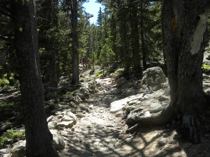
It starts out as a nice, smooth trail that slopes upward gently. Soon it gains steps built from rounded wood beams as the trail increases in gradient. These wood steps later give way to stone steps and soon it's a rocky trail with on again/off again stone step.
The first 2+ miles is in the trees with dappled sunlight. Long switch backs as you gain elevation.
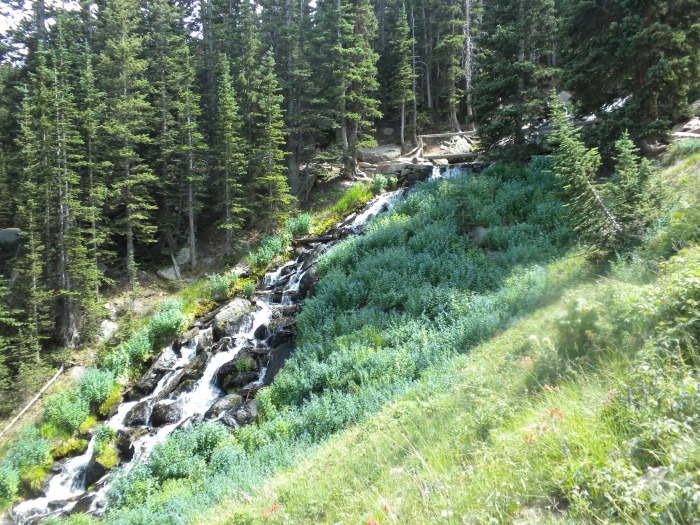
The largest creek crossing is pretty. You can see the bridge at the top of the pic.
Eventually the trees become shorter and shorter as you near treeline and soon all you are left with for vegitation is grasses, a few wild flowers, some willow bushes and Engelmann pine clumps that are no more than 6-12 inches high as they spread out like ground cover.
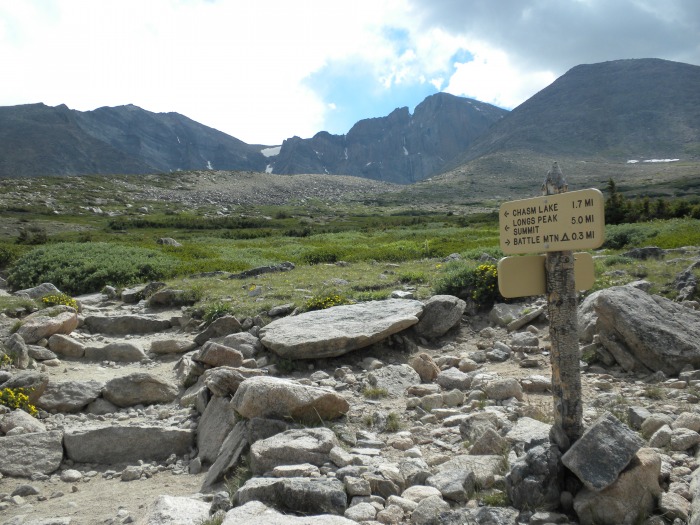
Longs Peak begins to rise above the horizon as you leave the trees behind. Here's the milage/direction sign at a trail junction. You next destination is the Chasm Lake trail junction. Is is located on the low part of the rocky hill ahead, directly below the notch on top of the mountain.
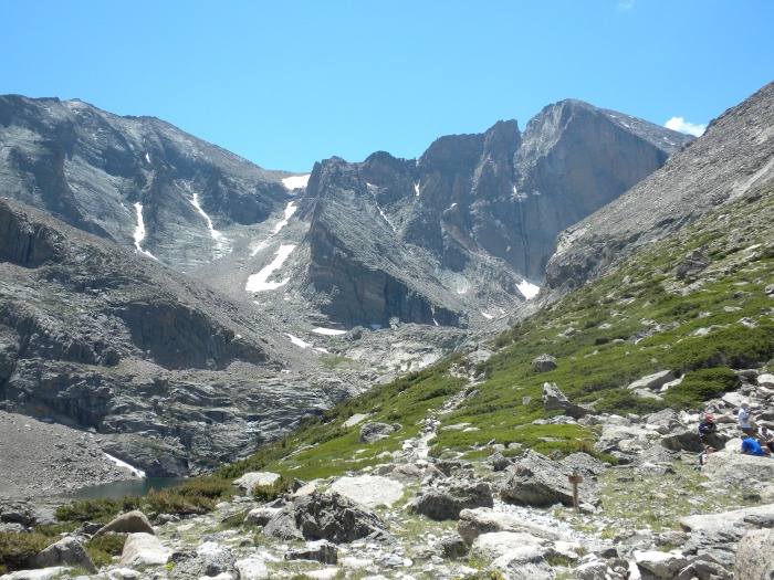
View of Longs Peak from the Chasm Lake trail junction. The trail to Chasm Lake straight ahead and Peacock Pool can be seen to the lower-left in the pic. Chasm Lake is up the canyon and around the corner. The Loft route is up the large gully right of center. There is also a privy back behind me as I'm taking the picture. The trail toward the boulderfield and keyhole is to the right of the pic.
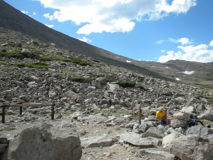
From the Chasm Lake trailhead, my next destination is Granite Pass. It's that low spot on the horizon in the next pic; directly above the guy wearing the yellow shirt.
At the top of Granite Pass you come to another trail junction. The trail toward the boulderfield leads up the slope behind the sign as seen in the next pic. Several long switch backs as you climb with multiple signs saying that shortcutting is prohibited.
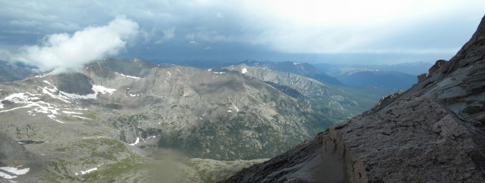
At the top, the boulderfield finally reveals it'self, along with Longs Peak and the keyhole far ahead.
There were several pika running around the trail along here. The little guys are about the size of a baseball. I had left my baseball bat at home, so I just took a picture. ;)
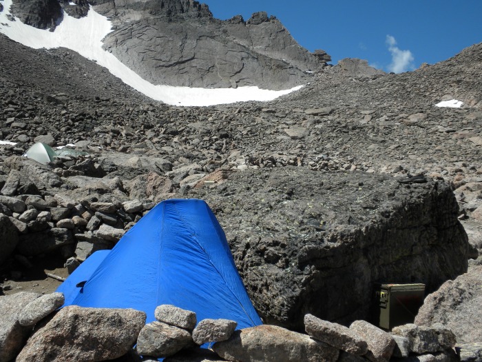
My tent site. (photo taken the next day). I had a nice view of the keyhole and the peak from here. I arrived around 6:00 pm. Not too quick due to only sleeping 6-10pm the night before and working the graveyard shift and stopping to take a lot of pictures. I still had more than enough time to set up my tent, cook food, filter some water and prep my summit pack, all before it got dark about 9:00 pm. After a little star gazing, I was in bed by 10:00 pm
The next morning I got out of my tent at 6:00 am. The morning alpenglow was still on the peak and keyhole. 5 more minutes and I would have missed that. I slept like a log. The secret is a REAL pillow. I brought up the down pillow I sleep on at home. I Flattened it out, folded it in half, rolled it up and wrapped it with a strap. It doesn't take up much space in the pack and is SO WORTH IT!
Zoomed view of the keyhole and rock shelter.
Blue skies at 6:00 am, not a visible cloud to be seen..... until about 6:20 am as some appear behind the keyhole. Damn. I better get moving. Eat one of the two giant Fuji apples I brought, toss the rest of my breakfast and lunch in the pack, tidy up camp, and I'm on my way at 6:45 am.
I arrive at the keyhole about 20 minutes later. The wind is rushing into my face from the keyhole.
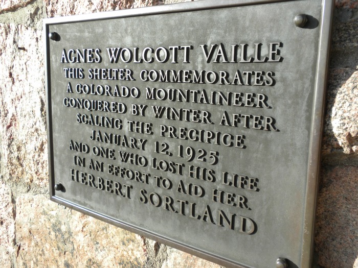
Here's a shot of the plaque mounted on the rock shelter. There is no door to the shelter and there is a decent size snow drift taking up about 1/2 the floor space slowly melting away. I would have thought that some hiker would have scooped it out by now. I didn't feel like burning precious daylight doing it before the summit, so I moved on. On my way back, I was too tired to worry about it, so now I know way the snow is still there.
View on the other side of the keyhole. So much for a nice blue sky day. Now I'm wishing I had gotten out of the tent an hour earlier. I started back on the route just after 7:00 am.
From here the rest of the trail is off to the left, out of the picture. It's left along the ledges as the trail starts to round the mountain; up, up the trough; go around a corner and then continue left along the narrows. You 'round the next corner and then up the homestretch to the summit.
The Ledges section ahead. The trail lead you along a lot of up and down as you traverse. It's starting to sprinkle a bit. Damn, I'm hungry. One apple doesn't last long. Time to eat 1/3 of my turkey sandwich.
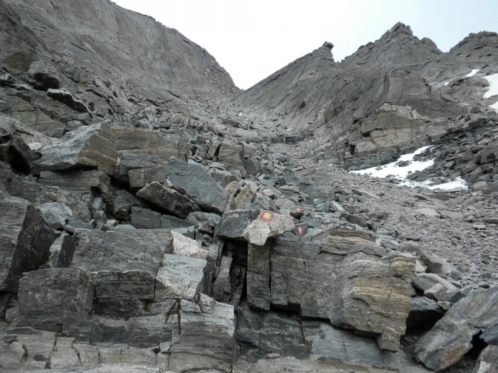
Looking up the trough. It curves to the right about 2/3 the way up. Snow is not a factor at all. The tiny scraps that remain are well off to the right side as you climb. There is very little water on the trail from their melt. Water from rain? yeah, there is a little of that, mixed with some sleet now.
looking up the top 1/3 of trough at the curve.
You can't exit the trough until you negatiate the choke rock at the top. I chose to ascend it on the right-side, but came down on the left-side. Pick your poison.
There is a benchmark at the top of the trough before you begin the narrows. Nice break site with a view of the wet weather. I'm hungry again. Time for another 1/3 of my sandwich. I have to force it down. It tastes great, but the stress from the weather and altitude is making me a tad nauseous.
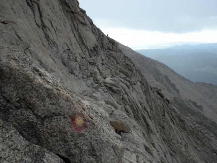
Looking forward to the narrows. This section is similar to the 1st part of the ledges, but, um, more narrow, hence the name. It's total length is shorter that the ledges section. Still sprinkling and there are small puddles here and there on the trail. You can see a trail marker "bulls eye" in this picture. They are easy to follow both directions. You may notice them sporadically in the pictures.
Narrows complete, now looking up the homestretch. I'm starting to get some real rain now.
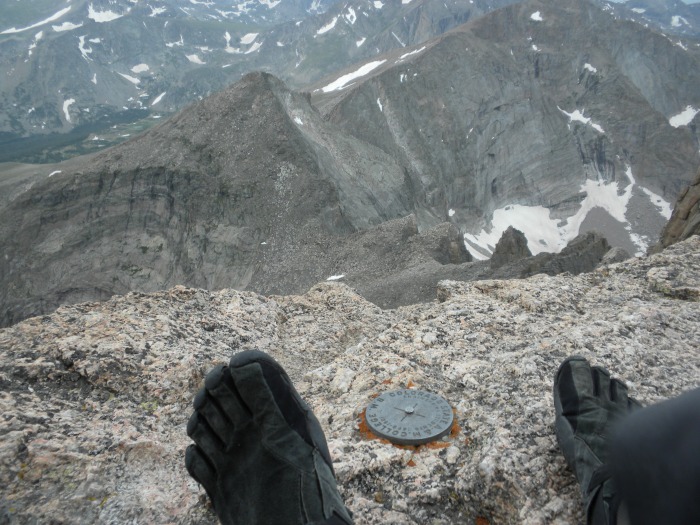
On the summit! My Vibram Five Finger, (VFF), KSO trek shoes were great in getting me all the way here from the trailhead. Now they got to get me back, in the rain on wet rock. I arrived at the summit at 8:30 am.
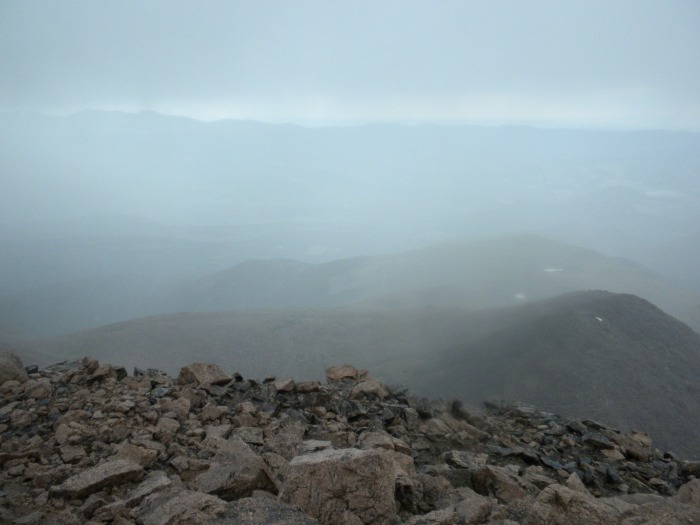
View from the summit rock toward the boulderfield. Rain.
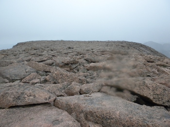
View of the broad, flat summiit. Rain.
View back down the homestretch. That pile of rocks on the bottom-right corner of the photo is the summit cairn. This is the easiest way up and down the mountain. Today it is wet, so not so easy. More rain.
It's raining on me all the way down the homestretch with a little bit of hail mixed in for good measure. Across the narrows it's still raining, then begins to taper off as I descend the trough. By the time I reach the bottom of the trough it has mostly stopped. I only had one foot slip on me, but I had both hands gripping rock, so it was a non-event.
That's the beauty of VFFs. Their thin soles let your foot curve around the rocks and you get lots of traction with the KSO treks, even when it's wet if you take your time.
The sun starts to brighten the view across the way while I'm working my way along the ledges. You can see the keyhole way ahead occasionally, but there is alot of up and down to get to it.
Finally, the keyhole appears about 100 feet away, and at the same elevation as me! 9:55 am.
Looking back though the keyhole, down and across the boulderfield. I realize that I'm hungry again. Time to eat that last 1/3 of my sandwich. I had been hitting GU and cliff blocks the whole time, but real food is so much better.
View back down the boulderfield from my campsite. You would never know that about 1 hour ago I was rained on, sleeted on, rained on, hailed on, rained on, and fighting high gusts of wind much of the time.
The two structures on the left side are the privies. You can see the hitching post on the right of the picture. Beyond the hitching post is the stream for filtering your water. It's about 6 feet below you under the rocks. With a little time, you can climb down between gaps, and dangle you filter hose down to the flowing water.
I rested about an hour while my shoes, clothes and rain gear dried in the sun and very strong gusty wind. I finally got motivated and broke down camp after a small late lunch. I started down the trail sometime around noon with perfect skies all around. ---- and then the 1st and only thunder clasp rolls out from behind the peak somewhere. I'm glad to be headed away from all that.
Ptarmigan in his summer plumage. In the winter, these guys are pure white.
A baby ptarmigan! his plumage hides him well but here's a zoomed image as he's running away. There were two babies that I could see although there may have been others. The only way to see these little guys in the grass and rocks was to look for movement. Otherwise they were invisible.
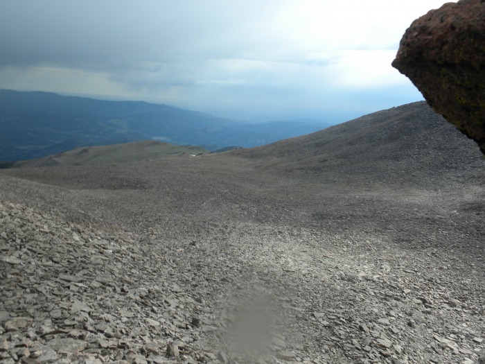
View of the well maintained trial as I'm leaving the boulderfield. It looks like Fort Collins is getting ready to get wet.
a few minutes later, I would be putting my rain gear on again as a squall passes over. Then back to clear and off come the rain gear. Then later, another passing rain cloud and on with the rain gear, and back off again 10 minutes later. On a 3rd time, I put on the rain gear just as the rain went away. I wish the weather would make up it's mind.
Once I got to the Chasm Lake trailhead junction, it was clear skies for the remainder of the hike down. About 40 minutes before I arrived at the trailhead, I could hear several thunder rolls far up the mountain, but it was full sun down here.
I arrived to the trailhead just after 3:00 pm. A great two day trip for sure. The pads of my feet were a little sore after wearing my VVFs, but no blisters like you can get from regular boots or shoes. The next morning, me feet felt fine and I'm ready for the next mountain!
Thumbnails for uploaded photos (click to open slideshow):
Good report. One correction - your pic at Chasm Junction is actually Peacock Pool not Chasm Lake. Chasm Lake is up around the corner, not visible from the junction. Nice find on those ptarmigans!
I felt like I went with you, ooops, guess I'll be going a little later this season. I'm thinking that breaking the trip into two segments makes it more enjoyable and less tired than driving several hours and then hiking/climbing up. Since I'm older, its not about how fast one can get up the mountain, but what you see and experience on the way up that is important to me. Thank you for a great writeup and pictures. ChrisM
Well documented. Interesting about your VFF KSOs. I have been thinking about getting those specifically for Class 3/4 rock based on what I would think would be enhanced grip. So would you say that they grip a lot better than conventional footwear?
Love the baby ptarmigan pic. What a gem to see one of them! Nice details and pictures. Great job getting through the rain. Glad you didn't have lightning.
thanks for the positive replies all. 11/30/2010 5:28pm
randalmartin: I feel that their flexibility puts more rubber on the rock and helps get better grip, but that may be just my opinion, (sorta like a 4x4 airing down the tires while rock-crawling). I don't bound from talus rock to rock like I would in normal shoes, so they slow me down a little in that regard. They weigh about 5-1/2 ounces per foot, so if you find heavy boots on a long hike to be a nuisance, that problem is solved with these. Towards the end of a hike, if I get tired or am not paying attention to the trail and drag a toe on a rock or root in the trail, a stubbed toe wakes me back up. That can hurt for a day or two if this happens during a trail run. They also force you to alter your running technique so you don't jolt your body with heal/ground impacts. That part comes more natural as time, (and miles), go by. There is a break in period; not for the shoes, but for your feet and leg muscles: calves and soleus. You have to run landing on the front 1/2 of your foot, so your arch and your calve/soleus muscles are your new "shock absorbers" now that you aren't landing on 1 inch thick heal pading. As a side note: I was told that continued, constant use over a year or so will greatly strengthen you arches, causing them to highten, and in the process, draw your toes back enough to shorten your feet a 1/2 size smaller. We'll see about that next Spring. Okay, that was probably more information that you were seeking, but there ya go. (I wear the KSO Treks, they have a more rugged sole)
ps... try them on at a store before you buy online. And it can be hard to find them in a store in the more popular sizes and the style you want. Not all stores carry all styles, either. They come in European sizing and your size is based off your longest toe; not the same toe on all people. Good luck and... "Take a hike!" :wink:
You really wore those to the top? I suppose they'd be good for grip. I think you're the first, send Vibram a picture.
Caution: The information contained in this report may not be accurate and should not be the only resource used in preparation for your climb. Failure to have the necessary experience, physical conditioning, supplies or equipment can result in injury or death. 14ers.com and the author(s) of this report provide no warranties, either express or implied, that the information provided is accurate or reliable. By using the information provided, you agree to indemnify and hold harmless 14ers.com and the report author(s) with respect to any claims and demands against them, including any attorney fees and expenses. Please read the 14ers.com Safety and Disclaimer pages for more information.
Please respect private property: 14ers.com supports the rights of private landowners to determine how and by whom their land will be used. In Colorado, it is your responsibility to determine if land is private and to obtain the appropriate permission before entering the property.


")
")
")
")
")
")
")
")
")
")
")
")
")
")
")
")
")
")
")
")
")
")
")
")
")
")
")
")
")
")


