| Report Type | Full |
| Peak(s) |
Pikes Peak - 14,109 feet |
| Date Posted | 07/01/2010 |
| Date Climbed | 06/30/2010 |
| Author | ldperigo |
| Pikes Peak - America the Beautiful |
|---|
SummaryI did route 4.1V1 from Gerry Roach's (1999) book, Colorado's Fourteeners From Hikes to Climbs Second Edition. This is a variation of the "classic" East slope, which involved purchasing a halfway ticket from the Pikes Peak Cog Railway for $10. I camped at Barr Camp. Left camp at 6:00 a.m. reached the summit at 9:00 a.m. (break), returned to camp at 12:00 (break), and returned to my car at 3:00. Total time including stops = 9 hours. Overall Impression: If you are considering this as your first 14er, I personally would not recommend it. This makes for a very long day, or even two days if you camp. I do not feel the payoff is worth the effort for this mountain. However, on the other hand, this is a very popular mountain with close proximity to major cities, and people of all ages and abilities successfully summit this mountain. I believe there are other mountains that are better suited for beginners. Introduction"O beautiful for spacious skies . . ." are the opening lyrics to the historic song, "America the Beautiful," written by Katharine Lee Bates after an inspired trip to Pikes Peak in 1893. I can only imagine what emotions the view atop this mighty mountain would have inspired over a hundred years ago. Today, this magnificent mountain is the background to Colorado Springs, and it is one of the most famous mountains in America. God truly "shed his grace on thee." Everyone worships in their own way. Some people praise God and give him thanks by singing, praying, and reading their bible"all of which are fantastic. Unfortunately, I'm not an extravagant singer, and I can't play a single instrument, even though I know God loves to hear me sing praises to him, however bad my tune may be. For me, I think John Muir put it best when he said, "keep close to Nature's heart . . . and break clear away, once in awhile, and climb a mountain or spend a week in the woods. Wash your spirit clean . . . the mountains are calling and I must go . . . ." When I'm in the mountains and am immersed in the indescribable beauty which our God has created, that's when I am closest to him. That's how I worship. Seeing the outdoor playground God has created for our enjoyment, makes me anticipate heaven with giddy excitement. If you think you understand the beauty of this world, pondering on what God has in store for us in heaven in unimaginable. (I suggest Randy Alcorn's 2004 book, Heaven, for a deeper understanding of what Heaven will be like. We won't be sitting on clouds playing harps, as the often believed cliché goes. However the book is pretty much like reading a text book, so if you want my summary version, please do not hesitate to ask. I will be happy to send it to you.) Trip ReportThis trip report (TR) is written for an audience that is not familiar with the topic, so a lot of explanation will be included, many times in "()." Also, this will be the longest TR I ever do, because it is the first. I would like to thank my good friend Casey Stouffer for introducing me to this Colorado epidemic six years ago, when we first summited La Plata peak together. For my fourth fourteener, or 14er, (mountain that exceeds 14,000 feet elevation above sea level) of the season, I originally decided to do Longs Peak in Rocky Mountain National Park (RMNP). However, after contacting the ranger station in hopes of reserving a camp site in the boulder field, they said it was still considered a technical climb, meaning you still needed crampons and ice axe because of the snow and ice on the route. That is exactly what I wanted because that would mean there would be a limited number of travelers, even though this mountain is hiked more than any other 14er in the state of Colorado (Roach, 1999). I ran into a major problem though when I was packing my gear. I tested my crampons, and did not like the way they fit my boots (I didn't try them on when I bought them). I didn't want to risk mountaineering, solo, in crampons that I wasn't confident in. So, with regret, I looked for another mountain. I decided on Pikes Peak, because of its proximity to Boulder and the fact that Ashley (my beautiful, lady lover) would probably not be interested, due to the overall distance and elevation gain (Pikes Peak has the most elevation gain of any of Colorado's 14ers (Roach, 1999)). So, with my decision made, and the weather looking good, I decided to take off after work for an overnighter in the mountains. Ash was out of town visiting friends, and we have holiday plans for Arches National park this weekend, so I thought I'd head out while I had the chance. (Special thanks to my boss, Noor, for letting me take off work in the middle of the week on relatively short notice). I decided to do a variation of the "classic" East slope from Roach, 1999, (4.1V1) which involved purchasing a halfway ticket from the Pikes Peak Cog Railway for $10. (I chose this route mainly for the sake of time.) They only allow hikers to take the first or last train of the day (8:00 a.m. or 5:20 p.m.). I booked a ticket for the 5:20 ride. I left immediately after work on Tuesday (I packed the night before), and made it to Manitou Springs, with just enough time to spare, after finding parking. They will not allow you to park in the Cogs parking lot, because they know you'll be there overnight, and the parking is very limited, so you have to find a place on the street or just up the road in the Barr Trail lot. I chose the latter. I actually enjoyed the 20 min. I was on the train. The conductor, Whitney, (a college student) was very informative and fun (I'm extremely easily entertained). Two little facts I learned about Pikes Peak and the Cog Railway. First, the state of Delaware can fit inside of Pikes National Forest (PNF), and PNF is only the third largest park in Colorado. The other fact I learned was when the Cog Railway was first built over a hundred years ago, the tickets were $5, which equates to over $100 today. As I mentioned before, I only paid $10 for my ticket. Anyway, they let me off at the Mountain View stop, and when I got off the train the other 200 passengers stared and took pictures like I was Sir Edmond Hillary. It was very comical. From there I crossed the tracks and made my way to Barr Camp at 10,200 ft. elevation. It took me about half an hour to make it to the camp.  I met Neal and Teresa who are the hosts of the camp (barrcamp.com). They were extremely friendly and we chatted for a while. They said they were very slow today. It was just me and one other person camping for the night. I just stopped in to say hello, because I wasn't going to be staying at any of the facilities they managed, I was just going to setup my tent across the stream in the national forest (free of charge). However, they were helpful in pointing me to some of the better locations over there.  I setup my tent and got my site prepared. It was about 7:30 p.m., so there was still about an hour to an hour and a half of daylight left. I brought my book (Red by Ted Dekker, it is the second part of the Circle Trilogy; thanks to my friend Andrew for tipping me off on this series). I read a few chapters, but since I didn't bring my tent (just my rainfly and poles) there were a few small, six-legged, flying friends that joined me in my reading. I didn't know if they could read or not, so I began reading aloud, only to then realize, that maybe they couldn't hear (I'm not an entomologist). I ended up changing my headlamp to night vision (red beam instead of white) and they promptly dispersed from my pages, allowing me to continue reading to myself.  I just realized I haven't wrote much of a TR at this point. Well, for those of you still reading (thanks Mom and Dad), I'll get on with it. I woke up about 5:30 a.m. Wed. and packed my camping gear in my big pack, stashed it away to retrieve on my return trip down, and headed for the summit (6 miles and 6,000 feet of elevation gain) with my Osprey Daylight summit pack (thanks Grandma and Grandpa Anderson for the Christmas gift two years ago). The Barr trail began in the woods and was a gradual uphill for a while. 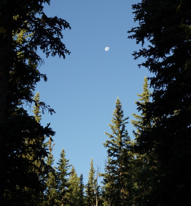 The scenery was nothing spectacular. I was disappointed that the actual trail was so loud. It was almost like crushed gravel, so it made a loud "crunch" with each footfall, so it was nearly impossible to enjoy the serenity of nature. I was hiking solo, so I was at my own pace, which was pretty steady. My heart rate monitor (HRM) (thanks in-laws for the Christmas gift), stayed around the 130s for most of the assent. I reached the tree line (the elevation from 10,500 - 12,000, depending where in the state you are; this is a "line" where trees can no longer obtain enough oxygen to grow; only alpine tundra above this "line") in about an hour I believe. So, from here to the summit I would be completely exposed to the weather.  It was a beautiful day and the temperature was perfect, so the only threat was the sun. I had put plenty of sunscreen on thanks to our (Mom, Dad, and Ash) experience on Grays and Torreys (see that TR too). Above the tree line, the trail abruptly began switchbacks, which did not stop until the summit. Unfortunately, the scenery was not as good as I'd hoped. I'm sure it is because I've been blessed by visiting so many amazing places, that this particular mountain was just not as good as the hype. However, I was hiking for the summit of this mountain, not for the view, but better scenery would have made the arduous journey more enjoyable. There were some pretty yellow and purple flowers scattered along the trail all the way to the summit. I believe the scientific name for the yellow flower is Lilyelltastica, and the purple one is Violetfaunaflowerish, however, I'm not 100% sure that is correct. They were very pretty to look at along the way. I'm sure my mother would have been talking to them as she stepped past. 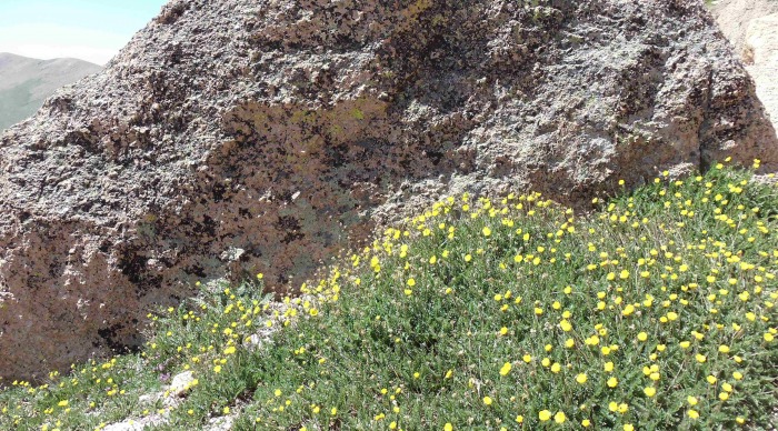 Around 13,000 ft. (thanks Dad for the GPS Christmas present three years ago), I saw some mountain goat tracks in the dusty trail. I followed them for a bit, but they only led to a pile of poo. From the heat and taste of it, I could deduce that it couldn't be more than 30 min. old, but the goat was nowhere in sight. So, while I was off the trail by the poo, I decided it was a good time and place to follow what the goat had done (only I did #1). I made sure to go on a rock, because above tree line the alpine animals are so starved for salt that they will actually destroy any fauna that has been urinated on to obtain the salt. In an effort to protect the yellow and purple flowers I'd come to enjoy, I made sure to aim for a rock, and I'm a pretty good aim, especially when there are about a million rocks to choose from. I would like to add that Pikes Peak has about two-three miles above tree line, so there is not a lot of privacy when it comes to the "call of nature." Lucky for me, I didn't see any other hikers until about 20 min. from the summit, or 2.5 hours into the first part of my journey, so I was free to answer "the call." My next form of excitement came at about 13,700 ft. where I found some recently discarded orange peels. I picked them up for the uneducated person who left them there. I didn't want some alpine animal, like a marmot, to eat the non-native food, and then go on a provisions quest down to the human city in search of the deliciousness he once tasted, only to not find what he was looking for and eventually perish in the winter because he could no longer eat normal marmot food (this was a modified quote from Whitney Ballinger). Anyway, I packed the peels out in hopes of saving the marmot; I just pray I didn't miss any pieces.  This is definitely the longest "TR" ever. I'll wrap up this nonsense.  Meanwhile back on the trail, I saw the sign "16 Golden Steps." I knew I was near the summit, but this sign is very misleading. I think it should say "16 Hundred Golden Steps." This was the hardest part of the climb by far. The trail became very steep and literally had a lot of steps made of stone throughout. At this point I heard the "toot-toot" of the trail, and I saw it pull up. I realized how close I was, and it made the final part motivating. 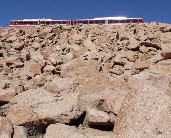 I was very disappointed with the summit. They views were not as good as any of the others I've visited. It was a nice sight to see a mangy fox at the top, though. I'm pretty sure it was a fox, it is hard to tell for sure because I also heard it called a coyote and even a cat by the some of the other 300 people at the summit. I guess it could have been a wolf or mountain lion too.  I reached the summit at 9:00 a.m., just about three hours after I left my camp site. I thought I was going pretty fast, until I was passed by at least half a dozen people who were running it . . . literally. It was kind of insulting; one of them had to be pushing 90 years old. I also was passed by three people on mountain bikes, while I'm being honest. (I figured no one was reading at this point, so it doesn't matter how bad I look).  On the way down, I stopped at Barr camp and picked up my "heavy" pack. It was probably only 20 lbs. I packed my hiking poles (thank you Grandma Shirley and Grandpa Jim for my Christmas gift), and I'm glad I did. I knew my legs and ankles would be getting tired by this point, and with the addition of my heavy pack and seven more miles to go down, I thought they would come in handy. I was right. I came very close to rolling my ankles several times, which would have been devastating since I was by myself"it would have been a long hop down with a pack on my back. I didn't have my favorite hiking socks (the little black ones you get to keep when you rent a $165 tuxedo), so I had to use some others. They got soaked on the summit trip and rubbed some pretty good sized blisters, but thankfully I had my "summit" first aid kit which had a few blister pads in it (one for each foot). Then when I got to my real pack I was able to get my real kit, and use all four of the pads from it for my four matching blisters. My feet were in bad shape. I changed socks too.  Finally, I just had seven miles to go, to round out 19 for the day. I didn't think the scenery was much different or any better than what I get to see every day, and as Ashley says, "I'm just ready to get down." At this point, I was just ready to get down. So, I went at a pretty good clip. I put in my iPod (thanks Ash for the birthday present two years ago), and played some of the compilations my friend Corey made for me, and just headed for the Jeep. Occasionally, I would get annoyed between songs because I could hear how loud my footsteps were on the gravel-like trail (I don't know why that bothered me so badly, it's not like I was going to see any wildlife or have any since of solitude on a trail 500 other people were on). I made it all the way down, and the total trip was about 9 hours including a stop at the summit for a snack, and a stop at Barr camp for another snack. My average HRM stats were: 134 summit (3 hours), 132 decent to Barr camp (2 hours), and 136 from Barr camp to the trail head (2 hours). Thumbnails for uploaded photos (click to open slideshow): ")
")
")
")
")
")
")
")
")
")
")
")
|
| Comments or Questions |
|---|
|
|
Caution: The information contained in this report may not be accurate and should not be the only resource used in preparation for your climb. Failure to have the necessary experience, physical conditioning, supplies or equipment can result in injury or death. 14ers.com and the author(s) of this report provide no warranties, either express or implied, that the information provided is accurate or reliable. By using the information provided, you agree to indemnify and hold harmless 14ers.com and the report author(s) with respect to any claims and demands against them, including any attorney fees and expenses. Please read the 14ers.com Safety and Disclaimer pages for more information.
Please respect private property: 14ers.com supports the rights of private landowners to determine how and by whom their land will be used. In Colorado, it is your responsibility to determine if land is private and to obtain the appropriate permission before entering the property.

