Download Agreement, Release, and Acknowledgement of Risk:
You (the person requesting this file download) fully understand mountain climbing ("Activity") involves risks and dangers of serious bodily injury, including permanent disability, paralysis, and death ("Risks") and you fully accept and assume all such risks and all responsibility for losses, costs, and damages you incur as a result of your participation in this Activity.
You acknowledge that information in the file you have chosen to download may not be accurate and may contain errors. You agree to assume all risks when using this information and agree to release and discharge 14ers.com, 14ers Inc. and the author(s) of such information (collectively, the "Released Parties").
You hereby discharge the Released Parties from all damages, actions, claims and liabilities of any nature, specifically including, but not limited to, damages, actions, claims and liabilities arising from or related to the negligence of the Released Parties. You further agree to indemnify, hold harmless and defend 14ers.com, 14ers Inc. and each of the other Released Parties from and against any loss, damage, liability and expense, including costs and attorney fees, incurred by 14ers.com, 14ers Inc. or any of the other Released Parties as a result of you using information provided on the 14ers.com or 14ers Inc. websites.
You have read this agreement, fully understand its terms and intend it to be a complete and unconditional release of all liability to the greatest extent allowed by law and agree that if any portion of this agreement is held to be invalid the balance, notwithstanding, shall continue in full force and effect.
By clicking "OK" you agree to these terms. If you DO NOT agree, click "Cancel"...
West Face II, Class II, Moderate Snow
Trailhead: Matterhorn Creek Trailhead
Distance and Elevation: From Matterhorn 2wd parking - 10 miles, 4,300 feet elevation gain
Climbing party: Jamie P (Shanahan 96) and Mark M (yours truly)
Uncompaghre is the 6th highest peak in Colorado. It is the highest point of the San Juan Mountains. Uncompahgre is a combination of three Native American words: unca (hot), pah (water), and gre (spring), as per "The Origin of Certain Place Names in the United States", by Henry Gannett. While I may have wished for a hot spring after this climb, I certainly did not see any while on this mini-adventure.
I got a phone call from Jamie about a month ago, asking if I was interested in the West Face of Uncompaghre. Considering this option was not a standard slog route, but instead a spicy alternative to the norm via a snow covered face and climbs directly up the peak, the obvious answer was an enthusiastic YES!
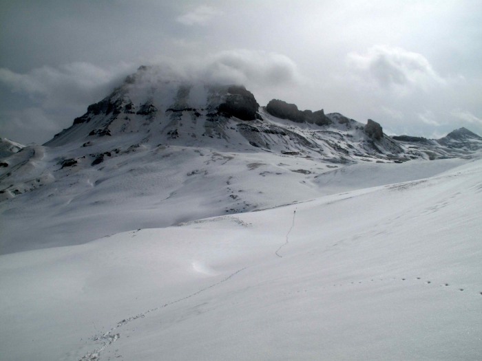
Halfway point up the West Face
We left Denver after work on Thursday, pulled into Subway for a quick bite and a pre-made lunch for the climb, and who walks in but Steve Vets! He was scheduled to meet with us for a climb on Friday night at our camp to join forces for the East Face of Wetterhorn on Saturday. I half-jokingly asked Steve to bring us some Pizza Hut for dinner on Friday night, and he said agreed! SCORE! No dehydrated food on this trip, big bonus!
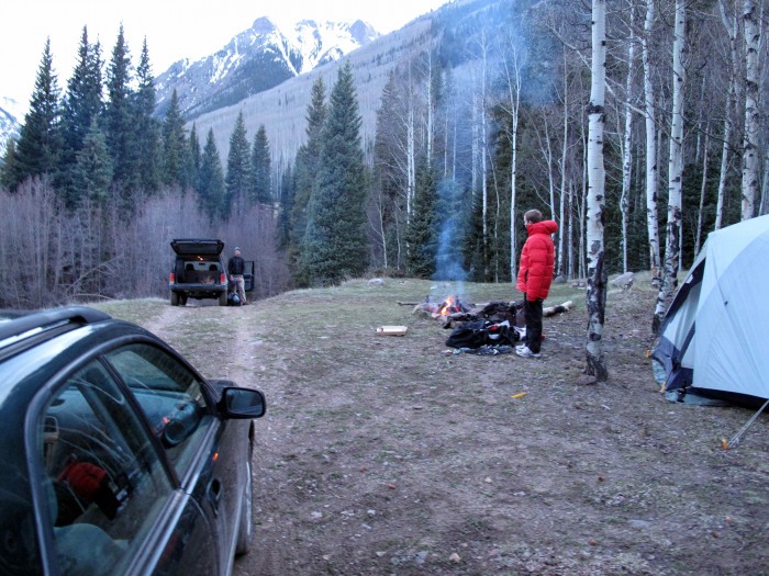
Camp at Capitol City
After an uneventful drive in to camp near the Capitol City ruins, we set up our tent under a blackened sky spitting snow and tried to fall quickly asleep. Our goal was to awaken early for a speedy assault on the West Face, but due to a somewhat quiet watch alarm and our exhausted states, we did not wake up until roughly 6 am. We rushed about trying to get ready, stumbling around half-asleep and then drove up to the 2wd trailhead.
It was snowing quite steadily and was somewhat cold as we were strapping axes, snowshoes, shovels, etc to our packs. There was a very low ceiling and visibility was very poor. I had doubts on whether we would actually be successful in these conditions, however, it provided a somewhat eerie yet inviting atmosphere, and we were determined.
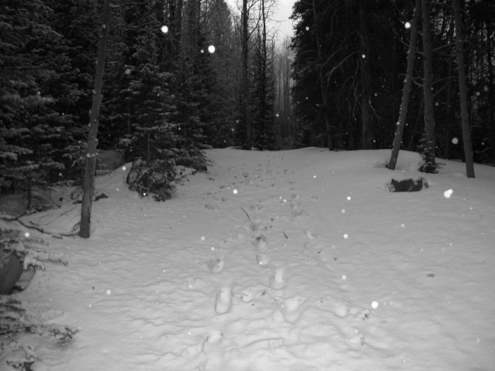
Trail start
We started up the 4wd road and soon encountered a downed tree blocking the road along with numerous snow drifts that would quickly block all but the most monstrous of trucks! I imagine someone will take a chainsaw up and take care of the demised conifer, and mother nature will take care of the rest soon enough. I was starting to get a little agitated at the snow because once we were moving, I was very warm, but yet had to keep a shell on to keep from getting soaked. Hiking up in a sauna bubble is not part of my 'favorite things to do list', but nonetheless, perserverence was key so I kept the internal grumbling to a minimal while trying unsuccessfully to keep pace with Jamie, chilling to some of Leonard Cohen's early, acoustic bluesy-goodness.
Misty views
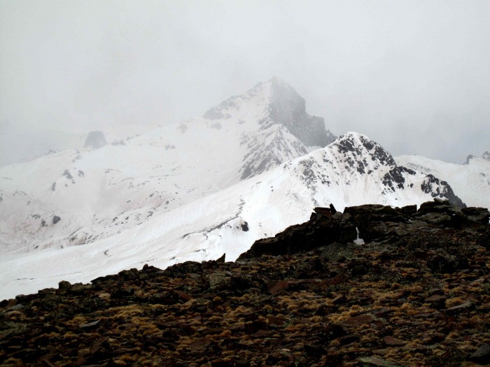
As we broke treeline, hope sprung in the form of a breaking sky as Matterhorn Peak was poking through the misty veil of the early morning storm.
Matterhorn makes an appearance
A few more minutes and Wetterhorn was also dominating the landscape in fleeting glimpses of mountain majesty.
Wetterhorn shrugs off it's veil
I was quite humbled and enthralled, as this was my first time in this area. This greatly lifted my spirits and I switched over to some more upbeat, Wolfsheim for this section to the 12,458 foot pass, which is also the Continental Divide.
Continental Divide
Forward progress
Now our goal was in view and I stood in silence and respect for this San Juan giant. As usual, Jamie was forging ahead with his typical quickness, so I could not sit there and drool for too long, as there was a climb to get on!
The way forward
We chose the southernmost of the three gullies to ascend (climbers right), fueled up with some disgusting, soggy, and utterly unappetizing sandwich (which happened to be wrapped in Subway garb), geared up with crampons and ice axe, stashed our snowshoes, and began our ascent.
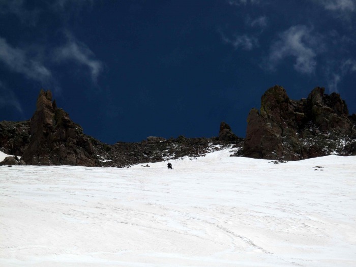
Start up the face
View south near the beginning
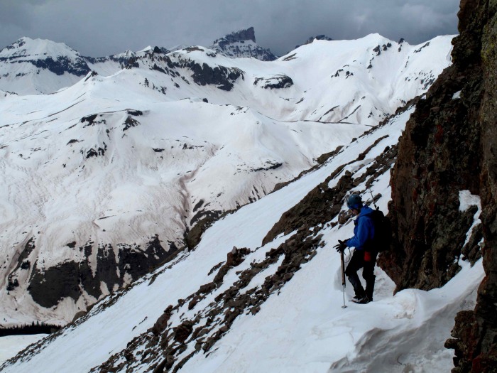
It was straightforward climbing on some solid, consolidated snow. Initially it was perhaps (according to my internal inclinometer ) 35 degrees, angling to roughly 40 degrees (with some slightly steeper parts) after the first chokepoint and remaining steady after that.
Face begins to steepen
Another view of the majestic San Juans
I was not feeling my best and was bonking pretty hard. I had barely been able to get any of my sodden food down and my stomach thought it was a good time for some deathmetal auditions, complete with a mosh pit cacaphony. Needless to say, not my strongest day climbing. Jamie was strong and forged ahead, making quick work of this long face.
Jamie making tracks!
Soon we were through the upper rock pinnacles that guard the broad shoulder, upon which the standard route lay.
Steepest part before pinnacles
After the pinnacles, there was some minor scrambling to be had on loose rock and snow, but nothing too intense.
Scramble through pinnacles
Once through this, the views of the San Juans were magnificent as usual! A stunning reminder of why the suffering is all worth it.
San Juan views
However, the quasi-triumph over this eruption of earth was short lived as fresh storm squalls were angrily making their way accross the valley to our lofty perch.
Squall incoming!
I watched as one engulfed Wetterhorn and Matterhorn, targeting us as it's next victims.
Wetterhorn getting engulfed
Me with the summit behind
The summit views were, unfortunately, nothing but views of grey sky and moss rock playing to the soundtrack of the wind. Regardless, it was a sweet victory, as the halfway point of our journey had been reached. I was to be denied any visual pleasures from this ascent until later in the day.
STOKED =D
We snapped a few pictures, more for ritual than for any other reason, and then scurried down to get out of this maelstrom.
Sure enough, upon reaching the shoulder, the storm abated and we had views again. I thought about going back up to the summit, but seeing as there were numerous other storms swirling about, I felt it most prudent to continue the descent with my partner down the west face. Our glissade tracks looked like a giant you-know-what stain behind us due to the desert dust coating.
Clearing squall (of course)
We took turns glissading for safety's sake. Sliding down to each choke point and waiting for the other, and then continuing on.
About to glissade
At the base of the climb, we congratulated each other, and Jamie took off to climb another 13er on the way back to the trailhead. Ah to have 6 years of youth back and a cross country runner's physique!!! I elected to just follow our track, meandering back to the trailhead where we would meet up.
Streaking!
I was treated to some magnificent views, including a coyote, magic ferns and other wonderous things that forced me to take way too many pictures! When I got the trailhead, Steve pulled up with the pizza...talk about good timing! Thanks Steve!
Some other pictures taken from the area
Majestic Wetterhorn sheds the remnants of the last storm
Wetterhorn looking sexy
Tendrils of a frozen wonderland
Frozen branches
Sweetleaf
Medicinal Fuzzijuana Fern20
Remnants of a time past
Is there anybody out there?
Just knock if you can hear me...
Thanks for reading, see you on the trail!
Thumbnails for uploaded photos (click to open slideshow):
Nicely done, you guys! You should be more than primed and ready to winch my fat behind up a couple of little mountains this weekend! Beautiful pics, Mark, too bad the skies did not cooperate. As with all of the San Juans, the view on a clear day from that mountain is ridiculous.
...helped paint that canvas, along with steep slopes, a stairway to heaven, a ghost town, spectacular mountains - man, your report captures the beauty of what we do at it‘s finest. A nicely done climb and report. The last photo is a great way to end. Is that door closing on an adventure, or opening to many more? Thanks for posting this beautiful report.
West Face was something we strongly considered when we skied that windblown, skier‘s nightmare a few springs ago. Iconic mountain that demands your attention, your camera (did you get a new one ? awesome shots) definately captured the historical and visual significance of that region of the San Juans. Sweet job Mark. I also think some of the most destructive avy paths exist around that region, I distinctly remember seeing the most amazing and terrifying aftermath of a 2500 foot chute emptying out on poor Nellie Creek Rd. Any human in that path would‘ve been vaporized. You are right man, no car created by man is any match for that quagmire.
Well, Mark, I‘d have to say that G10 in your hands is deadly dynamite. Nice to see some artistic shots in a trip report - have to agree with Kimo here - some really nice shots. I like the treatment you gave to #26. It looks like a painting. Knocks me out.
Looks like a fun climb. Thanks for a great report!
I appreciate the kind words! It‘s been a while since I‘ve written up a report here, but I saw very little beta on this route and thought I would contribute. I had help with Mother Nature on this trip as far as the photography goes!
Just sat down and read this, nice work getting a non-standard route on Uncompahgre. Your photos are sweet, my favorite is second from the end of the ghost town on the way up, very cool. Nice job!
Mark, Mario‘s also exists in the land of Stevevets. Pizza Hut?
Just kidding. Given this was your first time down there and your musical choices, I hope this wasn‘t ”Once in a Lifetime” for you.
Those photos range from just awesome (especially the B&W) to hilarious (fuzzijuana). Thanks for an effusive, yet honest account of a solid day.
Caution: The information contained in this report may not be accurate and should not be the only resource used in preparation for your climb. Failure to have the necessary experience, physical conditioning, supplies or equipment can result in injury or death. 14ers.com and the author(s) of this report provide no warranties, either express or implied, that the information provided is accurate or reliable. By using the information provided, you agree to indemnify and hold harmless 14ers.com and the report author(s) with respect to any claims and demands against them, including any attorney fees and expenses. Please read the 14ers.com Safety and Disclaimer pages for more information.
Please respect private property: 14ers.com supports the rights of private landowners to determine how and by whom their land will be used. In Colorado, it is your responsibility to determine if land is private and to obtain the appropriate permission before entering the property.


")
 Halfway point up the West Face")
 Camp at Capitol City")
 Trail start")
 Misty views")
 Matterhorn makes an appearance")
 Wetterhorn shrugs off it's veil")
 Continental Divide")
 Forward progress")
 The way forward")
 Start up the face")
 View south near the beginning")
 Face begins to steepen")
 Another view of the majestic San Juans")
 Jamie making tracks!")
 Steepest part before pinnacles")
 Scramble through pinnacles")
 San Juan views")
 Squall incoming!")
 Wetterhorn getting engulfed")
 Me with the summit behind")
 STOKED =D")
 Clearing squall (of course)")
 About to glissade")
 Streaking!")
 Wetterhorn looking sexy")
 Frozen branches")
 Medicinal Fuzzijuana Fern20")
 Is there anybody out there?")
 Just knock if you can hear me...")


