Download Agreement, Release, and Acknowledgement of Risk:
You (the person requesting this file download) fully understand mountain climbing ("Activity") involves risks and dangers of serious bodily injury, including permanent disability, paralysis, and death ("Risks") and you fully accept and assume all such risks and all responsibility for losses, costs, and damages you incur as a result of your participation in this Activity.
You acknowledge that information in the file you have chosen to download may not be accurate and may contain errors. You agree to assume all risks when using this information and agree to release and discharge 14ers.com, 14ers Inc. and the author(s) of such information (collectively, the "Released Parties").
You hereby discharge the Released Parties from all damages, actions, claims and liabilities of any nature, specifically including, but not limited to, damages, actions, claims and liabilities arising from or related to the negligence of the Released Parties. You further agree to indemnify, hold harmless and defend 14ers.com, 14ers Inc. and each of the other Released Parties from and against any loss, damage, liability and expense, including costs and attorney fees, incurred by 14ers.com, 14ers Inc. or any of the other Released Parties as a result of you using information provided on the 14ers.com or 14ers Inc. websites.
You have read this agreement, fully understand its terms and intend it to be a complete and unconditional release of all liability to the greatest extent allowed by law and agree that if any portion of this agreement is held to be invalid the balance, notwithstanding, shall continue in full force and effect.
By clicking "OK" you agree to these terms. If you DO NOT agree, click "Cancel"...
Even with some uncertainty about the recent conditions in the Sangres, I loaded up the car on Monday morning and headed for the S. Colony trailhead. I left Colorado Springs around 4am, and was at the Upper 2WD trailhead by 6:20am. I couldn't see any of the peaks on my approach, so I still wasn't sure how much snow, if any, remained on the peaks. I actually drove past the open gate at the newly maintained trailhead, crossed the creek, and started to head up the road - but quickly realized that my Forester wasn't up for this challenge. I parked a few paces past the creek crossing.
By 6:30am I was slogging up the trail.
First Light
As daylight broke and I caught glimpses of Broken Hand Peak and Crestone Needle, I was surprised and encouraged at how little snow remained.
By 7:30 I had passed the 4WD trailhead and was headed for the standard Crestone Needle route. There were several people camping along the trail, but I would see no one else on the entire route.
Humboldt Peak
The sun spilled into the valley and warmed everything quickly - I shed layers like it was nobody's business. The mountain pikas were awake, squeaking, and climbing all over the place.
The Needle and the Lake
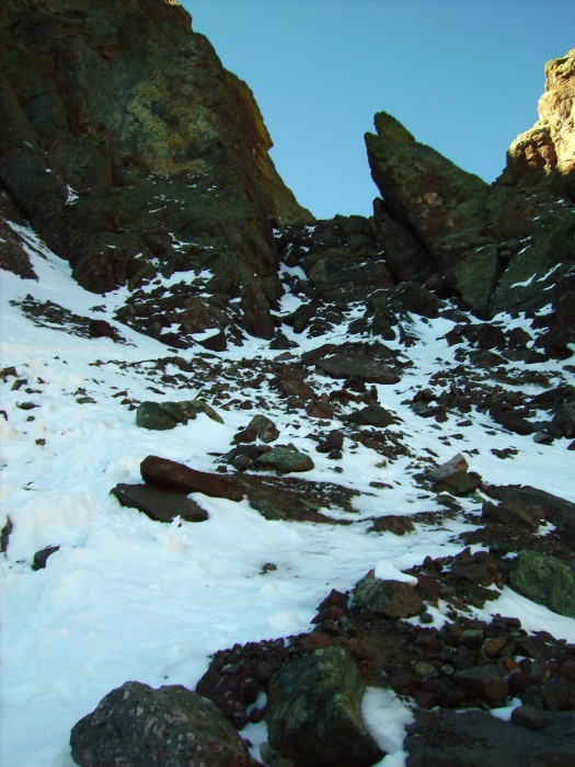
As the route elevates along the north face of Broken Hand Peak the sun is blocked and there is still several inches of snow and ice. I had an ice axe and Microspikes that were helpful during the approach to Broken Hand Pass. (Even on the my return, not much of the snow had melted, and I would guess its there to stay).
Large Cairns on the approach to Broken Hand Pass
Looking back down the route
Getting closer!
The first obstacle was easily negotiated and the snow/ice didn't present to much of a hassle. I was soon over Broken Hand Pass and continued on towards the East Gully. The wind picked up here and would gust inconsistently for the rest of the climb.
Past the first obstacle.
Looking back down at Broken Hand Pass
The East Gully had a good amount of flowing water from the snowmelt. The route up was well-cairned and I didn't have too much trouble on the crossover to the West gully. Most of the snow could be avoided, but some spots were pretty sketchy. I had couple slips on loose rock and was thankful no one was behind me! I was in no rush though so I continued to proceed cautiously.
Getting tired here
I crested the west gully and was on the summit by 11:45am. I should mention that I saw footprints in the snow on several "alternate" routes that would have had me freaking out. On top the sky was clear and there were great views all around.
Broken Hand Peak
North to Crestone Peak
Humboldt
After spending about 1/2 hour on the summit I started down. This proved more interesting than the ascent. Despite the warnings on this site's route description and others, I somehow missed the entrance to the west gully. I actually started too far west and had some difficult class 3 and class 4 moves ahead once I realized I wasn't where I was supposed to be. Luckily there was a weakness in the rib separating me from the west gully and I was able to cross over and downclimb a steep section into the west gully. The descent was also more difficult with the snow/loose rock than the ascent had been - and I was thankful not to be kicking rocks down on anyone who might have been on the mountain with me. After exiting the gully the climb was uneventful and I was back at the 4WD trailhead by 2:50PM.
One last look at the Needle
The trail register had a few names in it headed for Humboldt, but I only saw a few other campers near the trailhead.
I made it back to the car around 3:40 and was happy to relax after a rewarding day in the Sangres.
The creek was higher than I realized it was in the dark. Not sure I'd cross it again, I think I'll just in the new lot - a wait, I'll have to.
Thumbnails for uploaded photos (click to open slideshow):
to go solo. Great job. And nice self-portraits.
We were up there the day before and went for Kit Carson. What a beautiful fall this has been (after the 4 days of rain/snow left!)
Congrats on your successful Needle climb.
on climbing Crestone Needle this year on the 12th of Sept. because of some fresh snow at high elevation. Did not want to risk it on snow, alone. Congrats, nice photos.
That first shot of the Needle and the lake.... 10/2/2009 8:53pm
is unbelievable. Good report. And a reminder how quickly conditions can change this time of year - sometimes for the better.
Caution: The information contained in this report may not be accurate and should not be the only resource used in preparation for your climb. Failure to have the necessary experience, physical conditioning, supplies or equipment can result in injury or death. 14ers.com and the author(s) of this report provide no warranties, either express or implied, that the information provided is accurate or reliable. By using the information provided, you agree to indemnify and hold harmless 14ers.com and the report author(s) with respect to any claims and demands against them, including any attorney fees and expenses. Please read the 14ers.com Safety and Disclaimer pages for more information.
Please respect private property: 14ers.com supports the rights of private landowners to determine how and by whom their land will be used. In Colorado, it is your responsibility to determine if land is private and to obtain the appropriate permission before entering the property.


")
")
")
")
")
")
")
")
")
")
")
")
")
")
")
")
")
")
")
")
")
")