Download Agreement, Release, and Acknowledgement of Risk:
You (the person requesting this file download) fully understand mountain climbing ("Activity") involves risks and dangers of serious bodily injury, including permanent disability, paralysis, and death ("Risks") and you fully accept and assume all such risks and all responsibility for losses, costs, and damages you incur as a result of your participation in this Activity.
You acknowledge that information in the file you have chosen to download may not be accurate and may contain errors. You agree to assume all risks when using this information and agree to release and discharge 14ers.com, 14ers Inc. and the author(s) of such information (collectively, the "Released Parties").
You hereby discharge the Released Parties from all damages, actions, claims and liabilities of any nature, specifically including, but not limited to, damages, actions, claims and liabilities arising from or related to the negligence of the Released Parties. You further agree to indemnify, hold harmless and defend 14ers.com, 14ers Inc. and each of the other Released Parties from and against any loss, damage, liability and expense, including costs and attorney fees, incurred by 14ers.com, 14ers Inc. or any of the other Released Parties as a result of you using information provided on the 14ers.com or 14ers Inc. websites.
You have read this agreement, fully understand its terms and intend it to be a complete and unconditional release of all liability to the greatest extent allowed by law and agree that if any portion of this agreement is held to be invalid the balance, notwithstanding, shall continue in full force and effect.
By clicking "OK" you agree to these terms. If you DO NOT agree, click "Cancel"...
Report Type
Full
Peak(s)
East Desolation Peak - 12949
West Desolation Peak - 12918
While my usual hiking buddies were off hiking the Wilson Group, I opted to try a peak closer to home this weekend. Wanted
something that would challenge my route finding and scrambling abilities. Desolation Peaks in Rocky Mt National
Park fit the bill nicely.
To get there, take Fall River Road in RMNP 6.5 miles to the Chapin Pass trailhead. This is also the trailhead for Chapin,
Chiquita, and Ypsilon Mts. On the way to the trailhead, I was treated to the sight of 4 male bighorn sheep foraging on the
side of the road.
Only 1 other car was in the parking area when I arrived at 6:30am. According to Lisa Foster's excellent hiking book on RMNP called
"Rocky Mountain National Park: The Complete Hiking Guide".the best route is to follow a trail from 11,050 to the 12,000+ saddle
between Chapin and Chiquita. The day started out fairly overcast, so I tried to hustle as much as possible to this saddle. After
reaching this saddle, Foster's recommendation is to skirt Chiquita on the west side to the 12,800 foot saddle between Chiquita and Ypsilon.
This is exactly what I did. The going was fairly smooth. It was mostly grasses alternating with some rockfields here and there.
I did not go quite as high as the saddle, which was a minor mistake, but I didn't know that at the time.
The next section of the hike was to go around Ypsilon on the west side. The going at first was fairly simple until I started hitting
the north side of Ypsilon. The slopes steepened considerably and made for some pretty awkward off camber traveling. Had to make
the occasional class 2+ move. Had I been higher up on Ypsilon, where the slopes were less steep, I could've avoided these difficulties
altogether. All in all, I was satisfied with my progress. It was still just before 8:30am, and my objective, Desolation Peaks
was right in front of me.
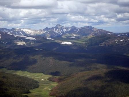
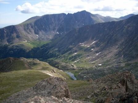
The view from the Ypsilon-Desolation saddle:
Had spectacular views of some of the Never Summer Mountains,
including Mt Richtofen and Nokhu Crags.
After about another mile of traveling up and down a mostly talus ridge, West Desolation Peak was right in front of me.
It looked like the most direct route involved class 5 climbing, so I skirted around to the north and lucked out into finding some
cairns. The cairn trail ran out on the Northeast side of the peak. To my left was a 40 foot gully that appeared to be climbable.
It turned out to be about a short, steep, airy class 3 scramble to the summit plateau. It felt like a miniature version
of the Wetterhorn summit block. Walked across the summit plateau to the true summit, which stood about 10 feet above the rest of
the plateau.
The weather wasn't looking too great and I was anxious to get to East Desolation Peak, so I didn't linger at the summit at all.
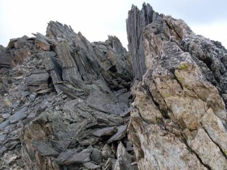
There were really cool looking fins(?) that lined the ridge. I tried staying as close to them as possible. Entered a gulley with
some nice class 2/3 climbing. The rock was solid and exposure was minimal.
After exiting the gulley, I picked up a trail of cairns again. The route varied between class 2 and easy class 3. After the saddle
between West and East Desolation, the route was very straightforward. I did circumnavigate the 15 foot summit block. My first
reaction on reaching it was that it looked too tough to be only class 3+ as described in the book. It was much easier to climb that it
appeared on first glance. It felt pretty exposed up there. The summit itself was very small. The views were incredible from up there.
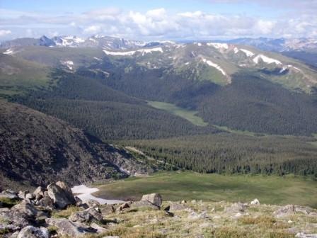
Looking north:
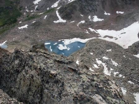
Looking south and below:
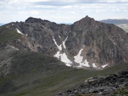
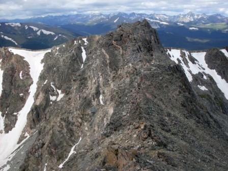
Looking at the Desolation ridge from the East Desolation Peak summit:
Since this ridge is not a good place to be when weather rolls in, I could only visit the summit for about 10 minutes. Getting off the
summit block was easier than I had thought. I faced out and just let my feet slide down to the sizable footholds in the rock.
After the saddle, I opted to go left of the gulley rather than go straight. It was very exposed and loose, not much fun at all. I wish I had chosen to stay as close to the middle of the ridge as possible.
The way back was fairly straightforward. I debated about heading towards the trees directly below and then make my way south back to the
trailhead. If the weather started looking really bad, that would've been the escape route. Instead, at the Ypsilon-Desolation saddle, I
gained some elevation and headed directly towards the Ypsilon-Chiquita saddle. From there, I opted to climb to the top of Chiquita, a soft
ranked 13er in the park. I did this because it was less than 300 feet elevation gain to the top of Chiquita, the views from there are
fantastic, and there is a good trail the rest of the way back.
Saw 5 people on the summit of Chiquita, the only people I saw all day. Didn't get to stay too long on Chiquita because
the weather started becoming a more serious issue. Everyone who was on Chiquita booked down to treeline at an impressive pace.
All in all, a very satisfying day on Desolation Peaks. There wasn't too much sustained climbing on this one, but there was enough route finding,
exposure, and a thrilling summit block to keep things interesting.
Thumbnails for uploaded photos (click to open slideshow):
I like trip reports like this. It‘s these undiscovered gems and rare routes that really capture my imagination.
Lisa Foster‘s book is excellent. I just got a copy a few weeks ago and haven‘t been able to put it down. I think my goal of climbing the 14ers has been extended a few years so I can enjoy the rare peaks that are so much closer to home.
That really is a wonderful place to be. Good call on not heading to the trees. When I climbed the Desolations, we dropped into the trees on the way back and ended up with a miserable bushwhack.
I agree on Lisa Foster‘s book. It‘s a must get if you do a significant amount of hiking in the park.
Those trees did indeed look pretty tight and not fun to wade through, even from up high.
Devo, nice job on Sneffles and Mt Wilson!
Caution: The information contained in this report may not be accurate and should not be the only resource used in preparation for your climb. Failure to have the necessary experience, physical conditioning, supplies or equipment can result in injury or death. 14ers.com and the author(s) of this report provide no warranties, either express or implied, that the information provided is accurate or reliable. By using the information provided, you agree to indemnify and hold harmless 14ers.com and the report author(s) with respect to any claims and demands against them, including any attorney fees and expenses. Please read the 14ers.com Safety and Disclaimer pages for more information.
Please respect private property: 14ers.com supports the rights of private landowners to determine how and by whom their land will be used. In Colorado, it is your responsibility to determine if land is private and to obtain the appropriate permission before entering the property.


")
")
")
")
")
")
")
")


