Download Agreement, Release, and Acknowledgement of Risk:
You (the person requesting this file download) fully understand mountain climbing ("Activity") involves risks and dangers of serious bodily injury, including permanent disability, paralysis, and death ("Risks") and you fully accept and assume all such risks and all responsibility for losses, costs, and damages you incur as a result of your participation in this Activity.
You acknowledge that information in the file you have chosen to download may not be accurate and may contain errors. You agree to assume all risks when using this information and agree to release and discharge 14ers.com, 14ers Inc. and the author(s) of such information (collectively, the "Released Parties").
You hereby discharge the Released Parties from all damages, actions, claims and liabilities of any nature, specifically including, but not limited to, damages, actions, claims and liabilities arising from or related to the negligence of the Released Parties. You further agree to indemnify, hold harmless and defend 14ers.com, 14ers Inc. and each of the other Released Parties from and against any loss, damage, liability and expense, including costs and attorney fees, incurred by 14ers.com, 14ers Inc. or any of the other Released Parties as a result of you using information provided on the 14ers.com or 14ers Inc. websites.
You have read this agreement, fully understand its terms and intend it to be a complete and unconditional release of all liability to the greatest extent allowed by law and agree that if any portion of this agreement is held to be invalid the balance, notwithstanding, shall continue in full force and effect.
By clicking "OK" you agree to these terms. If you DO NOT agree, click "Cancel"...
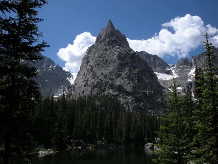
Lone Eagle Cirque from the Monarch Lake TH
Starting elevation: 8,440'
Crater Lake elevation: 10,320'
Roundtrip distance: 14.5 mi
I had been meaning to hike up to Lone Eagle Cirque for about a year now and finally made it. It is one of the most spectacular hikes in Colorado so I thought I'd share it with you.
The cirque is located in the Indian Peaks Wilderness and can be reached from either the east or west side of the Divide. I hiked in from the west side at the Monarch Lake TH which is on the southeast side of Lake Grandby. The turnoff from HW 34 is FR 125 (Arapaho Bay), about 5 miles after the junction of HW 40 and 34. Follow an excellent dirt road about 10 miles to the Monarch Lake TH.
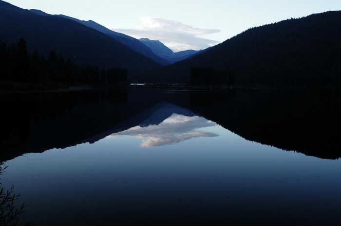
Monarch Lake in the predawn glow:
From the east side of the Divide you would hike in from the Long Lake TH near Brainard Lake. From the east it is about a 20 mile roundtrip hike, from the west about 15 miles. I chose the west side because I had read of the spectacular waterfalls along Cascade Creek.
After leaving the Monarch Lake TH, follow the well-signed trail around the lake and enter the Indian Peaks Wilderness. There are many trail junctions along the way but the desired path is clearly marked.
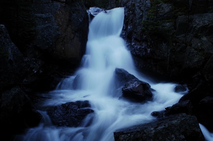
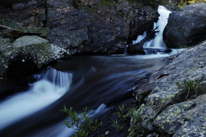
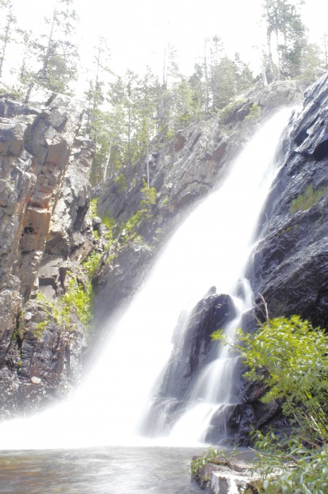
I had read of three superb waterfalls along Cascade Creek, but I counted five photo-worthy falls, plus another nearer the cirque.
To get good photos of the falls, start early as once the sun hits them it becomes much more difficult to take long exposures.
There are two lakes in the basin of the cirque...Mirror Lake and Crater Lake. Mirror is the first reached and the smaller of the two. Crater is the larger and seemed to have excellent fishing opportunities. Lone Eagle Peak is simply spectacular. I didn't climb it (my dog does NOT like class 4!) but hope to return for the Solo Flight route someday soon.
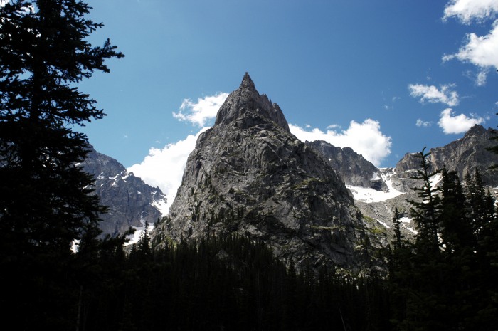
Lone Eagle Peak:
For the runners out there, this trail is entirely runnable on excellent singletrack the whole way. It gets a little rocky toward the top but not too bad. And the 2200' of gain over 7 miles makes for a nice gradual ascent. Also, the wildflowers are spectacular at the moment.
On the hike out we saw this cow moose near the trail. I was not able to get a good picture before she wandered off.
Thumbnails for uploaded photos (click to open slideshow):
I love that cirque. Lone Eagle Peak is iconic - and certainly earns it‘s namesake. I made that long hike to Crater Lake twice last summer just to stand/sleep/eat/wonder beneath that peak. The first time on a weekend in early July the designated tentsites (I think there are eight or nine of them) were half empty. The second time, over Labor Day weekend, there were still a few empty sites available. Not sure why that is considering the area is speckf‘ntacular gorgeous! Maybe the hike distance?
I literally ran into two moose on the trail in. I was hiking with the headphones on, not really paying attention, and I came across four little legs standing in the middle of the trail. I looked up and saw baby moose. I looked further up and saw momma moose. She looked at me like I was a dead man. I have never ever jumped so far and so fast. When I peered back over the big boulder beside the trail there was nothing. Momma and kid disappeared with the grace of a ballerina.
If you have a DSLR, look into getting a neutral density filter. It will allow you to take long exposure shots with sun. I have a graduated ND filter, which helps with bright sky and dark surroundings.
The place is awesome-I recommend lots of mosquito repellant. We went 3 weeks ago in the afternoon- started at 3:30 and were up at the cirque about 1 hour before sunset (amazing light). Hiked back for 2 hrs in darkness which also was fun. The shadows are long there so plan to be at the final 2 lakes at least 1.5 hrs before sunset for best light.
Awsome pics. Went up there last year and tried to ski Fair glacier which is the one on the lookers left of lone eagle. Too much blue ice and a huge crevase at the bottom so we opted out. Just wondering if you got a good look at the condition of Fair, me and a buddy are planning to hike up there in the next month and try to ski Fair or Peck glacier.
I was just up there last weekend and I totally agree with you in how spectacular that area is. I also had my dog so I couldn‘t do anything technical, but simply seeing the waterfalls and chilling out by the lake was enough to satisfy me and my dog. Let me know if or when you plan on climbing Lone Eagle and need a partner or two.
from my vantage down by the lakes, the glaciers looked tiny.
Caution: The information contained in this report may not be accurate and should not be the only resource used in preparation for your climb. Failure to have the necessary experience, physical conditioning, supplies or equipment can result in injury or death. 14ers.com and the author(s) of this report provide no warranties, either express or implied, that the information provided is accurate or reliable. By using the information provided, you agree to indemnify and hold harmless 14ers.com and the report author(s) with respect to any claims and demands against them, including any attorney fees and expenses. Please read the 14ers.com Safety and Disclaimer pages for more information.
Please respect private property: 14ers.com supports the rights of private landowners to determine how and by whom their land will be used. In Colorado, it is your responsibility to determine if land is private and to obtain the appropriate permission before entering the property.