Download Agreement, Release, and Acknowledgement of Risk:
You (the person requesting this file download) fully understand mountain climbing ("Activity") involves risks and dangers of serious bodily injury, including permanent disability, paralysis, and death ("Risks") and you fully accept and assume all such risks and all responsibility for losses, costs, and damages you incur as a result of your participation in this Activity.
You acknowledge that information in the file you have chosen to download may not be accurate and may contain errors. You agree to assume all risks when using this information and agree to release and discharge 14ers.com, 14ers Inc. and the author(s) of such information (collectively, the "Released Parties").
You hereby discharge the Released Parties from all damages, actions, claims and liabilities of any nature, specifically including, but not limited to, damages, actions, claims and liabilities arising from or related to the negligence of the Released Parties. You further agree to indemnify, hold harmless and defend 14ers.com, 14ers Inc. and each of the other Released Parties from and against any loss, damage, liability and expense, including costs and attorney fees, incurred by 14ers.com, 14ers Inc. or any of the other Released Parties as a result of you using information provided on the 14ers.com or 14ers Inc. websites.
You have read this agreement, fully understand its terms and intend it to be a complete and unconditional release of all liability to the greatest extent allowed by law and agree that if any portion of this agreement is held to be invalid the balance, notwithstanding, shall continue in full force and effect.
By clicking "OK" you agree to these terms. If you DO NOT agree, click "Cancel"...
I didn't know I would be hiking Culebra Peak until a few days prior when I answered a request from Jon (ossie322) in the forum looking for hiking partners. I had loaned out my water filter this weekend, so a car camping 14er fit the bill, ($100 bill).
I camped at the gate, as did most.
Looked at the stars, meteors, and satellites until about 11:00pm, not like everybody else, just one other.
Went through the gate at 6:00 am, same as everybody else.
Paid $100 at the ranch house office, same as everybody else.
Drove up the road, same as everybody else.
No real turns and nothing that comes even remotely close to a switchback on this road UP the mountain. Road grade doesn't mellow until over a mile. It's not very rocky, just steep. I did not find the need to engage the 4wd, truck made it just fine in 2wd. Maybe the wieght of the vehicle helped with the traction. (F-250 Diesel Crewcab)
Started hiking at about 6:30 am, same as everybody else.
Parked at the "Four Way" sign. Not because I needed the 3000 vertical requirement, but I wanted to get my money's worth.
After following the road to the upper lot that one vehicle had decided to drive to, me and Jon discussed our route and decided to take a left and head up to the ridge and follow it up to the grassy point at the top of the picture. There was an old jeep track that we started on, but quickly left it and stayed left.
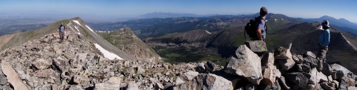
This pic was taken on the way down. (As usual, click on the pictures to bring up a larger version). Most hiked far off the right side of the picture. Our path had been straight to the ridge on the left. See the highest point on the ridge in the pic, now go to the left, half-way to the left of the picture. That's about where we hit the ridge and then followed it for the rest of the hike, coming from the bottom right of pic.
As we neared the ridge, Jon got some distance between us and after about 30 minutes I didn't see him anymore. He would later pass me when I was about 15-20 minutes from the summit. The old jeep track criss-crosses the left side of the face. It is very faint, and appears to to not have been used in decades. It would find me and leave me as I made my way to the point. It finally ended a couple hundred (?) feet from the top of the ridge.
From the top of the ridge point, you can see the rest of the route. Note: the true summit (with lots of snow pockets below) is beyond the false summit that you have to hike over while enroute. The other side of the grassy ridge I just climbed was very cliffy on the other side for it's full length. If it had been the OTHER ranch that allowed access, this mountain would not be an easy hike but a full on climb! I would have much rather have hiked up in that canyon. It appeared much more pretty, trees, a lake or two, a creek, varied terrain surrounded by peaks of various heights. Oh well. There are a couple good pics of this later in the report.
View of the ridge route leading from the ridge point to the giant ego-cairn.
Ego-Cairn, with marmot mascot. It seemed to beckon to the other hikers of the day who had taken varied routes, but most seemed to find themselves near here along their assent. I met up with Todd and Kimberly whom I had met the evening prior at the gate.
From the ego-cairn, the ridge hangs a left and after a brief descent, makes an upward trend that culminated with a false summit.
Nice views from the false summit
It's only about 15 minutes to the summit from here. Just before this where Jon passed up on his way back down.
On the summit, me wearing WAY too much hair for this time of the year.
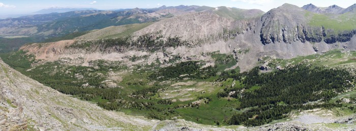
Summit panoshot with two hikers (Todd and Kimberly), Todd just arriving with the false summit behind him. I'll let you figure out how this in only two hikers. That cliffy point closest to the center of the pic is the point that I have been referring to as the "ridge point". You can see how it is surrounded on three sides by the deep canyon valley. The next two pics in the report will show the area below.
After being on the summit for 30 minutes, it was time to head down. I retraced my steps along the ridgeline to the ridge point and continued to follow the ridge all the way to the truck. I hiked solo for the entire hike back. It was a nice hike.
The view over the backside of the ridge. Culebra's summit is just to the right out of sight along the far horizon of peaks, behind the steep hillside on the right of the pic.
Again, viewing over the backside of the ridge and farther down the mountain toward the valley. You can see the Blanca group on the far upper left of the picture.
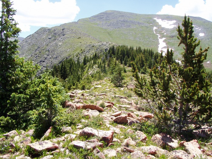
The ridge drops below treeline and is easy hiking though a loose forest of short trees.
The ridge continues to drop off cliffs to the left, I stayed within 20 feet of the edge most of the route
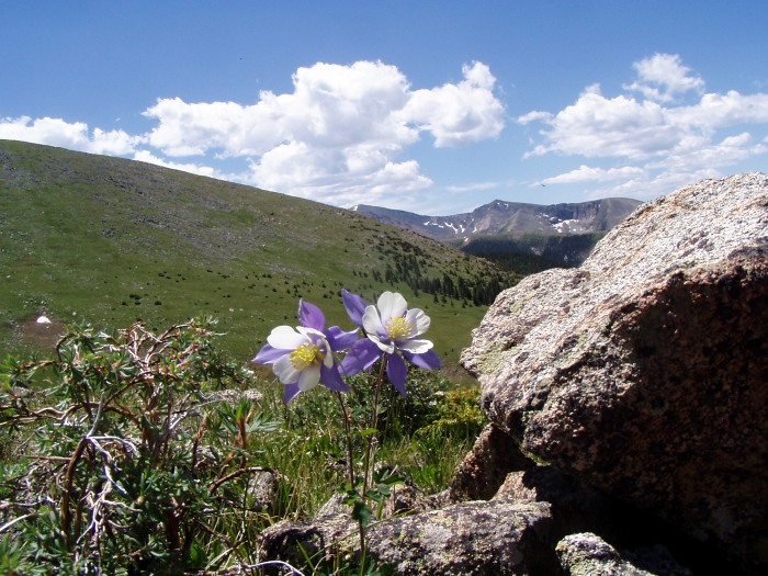
A few clusters of columbine along the way. This was an unexpected treat.
as I neared the "four way" parking, I discovered some faint double tracks that would not have been noticeable if not for the many pine cones that have come to rest in the slight depressions. Apparently the four-way was once a five-way?
I was led to believe that the $100 hike was worth it to see a 14er still in pristine condition. But I found some trash all the same: An old beer can, Coors to be exact. The older style pull-tab tells me that it has been here a LONG time. I packed it, out all the same.
I pop out of the forest as the ridge meets the parking area.
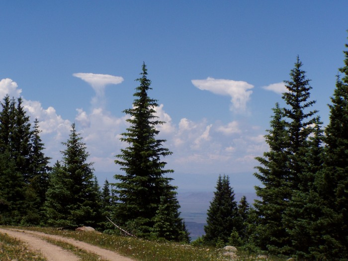
Some funky UFO cloud formations on the drive down the mountain.
And now, just for fun, lets see how it all adds up:
We camped at the gate (-$5) when the ranch could have easily designated a better camping area farther up into where the trees were. Just 1/4-acre of the 77,000 they have could suffice. (-$10)
They did provide a port-a-potty which I used twice (+$1), (+$2) and it was well stocked with toilet paper, nine rolls to be exact. (+$9)
The gate keeper, Carlos is a really nice guy, so that's worth a some bucks, (+$8)
The hike up the grassy hill is nice and you just pick your route, not having to worry about being bad for walking off trail. (+$25)
Hiking along the ridge provides great views of the basin below. (+$25)
There's a false summit. (-$0.01)
I summited. (+$25)
The hike back along the ridge though the forest next to the cliffs. (+$25)
I found an old beer can on a mountain that was billed as the most pristine 14er in the state. (-$5)
That all adds up to $99.99 Just short of the $100 fee. I guess they need to lower the price. Some one owes me a penny.
In conclusion: Although I will not pay another $100 fee for a return visit, I greatly enjoyed my entire day on the mountain.
Thumbnails for uploaded photos (click to open slideshow):
Nicely done post, good pix and liked the stitching on the two people /threesome shot. Liked the larger size images too thanx!
Having done all the 14ers and some numerous times I‘m gauled by the history of this $100 fee 14er. That makes me an ABC club ,...all but Culabra club member. Worst was when Pei outbid the state of Colorado with his ill gotten Enron money it‘s infuriating.
He no longer owns it but the whole thing just reeks. Of course the history of the ”Taylor Ranch” debacles goes back to the famous ”Buiebian document‘(sp?) Don‘t get me started!
Again much thanks, good write up and great story telling pix!
This report is a very good reference for what climbing Culebra is like. I was there the day before, and my experience with the ranch was nearly the same as you've described it!
Caution: The information contained in this report may not be accurate and should not be the only resource used in preparation for your climb. Failure to have the necessary experience, physical conditioning, supplies or equipment can result in injury or death. 14ers.com and the author(s) of this report provide no warranties, either express or implied, that the information provided is accurate or reliable. By using the information provided, you agree to indemnify and hold harmless 14ers.com and the report author(s) with respect to any claims and demands against them, including any attorney fees and expenses. Please read the 14ers.com Safety and Disclaimer pages for more information.
Please respect private property: 14ers.com supports the rights of private landowners to determine how and by whom their land will be used. In Colorado, it is your responsibility to determine if land is private and to obtain the appropriate permission before entering the property.


")


