| Report Type | Full |
| Peak(s) |
El Diente Peak - 14,175 feet |
| Date Posted | 07/09/2009 |
| Modified | 07/10/2009 |
| Date Climbed | 07/07/2009 |
| Author | Pappy |
| Precarious day on El Diente - North Slope |
|---|
|
Peak: El Diente (14,159 ft) Trailhead: Navajo Lake Route: North Slope Elevation Gain: 5,100 ft Total Mileage: 15 miles Difficulty: Class 3 7-6-09: Jake, Katie, and I left Vernal around 5:00 pm. We had intended on leaving much earlier, but as luck would have it, this didn't happen. At around midnight we reached the Navajo Lake trailhead. 7-7-09: By 1230 am we set out for Navajo Basin. We were already way behind our planned schedule. In the back of my mind I was thinking "we're supposed be starting the climb of El Diente in 2.5 hours so that we can be on the summit by sunrise, this is going to be a long day." Our plan was El Diente by sunrise, then the traverse to Mt. Wilson, and back to camp. Plenty of time....yeh right. The hike up the valley was incredible by full moon. At 3:00am I arrived at Navajo Lake and began looking for a place to camp knowing that Katie was acquiring blisters o' plenty and we were all tired after an extended day. Most of the good camping places were already taken, but did manage to find a relatively flat place to camp. At 3:45 we were all down for the count. After a couple of miserable hours trying to sleep on a lumpy slope I looked out of my bivy to see that sunlight was already hitting the top of El Diente (6:45). I thought "we should be up there already." At this point I was having an inner battle with myself..."I'm tired and feel like crap, yes but you have mountains to climb." The Carls Jr. $6.00 burger I had in Junction had not settled well, and my bowels were not happy. I'll leave it at that. At 7:30 Jake and I set off for El Diente. Katie had planed on staying in camp for marmot control. Upon reaching the top of Navajo Basin it looked like El Diente was just right there. We started up the rocky bottom of the North slope. Upon making to a very large boulder just below where the snow started (see 1st picture), an object went zipping by Jake and I. My first thought was "that bird's hauling butt." Then as several other objects went whipping by, we quickly realized we were targets of rocks hurling down the above snowfield. We had planned to ascend via the North Couloir making for a quicker ascent. With rocks already breaking free from above this quickly eliminated that option. The price paid for a late start. The rock outcrops became our route of choice with occasionally having to cross the snow. Our route up the north slope.  The rock on our route was fairly solid for the most part. A lot of quality bouldering with an occasional class 3 scramble. 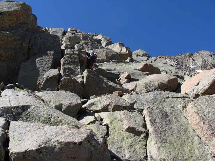 Picking our way through the rock was time consuming in a few places. View looking across at Wilson Peak and the Rock of Ages saddle. The north slope is definitely very steep.  Approaching the ridgeline between the Organ Pipe Gendarmes and El Diente, looking across towards El Diente. 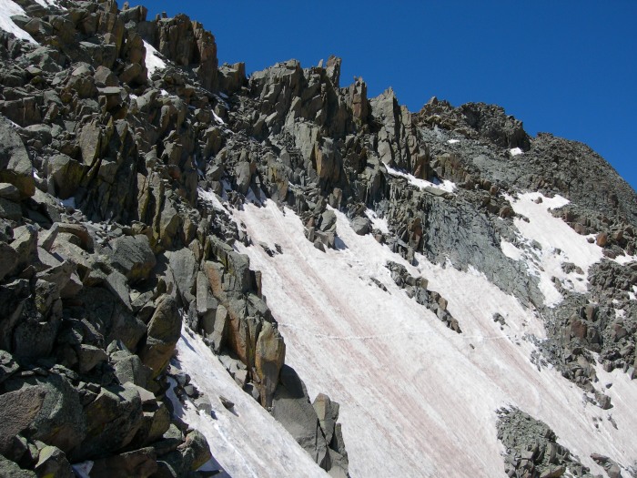 On our ascent there were ever so frequent bombardments of the north couloir and other snow fields around the basin by falling rocks and boulders. At times rocks would sweep the entire span of the couloir like cluster bombs. Sure glad we avoided the couloir. Ridgeline looking towards Mount Wilson through the "Organ Pipes."  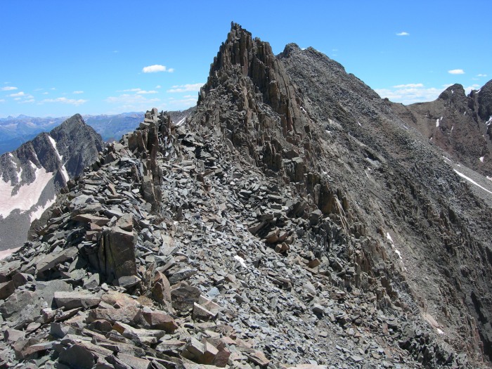 Once reaching the ridgeline we dropped over onto the south side of the slope and began to traverse over to El Diente. This stretch is pretty straight forward. Follow the occasional rock Carron. 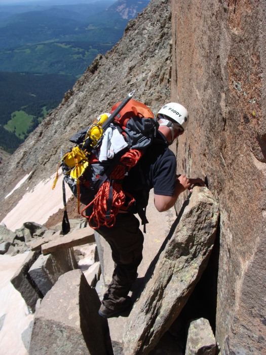 Eventually you will go up a rocky shoot that takes you back to the north side of the ridge. From here we stayed on the ridgeline for a short distance until we reached the summit block. Looking back to the east towards Mount Wilson. 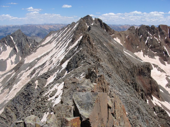  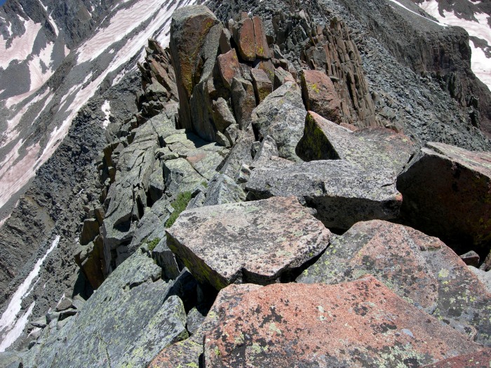 This is where things got interesting. The standard route follows what's in the picture below. The problem was the combination of soft snow, ice, loose scree, and sloping wet rock under it all. One little slip and you could be off into the abyss. It wasn't that it was a hard climb at all, just the mere chance of slipping. It would have been better if it were continuous snow/ ice, or just rock rubble. But the combination made using crampons awkward. We spent a fair amount of time, probably close to an hour, looking at all our options, alternative routes, and the like. A couple of gals we traversed the ridge with that came up from the Kilpacker side decided to go ahead and cross while we were scouting around. Jake and I decided it wasn't worth the risk without some sort of protection. Our plan of attack became a series of short belays and a pseudo rappel. In the middle of this stretch was a large protruding rock which became very useful.  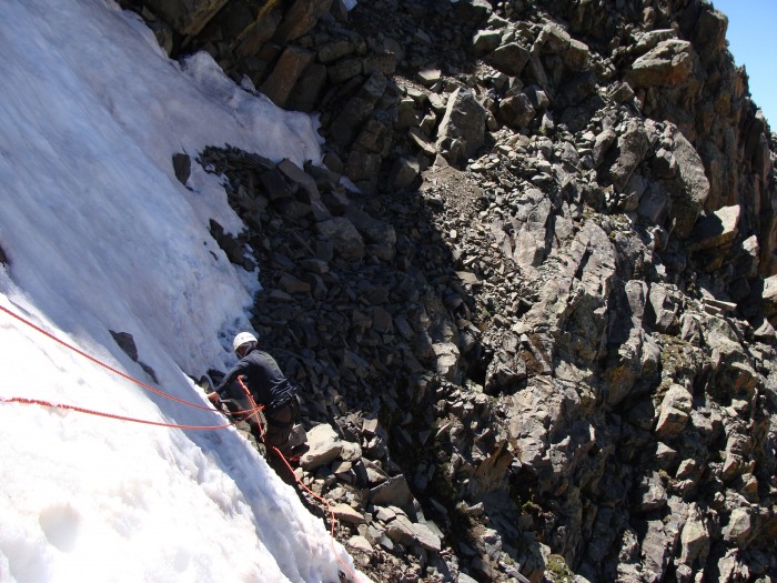 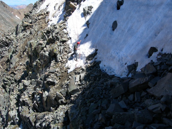 Having crossed this stretch in 3 short segments we thought we were in the clear. Not so much. Just above where way had to leave the rope behind there was another spot with great exposure that crossed a snow/ice shoot. There were foot tracks across it, however; some were slicked off and very icy. To negotiate this part we became very close and fond of a large rock which you could grip ever so tightly to get across. After crossing this little obstacle we went up through the notch. From the notch we took a short class 3 route straight up the rock to avoid yet another icy shoot off leading into the abyss to the right. At the top of this short climb was the east lower summit of El Diente. A short scramble takes you to the true summit at 14,159 ft. Summit of El Diente.  Looking back at Jake on the east summit.  Wilson peak (14,017 ft) from El Diente.  Mount Wilson (14,264 ft) and Gladstone Peak (13,913) on the left. 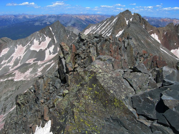 Jake signing the summit register.  Our route up to the east summit.   SIDE NOTE: I've read what I'm about to say numerous times from past TR's. For a 14er that doesn't count, this one is much harder than a vast majority of the ones that do. Even if the elevation difference between it and Mount Wilson doesn't exceed 300 ft, the traverse between the two ought to make up for that. End side note. Going back across the dicey spots.   Looking across at the traverse to Mount Wilson.  Once we returned back to this point on the ridge we had to make a hard decision. Do we continue with our original quest to do the traverse to Mount Wilson or do we call it a day. Things we considered: the weather couldn't have been better, we're way behind the clock, still 4-5 hours left of good light, I'd been running on empty all day, Jake had told Katie we'd be back in camp 6-8 hours from when we left, Wilson looks so close, and the real hard one....we really really wanted to continue. I still can't believe we conceded to this, but we aborted the rest of the quest and began our descent. We descended about 500 feet via rock before taking to the north couloir. We hadn't heard or seen any rockfall for about 1.5 hours. So we quickly glacaded down with one eye looking up ever so frequently watching for incoming rocks. The descent was definitely much quicker than the ascent. Once at the bottom, we casually hiked back down the basin to camp. The wildflowers in Navajo Basin are splendid right now. By the time we arrived back in camp my Mt House beef stroganoff was sounding delish. 7/8/09 What a good night sleep!! I felt human and revived. As we started up the hill out of Navajo Lake towards the trailhead I was thinking to myself "my inner chi is back, I feel great, Jake is soooo lucky I didn't wake up at 4:00 feeling like this. We would be climbing Mount Wilson right now." Navajo Lake.  Looking back up the valley through a sea of California Corn Lily.  On the way back I ran into a gal that was amazing. When I asked her if she was headed up to climb, her reply was "no I'm packing up beer to a group in the basin." Now that's what I call camp support!! Anyway... El Diente is an awesome peak....and it counts in my mind! Mount Wilson...We'll be back....again. Thumbnails for uploaded photos (click to open slideshow): ")
")
")
")
")
")
")
")
")
")
")
")
")
")
")
")
")
")
")
")
")
")
")
")
")
|
| Comments or Questions | |||||||||
|---|---|---|---|---|---|---|---|---|---|
|
Caution: The information contained in this report may not be accurate and should not be the only resource used in preparation for your climb. Failure to have the necessary experience, physical conditioning, supplies or equipment can result in injury or death. 14ers.com and the author(s) of this report provide no warranties, either express or implied, that the information provided is accurate or reliable. By using the information provided, you agree to indemnify and hold harmless 14ers.com and the report author(s) with respect to any claims and demands against them, including any attorney fees and expenses. Please read the 14ers.com Safety and Disclaimer pages for more information.
Please respect private property: 14ers.com supports the rights of private landowners to determine how and by whom their land will be used. In Colorado, it is your responsibility to determine if land is private and to obtain the appropriate permission before entering the property.


