Download Agreement, Release, and Acknowledgement of Risk:
You (the person requesting this file download) fully understand mountain climbing ("Activity") involves risks and dangers of serious bodily injury, including permanent disability, paralysis, and death ("Risks") and you fully accept and assume all such risks and all responsibility for losses, costs, and damages you incur as a result of your participation in this Activity.
You acknowledge that information in the file you have chosen to download may not be accurate and may contain errors. You agree to assume all risks when using this information and agree to release and discharge 14ers.com, 14ers Inc. and the author(s) of such information (collectively, the "Released Parties").
You hereby discharge the Released Parties from all damages, actions, claims and liabilities of any nature, specifically including, but not limited to, damages, actions, claims and liabilities arising from or related to the negligence of the Released Parties. You further agree to indemnify, hold harmless and defend 14ers.com, 14ers Inc. and each of the other Released Parties from and against any loss, damage, liability and expense, including costs and attorney fees, incurred by 14ers.com, 14ers Inc. or any of the other Released Parties as a result of you using information provided on the 14ers.com or 14ers Inc. websites.
You have read this agreement, fully understand its terms and intend it to be a complete and unconditional release of all liability to the greatest extent allowed by law and agree that if any portion of this agreement is held to be invalid the balance, notwithstanding, shall continue in full force and effect.
By clicking "OK" you agree to these terms. If you DO NOT agree, click "Cancel"...
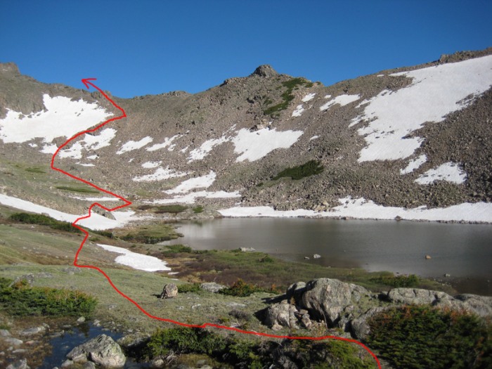
Location: Indian Peaks Wilderness, on the Continental Divide, 1 mile south of Mt. Neva
Trailhead: Fourth of July Trailhead
Route: Northeast Ridge
Round-trip Distance: about 7 miles (or more, depending on how much you meander in the woods and switchback up the snow)
Total Elevation Gain Estimate: around 3,200 feet
Preface: "Jasper" Peak (also known as Mount Jasper) is Point 12,923' on most maps. There's not a lot of beta out there on this mountain. The best source we could find was Gerry Roach's book, "Colorado's Indian Peaks: Classic Hikes and Climbs." It came in very handy, even though the Jasper description is brief. Some of Roach's numbers seem a little off, though. The total mileage seems too low (for one, it says it's only a half-mile to the Diamond Lake Trail junction, but it's really more than a mile) and the elevation gain doesn't account for the ups and downs (especially all the annoying gain on the return, from Middle Boulder Creek back to the junction).
After I got home from this climb I realized I had a second source that I didn't even know about: "Best Summit Hikes in Colorado," by James Dziezynski. This book has a more detailed route description, including GPS waypoints, but the last pitch is for the East Slopes (snow) route, not the Northeast Ridge (Class 3) route that we took.
Shortly after pulling into the Fourth of July Trailhead parking lot, a guy asked us what we were climbing. After we said Jasper, he said, "I've always wanted to do that one but I've heard it's hard to find." Those weren't the most encouraging words to hear while we were prepping our packs for the climb.
At 5:50 a.m. we started up the Arapaho Pass Trail, setting a pretty good pace. The sky was completely clear and the temperature was perfect - not too cold and not too hot.
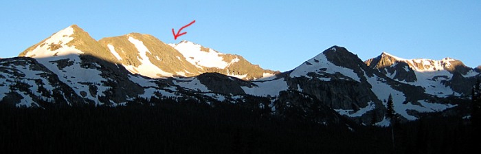
At one clearing we got our first glimpse of Jasper (actual summit is hidden just out of view):
The water was really flowing from the recent rain and melting snow.
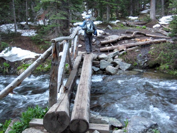
We could hear Middle Boulder Creek raging in the valley below, which made us wonder about the crossing we would soon have to make.
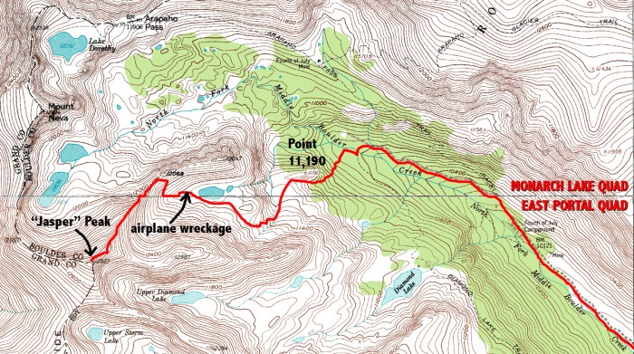
More than a mile up the trail, we left the Arapaho Pass Trail and got on the Diamond Lake Trail, which eventually descended down to Middle Boulder Creek.
Once at Middle Boulder Creek, we were happy to see a solid bridge, which just cleared the torrent.
After crossing Middle Boulder Creek, we immediately took a hard right (west) and followed a faint trail along the creek's southern shore, right past a loud waterfall.
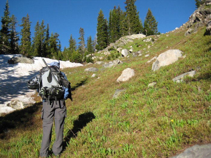
After about 100 yards or so, we came to a small clearing with swampy grass. We had to angle 100 feet or so to the left in order to find a halfway-dry area to cross this boggy area. From there we headed southwest (kept the compass in hand for this bushwhacking stretch) up a steep slope and through a dense forest.
Moments later we came to a small stream, which we both jumped across, and then we continued in a southwest direction using the stream as a "handrail" on our left.
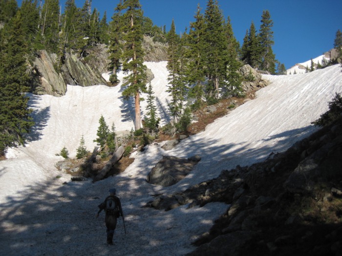
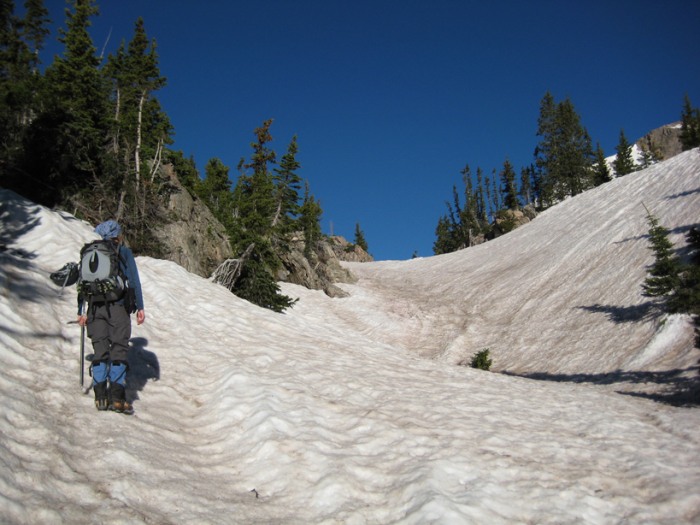
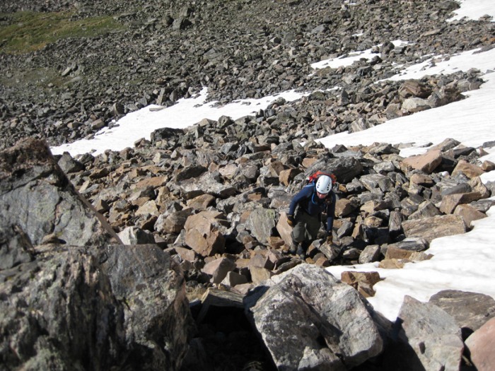
As we ascended, the slope went from soppy to snowy, and the gully we were in became narrower the higher we got.
We referred to the compass and the map often, and it took a little work to figure out exactly where we were. Eventually we located Point 11,190 (which I would describe as a rocky, tree-covered outcrop) that Roach mentions in his description, and we were happy to be on track.
We could hear a lot of water running under the low point of the snow, so we stuck to the sides as much as possible. Breaking through snow and falling into a stream of water wouldn't be fun.
At around 11,200' our route leveled out as we gained the lower basin. Snow still covered most of that area.
After dealing with some slight confusion as to what was what (at first, I thought I saw Jasper, but it was just another peak to its south, and Jasper was still out of view), we crossed the mostly snow-covered shelf of land and chose a route up one snow slope.
Earlier that morning we wondered what the snow was going to be like, but it ended up being great for cramponing.
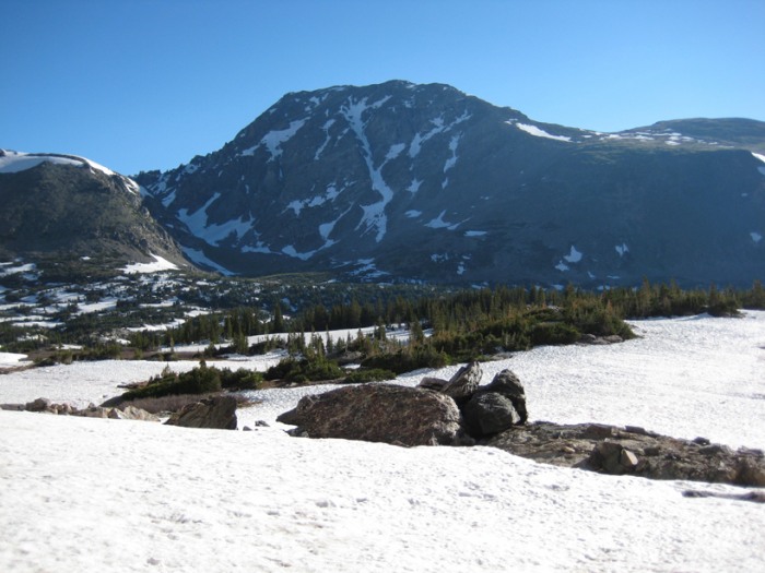
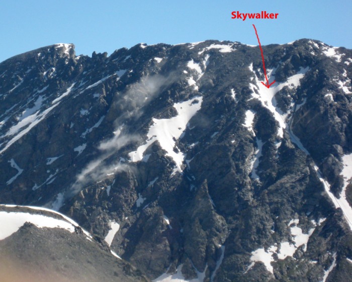
A look back at South Arapaho Peak (and Skywalker Couloir):
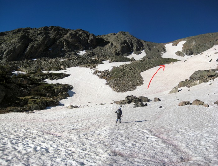
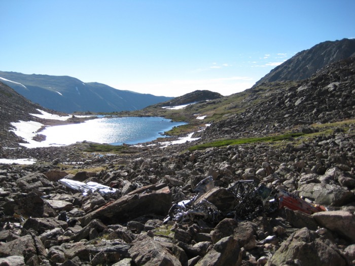
Once we gained the upper basin, we pushed on toward the unnamed alpine lake (as I learned later from Dziezynski's book, it's known as "Lake Xanadu") at 11,550'.
Just south of the lake we were afforded our first good view of Jasper, even though the true summit was still out of view.
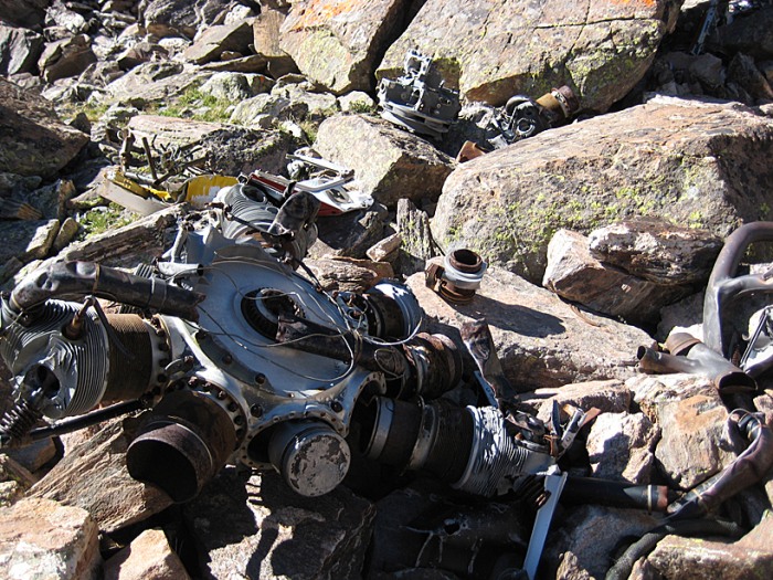
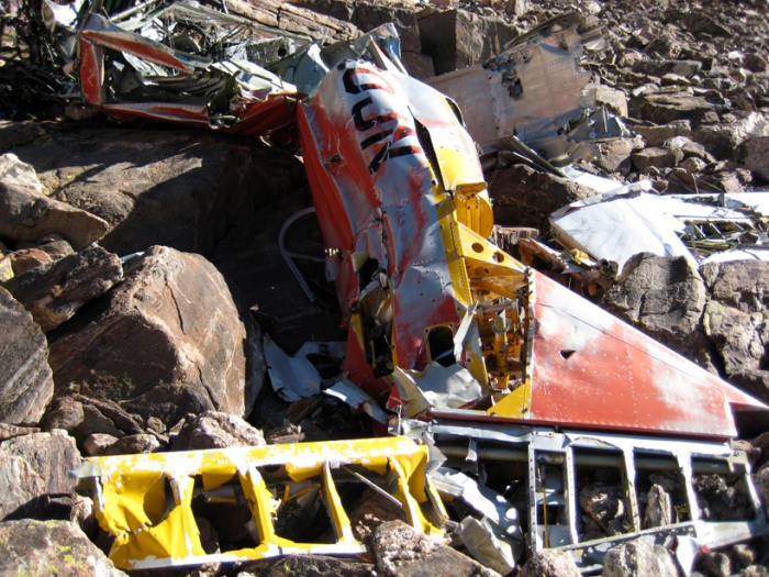
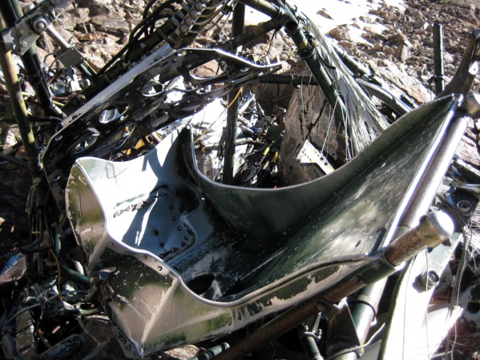
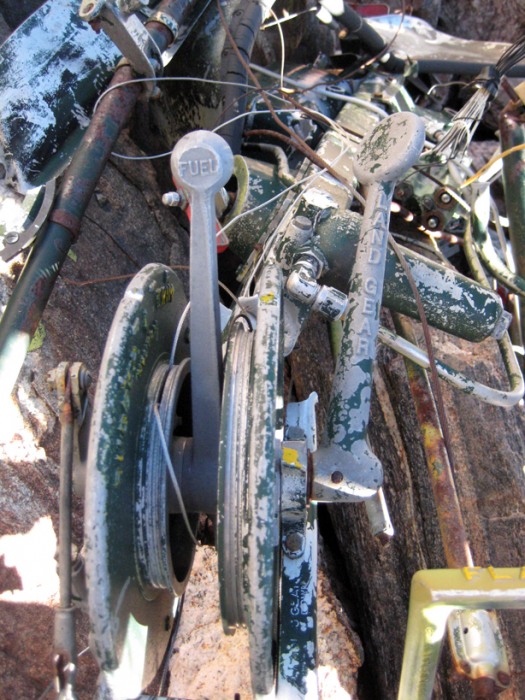
Because we can only leave our dogs home alone for so long, we worried that we wouldn't have enough time to make it up and back down in time. All that routefinding, bushwhacking and snow climbing took longer than we expected. But we decided to continue on and at least check out the airplane wreckage we read about.
The wreckage was really interesting. (I wasn't able to find any information on the Web about this crash. If anyone has any info, please post a comment at the end of this trip report.)
A look back at Lake Xanadu from the airplane wreckage:
The summit looked so far away. Probably because it was. We still had 1,200 feet to climb and three-fourths of a mile to go -- up a Class 3 ridge. We didn't think we could do it in time to be back home for our dogs. But we decided we'd have enough time to at least gain the ridge and check out the view.
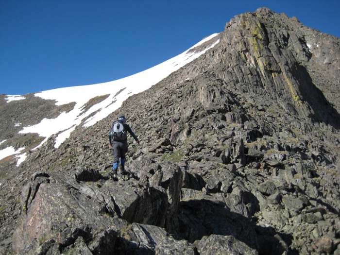
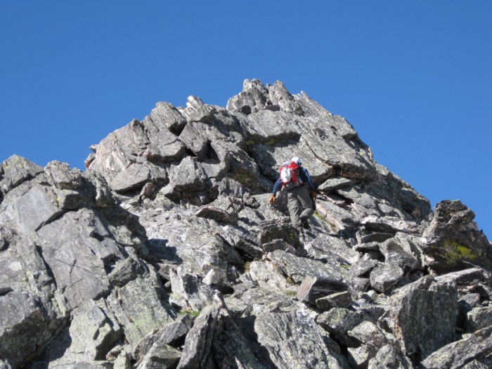
Since we made good time across the boulder field and up to the ridge, we decided to continue on, and just "see how things go."
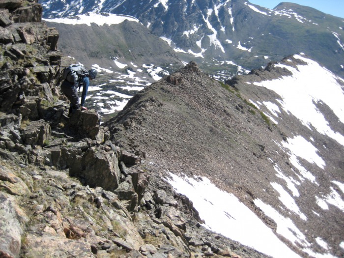
Fortunately, things went well, and the scrambling was a ton of fun on mostly solid and grippy rock. Some of the rock was sharp, so I was glad I brought my leather gloves.
Our route up the ridge, past Lake Xanadu:
Me boulder hopping up to the ridge:
When confronted with steep gendarmes, we easily traversed around the left (south), the less-exposed side. A few sections were a bit airy but exposure wasn't that bad, overall.
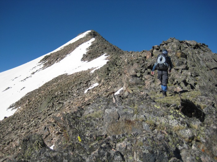
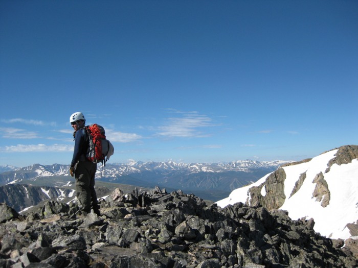
After passing a false summit I thought I had the true summit in my sights. Yes! We were going to make it in time, I thought. Our quick, lung-pumping pace got us up that half-mile-long ridge (from its low point above the lake) in no time.
But when I gained the top, I saw the true summit a good scramble away, which required some elevation loss and gain to get there, and then back.
Me on the disappointing false summit, with the true summit behind me (Winter Park ski area in the background):
"Let's haul ass and finish this," I said. And so we did.
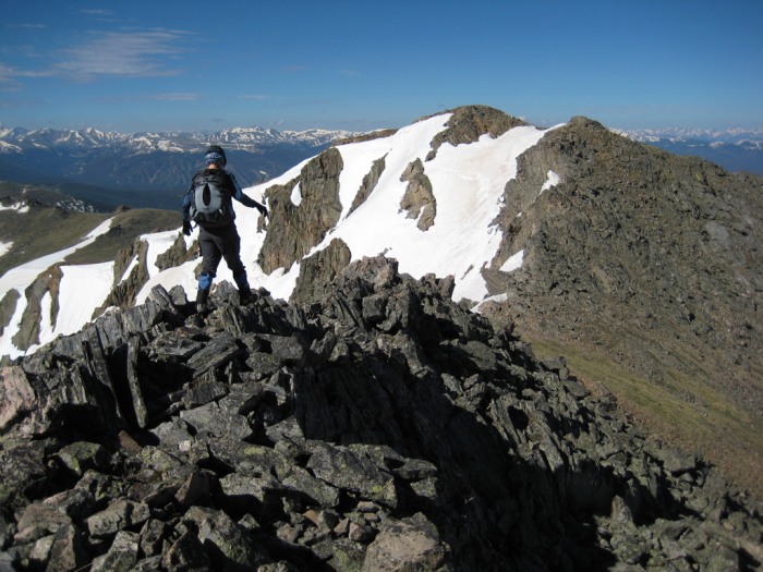
Jen on the false summit, setting off toward the true summit:
Just four minutes later, we gained the true summit.
What a tough 12er Jasper was. It took us three and a half hours to gain the summit - much longer than I expected.
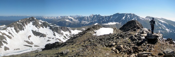
The summit offered an incredible view. And based on the number of people we saw on this mountain (none), I imagine it's not one that many see. Being such a rarely climbed peak, I was going to sign the register but I couldn't find it.
Summit panorama, best viewed full size (Left to Right: Mt. Neva, Arapaho Pass, heart of the Indian Peaks with Longs Peak way in the distance, North and South Arapaho Peaks; the dark hump just to the left of Jen is Jasper's false summit):
Going back down the ridge was just as fun as going up:
But our fun was interrupted by a loud, thunderous snow/rockslide emanating from across the valley, and it stopped us in our tracks. It appeared to be coming from a couple couloirs over from Skywalker (left/northwest of Skywalker), on South Arapaho Peak's southwest face.
Then, moments later, we heard an even louder crashing sound. This time we could see avalanche and rock debris billowing from the side of the mountain. We could even see a large boulder crashing down the mountain. It was difficult to determine just how large it was, but it was at least the size of a car, if not the size of an RV.
I tried to capture it on video but it's not the greatest. Check it out here (halfway through the video, look toward the bottom of the couloir and you can kind of see the mammoth rock crashing into snow):
Surprisingly, our descent only took us two hours, which was much quicker than our ascent. Not having to worry about routefinding as much plus the short glissades we made expedited things.
Once we made it back to Middle Boulder Creek and the Diamond Lake Trail, it was smooth sailing all the way back to the crowded parking lot.
Jasper turned out to be a really fun climb. It offers a good mix of terrain, views and challenges. It may just be a lowly 12er, but I thought it was tougher than some 14ers, and it's definitely worth the effort.
Here's a map of our route:
Thumbnails for uploaded photos (click to open slideshow):
I did a snow climb on Jasper on June 19 (see my TR), and a lot of snow has melted! Glad you were able to push on to the summit. Too bad I didn‘t post my gps map, the route is similar exept for the false summit approach
Very cool climb - I hope to do that one some day. The plane wreck aroused my curiosity, so I Googled the type of aircraft. The A-6 ”Texan” was mostly a trainer, but we see them in a lot of movies because they resemble a warbird. Here‘s a site with some images:
After Layne went south on the divide, I dropped off the northeast slopes of Jasper to an unnamed lake. I came across the debris of an old plane crash that didn't appear to be that old. I later found out that the pilot was a 29 year old commercial flight instructor flying from Denver to Steamboat Springs. He crashed on December 14, 1971 in bad weather. Anyway, the bushwhack back to the Diamond Lake Trail wasn't too bad, but somewhat interesting.
You might want to change the peak name to Mt Jasper in case anyone tries to search for it (as that is its popular/official name). The Snow Lion Couloir (as decribed in Dave Cooper's "Colorado Snow Climbs") was one of my favorite ski descents last year!
You nearly saw me up there on Sunday... 11/30/2010 5:28pm
Bergsteigen's earlier report, Roach's book, and the tragic allure of plane wreckage had put Jasper at the top of my list. But as I drove through Boulder at 5 AM I decided to head north to Brainard Lake and the Crooked Couloir of Mount Audubon.
Thanks for the fine trip report. Love the photos, story, topo. It will help me get up Jasper one weekend soon.
It's tough to drive hours to climb a 14er when there are so many fantastic (and sometimes solitary and just as exciting) peaks just a short drive away in the IPW.
While climbing Jasper's northeast ridge I noticed a newly placed benchmark, which was well below Jasper‘s summit. After doing research on the airplane wreckage, I stumbled across this article, and I imagine it has something to do with that benchmark (a link to a PDF with pictures is at the end of the text in this link):
Nice report. Looks like a beautiful climb. Did you know about the plane wreckage before you left? That would be pretty freaky.
Caution: The information contained in this report may not be accurate and should not be the only resource used in preparation for your climb. Failure to have the necessary experience, physical conditioning, supplies or equipment can result in injury or death. 14ers.com and the author(s) of this report provide no warranties, either express or implied, that the information provided is accurate or reliable. By using the information provided, you agree to indemnify and hold harmless 14ers.com and the report author(s) with respect to any claims and demands against them, including any attorney fees and expenses. Please read the 14ers.com Safety and Disclaimer pages for more information.
Please respect private property: 14ers.com supports the rights of private landowners to determine how and by whom their land will be used. In Colorado, it is your responsibility to determine if land is private and to obtain the appropriate permission before entering the property.