Download Agreement, Release, and Acknowledgement of Risk:
You (the person requesting this file download) fully understand mountain climbing ("Activity") involves risks and dangers of serious bodily injury, including permanent disability, paralysis, and death ("Risks") and you fully accept and assume all such risks and all responsibility for losses, costs, and damages you incur as a result of your participation in this Activity.
You acknowledge that information in the file you have chosen to download may not be accurate and may contain errors. You agree to assume all risks when using this information and agree to release and discharge 14ers.com, 14ers Inc. and the author(s) of such information (collectively, the "Released Parties").
You hereby discharge the Released Parties from all damages, actions, claims and liabilities of any nature, specifically including, but not limited to, damages, actions, claims and liabilities arising from or related to the negligence of the Released Parties. You further agree to indemnify, hold harmless and defend 14ers.com, 14ers Inc. and each of the other Released Parties from and against any loss, damage, liability and expense, including costs and attorney fees, incurred by 14ers.com, 14ers Inc. or any of the other Released Parties as a result of you using information provided on the 14ers.com or 14ers Inc. websites.
You have read this agreement, fully understand its terms and intend it to be a complete and unconditional release of all liability to the greatest extent allowed by law and agree that if any portion of this agreement is held to be invalid the balance, notwithstanding, shall continue in full force and effect.
By clicking "OK" you agree to these terms. If you DO NOT agree, click "Cancel"...
North Ridge (Standard Route - Class 2 - South Winfield TH)
Depart 4WD Trailhead: approx. 5:00 a.m.
Summit: approx. 8:30 a.m.
Return to Trailhead: approx. 10:45 a.m.
Total Elevation gain: approx. 3600 feet
Roundtrip mileage: approx. 7.5 miles
Since I had spent most of the week attending a mortgage fraud conference in Denver, I could not return home to Kansas City without trying to sneak in a peak. The plan was simple: leave Denver late in the afternoon on Thursday, drive to the South Winfield trailhead, get as far up the 4WD road as possible with the rental car, get some sleep, and take a shot at Huron early on Friday knowing I had to get back for an 8:30 p.m. flight out of DIA.
Got out of downtown Denver with the rental car as planned late Thursday afternoon and headed west on I-70; took the Hwy 91 exit to Leadville, kept going south on U.S. Hwy 24 to Clear Creek Reservoir and then down Chaffee County 390 to Winfield and the start of the 4WD road. There are numerous established campsites all along the length of the 4WD road, and I pulled into one after about a mile when I decided I had pressed my luck far enough in the FWD Chrysler Aspen SUV. Got my gear organized in the remaining daylight. There was plenty of room to comfortably spread out my 6' 1" frame with the seats folded down, so it was off to sleep in the back of the rental car right after snapping this picture in the last light of the day. This is what rental cars with less than 10,000 miles on them were made to do.
It had rained on me pretty much the entire drive from Denver, ranging between a drizzle to a steady downpour. I went to sleep listening to light rain, hoping for a clearing sky in the morning. The weather would have to cooperate if my plan to sneak in a peak was going to succeed. I could see a star or two in the sky when I woke up around 1:00 a.m. and I was encouraged when there were quite a few more as I started walking up the road toward the Huron Peak trailhead around 4:15 a.m. Maybe the rain would hold off after all. I unknowingly went up the Banker Mine road in the dark but quickly realized my mistake when I came upon the old mine buildings. No mention of those in Bill's directions to the trailhead! Even with this detour, it was a little before 5:00 a.m. when I finally headed up the Huron Peak trail.
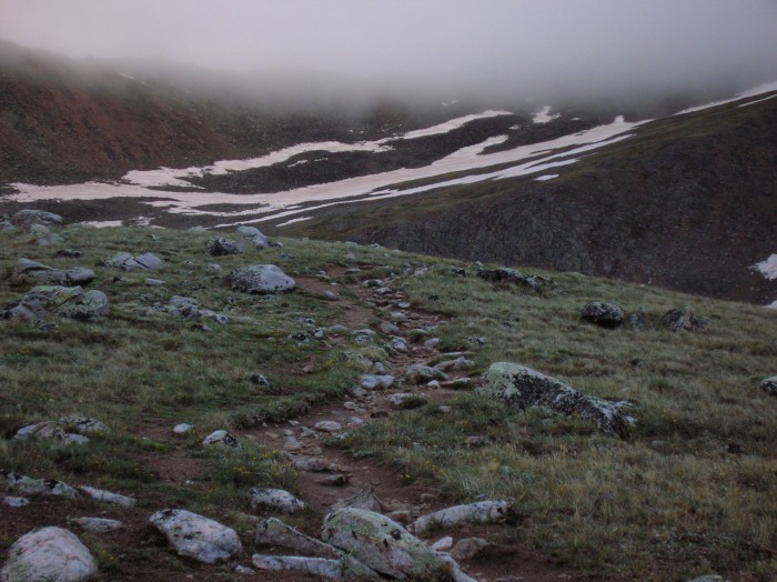
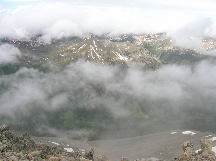
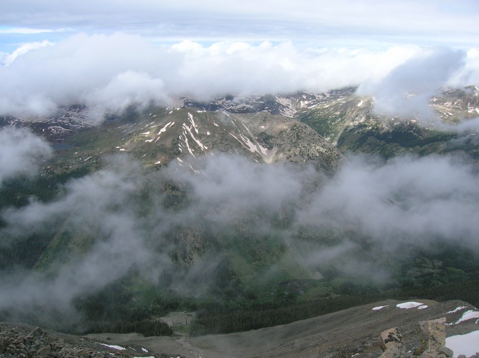
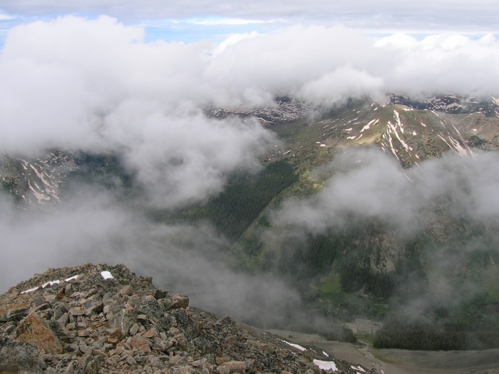
Within a half hour after signing in at the trail register, there was enough light to easily navigate on the well-defined CFI trail without the headlamp. As daylight increased, I could not get a good read on the sky but now, as the next picture shows, there was abundant low cloud cover.
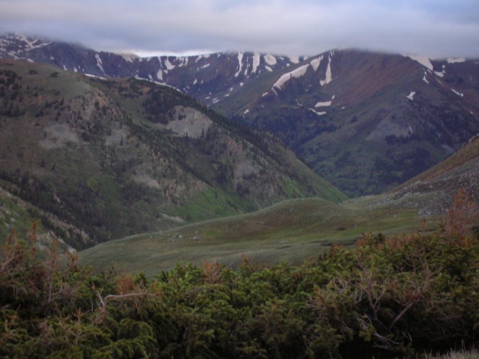
Hoping to see the much publicized view of the Three Apostles from the trail, I was disappointed. They were there all right, but the tops of the peaks were obscured by clouds, with no view of their full grandeur. After breaking treeline and entering the basin, the low cloud cover continued to be obvious, persistent, and potentially ominous.
Heading up out of the basin, the Three Apostles were still hidden from view, along with practically everything else.
Especially after breaking treeline, I was constantly considering whether to press on or turn around. But the rain never started and, more importantly, there was no indication of typical rain cloud buildup.
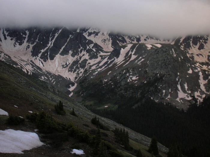
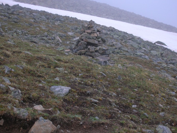
This large cairn, located part way up the great trail to the ridge crest, shows again how low the cloud cover was, and I was walking right into the thick of it the higher I went.
I kept wondering if I was going to get caught by any kind of storm and was ready to bolt and run at the first sign of any kind of weather trouble.
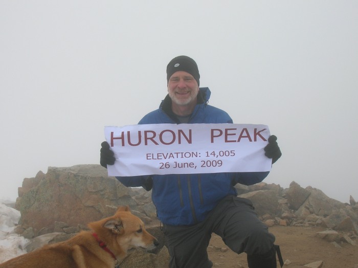
I pressed on up the switchbacks to the ridge, and knew when I gained the ridge it was just another 550 feet of elevation gain to the summit. Energized by that awareness, it seemed like I was on the summit in no time. I was the first to summit and my reward - for being alone on the top of a peak reported to have some of the best views in the Sawatch - was to see absolutely nothing. A solo climber from Colorado Springs arrived about 15 minutes later with his dog, and we took turns taking summit shots of each other with a banner that my friend Sarge, a 14ers.com member, made for me. The dog was exceptionally friendly, so I included him in my shot and paid him with a hunk of cheese. Forgot to ask his name, but doesn't he look a little bit like a red fox?
In about 10 minutes we were joined by Matthew Hayden from Breckenridge, who said he had left his camera behind. I took a shot of him with Sarge's banner so I could email it to him.
Both summit shots show the denseness of the low cloud cover. The snow Matthew is standing in on the summit was about the only place we encountered it. The trail itself was almost entirely snow free, with only a couple of short trail sections in the basin still being snow covered.
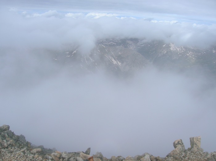
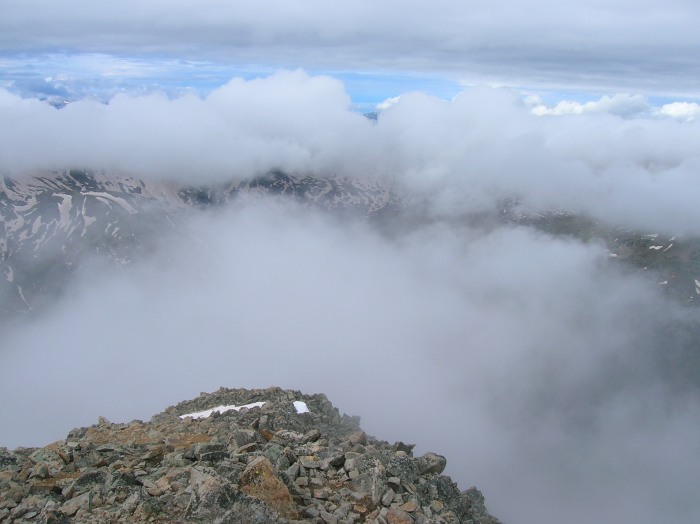
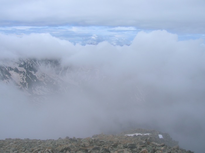
After about a half hour on the summit, I figured the cloud cover was not going to relent and I was ready to head down. The famed Huron summit views would have to wait for another day. Just as I reached for my pack, there was a momentary cloud break to the west, so I quickly found the camera and snapped these shots. There was never a view in any other direction, and this was as good as it was going to get for today. Not much from the standpoint of eye popping views, but they do capture the ethereal nature of the clouds.
If I am correct, and this is indeed a westerly view, then I think the partially visible peak in these shots is Granite Mountain. Perhaps someone more familiar with the peak will know for sure.
Exhilarated to have gotten these limited views when it had looked like none were to be had, I quickly headed down to the trailhead, wanting to make sure I had plenty of time to get back to Denver and catch my plane home. When I got to the basin, the clouds had cleared to the point I could look up and see Huron's summit, a view that had been kept from me on the ascent. It sure looked a long ways off, and I was kinda glad Huron had been shy during the ascent. It's all psychological no doubt, but somehow it seems easier for me to keep pressing on when I can't see how far off the summit is. The descent was quick and otherwise uneventful but it was mildly depressing to get to the end of the trail, knowing I had another mile to walk down the 4WD road to reach the car, but I was in the car and moving down the road by 11:30. Before I got to the Missouri Gulch trailhead, the rain started and continued all the way to Denver. Mission accomplished - snuck in a peak and stayed dry in the process. Poached a spit/sponge bath in the bathroom at the car rental place, and still got through security and to the gate about an hour and a half before scheduled departure. Even though Huron was very shy and did not reveal much of herself on this day, it was a good day in the mountains and a great way to end the work week.
Thumbnails for uploaded photos (click to open slideshow):
Why Did He Chicken Out on the Road? 6/28/2009 4:14am
Chris - the road was definitely doable in any decent clearance 4WD vehicle. I never bottomed out the rental car, but the road seemed to narrow and I was getting increasingly uncomfortable negotiating around the boulders in the road. Plus, it had been raining all afternoon and the track was getting slippery. Sliding the rental car off the road while manuvering around a boulder or avoiding someone coming from the other direction just did not seem worth the risk anymore, especially since daylight was fading and I had pushed the FWD further than I had expected it to go. Long story short - I would have kept going with the benefit of a 4WD vehicle I was familiar with. There was an Izuzu Trooper, a Ford Expedition with running boards, and a Ford Explorer at the end of the 4WD road when I walked out. So I don‘t think clearance should be an issue if you know what you are doing in a 4WD vehicle. But with the small window of time I had to squeeze in a peak, there was no margin to deal with car complications, so it just made sense to stop when I did. Hope that helps. Gene
There is something mentally draining about seeing a summit so far away knowing you will be up there. But on the way down it is cool to look up and say, ”yeah, I was up there,”.
Gene
Thanks for sharing another great trip report. You are touching a lot of summits for a flatlander! Do you have plans for any others between now and the end of July? BTW - reading your TR from Minneapolis visiting family and getting ready to check out their REI for boots, thanks for the suggestion. I may not be confirmed for the July climb but I'm definitely preparing for it.
Sorry you didn't get the view you'd hope for, but happy for you that you were dry and safe.
See you soon
John a.k.a. Subway
Thanks for a thorough trip report.
I have a 4WD vehicle, but not very good ground clearance.
I‘m concerned about the 4WD road that you mentioned going up and coming down. Did you stop short of the trailhead due to clearance concerns, or was it something else?
Please tell me whatever you can remember about the 4WD road.
Thanks in advance.
Chris
Caution: The information contained in this report may not be accurate and should not be the only resource used in preparation for your climb. Failure to have the necessary experience, physical conditioning, supplies or equipment can result in injury or death. 14ers.com and the author(s) of this report provide no warranties, either express or implied, that the information provided is accurate or reliable. By using the information provided, you agree to indemnify and hold harmless 14ers.com and the report author(s) with respect to any claims and demands against them, including any attorney fees and expenses. Please read the 14ers.com Safety and Disclaimer pages for more information.
Please respect private property: 14ers.com supports the rights of private landowners to determine how and by whom their land will be used. In Colorado, it is your responsibility to determine if land is private and to obtain the appropriate permission before entering the property.