Download Agreement, Release, and Acknowledgement of Risk:
You (the person requesting this file download) fully understand mountain climbing ("Activity") involves risks and dangers of serious bodily injury, including permanent disability, paralysis, and death ("Risks") and you fully accept and assume all such risks and all responsibility for losses, costs, and damages you incur as a result of your participation in this Activity.
You acknowledge that information in the file you have chosen to download may not be accurate and may contain errors. You agree to assume all risks when using this information and agree to release and discharge 14ers.com, 14ers Inc. and the author(s) of such information (collectively, the "Released Parties").
You hereby discharge the Released Parties from all damages, actions, claims and liabilities of any nature, specifically including, but not limited to, damages, actions, claims and liabilities arising from or related to the negligence of the Released Parties. You further agree to indemnify, hold harmless and defend 14ers.com, 14ers Inc. and each of the other Released Parties from and against any loss, damage, liability and expense, including costs and attorney fees, incurred by 14ers.com, 14ers Inc. or any of the other Released Parties as a result of you using information provided on the 14ers.com or 14ers Inc. websites.
You have read this agreement, fully understand its terms and intend it to be a complete and unconditional release of all liability to the greatest extent allowed by law and agree that if any portion of this agreement is held to be invalid the balance, notwithstanding, shall continue in full force and effect.
By clicking "OK" you agree to these terms. If you DO NOT agree, click "Cancel"...
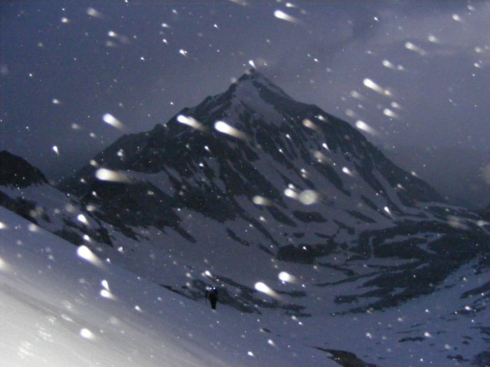
I met themuffinknight, Nick, at Twin Lakes and we headed over Independence Pass. Luckily we realized neither of us had a watch for the wake-up call in the morning before heading up Capitol Creek road. We had to run to Basalt to find a store that carried this necessity. So after a short delay, we headed back up the road. We arrived at the TH and our first sight of Capitol.
We loaded ourselves down and headed out about 1230. The trail was easy going and we easily found the crossing at the creek (thanks maverick_manely). It‘s a great log with a handrail to boot about 150‘ upstream from where the trail crosses. We soon entered the trees and started the first of two snow sections. This one went fairly quickly as we followed tracks through the woods. Another bit of trail landed us in snow for basically the remainder of the trip. We followed the tracks until we were led into a draw and across the stream. We made our way cross country up some steeper slopes, side-hilled and finally made the campsites when we found the trail again. We setup on a perfect level spot just behind site 2, and took in the views of tomorrow‘s challenge
and a preview of the knife-edge.
At 0230 the watch did its job and started the day. We were on the trail at 0330 heading to the saddle. The slope was mostly snow free and we were able to follow the trail most of the way with a short snow crossing near the top. We donned crampons before starting the unexpectedly long traverse around the basin to K2.
Nick led the charge up K2.
We took stock of our options
and started off at 0630. We foolishly went due west off K2 and down the snowy slabs. 40‘ of tenuous down climbing brought us to the start of the ridge. We had to make a couple moves to pass a small chimney. We found ourselves at the supposed crux.
All the fresh had fallen since we left the saddle.
Nick standing tall!
I had to get shots of the neighbors when I had the chance.
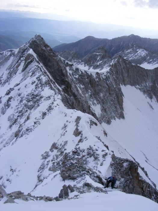
The rest of the ridge went quickly as we stayed on snow on or near the crest. We started to gain elevation again as we moved up the shoulder.
It looks so close
We started the traverse out to the gully on climbers left and found a few cairns on the way. The snow was very firm and I found myself swinging my axe primarily.
We found the gully a little steeper than I had thought. I‘m guessing it went to about 60-65 degrees.
Nick opted to work the rock on the side of the gully and we met to finish it out. The angle eased and we moved through the last small section to the summit ridge.
#59, the victory shot at 0830
and themuffinknight‘s standard summit shot
A look down the face to the lake
But victory had to wait until the descent was complete. We retraced our steps. I tried the rock on the side of the gully for descent. It had a couple funky moves that threw me off a bit, but it went.
We crossed back to the ridge and headed for the exit.
The knife-edge had blown clear once more and I had to show off a little.
We were happy to be by the knife-edge but still had to pass the chimney and K2. We almost forgot about that little chimney, but we remembered the moves and went right through. This time we traversed below the slabs on K2. Nick went to the summit and I traversed a little bowl to the next ridge. I got to the ridge to realize I was still one off. So I headed to the top of K2 as well and then dropped off from there at 1030. We made good time as we headed for the saddle.
After this picture the snow started to turn to shit. The side-hilling got worse than usual as every step tried to slip downhill. I even lost it once and went sliding away. We worked through the last off it to the saddle and dropped the crampons. We quickly dropped down to camp as the sun shone. At 1230 we started to pack up and the snow roared in. The tent had to be packed with the snow that fell on it as we rolled it up. We headed out and tried to follow the other tracks. It went well until the tracks split up and every way lead nowhere. We backtracked to the creek and headed for our tracks from the way up. We got a little glissade back to the creek and followed our old track to through the snow. Right after we exited the trees and the snow we met a large group headed for the lake to camp. I doubt they made it in their sandals. The hike out was uneventful and we got back to the truck just before 1730.
That‘s it, the last of the 59 list. Thanks to all of you who joined me on this quest. See you next weekend!
Thumbnails for uploaded photos (click to open slideshow):
Man I know exactly how it feels to finish on that mountain, although you guys had waaay more challenging conditions than I did. Did you do the obligatory 5 minute yodel :D? Congratulations on the finish! Glad you found the log bridge.
Way to finish Andy! You are an animal! Congratulations on #59! Truly it was an honor to climb this with you.
Caution: The information contained in this report may not be accurate and should not be the only resource used in preparation for your climb. Failure to have the necessary experience, physical conditioning, supplies or equipment can result in injury or death. 14ers.com and the author(s) of this report provide no warranties, either express or implied, that the information provided is accurate or reliable. By using the information provided, you agree to indemnify and hold harmless 14ers.com and the report author(s) with respect to any claims and demands against them, including any attorney fees and expenses. Please read the 14ers.com Safety and Disclaimer pages for more information.
Please respect private property: 14ers.com supports the rights of private landowners to determine how and by whom their land will be used. In Colorado, it is your responsibility to determine if land is private and to obtain the appropriate permission before entering the property.


")
")
")
")
")
")
")
")
")
")
")
")
")
")
")
")
")
")
")
")
")
")
")
")


