Download Agreement, Release, and Acknowledgement of Risk:
You (the person requesting this file download) fully understand mountain climbing ("Activity") involves risks and dangers of serious bodily injury, including permanent disability, paralysis, and death ("Risks") and you fully accept and assume all such risks and all responsibility for losses, costs, and damages you incur as a result of your participation in this Activity.
You acknowledge that information in the file you have chosen to download may not be accurate and may contain errors. You agree to assume all risks when using this information and agree to release and discharge 14ers.com, 14ers Inc. and the author(s) of such information (collectively, the "Released Parties").
You hereby discharge the Released Parties from all damages, actions, claims and liabilities of any nature, specifically including, but not limited to, damages, actions, claims and liabilities arising from or related to the negligence of the Released Parties. You further agree to indemnify, hold harmless and defend 14ers.com, 14ers Inc. and each of the other Released Parties from and against any loss, damage, liability and expense, including costs and attorney fees, incurred by 14ers.com, 14ers Inc. or any of the other Released Parties as a result of you using information provided on the 14ers.com or 14ers Inc. websites.
You have read this agreement, fully understand its terms and intend it to be a complete and unconditional release of all liability to the greatest extent allowed by law and agree that if any portion of this agreement is held to be invalid the balance, notwithstanding, shall continue in full force and effect.
By clicking "OK" you agree to these terms. If you DO NOT agree, click "Cancel"...
| Report Type |
Full |
| Peak(s) |
Mount Garfield - 10920
|
| Date Posted |
05/31/2009 |
| Date Climbed |
05/31/2009 |
| Author |
dcbates80911 |
| It was about time for me to get out.... |
Garfield - 10,920
Partners - None
Distance ~ 9 miles
Elevation Gain ~ 3200 ft
OK...I have been inactive on this site and in the mountains. Frankly, this has been a very disappointing climbing year. I started a major work project on January 2nd (one day after summitting Pikes Peak) and it has been non-stop until about two weeks ago. There were some breaks, but I decided to spend time with my family instead of climbing (Favorite was skiing with my kids at Copper). This doesn't mean I didn't try. A group of us tried Sherman in February. A mountain I have done a couple times, but this time was different. 14-hour days just killed my stamina and I stopped at 13,100. At the time it didn't bother me, but now it does. Now, I am somewhat free with an extra 15 pounds (it is amazing what stress, long times behind a computer, and food can do). Today was welcomed.
Mount Garfield and Arthur are named after two presidents from around the time Colorado became a state. I have done both mountains a couple times. From Colorado Springs, they look like two twin bumps just south of Pikes Peak. The hike isn't easy. There are several approaches, but today I had to settle with using Seven Bridges trail off the close portion of Gold Camp Road. This is a nice trail for families to try as it follows Cheyenne Creek back towards Jones Park, one of my favorite areas near the Springs. There are several trail junctions in Jones Park, but I took the one that took me to the cabin ruins.

North Cheyenne Creek


Looking Back at Colorado Springs

Heading to Jones Park

Jones Park - Aspen are very pretty in the fall

Louds Cabin

From here (Louds Cabin), a trail heads NNW and follows the drainage. There are small cairns, but otherwise there is no real trail to follow. This part is tough as you climb over downed trees and many rocks up a fairly steep slope. The drainage is fairly tight with a lot of tree cover. My goal was a saddle at 10,499 feet where I would approach Garfield to the West and Arthur to the East. I decided to go a little more North and approach Garfield on a gentler slope, which wasn't bad.
Mount Rosa from the drainage

This is the crap you deal with west of the Springs

Upon reaching the summit there was a surprise waiting for me. Up the valley, I could see blue sky directly overhead. However, from the summit there were T-storms forming to the west. I turned on my NOAA radio and watched the clouds as I took pictures. Not sure Arthur would be made. Didn't see lighting, but the clouds were building quickly. I figured I could descend to the saddle and make a choice then, which I did. As I hit the saddle, there was a big BOOM. It was time to head home.
What the hell is this??? Dark clouds!!!

If you listen closely, you can hear NOAA weather on my radio as I try to figure out what is happening.
Pikes Peak

Cameron's Cone...I have to get this one.......

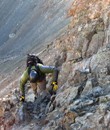
Self shot with my extra weight and Pikes Peak

In the drainage and down Seven Bridges, I was mostly in the rain. Not a bad thing as it is something I enjoy. I knew this project would be disruptive, but not to this point. It is nice to be back in the mountains and now it is time to loose the "project" weight and hit some 14ers.
|
Caution: The information contained in this report may not be accurate and should not be the only resource used in preparation for your climb. Failure to have the necessary experience, physical conditioning, supplies or equipment can result in injury or death. 14ers.com and the author(s) of this report provide no warranties, either express or implied, that the information provided is accurate or reliable. By using the information provided, you agree to indemnify and hold harmless 14ers.com and the report author(s) with respect to any claims and demands against them, including any attorney fees and expenses. Please read the 14ers.com Safety and Disclaimer pages for more information.
Please respect private property: 14ers.com supports the rights of private landowners to determine how and by whom their land will be used. In Colorado, it is your responsibility to determine if land is private and to obtain the appropriate permission before entering the property.