Download Agreement, Release, and Acknowledgement of Risk:
You (the person requesting this file download) fully understand mountain climbing ("Activity") involves risks and dangers of serious bodily injury, including permanent disability, paralysis, and death ("Risks") and you fully accept and assume all such risks and all responsibility for losses, costs, and damages you incur as a result of your participation in this Activity.
You acknowledge that information in the file you have chosen to download may not be accurate and may contain errors. You agree to assume all risks when using this information and agree to release and discharge 14ers.com, 14ers Inc. and the author(s) of such information (collectively, the "Released Parties").
You hereby discharge the Released Parties from all damages, actions, claims and liabilities of any nature, specifically including, but not limited to, damages, actions, claims and liabilities arising from or related to the negligence of the Released Parties. You further agree to indemnify, hold harmless and defend 14ers.com, 14ers Inc. and each of the other Released Parties from and against any loss, damage, liability and expense, including costs and attorney fees, incurred by 14ers.com, 14ers Inc. or any of the other Released Parties as a result of you using information provided on the 14ers.com or 14ers Inc. websites.
You have read this agreement, fully understand its terms and intend it to be a complete and unconditional release of all liability to the greatest extent allowed by law and agree that if any portion of this agreement is held to be invalid the balance, notwithstanding, shall continue in full force and effect.
By clicking "OK" you agree to these terms. If you DO NOT agree, click "Cancel"...
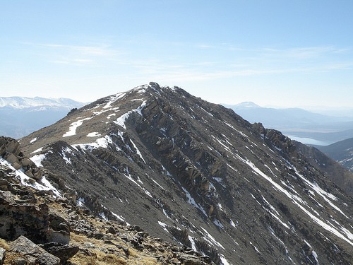
Mt. Massive seen from Leadville the afternoon before we climbed it
On Sunday May 17, blues311 and I climbed Mt. Massive via the SW Slopes route. Snow conditions were surprisingly good. We had numerous small snow crossings, but much of the route was melted out due to the southerly aspect and there was only one big snow climb, and with an ice ax and crampons it's an easy and safe climb. The trail was tough to follow at times, usually due to snow crossings, but we just kept scrambling up whenever we lost it, and usually we found it again pretty quickly since it switchbacks a lot.
We both arrived at the North Halfmoon Creek Trailhead on Saturday evening and camped at the trailhead. The road to the trailhead was not a problem for 4WD most of the way, and a strong 2WD could probably make it to the standard (East Slopes) Mt. Massive Trailhead. However, maybe a quarter mile from the TH, there was a really sketchy part of the road that involved driving over a slickrock with a big dip at the top, and then a sharp turn to the right, with a big dropoff into raging Halfmoon Creek on the left. Driving this part made me really nervous, even with 4WD, and since it's only about a 5 minute walk from the trailhead, I would recommend parking before that point unless you're just a badass on the 4WD.
The rough section of road near the trailhead - it's worse than it looks in this picture
We set our alarms for 3:45 a.m. on Sunday morning, and after eating a couple of PBJs for breakfast and packing up, we were on the trail by about 4:15 with the temperature about 26 degrees. The first mile and a half or so before the turnoff was on an easy trail, though it was quite muddy with all the snowmelt, but that wasn't really a big deal. There were several patches of rotten snow that we had to posthole through, but they were all short-lived and I'm guessing they'll be melting away soon.
At first we planned to take the West Slopes route, but after passing the trail junction for the SW Slopes route, we immediately lost the trail in deep and rotten snow and quickly decided to turn back and try the SW Slopes instead, which ended up being a very wise choice. Around this time we were treated to a spectacular sunrise.
First light over the surrounding Sawatch peaks (help me out and tell me what these peaks are)
The SW Slopes trail began climbing steeply right away, and that's how it was the whole way up. For a while we encountered little if any snow, and were able to bypass most snow patches until the unavoidable snow climb we ran into.
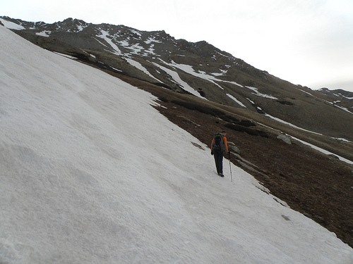
Here I am enjoying the amazing scenery we had the entire way up
blues311 crossing the first snow slope...still hardpacked that early in the morning after a good freeze
Anyone want to claim these tracks?
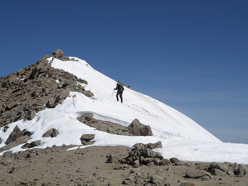
The one big snow slope we did have to climb directly really wasn't that bad. My only issue was that on the way up, one of my crampons malfunctioned and we couldn't figure out how to put it back together correctly. So while Mike blues311 cruised up, I just had to wing it and kick steps the best I could in the frozen snow, but I made it up without issue. Upon reaching the rocky line in the picture below, I just scrambled across rock and snow the rest of the way up and it was actually a lot of fun. But either way, crampons definitely would've been preferable to not having crampons on that climb.
The snow slope we climbed
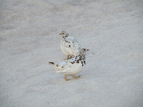
We were greeted by these two white tailed ptarmigans on the snow slope
Even though you can't see Massive's summit until you gain the ridge about half a mile from the summit on this route, there is a false summit that is within view most of the way after gaining the top of the snow slope in the previous picture. So whenever we lost the trail during brief stretches, we just kept making our own switchbacks and scrambled over rocks toward the false summit until running into the trail again. We took our time on the way up, but the rest of the climb was pretty straightforward.
Big views opening up behind us
blues311 scrambling up rock and snow
View of South Massive as we approach the ridgeline
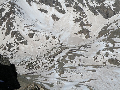
View of a good portion of the West Slopes Route...glad we decided not to do this one!
After gaining the ridge and false summit, we had about another half mile to go and a few more false summits to cross, which ended up being an awesome scramble/traverse.
The final traverse to Massive's summit in front of us...Although the peak in the middle looks like the summit, the true summit is actually to the left of this point
We ended up climbing right over this first false summit after gaining the ridge, rather going around through the snow...it was a short, but fun little class 3 scramble
Making the final push to the summit
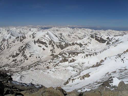
We reached the summit of Massive around 10:30 am. It was a chilly 35 degrees on the summit, but there were some nice rocks to huddle against for wind protection. The views were absolutely stunning.
Surrounding peaks still covered in white
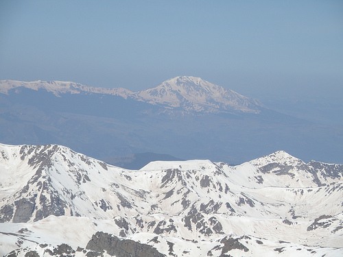
We had outstanding views of the rugged Elk Range in the distance, with the Maroon Bells and Pyramid Peak really standing out
Mt. Sopris in the distance
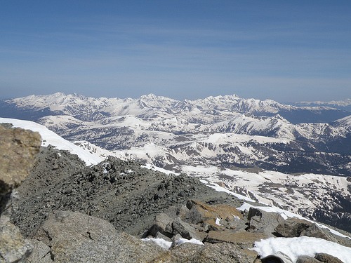
Looking northeast
Standing on the summit
The "official" summit
As we began our descent, we noticed several climbers heading up the East Slopes Route. Although it has more snow than the SW Slopes Route it looks very doable from what we could see.
Climbers nearing the summit ridge from the East Slopes
On the way down, our route was a little bit different. Since the snow was quickly softening and the snow slope we climbed on the way up seemed like it could be slidable, we skirted around the snowfield to the right on the way down, and made our way down the steep, rocky, knee-destroying slope until finally running into the trail near the valley floor. We made it back to the trailhead around 2:00, exhausted but also thrilled about our awesome day on Colorado's second highest peak.
Thumbnails for uploaded photos (click to open slideshow):
may 2009 massive TR - ski descent? 5/20/2009 7:04pm
would you say there is enough snow for a ski descent, or better to skip it? my wife, friend, son and i were going to attempt the SW slopes. the rangers are saying not a great idea...that the snow had a dust crust on top. we‘re fine doing it on crampons, but i really was hoping the snow would hold up.
The SW Slopes route did not look very skiable, there just wasn‘t enough continuous snow to make it worth it. However, when we were on the summit ridge I remember thinking that the east side looked like it would be awesome to ski. You would want to get up there very early, and might want to consider hiking in the day before and setting up a base camp, since the snow softens up quickly on eastern aspects. I had meant to add a picture of Massive from Leadville to the TR but forgot...however I just added it so hopefully that will give you an idea of what the snow is like on the eastern faces.
You are right about that road. I climbed the Same route on Massive back in late September and I was trying to drive that section at 10 at night with a ‘01 Honda CRV. I almost made it but not quite. There are some great camp spots below there and the TH is not far off. If only they would have picked up the exhaust a bit, everything else would have been fine. I guess that car keeps me honest or I would be trying to drive up mountains instead of climbing them! Great report!
I know this is a year late :) but I am looking at this same route on May 15th in a few weeks and just wondering if you ever utilized Spikes or Crampons for any of the snow field crossings. It doesn‘t appear so from your pictures.
There was only one section where we took out our crampons (I mentioned it above in the TR and posted a picture too). It wasn‘t too bad really... one of my crampons actually came apart when I took it out of my bag and I gave up trying to fix it at the time and just hiked up the snowfield... it was a little sketchy since it was early and the snow was frozen, but doable. So I would say you might as well take crampons/spikes with you, just in case. However, if you don‘t own any, there are probably ways to skirt around the snowfields if you don‘t mind going off-route a little bit (assuming the snowpack is the same or lower compared to mid May last year)
This is a great route... the views behind you as you climb are incredible when there‘s still a lot of snow on the surrounding peaks.
Caution: The information contained in this report may not be accurate and should not be the only resource used in preparation for your climb. Failure to have the necessary experience, physical conditioning, supplies or equipment can result in injury or death. 14ers.com and the author(s) of this report provide no warranties, either express or implied, that the information provided is accurate or reliable. By using the information provided, you agree to indemnify and hold harmless 14ers.com and the report author(s) with respect to any claims and demands against them, including any attorney fees and expenses. Please read the 14ers.com Safety and Disclaimer pages for more information.
Please respect private property: 14ers.com supports the rights of private landowners to determine how and by whom their land will be used. In Colorado, it is your responsibility to determine if land is private and to obtain the appropriate permission before entering the property.


")
")
")
")
")
")
")
")
")
")
")
")
")
")
")
")
")
")
")
")
")
")
")
")


