Download Agreement, Release, and Acknowledgement of Risk:
You (the person requesting this file download) fully understand mountain climbing ("Activity") involves risks and dangers of serious bodily injury, including permanent disability, paralysis, and death ("Risks") and you fully accept and assume all such risks and all responsibility for losses, costs, and damages you incur as a result of your participation in this Activity.
You acknowledge that information in the file you have chosen to download may not be accurate and may contain errors. You agree to assume all risks when using this information and agree to release and discharge 14ers.com, 14ers Inc. and the author(s) of such information (collectively, the "Released Parties").
You hereby discharge the Released Parties from all damages, actions, claims and liabilities of any nature, specifically including, but not limited to, damages, actions, claims and liabilities arising from or related to the negligence of the Released Parties. You further agree to indemnify, hold harmless and defend 14ers.com, 14ers Inc. and each of the other Released Parties from and against any loss, damage, liability and expense, including costs and attorney fees, incurred by 14ers.com, 14ers Inc. or any of the other Released Parties as a result of you using information provided on the 14ers.com or 14ers Inc. websites.
You have read this agreement, fully understand its terms and intend it to be a complete and unconditional release of all liability to the greatest extent allowed by law and agree that if any portion of this agreement is held to be invalid the balance, notwithstanding, shall continue in full force and effect.
By clicking "OK" you agree to these terms. If you DO NOT agree, click "Cancel"...
I wanted to add a report to give some beta on the area around San Luis Peak, as well as cover a bit of the actual climb that I did. If you're only interested in beta photos, you can skip the boring text in the next section.
13,285
I set off this morning to climb PT 13,285; a high peak on the continental divide north of Creede. This peak has a very broad mellow south shoulder that extends down to the valley floor, very much like Silverheels. In fact, the overall feel of this peak reminded me a lot of Silverheels, except that the soil was a soft ash instead of granite. As I was hiking along, I happened to look down at my feet and noticed the deep boot prints that I was leaving in the soft soil. At this point I proceeded to pretend that I was Neil Armstrong by making long slow motion strides along the gray lunar dust beneath me. When I realized that I must look foolish to the coyote eying me from the ridge line, I sheepishly went back to my plodding. The aspect of the peak afforded a nice snow-free climb and it provided a good look at the surrounding areas. Now for the good stuff:
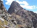
This is what the south slopes of 13,285 looked like. This is not a very good picture of the mountain, but then again, this particular mountain is not very photogenic.
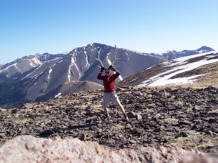
As you can see, I have acquired antlers. Unfortunately, they are crooked and are not quite as majestic as I had originally hoped they would be. This misfortune may decrease my chances of finding a suitable mate.
Here is a picture of the Yawner Gullies on San Luis. They look to be coming into prime shape for some good old fashioned scree-skiing.
Here is Organ, looking dry.
This shows the ridge from Phoenix out to La Garita Peak. A dry hike of these peaks could most likely be made at this point.
This picture is supposed to show the Baldy Cinco group of peaks, as well as some of the peaks further west near Lake City. The main point to take away from this is that there is still some decent snow on eastern aspects.
After the climb, I attempted to drive up the West Willow Creek road to see if the road was clear to the south trailhead for San Luis. I ran into one small patch of snow shortly after the Equity Mine, and I could see a couple of other patches further down the road. the trailhead looks like it should be fully accessible within the next several days.
The central theme of this report, if one is present, is that everything south facing near Creede is looking pretty much bone dry at this point. Summer has come early, so have at it. If you don't like our brown dust, I hear that the front range still has some decent snow.
Thumbnails for uploaded photos (click to open slideshow):
San Luis is on my ”to do” list in the next 2 weeks. I very much appreciate the Beta on the road and snow pack. You saved me from carrying all my ski stuff up.
Hahaha! I love that! Wow - I'm surprised at how little snow there is on that side of San Luis. I knew there wouldn't be much, but wasn't expecting that line to be out. I was surprised that Handies had as much snow as it did last weekend but Redcloud/Sunshine looked similar to San Luis. Great trip report, Chris! :D
PS- I agree with sunny1866: Nice rack! Where did you find those antlers?
Holy crap, it is mid-May, and it looks like late June..
Caution: The information contained in this report may not be accurate and should not be the only resource used in preparation for your climb. Failure to have the necessary experience, physical conditioning, supplies or equipment can result in injury or death. 14ers.com and the author(s) of this report provide no warranties, either express or implied, that the information provided is accurate or reliable. By using the information provided, you agree to indemnify and hold harmless 14ers.com and the report author(s) with respect to any claims and demands against them, including any attorney fees and expenses. Please read the 14ers.com Safety and Disclaimer pages for more information.
Please respect private property: 14ers.com supports the rights of private landowners to determine how and by whom their land will be used. In Colorado, it is your responsibility to determine if land is private and to obtain the appropriate permission before entering the property.


")
")
")
")
")
")