Download Agreement, Release, and Acknowledgement of Risk:
You (the person requesting this file download) fully understand mountain climbing ("Activity") involves risks and dangers of serious bodily injury, including permanent disability, paralysis, and death ("Risks") and you fully accept and assume all such risks and all responsibility for losses, costs, and damages you incur as a result of your participation in this Activity.
You acknowledge that information in the file you have chosen to download may not be accurate and may contain errors. You agree to assume all risks when using this information and agree to release and discharge 14ers.com, 14ers Inc. and the author(s) of such information (collectively, the "Released Parties").
You hereby discharge the Released Parties from all damages, actions, claims and liabilities of any nature, specifically including, but not limited to, damages, actions, claims and liabilities arising from or related to the negligence of the Released Parties. You further agree to indemnify, hold harmless and defend 14ers.com, 14ers Inc. and each of the other Released Parties from and against any loss, damage, liability and expense, including costs and attorney fees, incurred by 14ers.com, 14ers Inc. or any of the other Released Parties as a result of you using information provided on the 14ers.com or 14ers Inc. websites.
You have read this agreement, fully understand its terms and intend it to be a complete and unconditional release of all liability to the greatest extent allowed by law and agree that if any portion of this agreement is held to be invalid the balance, notwithstanding, shall continue in full force and effect.
By clicking "OK" you agree to these terms. If you DO NOT agree, click "Cancel"...
DISCLAIMER
I wasn't going to post this report, but when I noticed the dramatic lapse in Trip Reports recently, and then noticed that there are currently no Trip Reports for any of these peaks on 14ers.com, I figured I might as well take a stab at it! I'm writing this more as an "instructional" guide for those that would like to duplicate our climb rather than a traditional trip report. If you don't need the instructions, you can simply enjoy the pretty pictures! :-)
STATS:
Distance: 11.2 miles
Altitude Gain: ~4,000 feet
Time: 8 Hours, 25 Min
TENNEY CRAGS
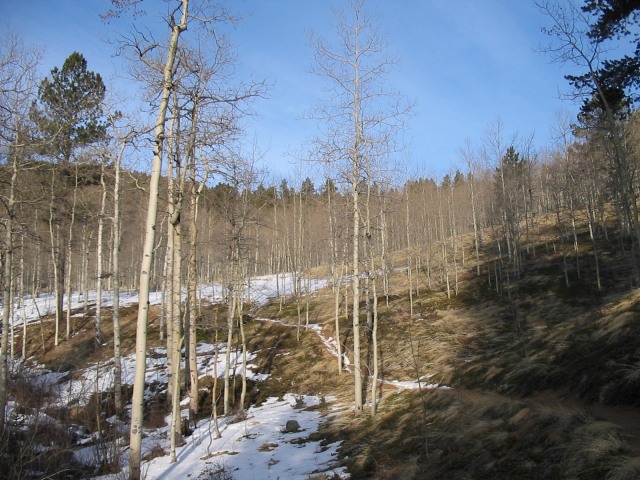
With questionable weather forecasts for most of the 14ers the weekend of 15 November, Yosemite98, Dave, and I decided to try a local hike and tackle 3 "10ers" in the Colorado Springs area. This is a GREAT year-round hike for anyone who's looking for something a little different and can be done as a loop to avoid seeing the same terrain twice!
To get to the trailhead, drive to the upper parking lot of North Cheyenne Canyon (PM me if you need directions). If doing this trail as a complete loop, I recommend parking here. If you want to do a smaller loop and retrace part of the trail back, you can continue driving 1.5 miles up the "High Drive" to a small parking area on the right. This will save you about 3/4 of a mile and some elevation, but isn't nearly as scenic.
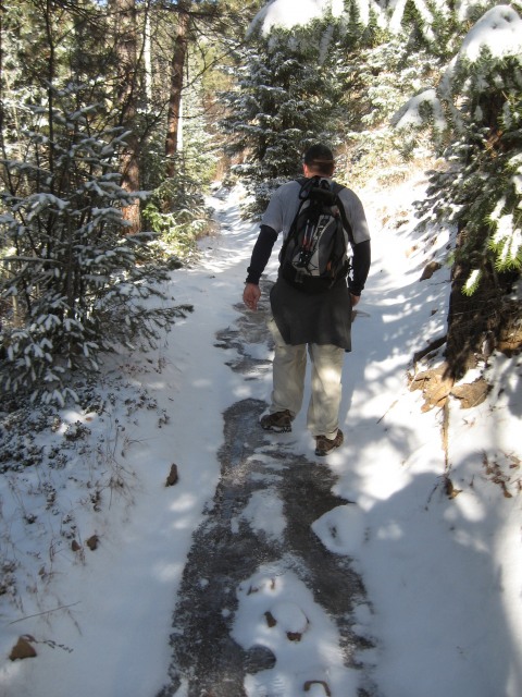
We began at 7:20 am from the upper Parking Lot (as High Drive was closed for the winter) and made our 1.5 mile climb up the road to the small parking area mentioned above. The trail starts directly across the road from the High Drive parking lot (i.e., the west side). Be careful! This trail ("Captain Jacks") is open for motorized traffic and is a favorite of dirt bikers! There are many blind corners with barely enough room for one person, so be listening! Along the trail we had this view of our first goal:
Tenney Crags can be seen just below and to the right of the moon in the picture above.
After about 1.6 miles, Captain Jacks trail crosses a stream and joins with Trail 667. We found, ironically, that this trail was covered with ice from runoff coming down the mountain to our right (i.e., in the direction of Tenney Crags).
Yosemite98 taking careful steps on Trail 667 heading towards the turnoff to Tenney Crags. The trail was completely covered with ice.
After just a half mile on Trail 667, the turn off for Tenney is on the right. Now, I cannot stress this strongly enough. YOU WILL NOT SEE IT! You literally have to know right where it is. If you have GPS, put this waypoint into your receiver:
38° 47' 39.8" N
104° 55' 43.9" W
If you don't have GPS, I recommend guessing (as best you can) when you've traveled about a half mile on Trail 667, and then look for a small tree right in the middle of the trail. The turnoff is immediately to the right just past this tree. I didn't think to take a picture of it, but someone was kind enough to include one on SummitPost. See their picture of it here:
The picture in the link above is taken from the opposite direction from which you'll be approaching. This is why the turnoff is so easy to miss... If coming uphill, it doubles back... up and to the right with no cairn, sign, etc. It truly is easy to miss.
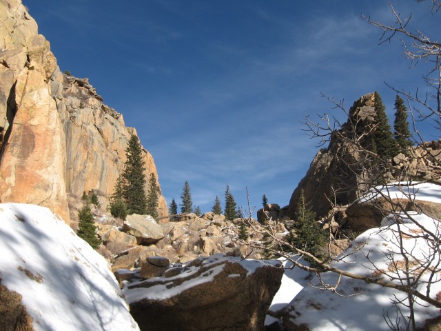
From the where you leave Trail 667 to the summit of Tenney Crags is about 1.3 miles. This is a fun hike through lots of trees and interesting rock formations. It is well cairned but does get tricky in places. Once you've ascended those 1.3 miles, you come to an opening between two large rock formations:
At the base of Tenney Crags
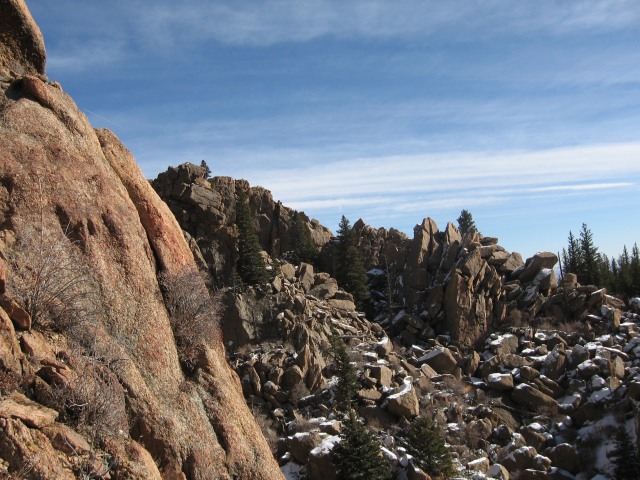
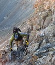
This area provides lots of opportunity for boulder hopping and Class 3/4 climbing. However, our goal was the summit and there was just enough snow and ice on the rocks to discourage us from too much exploring. To get to the top, the easiest route seems to be to the east (the left in the picture above). There is no real trail that we could discern from this point. It's just a bit of bushwacking and bouldering to the summit circling clockwise around the big rock formation.
Starting our way up towards the summit. This is looking due east. The previous picture was taken down in the extreme bottom right corner of this picture.
Yosemite98 trailblazing up the rocks. Much of the way to the summit from the base looked like this. Great fun for those that like a little Class 3 scampering!
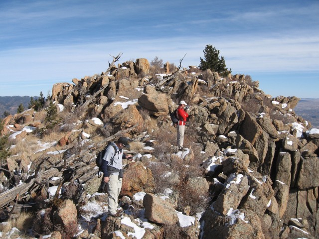
We reached the summit at 10:18 am. Almost 3 hours exactly from the trailhead.
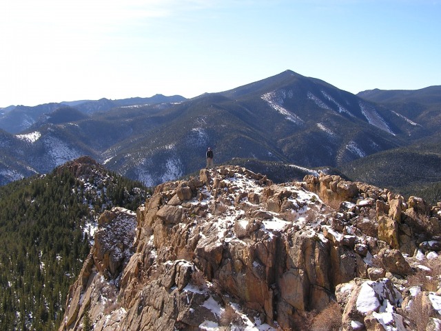
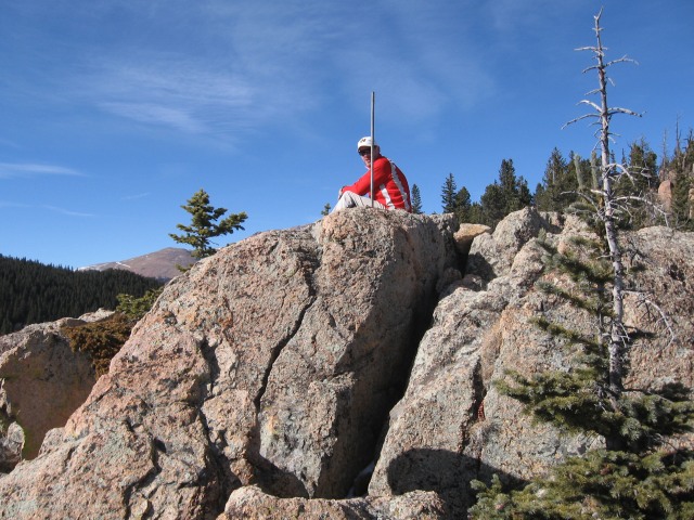
Yosemite98 (Grey T-Shirt) and Dave (Red jacket) on top of Tenney Crags enjoying the view of Colorado Springs to the East.
Me at the south end of the Tenney Crags summit. Mt Rosa can be seen behind me and to the right.
Cameron Cone can be seen to the North.
MOUNT ARTHUR
From this point, we needed to plan our way carefully. There is NO trail between Tenney Crags and... well... anything else except the way you came! Since our next goal was Mt. Arthur we scoped out a rough path to bushwack to the west. You'll notice from the picture below, there is no clear and easy path. There are a lot of dense trees, rough terrain, rock formations, and fallen logs... In short... a LOT OF FUN!
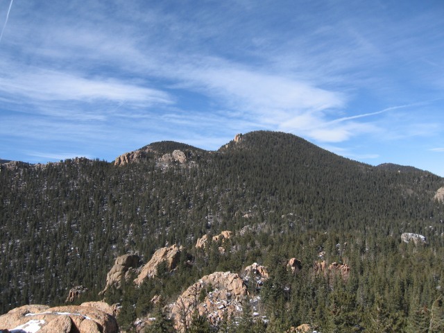
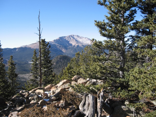
This shows the view of Mt Arthur from the summit of Tenney Crags. Mt Arthur is the tree-covered summit just right of center with a very small rock outcrop on it's left (south) side. The mountain to the left is actually Mt. Garfield (our 3rd destination). Although it looks closer and smaller, that's an optical illusion. It's actually 100 feet higher and behind Mt. Arthur.
From the picture above, we planned our route. Once in the trees, you're pretty much blind and one rock formation begins to look like another. GPS was very helpful but not essential.
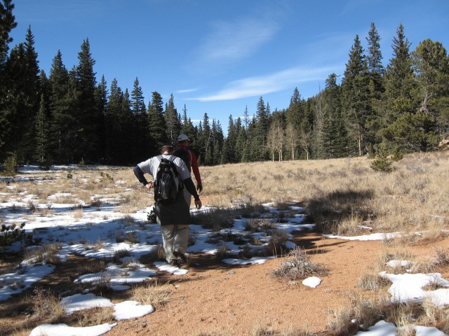
Here's a good idea of the terrain on a relatively flat portion of the hike. As you can see, we had (thankfully) just a dusting of snow. That's me on the left and Dave (barely visible ahead of me) in the red jacket.
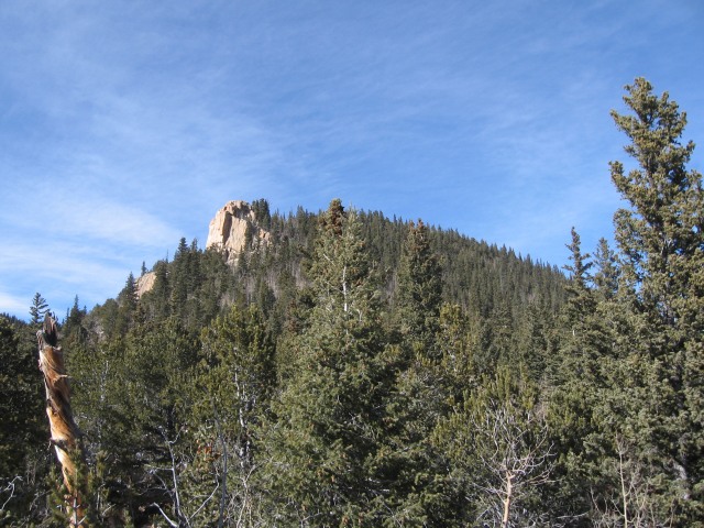
After 1.2 miles of bushwacking due west, we arrived at our destination! To be honest, the rock outcrop on Mt. Arthur was much more interesting than the summit itself (which was obscured by dense trees and offered very little in terms of a summit view). So, if doing this route, take time to relax at this spot like we did!
As you get close to Mt Arthur, the summit does become visible in places. Dave and I hiked up on a little rock outcrop in order to take this picture. Much of the summit is hidden until you're there!
We arrived at the summit of Mt Arthur at 12:00 pm (noon) just in time for lunch and spent a fair amount of time on the big southern rock face before attempting to find the summit. Which, by the way, wasn't as easy as we thought. Arthur's summit is rather long and indistinct. it was hard to decipher exactly where the true summit was. We DID however, find a small Summit Log in a glass jar and penned our names in it. We also continued north up the summit ridge a ways until we were certain there was no higher point.
Dave reached the rock outcrop on Arthur first. We found this metal pole sticking out of the rock with no explanation. Part of Almagre can be seen in the distance to the west.
Looking back to the east, Tenney Crags can be seen in the distance (to the left of center).
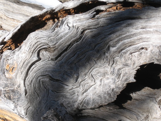
Of some interest on Mt Arthur, we found this tree that had apparently been twisted and gnarled by lightening.
MOUNT GARFIELD
The trek from Mt. Arthur to Mt. Garfield is also a bit of a bushwack, but an easy one. There is about a 200-foot descent down Arthur to an open saddle and then a 300-foot ascent to the summit of Garfield. The entire distance is only about 0.6 miles in length. One recommendation though: Go WIDE to the right and approach Garfield from the North. If you try to ascend straight up the eastern face (or even the north eastern), you'll have quite a rock-scramble. While this would normally be fun, we were getting pretty tired and it just became irritable. We descended down the northern face and it was a much smoother route.
The Saddle between Mt Arthur and Mt Garfield. This is a really cool open spot between the two peaks... Wide, flat, and open, yet the trees around it make a nice wind-break. A great place for camping!
We arrived at the summit of Mt. Garfield about 1:20 pm, which wasn't too bad considering the lunch break we'd taken on Arthur. Although Garfield is a fine mountain, this was the second summit of this peak for Dave and me. We let Yosemite98 take a few pictures at the top, but we didn't spend a lot of time site-seeing.
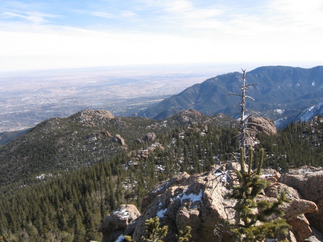
Unlike Arthur, Garfield has some great views of the region. Pikes Peak is seen here. It also has great views of Almagre, Mt Baldy, Mt Rosa, Cameron Cone, and just about every other mountain to the east of Pikes Peak! You'll also find some fascinating chunks of brilliant-white quartz crystal embedded in the Pikes Peak granite on this peak.
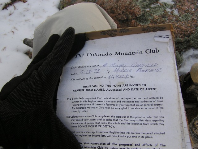
Of note, there are two summit logs on top of Garfield. One of which dates to 1979!!! Be sure to sign your name in them. Garfield (as well as Arthur and Tenney) are rarely climbed!
The oldest Log I've ever found on a peak!
THE DESCENT
As mentioned above, it is definitely better to start descending down the north side of this peak and then gradually loop to the right back to the saddle between Arthur and Garfield. There are no cairns, but the slope is easy and obvious.
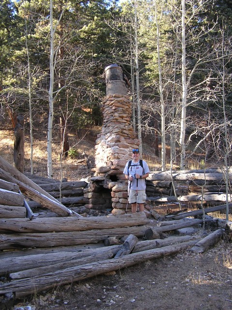
At the saddle, head due south. Cairns start to appear, but they really aren't necessary as you eventually begin following a gully (and then a stream) that leads you all the way down to Trail 667 (a fair bit further west from where you left it to climb the Tenney Crags). Along the way, there are at least 3 (maybe more) old cabins. One is difficult to see, but the other two are in plain sight. The most obvious one is Loud's Cabin which has definitely seen some damage over the years.
Yosemite98 "inside" Loud's Cabin. As I understand it, there used to be wagon train or road of some type along this path and Loud's cabin was a stopping point. That road is now gone and Loud's appears to be literally in the middle of nowhere!
It's about 1.5 miles from the Summit of Garfield to Loud's Cabin. From there, it is only a couple hundred feet until you reach Trail 667.
From Trail 667, you have a choice. If you parked on High Drive, you can follow 667 all the way back to Captain Jacks. It's about 0.8 miles to the point where you turned off to Tenney Crags. (This route passes an abandoned mine shaft on your left which is kind of interesting).
If you want to make the "complete loop", however, you'll need to go through Jones Park to 7-Bridges Trail and follow that back to the Upper Parking Lot in North Cheyenne Canyon Park. If you're not familiar with this trail, please PM me for directions. A lot of trails "converge" in Jones Park and it can be easy to head off in the wrong direction. I've done it before... twice! Here are the basics:
1. From where you enter Trail 667, turn left (southeast) on Trail 667 and follow it for about a quarter mile. Bear Creek will be on your right the whole time.
2. Eventually, you'll see a very obvious river crossing on your right that leads to Jones Park (identifiable by the large grove of Aspens). Cross the river here, heading south (and a bit southwest).
3. A short ways further (maybe a tenth of a mile?), you'll need to make a left on what looks like the wrong trail. Take it anyway, or you'll eventually be heading in the exact opposite direction you want to go!
4. Continue on this trail past Kineo Mountain (on your left) until you reach North Cheyenne Creek. Note: You can‘t actually see Kineo from the trail, but you are passing by it.
5. Make a left at the creek and follow it until you join 7-Bridges Trail. This trail snakes back and forth over N. Cheyenne Creek seven times until you reach Gold Camp Road.
6. When you reach Gold Camp Road, make a left and follow it back to the parking lot.
Again, if you haven't done this before and want to try it, please PM me for more details (GPS tracks, etc.).
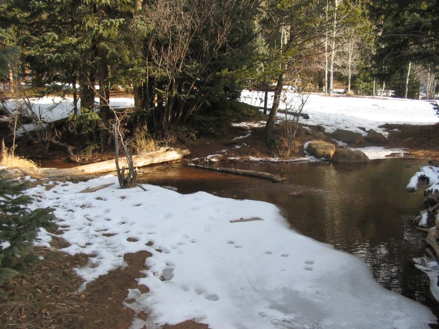
This is the Bear Creek stream crossing (taken from the far side of the stream after crossing it).
A picture of Jones Park when the Aspens are not quite at their peak!
Here's one final overview of our journey! The red line follows our path (counter-clockwise) to all 3 summits. The white line with red dots (ducking behind Mt. Kineo) is the alternate return path to High Drive.
Thumbnails for uploaded photos (click to open slideshow):
You probably found the BM and a RM. The RM (or reference Marker) will have an arrow on it pointing in the direction of the BM. The BM will have either a triagle or a point in the center indicating the actual station.
On Tenney, there should be two RM‘s, but one was missing last time I was up there. In addition, the one on Arthur is also missing. I did find the whole where it should be, but unless you have the detailed description from the USGS it will not be found easily. Garfield has one, too as do many of the other peaks nearby.
Excellent report of some hidden gems in El Paso county that are rarely visited. The view from Tenney Crags is probably the best view from any peak in the county IMO. Sounds like you guys timed that hike right with the lack of snow, because I was wallowing along that ridge in knee deep snow when I did them.
Thanks for posting a nice description of one of my favorite area. I‘ve climbed all these peaks, but never all three together (you join Kevin and, as far as I know, no one else, in this.) I also commented on how difficult that trail turn-off is to see in my TR for Arthur: http://www.listsofjohn.com/PeakStats/TripReport.php?Id=492
dcbates80911, actually, we found 2 ”Rocky” markers! We couldn‘t figure that out, but there are two distinct markers on the summit which are nearly identical. And yet we could find none on Mt Arthur which is over 700 feet higher. Go figure! :-)
dcbates80911: Thanks! I never could figure those things out, but now it makes sense.
Kevin Baker: It did end up being a great day! I've done the knee-deep stuff at other times, so I feel your pain. My personal favorite (for the view) is Mt Rosa, but I definitely enjoyed the solitude and terrain of Tenney more than just about any other!
Brad: Tuckaway is on my list for 2009 as well. Drop me a PM if you climb it and let me know how it goes! Or, if you‘re looking for a hiking partner, let me know that too.
Thanks! I just read your report. I wish I would have seen it before we went on our expedition. We could have saved some time going up that first gully from the parking lot! Also, I did not see the cairn you noted in your report for Tenney. I wonder if it‘s been removed? Could be I just missed it. I know Yosemite98 and I are interested in returning to the Crags. We‘d never been to this area, but loved it!
Love this area and that trail to Tenney Crags, as you say, is very easy to miss. I didn‘t know it was there until reading about it and getting the GPS waypoint, but it was a nice and fairly secluded path in the busy summer months. There are many ”unmarked” trails in this area to explore if you can find them. Did you find the ”Rocky” BM on top of Tenney?
As for your trip over to Arthur, that had to be tough. Your description was exactly what I experienced doing Almagre‘s east approach. Took some time and energy to complete. Good job on a nice loop.
Does anybody know if the trail up to Louds cabin is still accessible? Haven't been up in that area since early this spring and seems like I heard 667 past the wood bridge was going to be decommissioned. If not, does anybody know of another way to access Garfield, Arthur, or Tenney Crags (besides Crystal Park)?
scottcjag: Great questions. I've been up Kineo/Jones Park a couple times recently, but never went the extra couple hundred feet north to see what the status is of Bear Creek. I know from coming down the west ridge of Kineo that they rerouted 667 so it no longer descends to Bear Creek from the Kineo/Buckhorn saddle like it used to. Rather, it seems to snake around Kineo to the north well above the creek and then exits at Jones Park where it meets up with 7-Bridges Trail.
So, you can definitely get to Jones Park from either 7-Bridges Trail or the rerouted 667. I'm willing to bet from there you could at least cross Bear Creek to see Louds Cabin (and Arthur/Garfield). I think the main concern was they didn't want people hiking along the creek and knocking sediment in the water to disturb the Cutthroat Trout. Tenney Crags would be a bit more difficult of a hike, but you could possibly bushwack from Mt. Arthur and back. Anyway, let me know if you have any questions on the route I'm talking about.
Thanks for the response KentonB! I have the week between Christmas and New Year's off work and with travel plans falling through I'll have some extra time on my hands. If the weather cooperates I'm planning to make the trek up there as I've never been all the way up to the top of Garfield. I'll post a new report if I'm able to do it.
I went up to Louds cabin on 12/31/2017 and it's accessible. From the junction of new 667/622A just above the aspen grove, take a left then after 50 yards or so take the first right which will go down the hill a bit then crosses Bear Creek passing the decommissioned trail up to Louds Cabin. From Louds Cabin the trail up to the saddle between Garfield and Arthur is still well marked with cairns. I also tagged Tuckaway after Arthur/Garfield.
Caution: The information contained in this report may not be accurate and should not be the only resource used in preparation for your climb. Failure to have the necessary experience, physical conditioning, supplies or equipment can result in injury or death. 14ers.com and the author(s) of this report provide no warranties, either express or implied, that the information provided is accurate or reliable. By using the information provided, you agree to indemnify and hold harmless 14ers.com and the report author(s) with respect to any claims and demands against them, including any attorney fees and expenses. Please read the 14ers.com Safety and Disclaimer pages for more information.
Please respect private property: 14ers.com supports the rights of private landowners to determine how and by whom their land will be used. In Colorado, it is your responsibility to determine if land is private and to obtain the appropriate permission before entering the property.