Download Agreement, Release, and Acknowledgement of Risk:
You (the person requesting this file download) fully understand mountain climbing ("Activity") involves risks and dangers of serious bodily injury, including permanent disability, paralysis, and death ("Risks") and you fully accept and assume all such risks and all responsibility for losses, costs, and damages you incur as a result of your participation in this Activity.
You acknowledge that information in the file you have chosen to download may not be accurate and may contain errors. You agree to assume all risks when using this information and agree to release and discharge 14ers.com, 14ers Inc. and the author(s) of such information (collectively, the "Released Parties").
You hereby discharge the Released Parties from all damages, actions, claims and liabilities of any nature, specifically including, but not limited to, damages, actions, claims and liabilities arising from or related to the negligence of the Released Parties. You further agree to indemnify, hold harmless and defend 14ers.com, 14ers Inc. and each of the other Released Parties from and against any loss, damage, liability and expense, including costs and attorney fees, incurred by 14ers.com, 14ers Inc. or any of the other Released Parties as a result of you using information provided on the 14ers.com or 14ers Inc. websites.
You have read this agreement, fully understand its terms and intend it to be a complete and unconditional release of all liability to the greatest extent allowed by law and agree that if any portion of this agreement is held to be invalid the balance, notwithstanding, shall continue in full force and effect.
By clicking "OK" you agree to these terms. If you DO NOT agree, click "Cancel"...
Too squeeze in a little more training for climbs of Elbert and Bierstadt later in the week, we hiked down the the bottom of the Black Canyon Canyon of the Gunnison. This canyon is around 2,000 ft. deep but it contains Colorado's tallest vertical cliff; the Painted Wall 2,700 ft. high. All routes into the canyon are super-strenous according to the National Park Service. The easiest route which we descended was 1 mile long dropping 2,000 ft. in that one mile. The route is located in the Black Canyon of the Gunnison Wilderness Area, which is one of the most rugged wilderness areas in the country. Permits were required even for day-use. We woke up from our Montrose hotel at 7:00, made ourselves some waffles and drove 15 miles up to the National Park. Once we got there at 8:30 we filled out the complex permit forms. We took one permit with us and the ranger kept the other. The nice ranger gave us a long talk, "You need to be prepared for all weather and it is be 10 degrees warmer at the base of the canyon. The river runs around 38 degrees, please no swimming. If one of you gets hurt be prepared for self rescue. SAR will come looking for you after 24 hours. Be prepared for the steep trail by wearing hiking boots. You may want gloves for the chain. Pack out all our litter. Bring a gallon of water per person per day or at least have 3x as much water for coming back up than you had for going down. On the steepest section there is an iron chain. You belay yourself down backwards over steep rock for 100 vertical ft. Oh, and the last thing is the most important. Have fun, but be safe."
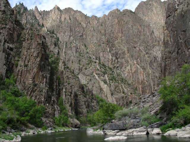
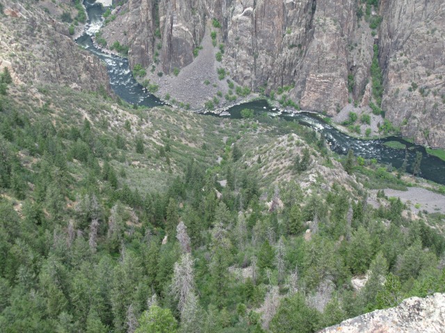
Here was our first view of the canyon. Here is the visitor center perched on top of the cliff. Here is an image that shows our route into the canyon, the red is the trail and the black part is the chain's location.
We started our hike around 9:00. The first 1/3 of a mile went down 400 ft. on the gentle Oak Flat Nature Trail. After several swich-backs, we came to our turn off. There was a small wooden sign saying Entering wilderness permit required beyond this point. No dogs or fire. We turned off onto our unmaintained route and immeditatly entered a confusing maze of trails that all went down steeply. We moved down through this part pretty quick. About a minute after we left the Oak Flat Trail we met another group of hikers. These were three college kids who had backpacked down for one night. One of them had a guitar case strapped around his neck. I asked him how much he played on it. He said, "I was so tired from hiking down here I played one song and fell asleep. Big Mistake dude, this is pretty heavy to carry around your neck." The night before I took a picture of the bottom of the canyon and noticed a little white speck in it, I later found out it was the guys who were camping down there.
About 10 minutes after meeting them we reached the top of the famous chain. Nate went down first and I followed, after me came my dad. The first part was the steepest, a near vertical 10 ft. high wall of crumbling rock. The gully's steepness relented considerably, but the rock became much looser. After going down about 40 ft. the chain dropped steeply down a loose gully to the right. Here is Nate heading down the first part. This is the view from 1/3 down the chain. Here I am dropping down into the rubble filled gully.
After the chain ended it was onto the scree. The ranger warned us about how loose and steep it was. She also told us about the importance of yelling rock. Good Advice. The gully we were in was only about 8 ft. wide and loaded with loose rocks. The bad thing about this gully was the fact that there were little 3 ft. dirt walls on both sides that funneled all falling rock down. There was one spot where I climbed down a boulder, around a corner, and squeezed by a bush that almost blocked the gully. Suddenly, my brother started yelling, " Rock, Rock, Rock!" I heard a rock coming down but couldn't it see due to the bush. Then this watermelon sized rock smashed through the bush and lands about a foot to my left. Soon after this the gully became much wider and the angle relented.
The scree went seemed to go on forever. Every so often the gully steepened and narrowed, but it soon would get wider again. The river gradually got louder as we descended but it sure didn't look any closer. Eventually after 45 minutes were reached the bottom of the canyon. It was a spectacular place with the Gunnison River roaring in Class 4 rapids nearby and the soaring 2,000 ft. high canyon walls in all directions. Along with the three backpacking campsites, there is even a decent composting toilet. After 45 minutes of exploring along the river and resting we started our tiring trek up to the rim. Here are some pics from the bottom and coming up. This was a cool rock where you could stand in the middle of the river. The sheer walls of the canyon were amazing. This rock was a little tricky to get around going up the chain. Here is a view down the route from a cliff near the rim.
Coming up took just as long as coming down into the canyon, but going up was way harder. After our hike we drove to the Painted Wall Overlook were we viewed the 2,700 cliff. The Painted Wall
Black Canyon of the Gunnison National Park is a great stop on the way to the San Juans and has great scenery. You can see the San Juans far on the southern horizen. The West Elks aren‘t far from the north rim.
Thumbnails for uploaded photos (click to open slideshow):
Thanks for the belated report. I have not yet heard about this area, but it looks like a really fun and scenic hike. I may have to check this place out next summer.
George Kaplan: You should check the canyon out, it‘s awesome.
Yog: I love it too, next head to the bottom for a whole new perspective.
Caution: The information contained in this report may not be accurate and should not be the only resource used in preparation for your climb. Failure to have the necessary experience, physical conditioning, supplies or equipment can result in injury or death. 14ers.com and the author(s) of this report provide no warranties, either express or implied, that the information provided is accurate or reliable. By using the information provided, you agree to indemnify and hold harmless 14ers.com and the report author(s) with respect to any claims and demands against them, including any attorney fees and expenses. Please read the 14ers.com Safety and Disclaimer pages for more information.
Please respect private property: 14ers.com supports the rights of private landowners to determine how and by whom their land will be used. In Colorado, it is your responsibility to determine if land is private and to obtain the appropriate permission before entering the property.


")
")
")
")
")
")
")
")
")
")
")
")
")
")
")