Download Agreement, Release, and Acknowledgement of Risk:
You (the person requesting this file download) fully understand mountain climbing ("Activity") involves risks and dangers of serious bodily injury, including permanent disability, paralysis, and death ("Risks") and you fully accept and assume all such risks and all responsibility for losses, costs, and damages you incur as a result of your participation in this Activity.
You acknowledge that information in the file you have chosen to download may not be accurate and may contain errors. You agree to assume all risks when using this information and agree to release and discharge 14ers.com, 14ers Inc. and the author(s) of such information (collectively, the "Released Parties").
You hereby discharge the Released Parties from all damages, actions, claims and liabilities of any nature, specifically including, but not limited to, damages, actions, claims and liabilities arising from or related to the negligence of the Released Parties. You further agree to indemnify, hold harmless and defend 14ers.com, 14ers Inc. and each of the other Released Parties from and against any loss, damage, liability and expense, including costs and attorney fees, incurred by 14ers.com, 14ers Inc. or any of the other Released Parties as a result of you using information provided on the 14ers.com or 14ers Inc. websites.
You have read this agreement, fully understand its terms and intend it to be a complete and unconditional release of all liability to the greatest extent allowed by law and agree that if any portion of this agreement is held to be invalid the balance, notwithstanding, shall continue in full force and effect.
By clicking "OK" you agree to these terms. If you DO NOT agree, click "Cancel"...
"Chappelle Ridge" - Solo Climbing, Rappel, and an Awesome Day in the Ruby Range
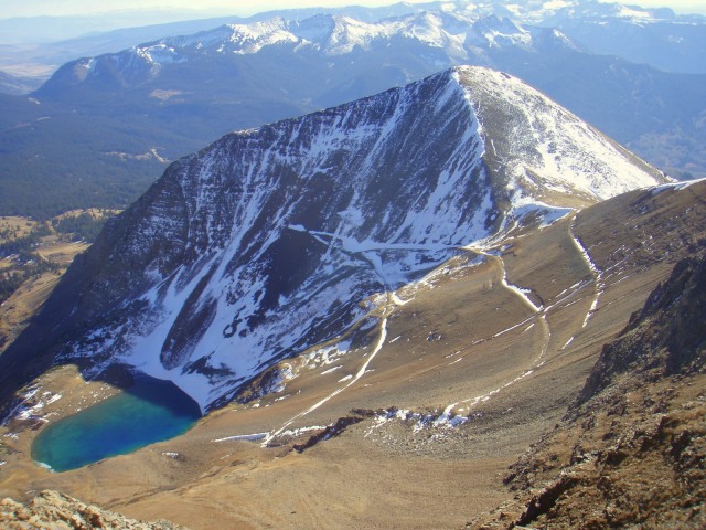
Summits: Scarp Ridge, Purple Peak, Mount Owen
Route: Scarp ridge trail, Purple Peak's East Ridge (Chappelle Ridge), south along range crest to road, road back to trailhead
Distance: ~8 miles
Elevation gain: ~3,300 feet
Participants: stevevets689
My route. Note that the big loop on the way back was due to following a road
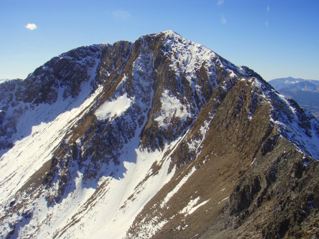
"Chappelle Ridge" on Purple Peak
The climb to the top of Purple seemed to go ok, and the rest of the way to the top of Mount Owen looked to be alright, so there I stood back in the notch looking up my rappel rope. The rock going up to the bolts starts out in an overhang, and I really didn't feel like testing my ability to climb up it, what with steep couloirs going down to both the right and left, neither of which I felt like rolling down. This was my last chance to ascend the rope and climb back down the ridge, but seeing that the rest of the way over Owen seemed to be clear I decided that was the best way down. I grabbed one side of the rope, took a deep breath, and pulled it. The rope pulled smoothly through the carabineer I left clipped to the bolt and dropped in a pile at my feet. My escape officially cut off, I quickly coiled the rope, slung it over my shoulder, and climbed back to the top of Purple Peak.
Wednesday's Rescue Group meeting was over and I had a couple hours to decide what I was going to hike on my class-free Thursday. I returned to my room and messed around with Google Earth, thinking of everything from Handies Peak to Gothic Mountain, near Crested Butte. I couldn't really decide and mentioned my dilemma to my roommate, whose immediate response was to check out Lake Irwin and Ruby Peak. I checked the area out on Google Earth and Mount Owen caught my attention. At first I thought I should climb over Ruby Peak to get to Owen, but then I noticed Purple Peak in the background. Upon further investigation, the East Ridge appeared to be very steep and sharp, but manageable (as far as I could tell from a rendered 3D image).
Next I checked Lists of John (listsofjohn.com). Purple peak isn't a ranked peak, with only 160 feet of prominence, but what with that East Ridge I didn't care. I did notice that nearby Scarp Ridge was ranked, however, so why not hike that en route? As my plan settled into solidity, the day's list became Scarp Ridge, Purple Peak, Mount Owen, and Ruby peak. I had little knowledge of the route difficulty, but I could estimate the mileage and elevation gain. I figured that all I would need would be basic hiking gear, but decided to load my pack up to increase the load and threw in my 30 meter rope and my harness, along with my ice ax, though I probably wouldn't need any of it. No reason to start super early, the forecast is beautiful. I set the alarm for 7AM so I could get hiking by 8:30.
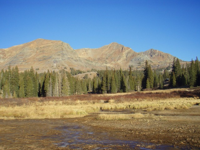
Ruby, Owen, and Purple from Lake Irwin
Plans went perfectly for the morning and I arrived at Lake Irwin just before 8:30. I brought along some topo maps I had printed out and started walking around Lake Irwin. The mountains looked beautiful in the morning, and Purple Peak was already looking intimidating. I crossed the stinky inlet to the lake and started climbing the steep hill on the other side. I came across a dirt road leading to a large, green roofed building which had no trespassing signs on it, but then noticed a couple other signs saying, "Scarp Ridge Trail." Pleasantly surprised by a well worn trail, I followed it gradually above timberline and on to the top of Scarp Ridge at 12,212 feet. The views were already pretty open to all directions except the west, where Mount Owen and Purple Peak were standing. I turned my attention to Purple Peak and began descending towards it.
Heading towards the summit of Scarp Ridge on a good trail
Owen and Purple from Scarp Ridge
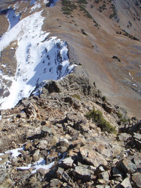
Traversing on a sketchy trail through some dwarf spruce trees, Purple Peak seemed to grow in size and steepness. Eventually I arrived on a plateau near the base of the ridge I was about to attempt. Looking up at the ridge from here reminded me of pictures I have seen of the standard route of North Maroon Peak, and I reminded myself that I was alone with a limited ability to rappel if I got stuck. My mantra for the climb became, "can I downclimb this?" and I hustled up a scree slope to the base of the ridge. The view was intimidating, but exhilarating at the same time. I started the climb.
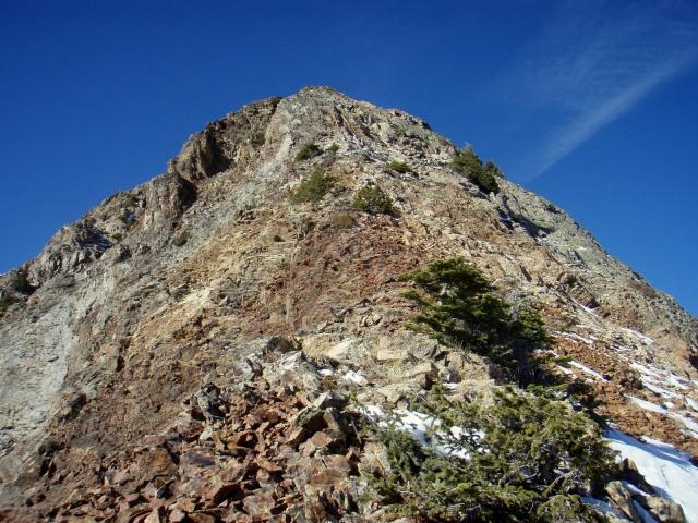
Looking up Purple from the base of the ridge
Things started off with what might have been the hardest part of the ridge. The ridge crest flared out in a small buttress which probably went at class 5 if you took it directly. I carefully skirted the bottom of it to the right on partially snowy slopes, and then found a broken, somewhat rotten face to climb up and gain the ridge. The climbing was already very real, with real consequences. I came up with a second mantra and mentally chanted, "Don't fall... Can I downclimb this?" as I continued up and got back to the ridge crest.
A ledge traverse to easier terrain
Said easier terrain... up to the left
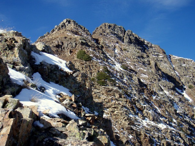
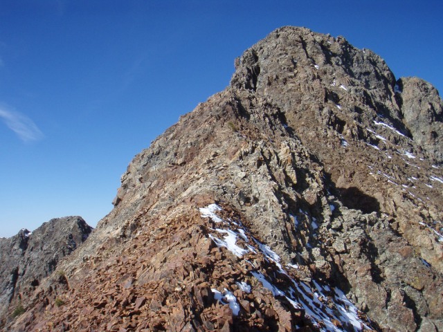
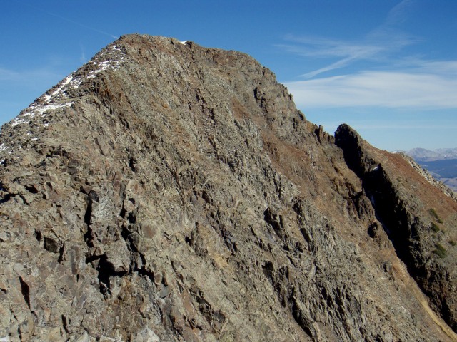
From there the ridge eased up a little, going mostly at class 2 and 3 with a couple 4 moves here and there. The climbing was wonderfully fluid for a distance until I arrived at another buttress high on the ridge. This time traversing around would only increase the difficulty, but the crest was no harder than class 4 and the second buttress went by pretty easily. On top of the buttress I stopped for a longer break and looked up at the now visible summit plus what appeared to be another tower. Once I got hiking again (the difficulty had gone down to class 2) and arrived at the "tower," I discovered that it was just a rise in the ridge and not really a tower. So it appeared that only the summit cone would hold more difficulties, and it wasn't far away now. I kept going, feeling excited that I was almost there, looking up at the steepening summit and wondering what would be the best way up, when all of a sudden I was looking down a roughly 30 foot deep gap in the ridge. Uh oh...
Looking up the ridge
The summit and the tower that wasn't a tower
Looking back down
Seemingly almost there
Progress blocked
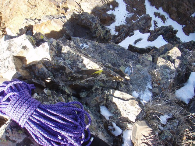
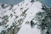
The downclimb into the gap looked to be nearly vertical. I wondered about maybe rappelling it but decided to look for a way to get down first. I took my pack off and started down, but right as I started lowering myself I found a pair of bolts in the rock. I stared at them in disbelief. Bolts on an unranked 12er? They appeared to be almost brand new. I gave some hard tugs on them and they appeared solid. I decided to keep downclimbing to see if it was possible, but the fact that someone had put bolts up here made me doubt that possibility. Sure enough, after maybe 20 feet of downclimbing on borderline class 4 to 5 terrain, the rock turned into an overhang. No way am I downclimbing that. There is snow in the gap that might break a jump, but what if it didn't? Not worth the chance. I climbed back up and rested for a moment. Things were looking a little sketch. I decided that I had two choices: go down, or rappel into the notch and continue climbing. I looked across the gap at the rock on the other side; it looked really hard, but probably doable. Deciding that it was worth a shot I got out my rope and harness, neither of which I expected to need on this climb. I put on my harness, double checked myself to make sure everything was doubled back, and clipped a locking carabineer to one of the bolts. Then I uncoiled the rope, clipped the middle of it into the carabineer, and threw it down into the gap. Finally I put my pack back on, situated myself by the rope, attached myself to it with my belay device and a 5mm prussic above it to back myself up, and began my first ever alpine rappel.
The bolts, my rope, and the notch behind them
Of course, the fact that I was at around 12,700 feet had nothing to do with my rappelling ability and it went fine, but it somehow felt like the hardest rappel I had ever done. I was somewhat nervous, what with being alone and not knowing what the terrain ahead was going to be like. I got down to the bottom of the notch and stood on the snow. I took myself off rappel but left the rope where it was for the moment. I looked around. The wall I had just rappelled down started with an overhang that went up for about ten feet. To my right and left, couloirs went steeply down to unseen slopes. I turned around and looked up towards the summit, and the terrain looked like a go, though steep and difficult. I still had a chance to turn around if I needed to by ascending the rope back to the ridge, and I preferred to keep it that way until I knew the rest of the terrain would take me over Mount Owen and down. I left the rope behind and started climbing. The first 15 vertical feet of climbing went at tough class 4 and then the difficulty eased to a rubble gully going up and around the right side of the tower. It was only about 70 vertical feet of climbing to the top, and I set my pack down for a moment. I walked down the ridge towards Mount Owen a little bit to make sure that it would go ok, and it seemed that it would only be class 2 terrain the rest of the way. Satisfied, I returned to the summit, climbed back down to the notch, retrieved my rope, and climbed back up to the summit. It's all or nothing now. I had taken over an hour to get from the gap to this point, and it was now afternoon. I dubbed the ridge "Chappelle Ridge" after Dave Chappelle, since Purple Peak is made of a lot more than sugar, water, and purple.
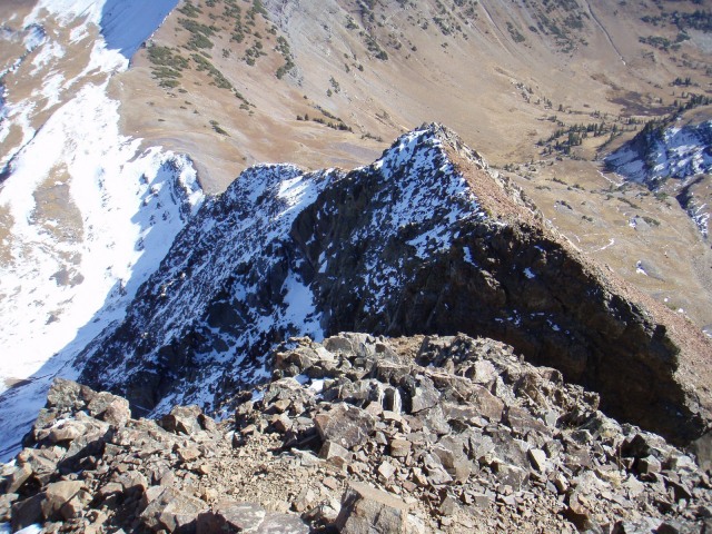
Looking down on the notch from near the summit
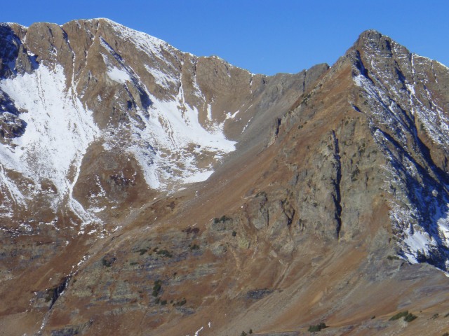
Mount Owen from Purple Peak
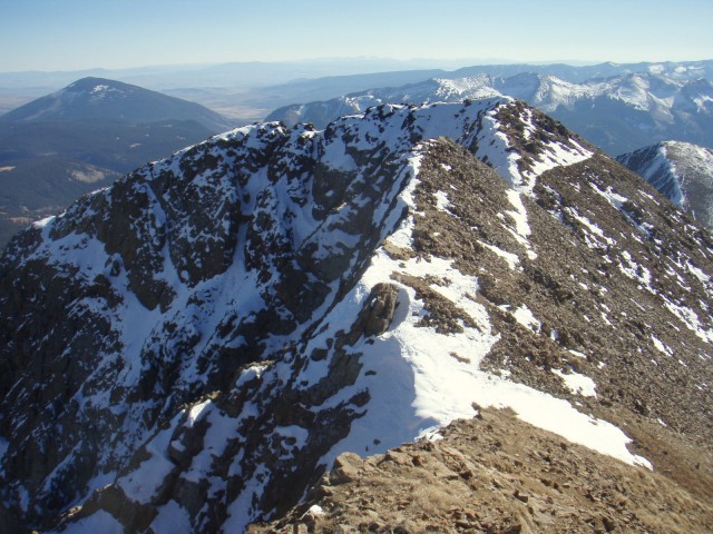
The ridge across to Mount Owen went well. There was snow on the right side, and cliffs on the left, so it was the snow that I stuck to. The sun was shining across the upper snows near Owen's summit and gave it a very icy look, and I felt suddenly wonderful over the successful climb of a ridge I knew basically nothing about, and it only took 50 minutes to reach Owen's summit. I planted my ice ax into the summit snows and yelled in excitement. I had never felt better on the summit of a mountain than I did there. I looked back at Purple Peak and Chappelle Ridge with a huge sense of accomplishment coursing through my veins. I continued with my normal summit rituals, put my pack back on and continued south.
Looking back on Purple Peak. Chappelle Ridge is on the right, and the tower is where I had to rappel
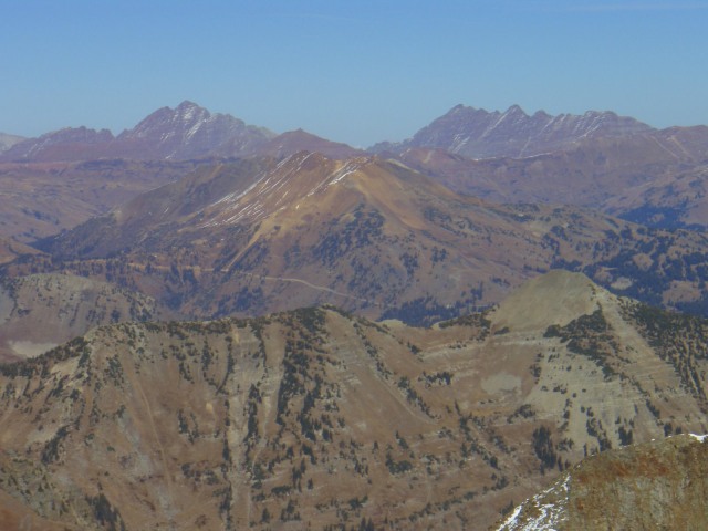
The Maroon Bells, Pyramid Peak, and Thunder Pyramid from Mount Owen
Looking down the south ridge of Mount Owen
The south ridge went smoothly and easily all the way down to the saddle with Ruby Peak. I was running later than I expected and wanted to be in Crested Butte by 5:00 so I decided to scrap Ruby from the plan and continue down from the saddle. I found myself on a switchbacking road, and since I had seen some cliff bands lower in the basin from Scarp Ridge, I picked the road as my best line to get back to the trailhead. This probably added a couple unnecessary miles to my trip, but at least it was easy going and route finding wasn't an issue. I arrived back at my car at around 4:15.
Looking down at the road I would walk out on, and Ruby Peak
Looking back up at Ruby Peak, which I'll go over the top of next time I do this
Purple Peak and Chappelle Ridge
This is a route that I expect to repeat. It was one of the more fun climbs I've done with a mildly technical spice to it, and though I was under a little stress in avoiding getting myself in trouble alone in the mountains, I've never experienced such exhilaration. It was the most fulfilling solo adventure I've ever partaken in.
Great description conveying the decisions, especially the, rapell, one must make on an exploratory route. I particularly liked the circular style where one goes up one ridge and down another, for example the Maroons traverse or Harvard and Columbia. Even better on this route would be to go up Ruby via the South (?) ridge on your map. Is this practial?
We did the ridge in the reverse direction after the 14ers fall gathering this year. Ruby to Owen to Purple and down the ridge. Where you rapped, we skirted around to the north in the gulley below the gap. It was very sketchy and should have been protected!
Sounds like the snow made it even worse!
I had no idea there were bolts there, but in the reverse direction we couldn‘t have got to them without trad gear.
Nice to know there are bolts on that nasty ridge. Purple is not an easy peak, and much harder than the taller, Purple Mountain, to the north. I climbed a chute to the left of the ”S” from Oh-Be-Joyful, and had to find another way down off the north ridge.
...from the South is probably fine, seeing as I was going to head down that way until I decided to bail on Ruby. But I wouldn‘t reverse the route, seeing that you would have to get over or around the tower on the ridge instead of rappelling it, like they did on the fall gathering.
Wow cheeseburglar, I just remember looking down both those gullies and thinking ”no way is there a way around this.” I was so happy I decided to bring my rope, I would not have gotten to the top without it.
Is it just me, or does the Northeast face of Owen look inviting for a spring snow climb?
Yeah, stevevets, these are fun snow climbs as well. Your rappel was an interesting downclimb in ski boots a couple of springs ago, although I think snow made it easier. Here‘s a TR: http://www.tetongravity.com/forums/showthread.php?t=83655 Looks like a fun day.
Nice, gb! It looks like there was a ton of snow in that notch, that must have made it a lot easier. The bottom part of the downclimb must be angled at some 100 degrees from horizontal, and I didn‘t try to climb it but my guess is it would be a 5.9ish (very uneducated guess). I‘ll have to return in the spring.
from the south is sure doable. I think that is the way they took for the fall gathering. you gain the ridge at the saddle between ruby and the dyke. i did it via the eastern ridge and i don‘t think i would go up that way again.
also, i like the way your report is written steve. good stuff!
Caution: The information contained in this report may not be accurate and should not be the only resource used in preparation for your climb. Failure to have the necessary experience, physical conditioning, supplies or equipment can result in injury or death. 14ers.com and the author(s) of this report provide no warranties, either express or implied, that the information provided is accurate or reliable. By using the information provided, you agree to indemnify and hold harmless 14ers.com and the report author(s) with respect to any claims and demands against them, including any attorney fees and expenses. Please read the 14ers.com Safety and Disclaimer pages for more information.
Please respect private property: 14ers.com supports the rights of private landowners to determine how and by whom their land will be used. In Colorado, it is your responsibility to determine if land is private and to obtain the appropriate permission before entering the property.