| Report Type | Full |
| Peak(s) |
Sunshine Peak - 14,004 feet Windom Peak - 14,089 feet Mt. Eolus - 14,087 feet |
| Date Posted | 09/01/2008 |
| Date Climbed | 08/29/2008 |
| Author | mtnmike |
| Chicago Basin 3-fer to complete the 14ers! |
|---|
|
Finally, the chance to climb the last 3 14ers of the 54 and complete the Grand Slam! We drove to Durango from Denver on the Wednesday before the long Labor Day weekend, battling I-25 road construction and crawling RV's on US 160 over Wolf Creek pass. The original plan was to get the train and hike in on Thursday, spend Friday & Saturday climbing, hike/train out Sunday, and then drive home on Monday (Labor Day). The forecast originally looked good for this plan, but gradually started to deteriorate towards the end of the weekend. Chris and I decided to make the weekend a little shorter and more aggressive, coming out of Chicago Basin on Saturday instead of Sunday. We figured we could either grab one peak the day we hiked in, or one the day we hiked out. Since we wouldn't pick up the train until 3:30 or so in the afternoon, the latter seemed pretty reasonable. After an uneventful drive to Durango a carb-loading dinner at Fahrquart's on Main Street and an equally uneventful night, we showed up as directed at the Durango-Silverton Narrow Gauge Railroad depot at about 8:15 on Thursday morning. One of the conductors led us to the ancient boxcar at the head of the train to load our packs.  Loading packs onto the boxcar... Right on schedule we headed out of Durango at 9:00. The DSNGRR is a fantastically scenic ride from Durango to Silverton, winding through steep canyons, narrow passages (4 inches of clearance, in some places!) and generally jaw-dropping vistas.  The DSNGRR 'money' shot, as the train slowly creeps over steep canyons... It's also a fantastically SLOW ride, as the train never gets above 20mph. Not that there's anything wrong with that in itself, but when you're chomping to strap on the pack and get climbing, the two and a half hours between Durango and the Needleton stop can drive you nuts! Of course, eventually we pulled into the Needleton stop, which really consists of little more than a space besides the tracks and a suspension bridge across the Animas River. We unloaded our packs (an additional 8 climbers were with us) and waved to the departing train and it's throngs of tourists wondering what these people were doing, getting off the train in the middle of nowhere. The hike into Chicago Basin was, for the most part, quite pleasant and also incredibly scenic. The ~6 mile hike can be roughly broken into thirds - the first third is a mellow but steady climb up the valley, the second is a more moderate climb, and then the third levels off to be a bit more mellow as you enter Chicago Basin. Hiking beside Needle Creek was definitely a highlight, as the spectacular falls and rushing waters piled over each other to the point where you start looking for people making beer commercials that tout the characteristics of their mountain water.  Approaching Chicago Basin... After about three and a half hours we made it deep into Chicago Basin and found excellent camping just about 100 yards down from the turnoff to Twin Lakes. Even though it was only 3:30 and the skies were favorable, the thought of heading up to try a summit was pretty much out of the question...we'd both spent ourselves pretty well getting to our campsite. So instead it was a leisurely afternoon of setting up camp, cooking dinner (gotta love those MountainHouse meals!), and staring down the local mountain goat and deer populations, both of which were obviously quite used to humans and not shy about investigating camps! We decided to turn in relatively early so we could be up and moving at first light, and see where the day would take us. The mostly quiet evening was punctuated from time to time by the shuffling of animal feet and the occasional nuzzling of our tents. On Friday morning we were up at 5:00 or so, still dark but warm enough even at that hour that shorts and short sleeves were plenty to keep warm. After breakfast, packing the daypacks and hanging out food bags out of reach of the locals it was just after 6:00, and we tromped up the trail to Twin Lakes with Windom being our first target. The trail junction and the trail to Twin Lakes are both very well marked, with plenty of signage and cairns to guide you, including some spots where the trail crosses multiple rocky slabs. The grunt up to Twin Lakes is also steep and arduous, at least that was our impression. We arrived at Twin Lakes a bit after 7:00, sweating hard in the cool morning air and watching low clouds lurking around the summits above us, boiling off in the morning sun.  Low morning clouds punctuate the peaks as the sun rises... From Twin Lakes the three 14ers make themselves somewhat more apparent than from Chicago Basin. Looking left shows the blocky bulk of Eolus. Just right of center is Sunlight and the unmistakable Sunlight Spire. And far right, peeking from behind Jupiter Mountain is Windom. Accordingly, we following the faint trail far right and began ascending into the basin between Sunlight and Windom, dodging the occasional group of mountain goats, eternally curious about the 2-legged visitors (and I'm sure, hoping for Clif Bar remants to drop!).  A family of mountain goats blocks the trail to Windom (in the background)... There are a couple options for Windom from here - you can either continue into the basin between Windom and Sunlight and then pick your point to turn right and ascend the rubble to the saddle between Windom and Jupiter, or you can do a long, gradual ascending traverse on the (climber's) right side of the basin, beneath Jupiter, aiming for the saddle. Either one requires plenty of class II scrambling over mostly solid rock. We ended up doing the former and made the saddle at just about 7:45, give or take. From here it's a relatively straightforward trek up the ridge to Windom's summit. The faintly cairned trail sticks to the climber's left of the ridgeline itself, and again requires plenty of Class II scrambling on mostly solid rock. Sticking to the left side of the ridge, the cairned path actually passes the summit by a few yards, requiring just a little backtrack, but nothing overwhelming. We hit the summit at 8:30, just as the sun was starting to warm the day up. The summit of Windom is quite blocky and frankly more exposed than I had been thinking. Not 1000-foot drop exposed, but still somewhat airy. We settled in for some water, gorp and Clif Bars, gathering strength for Sunlight, which sat tantalizingly close, just across the basin. 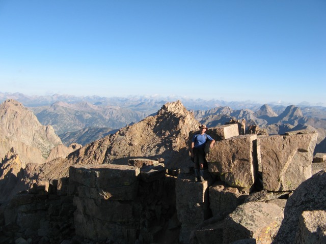 Chris on the blocky summit of Windom... Heading off of Windom's summit we came to a prominent notch in the ridge (I'm guessing 200 or so yards from the top,but quite obvious). There was a small network of trails heading straight down into the basin, and we judged that we could save some time and elevation loss here.  Descending Windom... The steep scree and gravel weren't as bad as some mountains (i.e. Columbia), and within a half-hour or so we had bottomed out high in the basin at 13, 300' and begun the slow, grinding cimb up Sunlight, which was also a somewhat loose trail of scree and gravel. We had a trio of climbers ahead of us, and another pair far below, so the danger of rockfall wasn't too bad. Nearing the saddle between Sunlight and Sunlight Spire, the trail takes a left turn and begins to do an ascending, Class III traverse between the rocks and through a couple small chimneys. Eventually the trail tops out on the ridge and requires a tricky maneuver through a low-ceilinged slot in the rock. 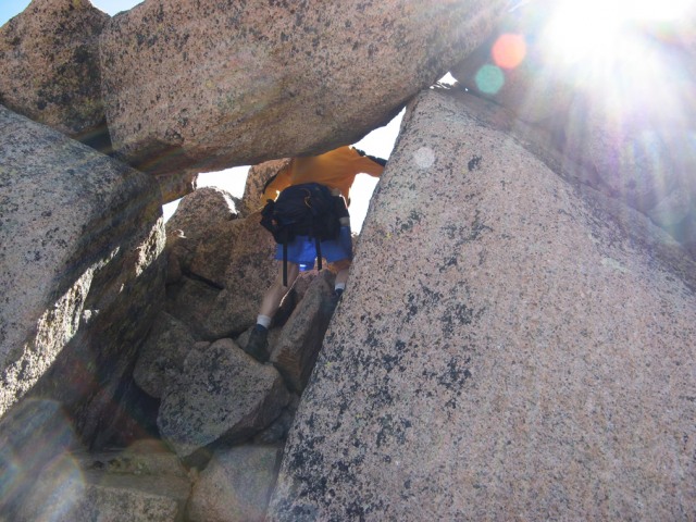 The narrow slot just beneath Sunshine' summit... Hard for us 6'-plus people not to bang our heads! It's not a difficult move, unless of course you whack your skull on the granite above you. After the slot it's a minute or two of scrambling to come to the base of the summit and the oft-talked about summit block. The three climbers in front of us were preparing to rope up for the scramble to the very summit. Chris, being the perfect-balance animal that he is, merely walked over and scrambled to the top of the summit block, making it look as easy as anything. It took me a few minutes to work up the nerve, but eventually I also make the scramble and leap to the summit block, feeling a swell of personal victory over my own nervousness at the exposure. Unfortunately, pictures of climbers on the summit block really don't do it justice, since it's very difficult to get the context of the 1000-foot-plus drops all around. 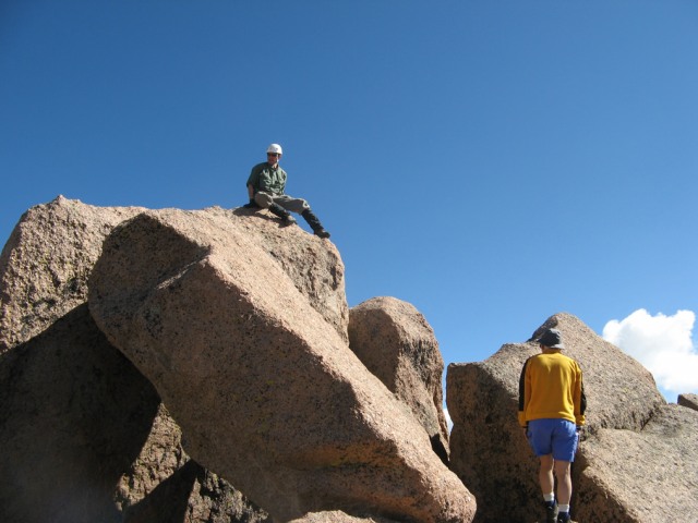 Climbers work the summit block on Sunshine... Roach says this could be the hardest move on any 14er, but I think that's not quite accurate. The move itself is quite simple. Scramble to the base of the summit block and then launch yourself onto it. Roach says the summit block is smooth, but it's really not. It's very "grippy" stone, making it easy enough to get purchase. The reverse move to get down is actually psychologically more difficult, as you have to jump down and just a little out to land on the stone below the summit block. Again, it's not "difficult", it's just exposed. Everyone reacts a little differently to this sort of thing, so use your best judgement and don't feel like a failure if you decide to give the summit block a pass. 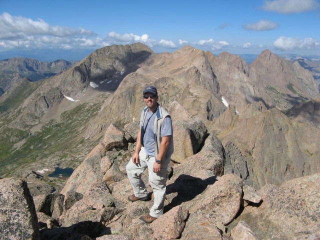 The author on Sunlight, in the summit block 'staging' area with Eolus behind... By this time it was 10:30, and the skies were still looking favorable - a few puffy white clouds but nothing organized yet - so we decided to go for the trifecta and make a run at Eolus. The scramble down Sunlight was probably a tad bit harder than the climb up, but downclimbs often are, especially scrabbling down a couple of the Class III chimneys. And from there it was a half-hour of the scree and gravel to get back down to the basin floor. By the time we rock-hopped back down to Twin Lakes the effort of the day was starting to set in, and we were moving a little slower now. The clouds above were beginning to darken and consolidate, but we felt it was still acceptable to keep moving. A quick refill of the water bottles & bladders at Twin Lakes, and we were off, following the excellent trail into the basin beneath Eolus/North Eolus. As the trail began to climb we started to really slow down. It was 12:30pm, and the 6 hours and two summits behind us were definitely taking a toll. Probably a half-dozen climbers passed us on the way down, offering tidbits of advice about the trail and the weather. We kept grinding upwards, trying to manage 100 ft. of elevation gain and then a short rest. At the base of Eolus the trail takes a right turn and ascends a gradual ramp that can be tricky to find - it's actually the second ramp that inclines to the right. Cairns are in place, but you have to be on the lookout lest you find yourself at a dead end. We trudged up the ramp and curved back to the left as the trail wound upwards to the ridge between Eolus and North Eolus. The final move before the ridge is a 30-40 foot crack that can really be climbed either directly in the middle or just to the right of center, depending on how wide of a person you are. From the ridgeline, Eolus is the imposing mass of rock to your left.  Eolus from the ridge. The 'Catwalk' is in the foreground... Turning to follow the ridgeline, the trail drops just a bit below the ridgeline itself to the climbers' left before regaining the ridge for the famous "Catwalk" section, which was a pleasant stroll despite the exposure. After the Catwalk comes the real fun, as you enter the east face of Eolus to find the best route to the top. Roach is relatively vague about the route, and the standard description on 14ers.com by Bill Middlebrook states that the best route is near to the center of the face. I don't think we went quite that far into the face when we found a well-cairned route that zigzagged towards the summit. True to other route descriptions, the difficulty never exceeded Class III on the route - anytime we were faced with a harder move we were able to retrace our steps and find something easier. There's more than one way, even via Class III scrambling. Frankly, this last section on Eolus reminded my strongly of the final sections of Capitol and Pyramid. Just before the summit a pair of climbers passed us on the descent, one of whom was moving slowly and shakily, but making progress with his partners' urging. Chris and I made the last push and the summit appeared quite abruptly, and we were all alone. 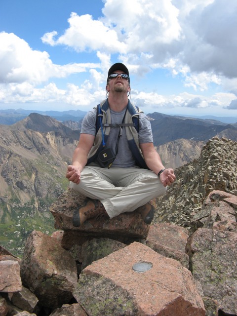 Eolus summit Zen... The celebration of my final 14er would have to wait a while though...the weather was starting to look threatening, and a distant rumble from a cell that we could plainly see to the west told us to keep our summit celebration short (a recollection of getting blasted by a thunderstorm on North Maroon a couple years ago was definitely at the forefront of my mind). After just a few summit pictures and a quick snack, another louder "BOOM" grabbed our attention and we hastily packed up and started our descent, moving quickly but cautiously. At this point all we wanted to was to get off the summit, beyond the Catwalk and below the ridgeline. 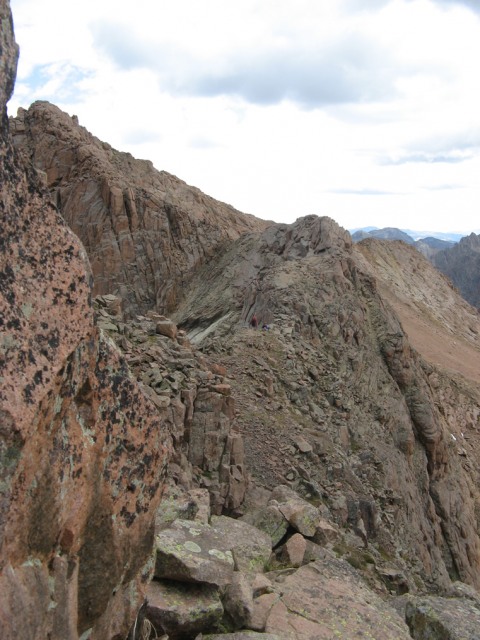 From Eolus east face, climbers can be seen crossing the Catwalk... As with our other summits of the day, Eolus is an exposed place without much in the way of cover or safe, speedy exits. We made record time on the downclimb and practically jogged across the Catwalk as a few more peals of thunder reverberated through the valley. A few minutes later and we were off the ridge and past the two climbers formerly in front of us on our way down the basin. With the exception of a few pellets of graupel and a few drops of rain we didn't really get hit with anything significant. Let me tell you, there's nothing quite like a good, hearty adrenaline rush to erase the pain in your feet and legs and your overall fatigue levels! Of course, the adrenaline wore off before too long, and by the time we'd reached Twin Lakes on the descent the exhaustion was getting pretty heavy.  Wearing down as we approach Twin Lakes... By the time we stumbled back into camp at 3:30, there wasn't much left to do other than peel off the hiking boots and boil up water for dinner. I celebrated my last three 14ers with a faint "woo hoo" before collapsing into my tent. The rain showers that drove through the valley during the night barely made my open one eye. Saturday morning dawned cool and cloudy. The showers of the night before had left Chicago Basin and the surrounding mountains wrapped in fog and wet from the rain. Chris and I were both extremely grateful that we wouldn't have to slog up the muddy trails and scramble across any wet rock this morning. As it was, we got ourselves fed and packed up and headed back down to Needleton. Even though the train from Silverton wouldn't be stopping to pick us up until after 3pm, we figured it would be better to hike down in the cool morning air and hang out at Needleton rather than hang out in Chicago Basin and hike later in the morning when it had warmed up. By 10:30 we were lounging around the Needleton stop with a half-dozen other hikers who had concluded their hiking trips. We ended up back in Durango around 7:00 that night in the midst of the 2008 "Four Corners Biker Rally", which pretty much meant wall to wall Harleys covering Durango. I'm not sure what was more unnerving - sitting on Sunlight's summit block, or being sandwiched between large, leathered, tattooed bikers for dinner at the Steamworks Brewing Company. Heck of a good steak, though. And then on Sunday came the drive home from Durango. The decision to shorten the trip by a day was reinforced by the heavy thundershowers in Durango on Sunday morning, storms which followed us all the way into the San Luis Valley. Thumbnails for uploaded photos (click to open slideshow): ")
")
")
")
")
")
")
")
")
")
")
")
")
")
|
| Comments or Questions | ||||||||||||||||||
|---|---|---|---|---|---|---|---|---|---|---|---|---|---|---|---|---|---|---|
|
Caution: The information contained in this report may not be accurate and should not be the only resource used in preparation for your climb. Failure to have the necessary experience, physical conditioning, supplies or equipment can result in injury or death. 14ers.com and the author(s) of this report provide no warranties, either express or implied, that the information provided is accurate or reliable. By using the information provided, you agree to indemnify and hold harmless 14ers.com and the report author(s) with respect to any claims and demands against them, including any attorney fees and expenses. Please read the 14ers.com Safety and Disclaimer pages for more information.
Please respect private property: 14ers.com supports the rights of private landowners to determine how and by whom their land will be used. In Colorado, it is your responsibility to determine if land is private and to obtain the appropriate permission before entering the property.


