| Report Type | Full |
| Peak(s) |
Wetterhorn Peak - 14,021 feet |
| Date Posted | 07/04/2008 |
| Date Climbed | 07/02/2008 |
| Author | cftbq |
| Nice wetter on Wetterhorn |
|---|
|
Participants: cftbq, trishapajean Start: Matterhorn Creek TH RT: 7.2 miles Vertical: ~3,400 ft. After catching a short night‘s sleep in Lake City (a lot better than no sleep!), we hit the road at about 4:45 am MDT for the short drive up Henson Creek. We made it to the Matterhorn Creek TH just about 5:45, where we met 14ers.com member MountainWoman (El) and her hiking partner, Joey. We set off up the trail about the same time, but they soon passed us. When we came to the trail junction where you are supposed to switchback right up the slope, however, we saw that they had taken the wrong fork and were headed further up Matterhorn Creek. They were already too far ahead to yell at, so we took the correct turn and left them to their fate. A bit later, we could see them backtracking below us. Coming up above timberline, we caught our first views of Matterhorn Peak, and the dramatic ridge that links it to Wetterhorn: 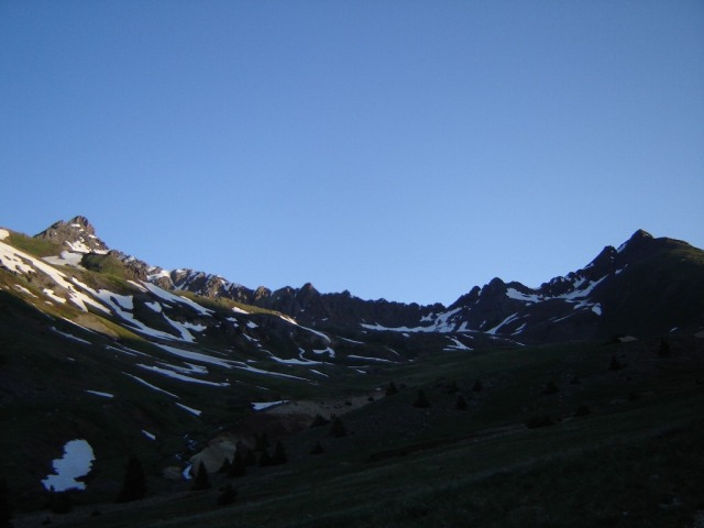 An hour and a quarter after leaving the trailhead, the sun finally hit us:  As we came to the point where the trail firsts begins to traverse rocky sections, we met 14ers.com member NathanHoobler hiking up with his brother Bryson and sister-in-law Sarah, out from Pennsylvania. We would leap-frog with them the rest of the way up. This is a view up through some of the rocks toward the summit:  As we began to encounter snowfields (which were easy to walk over), the sun finally rose high enough to allow a good look at the craggy profile of Uncompahgre to the east:  Still making fairly good time, we gained the SE ridge. Looking up, we could see the Prow peeking out from behind a lower ridge point:  We found numerous useable paths through the rocks along the ridge crest, which we crossed several times. Finally we peeked over the ridge from the north side, and found the famous slanted slab: 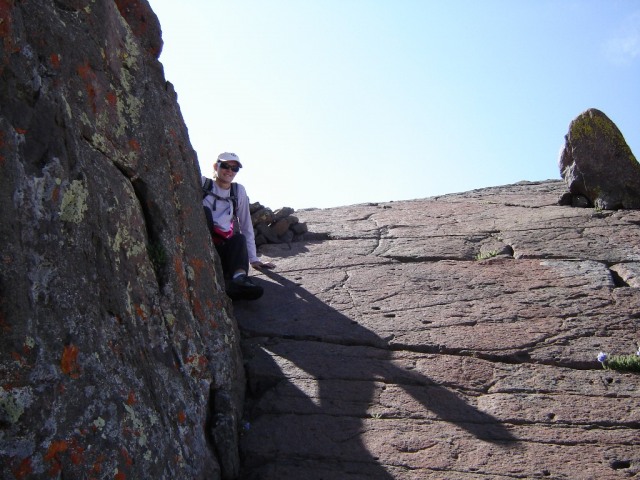 It looks, at first, worse than it is. After that, all that was left was the dramatic system of steep ledges leading to the summit:  I went up first, by myself, to avoid any rockfall danger. Then, Nathan was kind enough to stay within talking distance of Trisha as she ascended, helping her find hand and footholds. Thanks, Nathan! We made the summit at 9:55 am, with the skies still clear, the temperature balmy, and virtually no wind. What a cool summit! We got another dynamite view of Matterhorn and Uncompahgre:  To the west, Coxcomb:  We hung out for nearly an hour on the summit (probably a record!), chatting with all the others, as we all arrived on the summit within a short time. By the time we started down, however, dark clouds were beginning to show up, and we could see rain falling to the north and east. We bailed on attempting Uncompahgre, or even Matterhorn for that reason.  We did get in some good glissades on the way down. The snow had begun to soften, but not too bad. Partly due to this (plus the fact that we weren‘t dead tired!), we made it back to the car in just under three hours. A good thing, too: Five minutes after we got there, it was pouring rain. El and Joey slogged back to the parking area just a few minutes later, having gotten quite wet. The drive back allowed us to see the spectacular Henson Creek canyon, which had been mostly invisible in the dark on the way up. This circular patch of mountain irises dotted one meadow:  All in all, a nice outing in the San Juans. Fourteener #35 for me, #32 for Trisha. Thumbnails for uploaded photos (click to open slideshow): ")
")
")
")
")
")
")
")
")
")
")
|
| Comments or Questions |
|---|
|
|
Caution: The information contained in this report may not be accurate and should not be the only resource used in preparation for your climb. Failure to have the necessary experience, physical conditioning, supplies or equipment can result in injury or death. 14ers.com and the author(s) of this report provide no warranties, either express or implied, that the information provided is accurate or reliable. By using the information provided, you agree to indemnify and hold harmless 14ers.com and the report author(s) with respect to any claims and demands against them, including any attorney fees and expenses. Please read the 14ers.com Safety and Disclaimer pages for more information.
Please respect private property: 14ers.com supports the rights of private landowners to determine how and by whom their land will be used. In Colorado, it is your responsibility to determine if land is private and to obtain the appropriate permission before entering the property.


