Download Agreement, Release, and Acknowledgement of Risk:
You (the person requesting this file download) fully understand mountain climbing ("Activity") involves risks and dangers of serious bodily injury, including permanent disability, paralysis, and death ("Risks") and you fully accept and assume all such risks and all responsibility for losses, costs, and damages you incur as a result of your participation in this Activity.
You acknowledge that information in the file you have chosen to download may not be accurate and may contain errors. You agree to assume all risks when using this information and agree to release and discharge 14ers.com, 14ers Inc. and the author(s) of such information (collectively, the "Released Parties").
You hereby discharge the Released Parties from all damages, actions, claims and liabilities of any nature, specifically including, but not limited to, damages, actions, claims and liabilities arising from or related to the negligence of the Released Parties. You further agree to indemnify, hold harmless and defend 14ers.com, 14ers Inc. and each of the other Released Parties from and against any loss, damage, liability and expense, including costs and attorney fees, incurred by 14ers.com, 14ers Inc. or any of the other Released Parties as a result of you using information provided on the 14ers.com or 14ers Inc. websites.
You have read this agreement, fully understand its terms and intend it to be a complete and unconditional release of all liability to the greatest extent allowed by law and agree that if any portion of this agreement is held to be invalid the balance, notwithstanding, shall continue in full force and effect.
By clicking "OK" you agree to these terms. If you DO NOT agree, click "Cancel"...
Mountain: Mt. Morrison
Summit Elevation: 7,881 ft
TH Elevation: 6,463
Elevation Gain: 1,418
Round-Trip: 1.6 miles
TH Name: Red Rocks Upper Parking
Date: 5/25/2007
Climbing Partner: None
Special Gear: None
Instead of climbing Mt. Evans today, I decided to go a little smaller (and warmer) and climb to a great view of Mt. Evans. I've been up Mt. Morrison quite a few times, and it was good to get up there for the first time in about a year.
I woke up around, 8 or 9am, relaxed in bed for a while watching TV. Decided to roll out of bed around 10am or so after a good 10 hours of sleep. Got my bag together and hit the road. Arrived at the TH to get a prime spot at the upper lot. I left the TH around 11am and headed up the East Face (basically the trail that goes straight up). After some leisurely hiking, snapped this photo looking down on Red Rocks and south along the foothills:
One reason I like climbing this is because it provides a variety of terrain including: loose talus/scree, loose sand, big rocks, flat ground, packed trail, and some vertical scrambling (optional). Here's a picture of some of the lower loose terrain:
And another photo looking up from where I snapped the above 2 shots:
Part-way up the trail flattens out for a nice break before more steep climbing. This is a good place to pull off the trail and take in the scenery and sometimes see some animals grazing to the north (none today):
This route takes the hiker up the old cog railroad grade in parts, and here you see some rails that were tossed off the side when the cog railroad was decommissioned:
A ways up, past the flat area (seen left of center in this shot), and up some more steep climbing, a great view of all the rock formations can be seen:
A shot from above a prominent section of the railroad grade. I chose not to climb up it, but have in the past. The great thing about this mountain is that there are so many choices on where to hike:
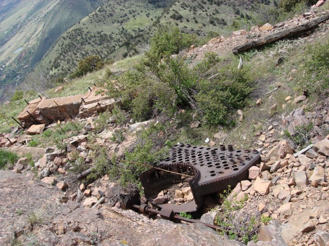
There has been a lot of history on this mountain. An old railroad took tourists to the top to see the view of Denver. There were then some radio towers at the summit (which have been replaced by the newer ones down on the north shoulder). There were the old abandoned structures and a fence surrounding the summit, but I'd say about a year and a half ago they were removed. Still, though, some remains of the old radio broadcasting and railroad can be seen. Here are some shots of those remains:
But there are better views to be had from the summit, Including Mt. Evans:
Of all the times I had been up this mountain, I never took the more popular route that starts just to the south of the trail that goes up the East Face. It is a bit more mild, and is more gradual of a slope. I decided to descend via this route, but wasn't sure where the trail started from the top, so just started down the south side of the summit. I made my way down a talus slope that was not the trail (I met up with the trail later):
At the bottom of the slop, there was a great view down a gully, which looked like an interesting climb up. Who knows, I might climb up this one day:
In order to get over to the shoulder and the trail, I made my way around a corner and to the left of the big green bush in this photo. There is where I met the trail:
The next 2 photos show most of the rest of the route down:
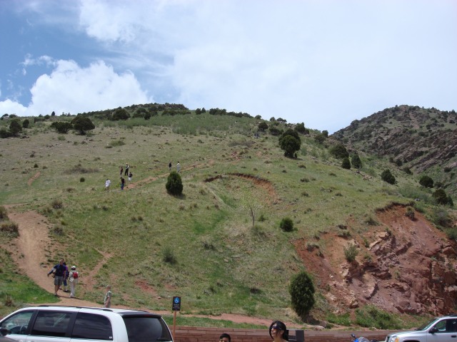
I snapped 2 photos showing the 2 routes from the upper parking lot.
East face route (straight up):
South ridge route (as you can see, lots of people):
It was a beautiful day and very warm. The clouds started to roll in, but that cooled it off and it felt good. Got some good vertical scrambling in toward the top.
Thumbnails for uploaded photos (click to open slideshow):
Nice report but I wouldn‘t call it the south shoulder. South shoulder trail starts right by entrance 4 on the south side, last entrance into Red Rocks before you head upto Kitteridge. I have done this hike almost every week since December, from entrance 4 it is close to 2,000ft elevation gain.
Thanks for the report...I live a few minutes away and have never climbed this. I'm usually on Deer Creek or Dinasaur Ridge (j/k, sorry couldn‘t resist :twisted: )
Thanks for the report...I live a few minutes away and have never climbed this. I'm usually on Deer Creek or Dinasaur Ridge (j/k, sorry couldn‘t resist :twisted: )
Caution: The information contained in this report may not be accurate and should not be the only resource used in preparation for your climb. Failure to have the necessary experience, physical conditioning, supplies or equipment can result in injury or death. 14ers.com and the author(s) of this report provide no warranties, either express or implied, that the information provided is accurate or reliable. By using the information provided, you agree to indemnify and hold harmless 14ers.com and the report author(s) with respect to any claims and demands against them, including any attorney fees and expenses. Please read the 14ers.com Safety and Disclaimer pages for more information.
Please respect private property: 14ers.com supports the rights of private landowners to determine how and by whom their land will be used. In Colorado, it is your responsibility to determine if land is private and to obtain the appropriate permission before entering the property.


")
")
")
")
")
")
")
")
")
")
")
")
")
")
")
")
")
")
")
")


